

AfewUniversesBelowNormal
-
Posts
4,753 -
Joined
-
Last visited
Content Type
Profiles
Blogs
Forums
American Weather
Media Demo
Store
Gallery
Posts posted by AfewUniversesBelowNormal
-
-
I guess it would still be El Nino.. but that's using climate progression as a base. It was much different 2016 - before April 2018.
-
N Pacific pattern doesn't match subsurface data again.. this first happened in March or May 2018.
-
weird.. it's going to roll into -AO next Summer.
-
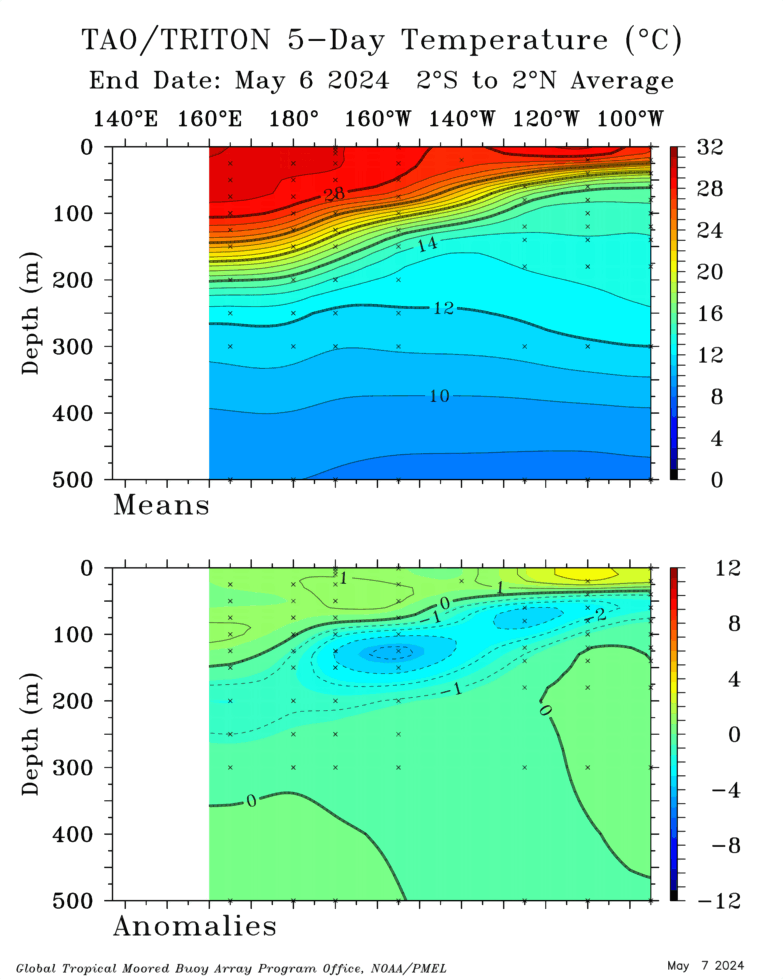
Quite a cold subsurface. Looks like emerging La Nina if correct.
-
Look at this +PNA/-NAO starting to set up

-
I don't know if I'm in the same weather as everyone, but the continued Pacific +PNA is hopeful, and something we didn't see 2016-2018.
-
Really far north for a C storm to develop.. fits my thoughts that bath water is like 2005.. ENSO is Neutral+ though
-
So anomalous it seesawed back as +AO

It's warm at the surface though

-
Maps show no more El Nino.. but we have a strong +PNA / -EPO moving in.. It looks like El Nino conditions still haven't slowed down since April 2018.
http://mp1.met.psu.edu/~fxg1/ENSHGTAVGNH_6z/ensloopmref.html
-
-AO is actually so powerful short term, that it reverses as +AO in 4 days.
http://mp1.met.psu.edu/~fxg1/ENSHGTAVGNH_18z/ensloopmref.html
-
How is arctic ice doing today?
-
Storms around, drought continues. The drought here continues.. I think it's rained once in the last month.
-
2 hours ago, 40/70 Benchmark said:
Care to elaborate?
The jet stream is north.
-
Really evolves around the melting arctic ice. This is 3 days from now, Look at the +PNA

Another Europe heat ridge follows, probably record breaking (like the one France broke 550/1050 records).

-
Major summertime -AO

-
03-04 is a pretty good analog. Maybe with a blend of 12-13.
-
 2
2
-
-
Today a near-600dm 500mb ridge is off the Alaskan coast.
-
It should be accelerating into September. May take it a year to catch up though.
-
I mean wow for arctic ice melt
594 ridge in Alaska

-
Correlations to 2012 in arctic sea ice loss. In 2012 we hit 19 named storms in Neutral ENSO.
-
5 hours ago, Newman said:
Here's a look at how the SST's have changed since June:

Big time N Pacific changes, now correlating with an arctic ice melt. It may be hard to get true +PNA this Winter.
-
Yeah, expect it to stay warmer than normal as we go through the early Fall.
-
Man what a Summer weatherwise
 . We don't get derecho's like before. It is getting better though.
-
Pretty good correlations to a year ago +1 month actually.


Aug Mid/Long Range
in Mid Atlantic
Posted
Nice, sharp -NAO now developing on medium/long range models. Evolves into -EPO..