

AfewUniversesBelowNormal
-
Posts
4,753 -
Joined
-
Last visited
Content Type
Profiles
Blogs
Forums
American Weather
Media Demo
Store
Gallery
Posts posted by AfewUniversesBelowNormal
-
-
Nice subsurface trend uniform cold West warm central moving east. Should be el Nino through jan-feb weak or moderate.
-
 1
1
-
-
Real strong +PNA popping up now.
-
It also has the look of a late-1970s style El Nino for the Fall.
-
1
-
-
Ok, Thanks. I think El Nino will keep out to ocean activity down, but the Atlantic triple pattern could record some good hits.
June 1-0-0
July 2-1-0
August 3-3-1
September 4-3-2
October 2-2-0
November 1-0-0
Total 14-9-3
-
 1
1
-
-
June 1
July 2
August 3
September 4
October 2
November 1
-
1
-
-
Yeah.. STJ. rain lol
-
86 at 11:40, feels like 92.
-
-AO showing up. Could be a big season for SE, US and Gulf hits.
-
Getting hot, will probably be some nice storms.
-
Sky is bright blue, clear. Yesterday the storms moved in as a "high energy front". I would say the same thing happens today.
-
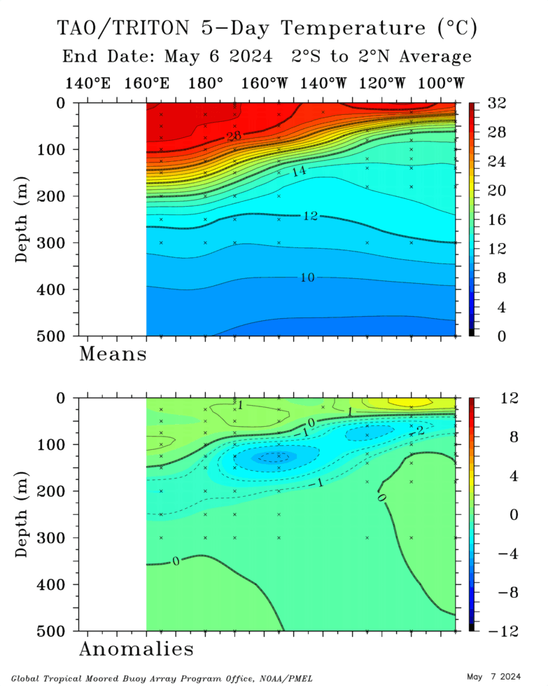
Somewhat of a subsurface recovery, we are still in El Nino. I wouldn't be surprised for Nino 3.4 to warm in the next few weeks.
-
1
-
-
The North Pacific looks very El Ninoish for the next 15 days. Subsurface is cooling. -OLR for the first time in a long time near 180W is going to keep us away from a +north Pacific Hadley cell though, despite neutral/negative ENSO.
-
Subsurface is Weak La Nina, but the +PNA is stringent. Through the next 15 days, wonder why the disconnect.
-
Cold May begats thunderstorm-less Summer
-
It looks like a -AO period really takes hold in the medium and long range.
-
2 hours ago, losetoa6 said:
12z extended 34 hour Hrrr has a couple 5" lollies near DC and Baltimore.
Here we go again [(Major govt interference)]
-
 1
1
-
-
As expected, we're getting this near-surface subsurface warming
-
Pretty strong El Nino pattern coming up

I think we are still going into El Nino
-
Kind of disappointing.. you could tell earlier today with the way the clouds were low and throughout that it wasn't going to do clear enough for storm. Lifted index is -3 to -4, radar is dying out a bit.
-
Look at all these storm reports already today


-
Classic El Nino looking pattern on the long range GFS

-
Look at this +Nino 1.2 cold-PDO difference in the last 7 days
https://tropicaltidbits.com/analysis/ocean/cdas-sflux_ssta7diff_global_1.png
-
Looks good for tomorrow.

-
It might just recenter West and ramp up for a Fall-Winter 2019-2020 El Nino
Get some cold 1.2 readings over the Summertime for hurricane season
2019 ENSO
in Weather Forecasting and Discussion
Posted
huh?