
AfewUniversesBelowNormal
-
Posts
4,753 -
Joined
-
Last visited
Content Type
Profiles
Blogs
Forums
American Weather
Media Demo
Store
Gallery
Posts posted by AfewUniversesBelowNormal
-
-
After this, I can't imagine much more named storms unless a La Nina develops (we are in nowhere land).
-
I don't know, it would be hard to bet against a shorter term La Nina, at least in Nino 3. The subsurface warmer pool will push a cold wave to the surface in Nino 1.2 and 3 for at least the next month.
-
Well, Winter is breaking into the West and Rocky Mountains.
https://www.cpc.ncep.noaa.gov/products/predictions/610day/610temp.new.gif
https://www.cpc.ncep.noaa.gov/products/predictions/814day/814temp.new.gif
It looks like it's going to be another one of these type of years.
https://www.cpc.ncep.noaa.gov/products/predictions/WK34/gifs/WK34temp.gif
-
Here comes the La Nina.

My prediction is developing La Nina.
-
40 minutes ago, C.A.P.E. said:
It's early. I generally like how things look in the ENSO region right now- neutral but the SST distribution has the anomalous warmth focused more in the western Pacific. If that holds we could end up with the atmosphere behaving more Nino-ish than last winter, assuming the MJO or some other forcing mechanism doesn't overwhelm again. Looking at the SSTs in the PDO region, it looks like it may be heading in the direction we want(da blob!), but its difficult to tell at this juncture and we have seen this somewhat nebulous look before, only to have the anomalies dissipate/shift moving deeper into Fall. Again it's early. Also have to like the QBO trend as we head towards winter this year.
You'd always see this ENSO configuration in a generally warm Earth because of land/mountain torque.. Any warmer and it's biased El Nino (Nino 1.2 and 3 are cold).
-
Hard to imagine the weekly of Nino 1.2 or 3 doesn't hit -1.0 in the coming weeks/months..
-
Just like everything, it's averaging out in time. Big time -AO develops as soon as the ice accretion starts.
-
Looking at medium/long range models, it's really hard for a +PNA to form. Skewed toward -PDO, like we've seen 2014-2019 in the long wavelength season. The Aleutian High becomes a block in about September and the same is holding true this year.
http://mp1.met.psu.edu/~fxg1/ENSHGTAVGNH_6z/ensloopmref.html
I mention this because we had +PNA all year up until about 7-10 days ago. This -PDO is a pattern that will hold.
-
Another dry winter for the West coast...
-
I wonder how it would be if people lived in Greenland?
http://mp1.met.psu.edu/~fxg1/ECMWF_12z/hgtcomp.html.. That's why.. oh, space weather was a +25% research and I stopped it for whatever reason.
-
I think the Atlnatic SST index NAO index argues for a -NAO higher frequency.
-
Not a Winter blizzard pattern

-
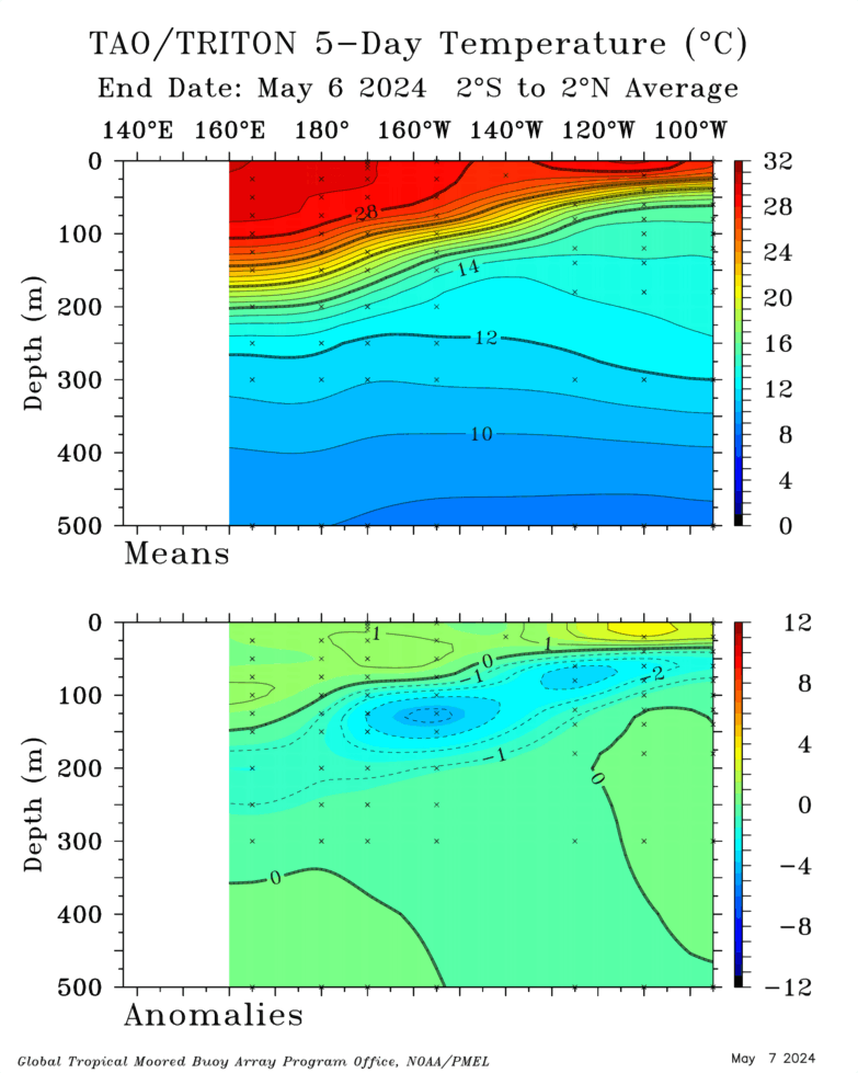
ENSO Subsurface getting more La Nina like for an active October, possibly. it will take a pattern change...
-
To boot, we have La Nina wavelengths
-
Pretty bulllish La Nina sign
-
How about the coming +PNA/GOA Low on models days 14-15.
-
It's been a different pattern - It's rained in SF something like 3 times in 4 years (just an example, probably not accurate). Alaska is warm I bet because of the population. etc. It could be different for everyone, I guess. It's already a much different pattern from last Winter, Anchorage AK broke their July record by 2 degrees.
-
 1
1
-
-
I like that the 2000-2019 base is holding.. warm Nino 4, cold Nino 1.2. Subsurface configuration has remained mostly active ENSO throughout the year.
-
I don't know what that has to do with ENSO! Subsurface configuration has held good amidst changing global conditions through the year.
-
I'd say it looks more Neutral, El Nino pattern broke a short time ago now we are in Neutral wavelengths. It broke like 7 days ago.
-
Pretty major +NAO, evolving to -PNA in a few days. Signing toward a jet stream 300 miles north this Winte rimo
-
Southern Hemisphere stratosphere doesn't mean much I think except for general "warming-neutralizing".
-
 1
1
-
 1
1
-
-
3 hours ago, frd said:
Crazy stuff at the South Pole and in general the SH SSWE
It's been a really "neutralizing time".. not really surprising. I'd expect a warmer than average Fall. At least we have Fall, that starts on like Aug 31 lol.
-
New -PNA conditions are a cause for concern. I'd expect the PDO to go from +1.70 to about +0.55
2019 ENSO
in Weather Forecasting and Discussion
Posted
Looks like a La Nina making. I doubt anything real could develop in this environment.