

hawkeye_wx
-
Posts
5,948 -
Joined
-
Last visited
Content Type
Profiles
Blogs
Forums
American Weather
Media Demo
Store
Gallery
Posts posted by hawkeye_wx
-
-
Chicagoland members won't like the 12z Euro. It has shifted the 500 mb low north to the I-80 corridor (last run was northern MO to central IL), and the surface low gets up to Chicago, so the snow band has moved up into Wisconsin and the WI/IL border region. We don't need this trending any farther north.

-
 2
2
-
-
The UK just doesn't want to play ball, yet. The problem appears to be the UK is speeding the first wave eastward faster than the other models. It has the trailing upper low like the others, but the first wave is so fast it does not get captured by the trailing energy, so the entire system ends up weak and moisture-starved. I thought we'd see improvement this morning, but this run is actually a step backward again.

-
 1
1
-
-
Yeah, the Canadian still has the trailing energy digging farther south. The surface low hangs out in southern IL/IN as the upper low catches up. The GFS takes that surface low and lifts it well north.
12z Canadian... pretty steady the last few runs.

-
3
-
1
-
-
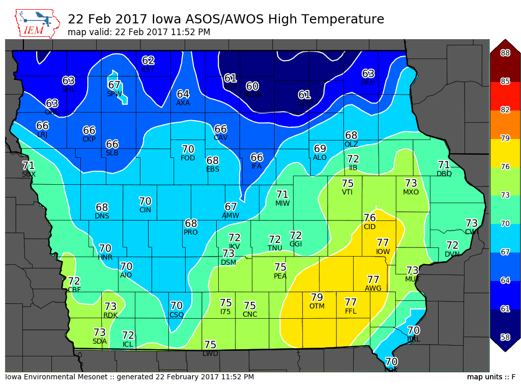
This was the temp map three years ago. Ottumwa nearly hit 80º, which is insane for February.
-
2
-
-
The GFS is sticking with the north route. The surface low gets all the way up to near Green Bay, so it's WAY up there. It is stronger, though.


-
1
-
-
FWIW, the NAM is north and strong.

-
1
-
-
00z Euro is hot for areas nw of the UK. It appears the Euro wants the trailing energy to grab ahold of the lead energy more than the UK, and it obviously tracks the trailing energy farther north.

-
1
-
 1
1
-
-
We won't have a better idea of what the trailing energy will do for another 1-2 days. It won't come ashore in Washington until sometime Sunday.
-
1
-
-
00z UK is better than the dud 12z, but it's not nearly as far nw as other models. This run does spin up the trailing energy decently for our central/eastern members.

-
1
-
-
The GFS is well north, but it's pretty meh.
There is definitely a north trend from the models so far this evening. The NAM and ICON are more robust with the snow band, but they are not the top models.

-
FWIW, the 00z ICON has shifted north quite a bit, with a solid phase. The snow band is now Iowa northeastward into WI and northern MI.
-
2
-
-
That's a pretty good snow swath considering the lead system sweeps away so much moisture.
-
1
-
-
Models are now focusing on the lead system, tracking it a bit farther north. Unfortunately, while we are pretty cold now, the cold will be gone when the lead system arrives.
-
Meanwhile, the Euro shows a moisture-starved clipper.
-
 1
1
-
-
Models are all over the place next week with both track and type of system.
-
1
-
-
54 minutes ago, Luftfeuchtigkeit said:
6.0" storm total yesterday, depth is 13". Very pretty snowfall, but wet and tiring to shovel.
Forecast was for 1-3", so this way overperformed. We finally got a winter weather advisory late in the afternoon after most of the snow had already fallen.
The Euro and UK both had 4-5+" in Madison. A couple other models were too dry and/or rainy.
First thing in the morning, when it was snowing solidly in the Dubuque area and a nice plume of precip was aimed directly at the Madison area, it seemed pretty clear Madison was going to beat the NWS forecast of 1-3". Congrats. Over-performers are always nice.
-
1
-
1
-
-
19 minutes ago, cyclone77 said:
As expected the HRRR from yesterday was way too warm that far north. If we could have had slightly better WAA today ahead of the front this could have been a nice little thunder event at least.
I'm itching for some lightning/thunder, but the temp was stuck at 34º all day.
-
 1
1
-
1
-
-
It's still snowing in Dubuque, so Madison appears to be in a pretty decent spot.
-
1 hour ago, Snownado said:
I don't see how a record of -11 seems pretty mild considering we are just 2 weeks from March.
-11 is tame for Dubuque. If you take away the 29th (leap year day), -11 was the mildest February record low in Dubuque. Yesterday's record low is -25. Remember, only two weeks ago, last year, Dubuque hit -31. Dubuque's record low on March 6th is still -11.
-
2
-
-
1 hour ago, Chicago Storm said:
Along with the record of -7 on the 13th, the former record of -8 for today are both actually the only two record lows not -10 or lower for early/mid-Feb (Feb 1-25th).
Dubuque was able to set a new record this morning for the same reason. Strangely, while Dubuque's old record for today was only -11º, which seems pretty mild, Cedar Rapids' record today is -27º.
-
This morning's UK is the only model that still has anything around here.
-
My snow total is 1.7", right in line with what models suggested.
-
1
-
-
14 minutes ago, cyclone77 said:
Yeah I went out a little while ago and removed most of the snow. Figured I'd get it off now before it freezes up some, as there is a decent amount of water in it. Very peaceful out there with the snow gently raining down, with zero wind. Very quiet out as well.
I considered going out to clean off the wet stuff, because I know it's a real PITA to clean once it freezes. However, I don't feel like going out this late. Plus, I did not notice any real slushy layer, so it may be ok.
-
1
-
-
I think I'm going to end up with around an inch, which is what I expected. The temp is quickly falling now... currently 23º. It is going to be rather brutal in the morning when I'm out shoveling (temp near 0º with -20º wind chill). The 2013-14 season had a lot of morning-after cleanups like that.
February 2020 Discussion
in Lakes/Ohio Valley
Posted
That's exactly what I thought. At first glance, it looks like your typical "southern Iowa is mild, northern Iowa is cold behind the front(or still stuck with deep snow)" map, but then you realize the "cold" is 60º.