Met1985
-
Posts
16,564 -
Joined
-
Last visited
Content Type
Profiles
Blogs
Forums
American Weather
Media Demo
Store
Gallery
Everything posted by Met1985
-
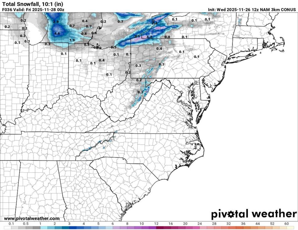
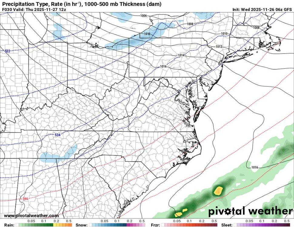
3K NAM picking up on this moisture as well. Nothing major but will feel like winter. Sent from my SM-G998U using Tapatalk
-
Could see some flakes tomorrow for Thanksgiving. Going to be freaking cold too just in time for Thanksgiving. Sent from my SM-G998U using Tapatalk
.thumb.jpg.91fed4eeac72f2f53a28cce7c13aa2c7.jpg)
.thumb.jpg.d0732583843dbfff90ac6ed0bd1065f4.jpg)
-
A step in the right direction. Models are far from seeing the pattern out into December.
-
Was looking at that. Temps are going to crash as well.
-
Im not surprised at all with the volatility from basically all the models. We had an SSW or at least a significant weakening of the PV. We also have the MJO doing its thing and it's a good thing at that. The models have had a really tough time in the mid-range this season. A lot going on in the atmospheric river.
-
Same crap different season. It's fun to watch. Get ya popcorn!
-
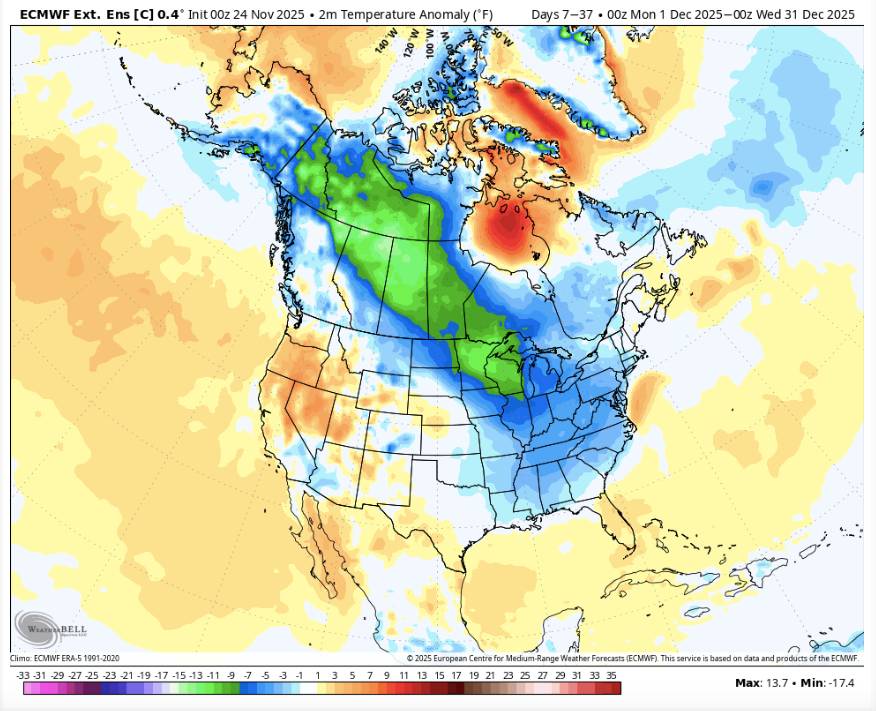
Borrowed this from @Carvers Gap. This is the most recent run of the Euro control run for the month of December. Not a bad look at all. Still will be a lot of back and forth but positive. Sent from my SM-G998U using Tapatalk
-
Positive steps today on the models. It's not like we aren't seeing Positive trends here. Especially when considering the MJO is moving in the right direction. Yeah this current weather sucks but hey the colds coming.
-
Typical La Nina look bro. You cooked already?
-

December 2025 Short/Medium Range Forecast Thread
Met1985 replied to John1122's topic in Tennessee Valley
Yeah yesterday didn't look as good but I mean it freaking changes daily. But even a weakened state helps tremendously. -
I'd honestly prefer to get deeper into December.
-
Everything is looking great my man.
-
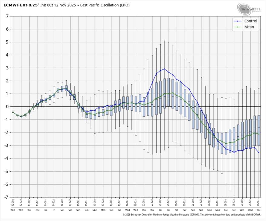
From Allan Huffman Well for all you #SSWE people out there. Today's 00z EPS showed all members (100%) showing a 10mb U wind reversal over the north pole around 11/28 to 11/29. The implications, are enhanced blocking risk in December and the possibility that the SPV will be further receptive to weakening later in the Winter which could influence the mid/late Winter. Sent from my SM-G998U using Tapatalk

-
December 2025 Short/Medium Range Forecast Thread
Met1985 replied to John1122's topic in Tennessee Valley
From Allan Huffman. Well for all you #SSWE people out there. Today's 00z EPS showed all members (100%) showing a 10mb U wind reversal over the north pole around 11/28 to 11/29. The implications, are enhanced blocking risk in December and the possibility that the SPV will be further receptive to weakening later in the Winter which could influence the mid/late Winter. Sent from my SM-G998U using Tapatalk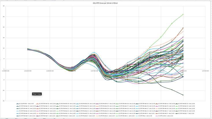
-
December 2025 Short/Medium Range Forecast Thread
Met1985 replied to John1122's topic in Tennessee Valley
Im getting conflicting data. I just saw a post that said the 00z EPS looks like a go for wind reversal. Although the PV being in a weakened state works as well. -
This is a typical La Nina look actually. Dumps west then moves East or thats the idea. Still a lot to iron out though but Iike things heading into December.
-
Very true and hopefully we cycle through to better years with more snowfall.
-
That's our climate though. Usually people outside the mountains just need 1 big snow to make their annual snowfall.
-
Nothing we don't know especially the past 5 winters. Hopefully things look up starting this winter.
-
What a weird day with the temps today. Only had a morning time low of 55 then got up to 63 but have dropped down to 49 already and that's our low also so far.
-
Honestly a transition the first of December would be best climatologically speaking.
-
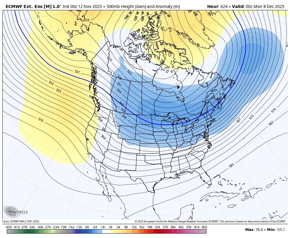
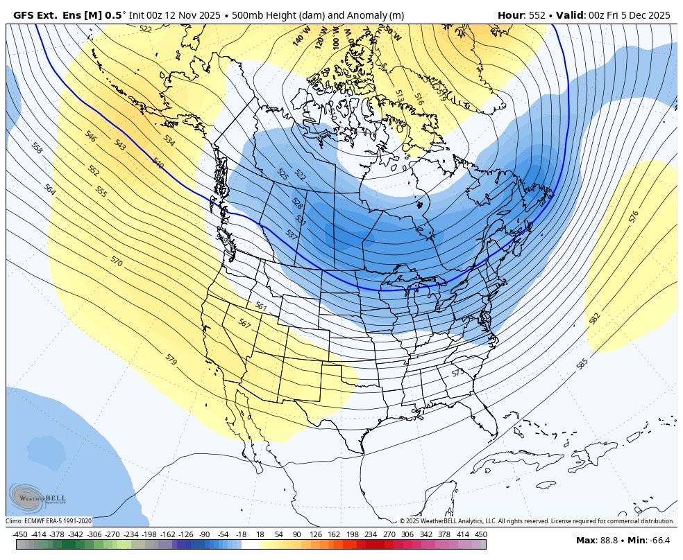
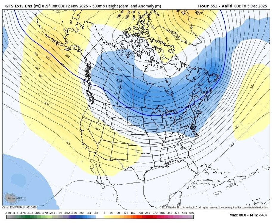
GFS and Euro ensembles overnight are showing the goods in the long range. Sent from my SM-G998U using Tapatalk

-
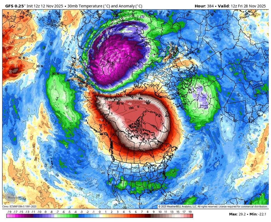
Pretty colors of the PV warming. Sent from my SM-G998U using Tapatalk
-
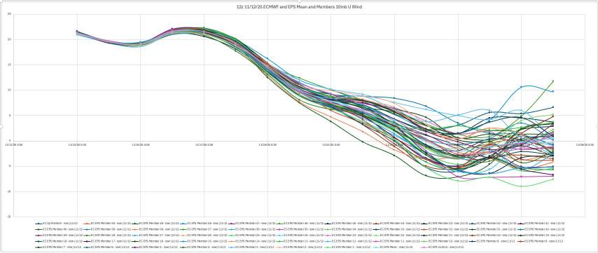
Great stuff from Allan Huffman. Today's 12z op ECMWF and EPS mean both show the 10mb U wind turning negative, meaning a change to an easterly wind direction over the polar regions and an #SSWE with 41 of 50 EPS members (82%) showing this reversal with 11/25 the day with the most negative members. Sudden Stratospheric Warming Events, can weaken the tropospheric polar vortex, allowing for increased high latitude blocking (-AO) and the enhanced risk for arctic air discharge into the mid-latitudes (North America, Europe, East Asia). A late November SSWE is relatively rare, and COULD help favor a cold start to meteorological winter(December). The last November SSWE was in 1968. Sent from my SM-G998U using Tapatalk
-
A great sign moving forward right around Thanksgiving which could usher in cold air along the East. Sent from my SM-G998U using Tapatalk


.jpg.450bd542b9324d89971c945b21697213.jpg)
.jpg.9194b49ba95e90f12bdfea38786301b8.jpg)