

RogueWaves
-
Posts
2,256 -
Joined
-
Last visited
Content Type
Profiles
Blogs
Forums
American Weather
Media Demo
Store
Gallery
Posts posted by RogueWaves
-
-
8 hours ago, cyclone77 said:
Cold and dry.
Bound to happen sooner than later. Can't keep up the non-stop flooding forever. Also, can't buy a balanced stretch of wx. It's gotta go flipping extreme one direction then the other. My 2 cents fwiw
-
I love that map and have spent hours confirming that it's pretty damned accurate all things considered. Cool find. Thx for re-sharing the link that got lost when my pc died unexpectedly.
-
3 hours ago, Hoosier said:
Some of the latest info does suggest a possible weak Nino for winter. May fall a bit short. It could end up being a case of Ninoish but not meeting the technical criteria of 5 consecutive trimonthly readings.
It's a noteworthy trend that many of these storms are acting much like the biggies in 77-78 which was a weak Nino. Strong storms at peak intensity stalling, looping, drifting, etc. No low solar to blame back then tho, which we have going on right now aiding high-lat blocking. It's uncanny and hopefully continues into winter.
-
 1
1
-
-
3 hours ago, Chambana said:
Didn’t the winter of 2013-2014 get off to an abnormally early start? I think the plains were hit with a massive snowstorm like the first few days of October??
Some similarities between now and 2013 as well as far as ENSO, the blob, solar etc..
EDIT: it was October 3-5 2013. Almost the same areas affected by this blizzard as well.
Yes to all above. As you said, ground-zero for that storm was more or less in the middle between this year's two pre-season beasts. 2013 had the most extensive early snow cover build-up of the past couple decades. 2019 is in 2nd or 3rd place to date, but may be on a roll. Could we catch, or even surpass 2013 over the next month? "Don't touch that dial.."


-
1
-
-
That chilly morning in the 30s this week triggered some color finally. Tough to get good shots with all the rain today but snagged a couple decent ones.


-
5
-
-
Denver went from 82F late yesterday afternoon to 21F and snowing at 7am. Stuff of yore right there my friends.
-
2 hours ago, Hoosier said:
North Dakota is going to get slammed.
As we come up on the 30th anniversary of the more freakish Oct 1989 snowstorm that blasted IN and surrounding areas. I think Chicagowx once called it the fluke of the century, which is not that far off the mark for the areas affected. Certainly a once in a lifetime type of thing at most.
Back then, I followed winter wx (in winter). I don't remember hearing or seeing anything on news the night before about snow. When I stepped out the morning to moderate snow falling on a stiff easterly wind I thought maybe I'd slept 2 months away overnight. It had the feel of Dec 19th. This was in SEMI where Oct snows are rare beyond a flurry or brief shsn.
-
3 hours ago, Hoosier said:
Not really a believer in the LRC. Not to say that general patterns don't repeat but I think people tend to twist things to try to fit the "LRC"... at least from what I have observed.
I don't subscribe to the cookie-cutter version he touts either. I do however feel strongly that each cold season has a certain syncopation that sets up during late Sept/early Oct as the PV begins to strengthen and the Jet comes to life. This rhythm maintains it's beat throughout the cold season, but the location obviously will vary as the action zone works it's way from northern lat's on southward as we go deeper into the season.
-
3
-
-
37F here this morning. Not exactly summer but I think we narrowly missed a true frosting on our pumpkins.
-
56 minutes ago, A-L-E-K said:
love the extended, hope to lock this look in all winter
Some nice things on the table going forward thru this month of transition, that's for sure.
A few tidbits from Lezaks blog this morning on this upcoming storm and this years LRC.
- There is a strong cold front, and it is well defined. Last year the fronts over the plains were rarely well defined, and certainly nothing like this.
- The temperature contrast is from the 20s to the 90s. It will be fun to show this on NBC tonight on KSHB, 41 Action News.
- The upper level storm system is unlike anything we have seen in years. Oh, there have been upper lows that have ripped out of the Rocky Mountains, but nothing like this one, and the waves rotating around the storm are so different than anything we experienced a year ago.
- There is one wave rotating around the base of the storm as you can see below. This wave will help produce the energy for a few severe thunderstorms, and there is a risk from the SPC
- And, another wave is forecast to rotate around the main storm that will produce a potential band of rain and thunderstorms in the colder air north and west of the front. This must be watched to see if this exists in other storm systems this winter. It likely will, but lets see it happen first.
-
1 hour ago, buckeye said:
meterologist confucius says:
whomever gets the love early, gets the shaft later.

By the way....welcome back Steve
A CF brought some rain..it's a start

-
A lot of (early) outlooks showin OHV "the luv". Let's see where we are going into November.
-
1
-
-
1.06" overnight taking KRMY to a 2-wave total of 2.14"
-
17 hours ago, Frog Town said:
Not gonna lie, I've been hoping for this thread to started as well! Way too early to get excited about any particular prognostication, but the CDC's outlook gets me excited about my first Great Lakes Christmas Ale during the first flakes!!
Perhaps, but here's a couple decent ones that should have you N. OH peeps at least mildly enthused..if you have a pulse. One must
 on as we approach a fresh winter ahead!
https://www.weatherbell.com/preliminary-2019-2020-winter-forecast
Heck, even runner-up analog seasons look pretty tasty compared to the last (3) seasons imby. I'm cautiously excited based on current SSTA's holding serve into the DJF time-frame, with a more or less La-Nada look staying the course. The "Blob" in the NPAC needs to remain stout - that'll be key imho.
-
 1
1
-
-
I'd like this to be a (positive) signal for the winter ahead. Ofc, October storms don't often work out that way, do they?

Who mentioned OH was overdue for a classic winter GOMEX bomb storm?

-
1
-
-
On 9/23/2019 at 4:25 PM, Stebo said:
Love seeing 2010 show up, that fall had a good amount of severe and the winter was spectacular.
Detroit killed it winter of 10-11
-
20 hours ago, Jackstraw said:
Hoping we get something tonight. It's parched around here. Any exposed bare ground looks like a dried lake bed. No measurable precip locally for almost the entire month.
17 hours ago, Jackstraw said:This is getting ridiculous. The N part of this front is falling apart as it comes through this area. This is like the 3rd one over the last 3 weeks where the precip went N and S of here.

Went (10) full weeks w/o meaningful qpf at my place. Cells would miss me by a few miles in any direction including firing just east. Talk about a frustrating summer with a local drought island and staring at my brown lawn for week after week! Damn near got whiffed by this "heavy rain event" as well. This has been prevalent since Feb's snowstorms had a sharp cut-off right thru here. This pattern needs to die..
51 minutes ago, King James said:
Came here to see if anyone mentioned how awful the forecasting was for this oneYou can say that again! Saturday morning's map had 1.5 to 2" widespread across my area. Net event total ended up being a whopping 0.16"
-
On 9/19/2019 at 3:33 PM, Hoosier said:
Your memory is not bad. It was a bomb out of the Gulf in late February. Saginaw had about 18", which was one of the high totals in the storm.


A 970's mb SLP in Ohio, and so late in Feb no less. Quite the sight. I was 5 mo old. Don't remember a flake, lol. My folks had a photo dated '65 and It's likely this storm which was a standout in an otherwise lackluster season. I also consider this storm the beginning of the 2 decades (65-85) of atmospheric alignment that brought historic storms and events across the GL's/OHV during my youth. What I wouldn't give to see that alignment re-established. Those were exciting wx times!
-
50 minutes ago, snowlover2 said:
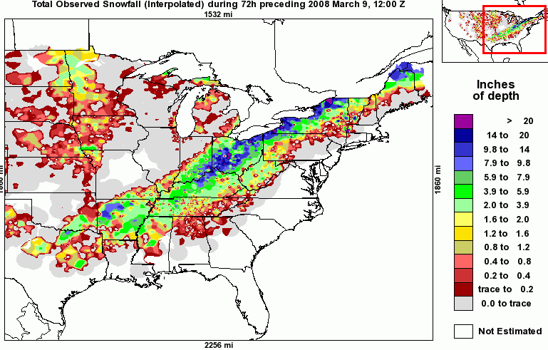
Northern parts yes. Also almost forgot March 7,8 2008. Most of the northwestern half of OH were under a blizzard warning receiving 10"+.
Per that map, the heaviest cut right thru the middle of the state...a certain rarity
-
38 minutes ago, BuffaloWeather said:
We got 22" from that storm. Places near Erie had over 30"
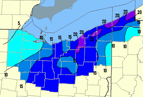
That was the rare Apps running bird right there
-
1 minute ago, Hoosier said:
I'm familiar with all of those except 1894. What date was that?
..and I was wondering the specifics on '65. Was that the Feb storm that bulls-eyed some corn fields in NWOH?
-
On 9/18/2019 at 9:55 AM, buckeye said:
I saw it posted in another forum. Looks like they have Ohio in the epicenter of greatest snowfall departure from normal, (150%). lol
Pretty likely we have a typical winter. 1 hyped event that ends up severely disappointing and a heapful of pennies and nickles as we scratch our way to average snowfall. Safe bet.
I thought to myself the same. Riskiest call of all = Ohio mega-winter. IF you wanted a recipe for a forecast disaster, that'd be it, lol.
Can Vegas even calculate the odds??
-
19 hours ago, Angrysummons said:
Ohio(mainly the western/northwestern portion gets the bulk of the storms since 1864) is really due for a major bomb. The last real one was 1993 on the eastern edge of the state. Before that you had 1978, 1965, 1950, 1918, 1913, 1894, 1864.
18 hours ago, snowlover2 said:Actually 2004 pre Christmas dropped 20"+ across the western half of the state so arguably that was the last real big one.
WxBell's map actually looks quite a bit like the Dec '04 event, and/or winter of 1917-18. I'd give you both credit. Also, iirc, 2-14-07 was pretty big across OH?
-
On 9/5/2019 at 7:15 PM, roardog said:
Everyone in this subforum would love the current Weatherbell winter forecast.
Who knows? After getting kicked around with last winter's busted forecast, maybe the wx gods will have pity and let him get one right?


Winter 2019-20 Discussion
in Lakes/Ohio Valley
Posted
NHemi Snowcover is like 2SD's above avg, and Canada looks to fill-up rapidly with snow in the next couple weeks. Won't be much to put the brakes on an early onset of that. Get ready! Cohen's blog today mentioning a slight perturbation of the PV last week of October and the CFS has a very eastern trough look for Nov. Last Nov here was no. 3 all-time for snow, with no. 1 all-time just a few miles to my west. I thought we'd get back to dull boring Nov's per the norm this year. Not so sure about that now.