

Amped
-
Posts
13,657 -
Joined
-
Last visited
Content Type
Profiles
Blogs
Forums
American Weather
Media Demo
Store
Gallery
Posts posted by Amped
-
-
Getting blasted with wind now.
-
18z GFS gives us a quick dusting day seven. Seems to be the only events that produce anything along I95 anymore.
-
E or SE winds get funneled into nyc metro by the shape of the coastline. The effect was clearly felt in March 2010, Sandy and Isaias.
-
 2
2
-
-
Amped up -PNA = Cutter. The NAO isn't going to help. Hopefully something changes.
-
The PNA is not being nice to us on the Euro
-
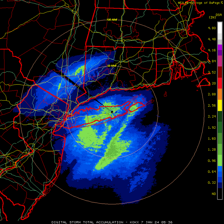
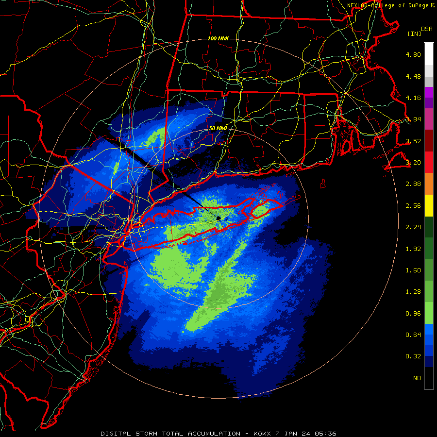
Radar estimates showing the jackpot was over Pawling NY. Interesting to see if there is a spotter confirming it.
-
1
-
-
6 minutes ago, Sey-Mour Snow said:
Some 9-10" reports in Sussex county NJ, also 4" in Greenwich all reports from the NYC forum..
1.4" here 5 hours of snow.. looks like a major bust for this area from the WAA
3" in 1hr report from Middletown NY.
-
1 minute ago, snywx said:
27 w/ heavy snow
6.0" otg
3" in the last hour
That band is impressive. Congrats
-
RGEM pretty much matches it's 18z run except for a snow hole near York PA. NAM could never dream of being that consistent.
-
3
-
-
3k up to it's usual overemphasizing the mountains.
-
NAM's gotta take the low out to sea and then tuck it back into eastern long island. Euro actually hooks it the other way into Cape May then east off the Jersey coast.
-
How does the NAM reform the low 300 miles to the ESE between 21 and 24hr? This model never stops being entertaining.
-
-
February track. Just moves a little too fast for 30" totals.
-
Already more than last winter.
-
1
-
-
This wasn't supposed to happen for like another 30 to 50 years.
-
7 hours ago, gymengineer said:
Preliminary recorded wind gust of 205 mph:
https://weather.com/storms/hurricane/news/2023-10-31-hurricane-otis-extreme-wind-preliminary-report
963mb and no calm. Doesn't seem like they even got in the eye.
-
On 10/30/2023 at 5:30 PM, Windspeed said:
Amazing a lot of the pics we've seen are of the buildings are only listed as damaged when they have some very severe damage that may take years to fix.
-
I know I am inferring wind direction based on damage here. But this is a video that shows lots of boats smashed into the shore. I geolocated the light house on google maps and it's RentaYateAcapulco. It is on a north facing beach on the hook of the western peninsula. The damage would imply winds were out of the north there. This could mean the storm tracked straight over the bay which is a few miles east of the official track.

-
Not good, but not unexpected either. Judging by the damage, the final death toll will probably be in the hundreds.
-
43 minutes ago, olafminesaw said:
Just imagining how much broken glass they'll have to avoid stepping on for the next 20 years.
I don't know building codes there. If they didn't require storm windows that could help explain the near 100% failure rate of high rise windows across the city.
-
1
-
-
Despite being small you couldn't have asked for a worse track. It dragged along the coast and everywhere between the International Airport and Pie Del la Cuesta got hit by the eyewall, including the tourist district on the west side of the bay. At least that's my guess based on the damage.
-
Surprised this is fading from the news so quickly. The damage keeps looking worse and worse as pictures come in.
-
1
-
-
20 minutes ago, olafminesaw said:
It does seem like a lot of the construction in residential areas is more concrete/cinder block, as is more typical in Mexico. So hopefully the general population fared better than what we have been seeing.
Depending on the anchor bolts of course.
Tuesday, January 9 Rain and Wind Storm
in Mid Atlantic
Posted
Only another 3 or 4 hrs and a couple of squall lines left to go.