

1234snow
-
Posts
1,725 -
Joined
-
Last visited
Content Type
Profiles
Blogs
Forums
American Weather
Media Demo
Store
Gallery
Posts posted by 1234snow
-
-
A line of broken severe storms has moved off the mountains into the valley/Knoxville area with several severe warnings.
Also there is a line of storms back in Illinois advancing southeast. Those probably won’t make it but an interesting flow in the storm directions today.-
 1
1
-
-
I'd happily send some your way if I could. Meanwhile it's pouring here again.
Just north of you across the KY line close to Jelico have received up to 6 inches of rain today. -
-
Next round of rain is moving in. Unfortunately WPC has placed Eastern KY and a small portion of SWVA in a moderate risk for flash flooding today. Hopefully that is just a precautionary measure due to the recent devastation. The rest of TN is in the slight category.
Radar estimated that 4-5 inches of rain fell since Monday here at the house. No flooding issues here thankfully unlike our neighbors to the north and northwest in SWVA/KY. I finally got my jungle of a yard mowed on Saturday. -
Had a big storm roll through around 2 am. Lot of lighting and heavy rain. Radar estimate is up to around 1.50 starting Monday.
St. Louis, MO area getting rocked by historic flooding of up to a foot while cells are still training over the area.-
 1
1
-
-
One the plus side, my yard was gone from "crispy brown" to green in the places which are still alive! Whiplash gardening this summer to paraphrase [mention=6441]1234snow[/mention].
Got hit twice today by storms. Radar estimate is around .75. New Tazewell, Tazewell, TN shows 2-3 inches of rain and under a FFW.-
1
-
-
Chunks of northern Middle and East Tennessee are in the WPC excessive rainfall outlook the next two days. My how things change. Gotta love the Tennessee Valley.
About the heat. Fades middle of the week through next weekend if no sharp model changes. More thundershowers. About the following week to start August. Oh wait back in Kindergarten they said if you don't have anything nice to say...
Some chunk of the Valley is under the slight risk for excessive rainfall for every day out to Day 5.-
1
-
-
This summer has been so interesting. Periods of drought and heat then several days of good rain back to stifling heat. This weekend was a hot one but now back to several days of a good chance of rain.
-
2
-
-
Added another inch in the last hour of so according to radar. It has come a heavy storm/rain every evening/night since Tuesday. Many close by lightning strikes and good wind on most of the nights. Some good soaking rain after the initial line of storms have moved through each evening. Tonight is more of a slow moving storm motion with heavy downpours and no lightning.
I will guess around 5-6 inches of rain this week. Quite the contrast from the drought we have had. Each day this week made it above 90 before the storms until todays high of 83.-
2
-
-
Eastern Kentucky has been getting slammed all morning with heavy rain
-
More wind this afternoon. Just unreal. People in WY complain that it never stops on the high prairies there.
I know that March/April are windy months but I’ve never remembered a whole week of constant winds over 20-30mph every day.-
2
-
-
Looks like a mess. I saw on AshevilleWx that there was a link to one of the resort cams which shows the fire. Let's hope the high winds don't hit that fire before the rain does. During the Gatlinburg fire, the first line of rain died out and then the wind hit. An understatement on my part, we need the initial line to just pour down rain. For some reason we have been having combined fire and sever wx threads during the past 4-5 years, even during spring!
There was a report of a 74mph wind gust at 9:00pm at Cove Mountain. Not too far away from this fire.
Also, a fire has broke out on Clinch Mountain east of Gate City.-
1
-
-
Just had a nasty squall line come through with accumulating sleet that has covered the ground/cars with a dusting. Wind is whipping.
-
5
-
-
I have 4" of snow on the back patio table and 5" in the garden. I wasn't over 3-3.5" in any of those places until that band roared through. It dropped a solid, additional 1-1.5" of snow here.
I can believe it. That band was really cranking.
Another small band is moving over the house now. Winds are ripping with this one.-
6
-
-
This is old school stuff. Get a nice coastal and then it snows for hours after as the moisture is just wrung out of the atmosphere.
That band was super intense. Like you said the visibility down to nothing. It was tough driving for a little bit. Roads got very white. About as hard as it can snow.
On the north side of the band the sun is peaking through the clouds.
23 degrees.-
5
-
-
Really heavy snow streamer has set up over Kingsport coming out of the northwest. Interesting little feature.
-
3
-
-
3” here. Not a bad system. Some trees are down from the wind. It blew fiercely all night. About as close to a blizzard as we will get. The returns did lose some steam as they progressed in the NE valley. But I wouldn’t call it a snow hole this time. A very fun system to watch unfold dynamically.
-
3
-
-
The HRRR isn't too far off the 3k FWIW....and it fits the mesoscale look posted by 1234.
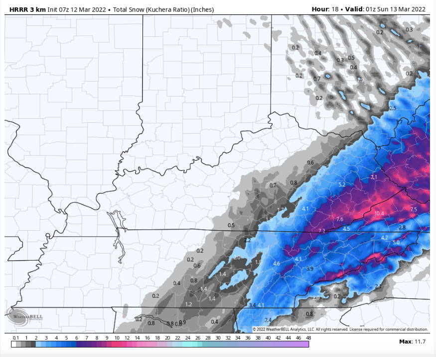
It is really coming down good right now. -
Mesoscale discussion for heavy snow is out from the SPC. 1-2” inch an hour rates.
-
4
-
-
Took a 2 hour nap to wake up to snow

-
5
-
-
Does the TIMS model apply if it is in Memphis during a snowstorm?!?
-
3
-
 2
2
-
-
Band of snow is quickly knocking at Memphis’ doorstep. Looks like no problem turning to snow there. High of 68 today. I still have my doubts for NETN and Scott County, VA snowhole that has been a big feature this year. I feel strongly that game is on for most of the Valley and Plateau. I hope everyone enjoys the snow.
It is the 29th anniversary of the Superstorm of 93. Something about March 12th.-
6
-
1
-
-
Y’all might want to check out the 0z GFS. Negative tilted trough……..

-
3
-
-
A really nice band moved through Louisville and it continuing southeast. I have no clue if it will stick together but there have been some special weather statements on it.
-
4
-


Hurricane Ian
in Tropical Headquarters
Posted
Stupid question here…. Does the shape of Cuba’s coastline help to tighten up Ian’s core in this situation? The outer bands of convection seems to line up very well with the southern coastline currently as they rotate counter clockwise parallel to the shore.