
1234snow
-
Posts
1,725 -
Joined
-
Last visited
Content Type
Profiles
Blogs
Forums
American Weather
Media Demo
Store
Gallery
Posts posted by 1234snow
-
-
Some things you don’t see in a SPC enhanced outlook too much: “Some larger population centers in the risk area includes: Johnson City, TN...Kingsport, TN...Bristol, TN...Morristown, TN...Bristol, VA...”
Also a 5% tornado area-
 1
1
-
-
This wind is no joke this afternoon! I see where Knoxville was reporting sustained winds of 40min with gusts to 63 earlier and while I don’t have an anemometer, I’d say it was close to that here. Seems like a High Wind warning would be more appropriate, but I know we don’t hardly get those here in the valley. A few weeks ago, and to some degree, this time, seems like the timing was off on the advisory/warning. The wInd this time though is every bit as strong as then if maybe not a little more, and only an advisory this time. I guess it’s not worth the trouble to upgrade?
I agree. The wind today was faster than the High Wind Warning day at least here.-
3
-
-
It is a rare event. Those types of wavelengths have my interest.
Snow is almost falling from Coast to coast (Oregon/Cali coast all the way the across the Rockies to the Midwest and to the northeast all the way to Massachusetts coast)if you look at radar. Certainly a configuration I don’t remember seeing.-
3
-
-
I’ve honestly not paid attention to soundings much before but I’ve noticed that on several models the modeled output is rain but the “best guess” precip type on the sounding is snow.
Has anyone else noticed this in past events and if the “best guess” on soundings have been accurate?-
3
-
-
The 0z HRRR has one incredible deformation band. Up to 3” of precip falls. Unfortunately it is modeled to be in the 40’s on the HRRR. About as painful to watch as it gets.
-
1
-
-
Out of my meeting. Did I miss anything?
You were totally looking at the Euro in your meeting! Lol.-
1
-
 2
2
-
-
I’ll take this and call it a winter! Lol-
8
-
 1
1
-
 1
1
-
-
Yep, that’s going into the Goofy Hall of Fame.
-
2
-
-
Light rain and 37 currently.
-
Little Sleet/snow shower in Kingsport
-
3
-
-
Time to fire up the 10 day lightning/thunder snow theory.
-
10
-
-
Nice little surprise here. Roads are now white and light snow falling. Temp is 24.
-
3
-
-
Mesoscale Discussion 2056 NWS Storm Prediction Center Norman OK 0315 PM CST Wed Dec 21 2022 Areas affected...southern Wyoming...southwest South Dakota...western Nebraska...and northern Colorado Concerning...Snow Squall Valid 212115Z - 220015Z SUMMARY...Snow squalls will persist into the evening across portions of the central Rockies and central High Plains. DISCUSSION...A very strong arctic front continues to move south across the central High Plains with temperature gradients of 40-50F along the front. Several bands of snow have developed near the vicinity of this front with moderate to heavy snow being observed. In addition, winds are very strong with 30-40 knot winds both north and south of the front with observed gusts in excess of 50 knots. These winds, combined with multiple bands of snow have led to snow squall conditions across much of Wyoming and southwest South Dakota this afternoon. These conditions continue to shift south with the surface front. Observed visibility restrictions have been greatest north of the front, likely due to drier snow amid temperatures in the -10 to -20F range and 30+ kt sustained winds. In fact, blizzard conditions have been observed at 8 ASOS/AWOS sites across Wyoming, South Dakota, and Nebraska in the past 2 hours. Expect similar conditions to spread into northern Colorado this evening.

I think this would qualify as a “Blue Norther”! Except for the whole country. In this map is a observation of 52 degrees in Colorado. Which will below 0 very shortly.
The 18z HRRR was very very cold Friday morning. It shows -15 up on Black Mountain on the KY/VA border. -10 or lower for the Plateau and SWVA. -3 around Chatty. -4 for Knoxville. -5 - -7 for TRI. Below 0 for the whole state.
I really hope the HRRR is about 10 degrees too cold for the whole state. But we have saw the cold be deeper behind these fronts in the past.-
6
-
-
The GFS finally caved that direction. It took baby steps every run. Hopefully the trend will stop and we can at least enjoy some backside flakes after the front comes through.
Even with the -NAO/-AO and emerging PNA we still have to get lucky for it to snow here these days. Unfortunately like mentioned above there is no 50/50 low or lower heights in the Atlantic Canada region. So the -NAO block really isn’t blocking anything.
I also think the little shortwave that comes through at the beginning of the week hurts us as well by allowing higher heights to build behind it.-
1
-
1
-
-
12z ICON with a similar wild shift. It also dumps the trough in the west and gets a low to Wisconsin. Wasn’t close to this solution on this run before.
Not being a Debby downer just relaying what I see that all 3 of the models so far (GFS, CMC ICON) have dug our TPV energy more into the western states. On the GFS it is perfect, on the other 2 it is cutter City.
I suspect the Euro will have a change as well to a deeper trough.-
1
-
-
The 12Z CMC came in wayyyyyyy different and dumps the trough in the west with no PNA ridge……. Then it cuts the low to Wisconsin and floods us with warm air/rain.
The run before it it held the 500 low not digging much at all. -
I think we are starting to switch from “Will there be a cold shot and East coast storm?” to “How far south can the TPV lope drop south and deepen?” Obviously it is still 7 days out at this point which is a long way in modeling but todays trends were good.
-
5
-
-
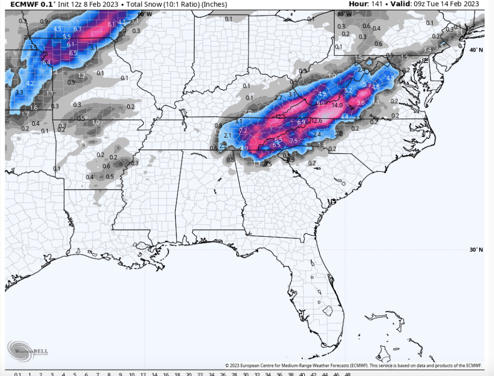
18z looks just like modeling did for the 2020 Christmas eve snow event. Those strips of heavier snow in an anafrontal situation. I've noticed it often models anafrontal snow that way but we tend to all get closer to equal amounts when it happens.
That is immediately the event I thought when I saw the the 18z GFS. Almost 2 years to the day as well. This one might be on crack though compared to that temp wise.-
3
-
-
Someone in the MA forum linked to this today. Some good insights into how the CPC folks see the pattern evolving:
https://www.cpc.ncep.noaa.gov/products/predictions/WK34/
For me, it was striking how much came down to La Nina probabilities. Not saying they are wrong to do that, but the whole write up was fascinating in terms of trying to see how the pros reason through medium to long range forecasting.
Some good MJO disco in there too.
This was well worth the read everyone. I’m going to start reading these discussions as they come out. Talks about how Atlantic wave breaking can keep the -NAO going longer, how the -PNA will break down and then come back later in the period, and how MJO may not influence the Asian jet where the convection is located.-
6
-
-
Good seeing you on here Gate City representative
 beeb awhile.
Thanks! I read the sub forum everyday and watch each round of model runs. I normally don’t say much because y’all do a wonderful job of breaking the pattern down.-
3
-
-
One thing I noticed on the 18z GFS and other model runs today (as well as ensembles) is the Greenland Block hangs on for most of the runs extended period. I believe that the block will be tough to break down completely as we head into the holidays. The longer the block holds the greater our chances. Surely one wave will hit. Right? Right? Lolz
-
8
-
-
My eyes may be playing tricks on me….. but if you look close you can see the actual flashes of lightning reflecting off other clouds in the eyewall.
-
1
-
-
Velocities of around 130mph are being shown from the Key west radar in the north and south quads of the storm. Appears to also show that the ERC is very close to complete.
-
18z HWRF completes the ERC soon, develops a big eye, and bombs Ian down to 928mb. I really hope that intensity is off. HMON is a more “reasonable” 939mb
-
1
-
Tn Valley Severe Weather
in Tennessee Valley
Posted
A few tornado warnings in Kentucky. One in Richmond, KY is a small cell but has a nice hook already.