buckeye
-
Posts
8,772 -
Joined
Content Type
Profiles
Blogs
Forums
American Weather
Media Demo
Store
Gallery
Everything posted by buckeye
-
gfs has 4 cutters over the next 2 weeks. That brings us to Feb 24th. Yes, this may be the worst collective winter forecasting failure that I can recall. It's like JB became a virus and it went epidemic in the meterology world. The only thing he has going for him is that this time he's not alone in failure. Don S., DT, HM, and a plethra of knowlegable mets on this site all crashed and burned. Per usual JB refuses to call it what it is and tries to piece together some kind of claim that his forecast was on target. It's reminiscent of his infamous "I nailed the pattern at 500mb", excuse. It's like watching someone try to build a tower out of jello while they convince you to keep watching just a little bit longer because it's almost there. He had Jan 20th thru Feb 15th as the pinnacle of winter's brutality, of course that was after the first half of January failed. When it became apparent that the PV visit was only going to be a glancing blow and mostly to our friends from Chicago on north, he immediately claimed that a rebound to warm for a few days was perfectly normal and expected, (even though he never said that beforehand). Now he has Feb 15th thru March 15th as his new target period for epic winter. That is now crumbling apart and frankly at this point I find it humorous... So why do you read him Buckeye? Because he's a hypster which leads to one of two outcomes. Either he's right and we snow....or he's wrong and turns into the clown building a tower out of jello. Either way it's entertainment
-
yea just horrible. Low pressure cuts for Michigan, than high pressure follows, than low pressure attacks the departing high and heads to Michigan again.... wash, rinse, repeat. Just bring me a torch....Feb, March 2012 sounds awesome right now.
-
I didn't know we had a storm to track lol.
-
I don't necessarily agree. I guess we'll have a good test coming up when the mjo starts taking the cold phases tour late next week. We'll see what real weather is doing.
-
Mods are all over the place days 4 -7. They can't even agree on what day has a storm much less what the track and strength is. I was surprised,to see the euro go warmer and more in the cutter direction since, it's the quickest to get the mjo into 8.
-
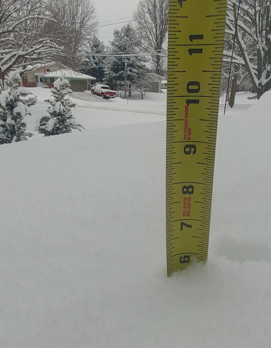
Was just outside, pretty close to 6" here. Biggest one of the season. Curious to see what Columbus airport comes in at.
-
Nice 4-6er
-
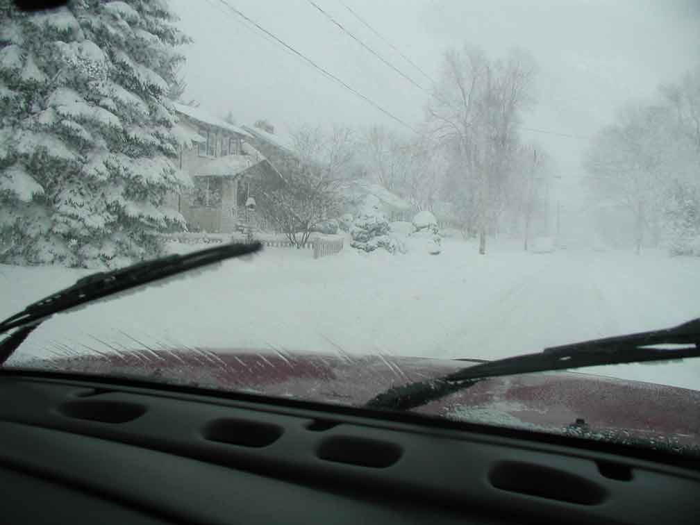
One of the reason I like an early spring and loathe a winter that refuses to completely give up....like last year. I love snow on snow....it's so rare though. Nothing like tracking the next event while you're in the midst of a warning level event. It seems like the big dogs tend to wash away within a few days. March'08 was the unicorn exception. Not only was it the largest snowfall in cmh history, it actually had better and longer staying power than most of our mid winter events. Speaking of March '08.... for old time sakes. I took this pic driving around during that storm in Westerville. sigh
-
...just sucks that it's bringing in a torch vs a cold wave.....but I would be the walking definition of ingrate if I poo-poo'd this one.
-
Thoughts about the clipper, - i-70 is bullseyed by most models wrt best snow - snow will be falling with very cold air and surface temps, which could open the door for a fluffy over-performer. On the flip side, such cold temps could end up turning this into a pixie blizzard too, which would hurt accums. - We'll have a nice 24-36 hr winter wonderland before the torch comes a knock'n. - I guess I'll take the grateful approach on this one. Assuming it doesn't find a way to fail, it's a snow event, which is why we're all here.
-
gfs says mid 50s-60 mon - wed. Unreal. After our quickly-doomed snowfall on thursday night.... we have 3 rainstorms in a row lined up to bat. Looks like rain will continue to rule our weather world as we roll into and through 2019, despite the pattern or time of year. Looks like after our 3 rainstorms, the next 2 storms go under us and are snowstorms for TN into the Carolinas
-
Kind of interesting because I don't recall ILN forecasting below zero temps through the afternoon. If that's the case, tonights low might beat forecasts. All of this with just a dusting of snow...just imagine if we had a deep snowcover.... we'd be sitting double digits below zero at noon
-
Temp continues to drop. I now have -6 as the sky clears up with bright sunshine. If this drop continues through the afternoon, we would be comparable to the 94 outbreak where afternoon temps were between -6 and -8.
-
ok i'm taking the bait... ....jb
-
So I left my driveway and it was 0 according to my truck. When I got to my office it was -3. What's impressive is it's actually windy out. Usually you get these cold shots like this and it's under strong HP that just settles in and everything is still.
-
Snow in front of the thaw Rain in front of the freeze It's how we roll
-
Yup, definitely could see that.
-
....screw this I'm moving to Philly....a REAL snow town!
-
Meh,,everything that can happen to mute or ruin a threat has happened this winter. Why expect that to change now.
-
So we have 2 cutters in front of the day 9 event. It is supposed to go south of us as the baroclinic boundary is pulled further south by the preceding 2 cutters. Im not holding my breath. Either we'll be licked by the wtod or the baroclinic boundary will be pulled further south and KY will get a snowstorm while we smoke cirrus.
-
You won't see me arguing against the duller version of outcomes this winter. Sounds good.
-
Thursday night/friday is a warm air advection set up. Those are another type of set up that can often lead to surprises.
-
Still holding out hope for a decent squall when the Arctic front moves thru tonight. Probably something the models aren't going to pick up on.
-
Don't ever recall a winter weather advisory where no precip was expected. Why wouldn't a wind chill warning cover things?