

buckeye
-
Posts
8,841 -
Joined
Content Type
Profiles
Blogs
Forums
American Weather
Media Demo
Store
Gallery
Everything posted by buckeye
-
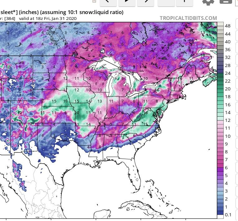
that's crazy....in a NORMAL winter, beginning of February, that right there would be blizzard for Indy. Today JB actually said if the MJO forecast verifies, (taking it out of the COD into the 4.5.6 tour schedule again), he was going to 'throw in the towel" on winter. Exact words. I never heard him say such a thing. Usually he goes down kicking and screaming and making things up to spin something, anything, out of nothing. Even the great meterological illusionist himself, can't save the weenies this winter. On this one he's right. MJO and EPO still look horrible. Our, (meaning I-70 crew), only hope is a perfectly timed sag in the boundary with a low moving up from the southern plains. Everything would have to be perfect...timing...strength of low, etc. Too strong and it goes to Chicago, too weak and it's a strung out rainer.
-
Agree. Even the torchy winters of past at least had the torching. This has been never-ending stretches of damp, gray, cold....just not cold enough for snow. Throw in the perpetual mirage of a 10day snowstorm on the models and it's more salt in the wound. I feel bad for the businesses who hope, if not count on, snow removal work. Just horrible all around. #nightmare-winter
-
wow.... can you imagine if that holds? I actually hope it does, that would be one of the most insane stats I can recall. I imagine that applies for a lot of locations in OH, IN, and possibly MI too.
-
Woke up to a few of the models showing a thread the needle, perfectly timed, potential snow(s) in the 7-10 day. Don't buy it folks! It's a head fake. Indices continue to suck as far as the eye can see. In fact some are trending even worse then they were. MJO travels from COD out into 6, raging +AO, +EPO, +NAO, -PNA. ***warning*** if JB talk offends you stop reading now. JB is now sounding like one of us. He showed some of the ens snow maps and actually said, "they've done this before and have been wrong all season, I don't trust them". Shocking coming from him. Looks like he's finally cried uncle to Old Man Winter
-
Yet another indicator of this miserable winter, Last year on this date, the "Let's Talk Winter" thread was 47 pages long Gotta admit, I kinda miss talking to the Ohio gang about incoming ...
-
When the months of December and January are a dumpster fire....the winter WILL suck regardless of what percentage of met winter we are through. It would take a FEB '10 combined with a March '08 to salvage the winter at this point.
-
Speaking of Cincy futility.....
-
....Never has Cincinnati had gone through a January without any snow since records began in 1872. If I lived in Cincy I'd be rooting for either a big dog or zilch....be a shame to ruin such an impressive futility record on a car topper.
-
Up to a couple of weeks ago, (although I was clearly not optimistic for a good winter), I at least felt we would probably get enough chances to scrape ourselves close to normal by early April. That hope is 100% gone and I think this could very well turn into a sub 12" winter. It now 'officially' has that feeling. I'm starting to think we might go from an above normal Feb to an all out Morch, (which I'd be fine with at this point). I know I bring up teleconnection indices a lot....but the truth is, they rarely let you down in spite of whatever the LR models are spitting out or Bustardi-style mets are trying to tell us using kelvin waves, strat warming, or the latest term of winter, (the Indian Ocean Dipole) lol. Look at the AO, NAO, PNA, EPO, and MJO....especially the MJO and EPO and those are way more telling as far as I'm concerned. That being said, the teleconnections are almost as bad as they can be. The AO, EPO, and NAO are all heading more positive than they currently are. The MJO is now going from a brief trip thru6 into 7 and then into the COD with overwhelming agreement of exiting the COD into the warm phases. I do think as we go through 7 late week, there is hope for another junk storm, maybe the one that is currently progged to be way north.....after that, it's back to garbageville and probably for most of the remaining winter.
-
I have NO doubt....
-
Over definitely. Like pondo said, we always find a way to scratch ourselves to near normal, and typically that happens in March and April. It'll be another forgettable winter though.
-
Now c'mon....March '08 was only 11 years ago
-
Definitely a top 5 winter event.for me. Heavy snow followed by a quarter inch of ice made for the most beautiful Christmas Eve and Day landscape ever. Of course not so much for the poor folks without electricity through the holidays.
-
Had the exact same thought when it came in last night....almost looked like fake snow. Big slow-falling flakes.
-
We have certainly become a cynical bunch here in central ohio...first winter headline of the season and cue the crickets .
-
Lest we forget, we live in Central Ohio.
-
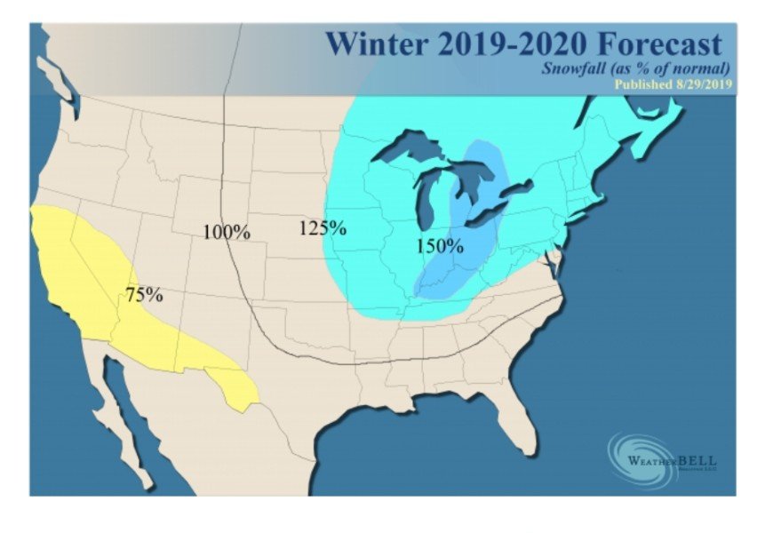
The euro weeklies thru the 24th of January has a snowfall mean for us of 8-10" I'm thinking it's 20-30 pennies, 8 -10 nickles, and a dime or 2.
-
Oh well, so much for consensus. Also. starting to look like a fairly boring...aka average...December setting up. Lots of dreary gray days with temps in the 30s and 40s. Probably a few post-cutter nickels and dimes as well. Actually glad to see the depth of these Arctic shots muting as lead time shortens. We're so back logged with work the last thing I need right now is the ground freezing up. Get us to December 24th and then crank up the snow machine!
-
all obvious caveats aside.... time of year, geography, and lead time.... ...there's a pretty impressive signal from the euro and gfs ensembles of an OV threat day 10. Notable because of the agreement across models this far out.
-
Agree, it's actually a pretty close to normal call for our area. This winter is looking pretty run of the mill. Would be nice to get one blockbuster event with a long lead up....something us folks in central ohio have not had in several winters. Otherwise it will end up in the overflowing file of forgotten winters.
-
Don has always done a nice job. I think last winter was his first bad bust since reading his winter outlooks over the years. In fairness lots of Mets went way too bullish last year with all the "winter of yore" calls. You never know, but I personally wouldn't bet on Don busting 2 in a row.
-
Amen... I checked and the 6z gfs has our first peek at Thanksgiving day and we're close to 60 degrees
-
Looks like a couple inches... Amazing similarities almost exactly 5 years ago to the day. So since everyone loves analogs, what was winter 14'-15' like?
-
someone needs to fix the lock... ...it doesn't seem to want to hold for very long. Oh well, it's about to lock-in again here in a few hours.
-
I don't know what it is about winters lately, but good ole fashioned cold and snowy Decembers are about as rare as a triple phaser anymore. Same thing with winters that end when they're suppose to rather than dragging into fricken April and May.


