

kayman
-
Posts
544 -
Joined
-
Last visited
Content Type
Profiles
Blogs
Forums
American Weather
Media Demo
Store
Gallery
Posts posted by kayman
-
-
-
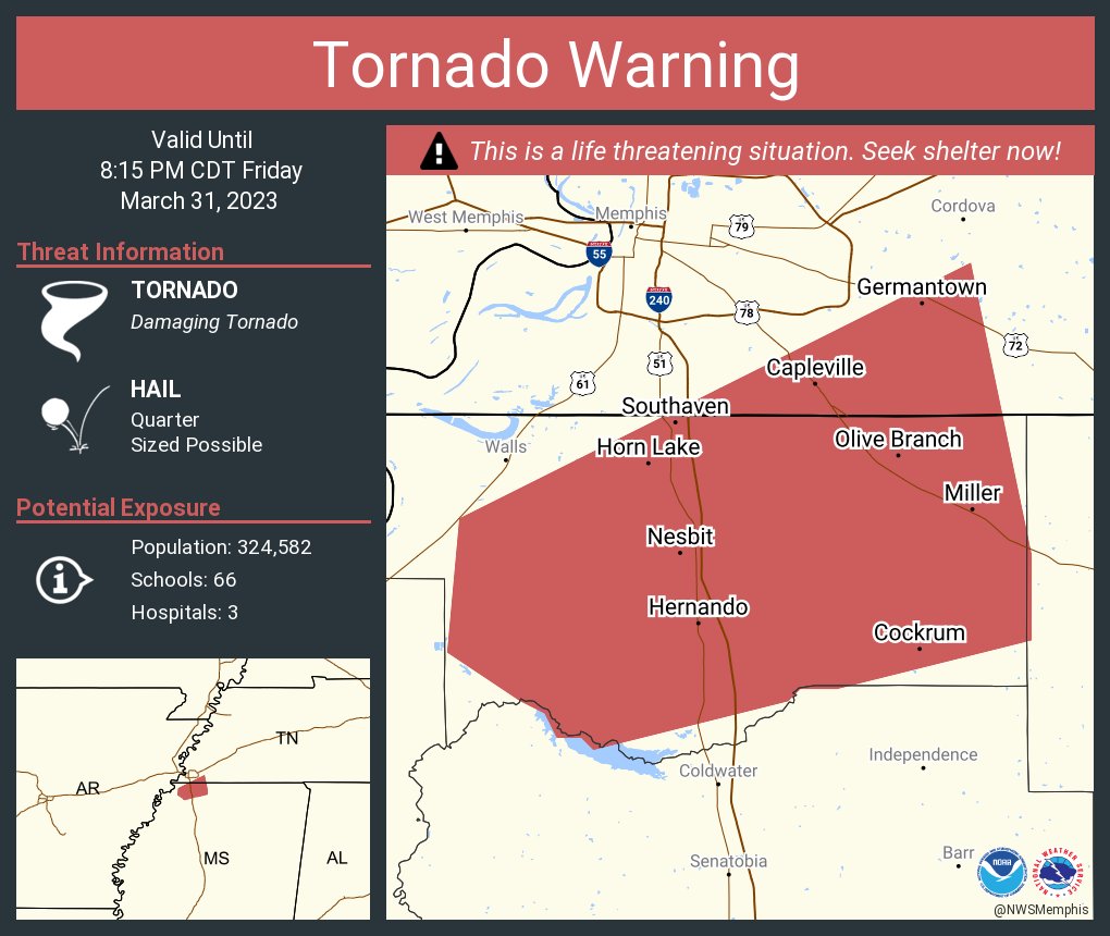
There's a debris ball in the CC with the storm as it goes through DeSoto County, MS near Hernando, MS
-
3 minutes ago, cheese007 said:
Brett Adair had it on stream for a bit
It's getting better organized as it's a moving into a conducive environment
-
TOG near Tunica, MS
-
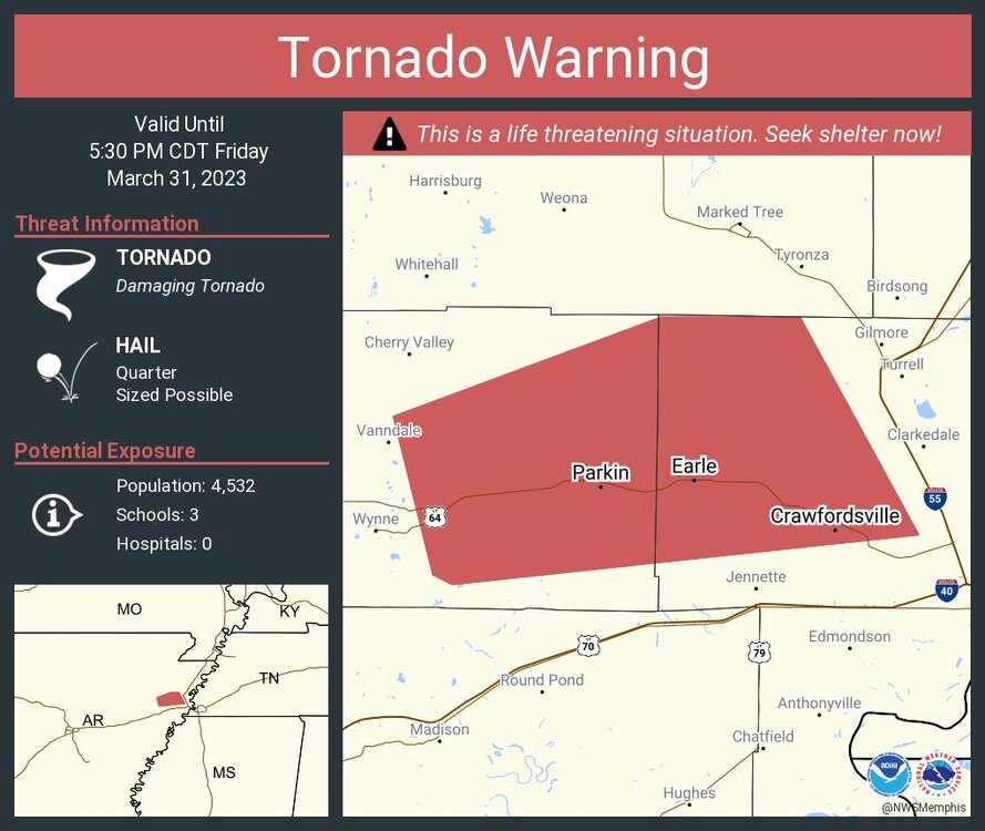
It's back on the ground in Tipton County in Covington per the Tipton County Sheriff
-
1 minute ago, weatherextreme said:
Twin tornadoes confirmed by the met
Both tornadoes are headed toward the north side of the metro Memphis area
-
TOG headed towards the northside of Metro Memphis
-
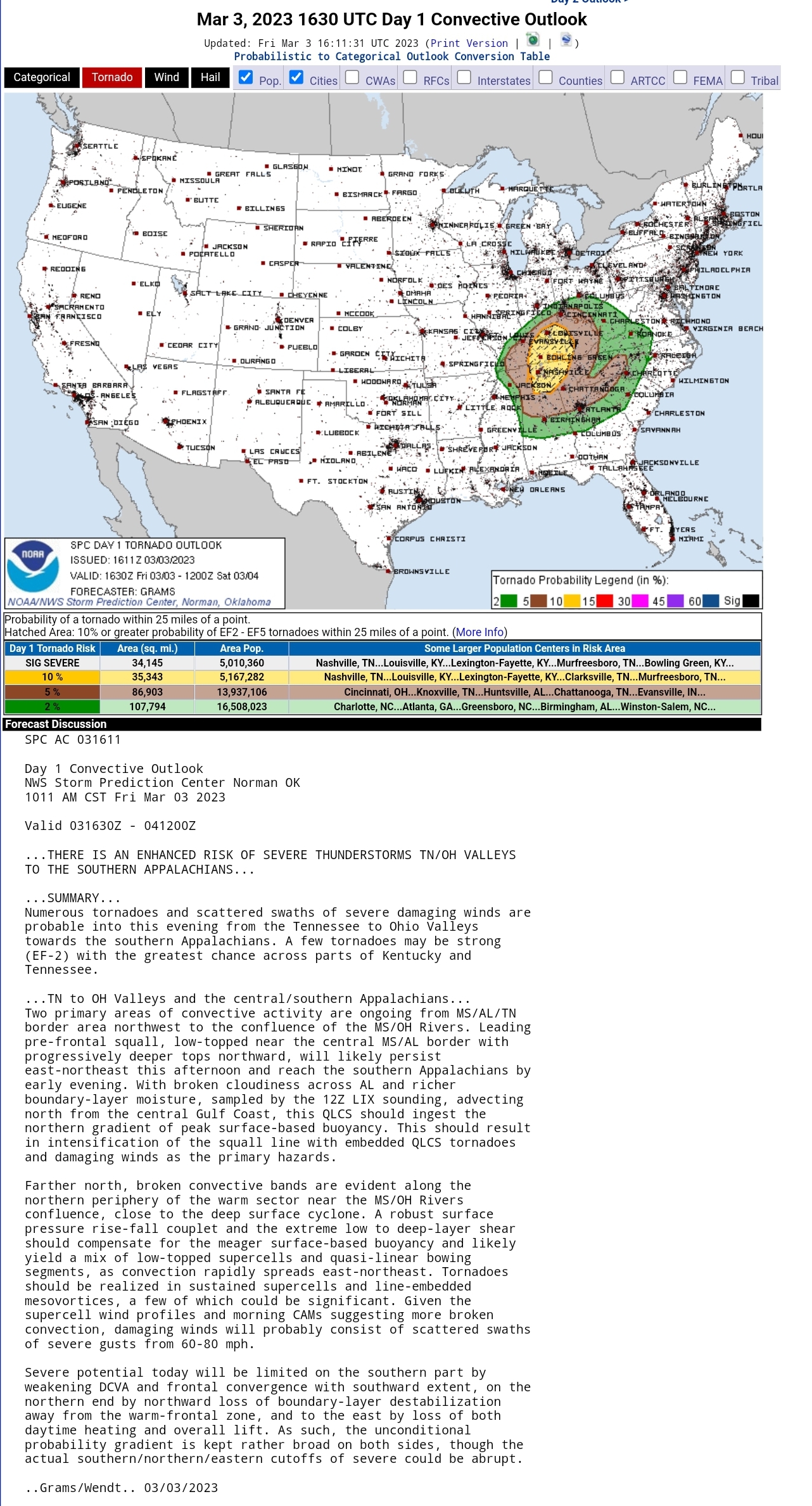
A thread on the ongoing threat of severe weather affecting most parts of the region from MS to the Carolinas.
https://www.spc.noaa.gov/products/outlook/day1otlk_2000_prt.html
https://www.spc.noaa.gov/products/outlook/day2otlk_1730_prt.html
We ought to watch this the threats including damaging winds and tornadoes because it affects MS and AL today through overnight hours. It could affect GA, SC, and NC tomorrow.
-
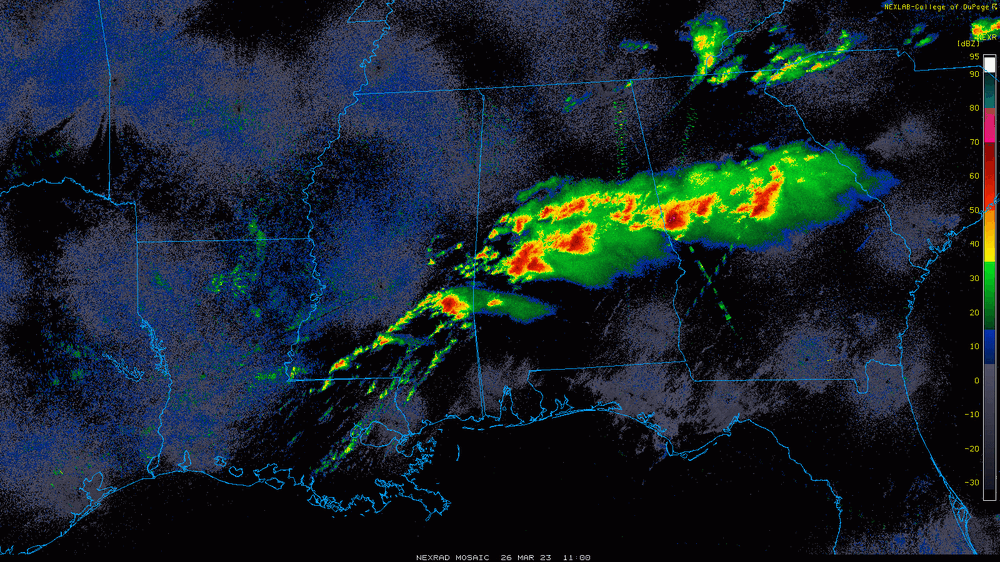
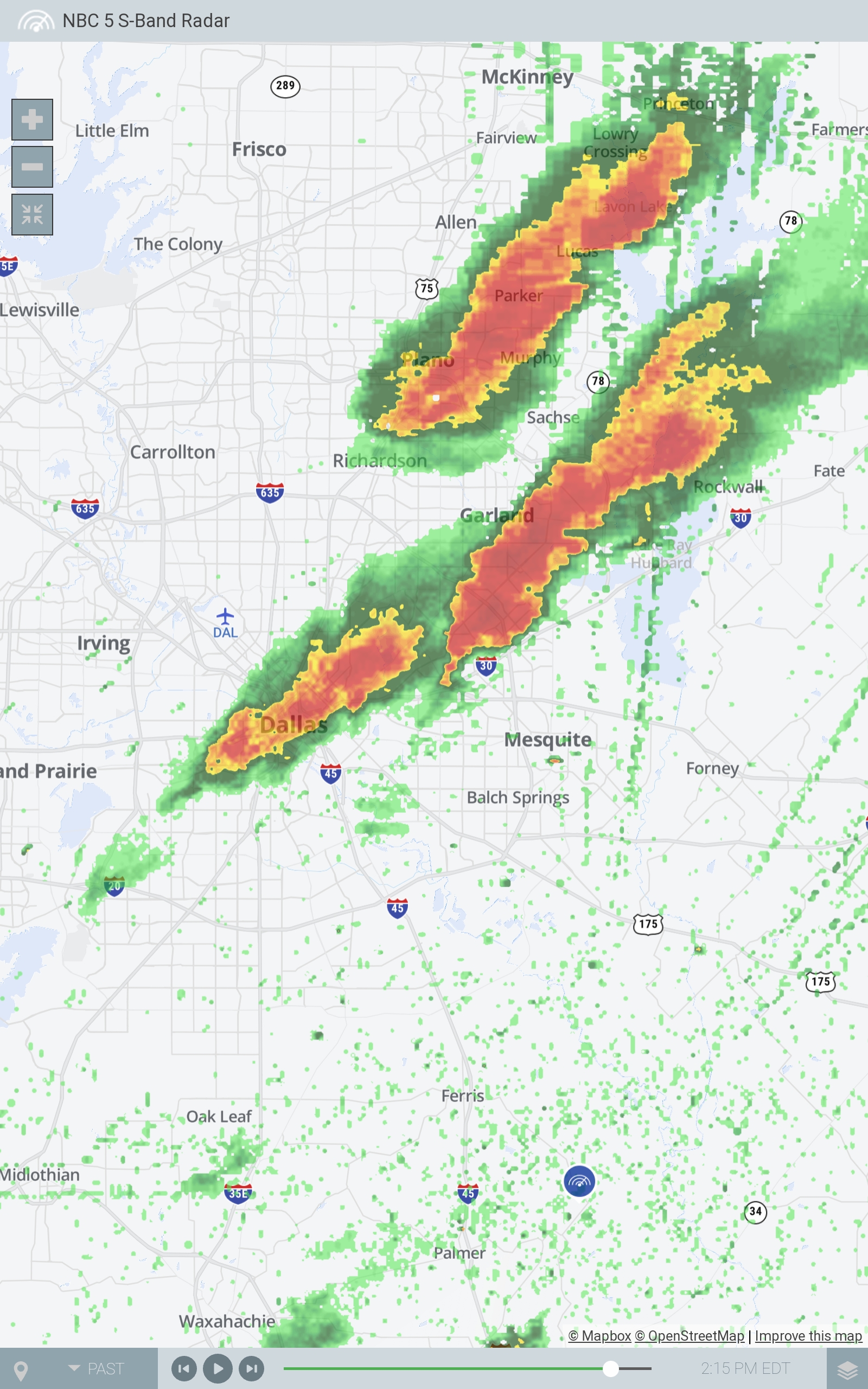
These storms are firing up on DFW, so the wind shear and helicity is very much there to the point that hook echoes are forming that fast west. Look at the cell with the initital hook above Mesquite. Courtesy of KXAS-TV NBC 5 S-Band Radar.

-
7 hours ago, Witness Protection Program said:
26 dead in a major tornado outbreak last week and I couldn't find a post, much less a thread, about it on the Southeastern board. Tenn Valley might work, but it seems like nearly all the tornado coverage in MS is a carryover from further west and thus a continuation of threads here. Might as well make official what has evolved in practice.
Nothing wrong with Carolina people focusing on the Carolinas, GA on GA, etc. But moving might clear up some confusion that may have limited posting when someone scanning couldn't find a thread or even activity in an event and didn't think to check the Central/Western States board (LOL). "Central/Western Time Zones Board"?
I agree. I'm originally from Birmingham and tries to post provide severe weather updates on the Southeast board. However, unless it pertaining to the Triangle (Raleigh/Durham/Chapel Hill) Fayetteville, or Eastern NC most posters on that board doesn't care. They tend to even ignore weather in Metro Atlanta in GA and Charlotte. If it's not snow, tropical storms, or hurricanes then they don't seem to care. I would say move everything from that not in the Triangle or Eastern portions of NC should be moved to a bigger Southeast board with AL, GA, MS, and the Tennessee Valley board all together.
-
 2
2
-
-
Quote
URGENT - IMMEDIATE BROADCAST REQUESTED
Tornado Watch Number 88
NWS Storm Prediction Center Norman OK
355 PM CDT Sun Mar 26 2023
The NWS Storm Prediction Center has issued a
* Tornado Watch for portions of
Far Eastern Louisiana
Southern and Central Mississippi
* Effective this Sunday afternoon and evening from 355 PM until
1100 PM CDT.
* Primary threats include...
Several tornadoes and a couple intense tornadoes likely
Scattered large hail likely with isolated very large hail events
to 3 inches in diameter possible
Scattered damaging wind gusts to 70 mph likely
SUMMARY...Supercell storms are expected to develop across and move
into southern and parts of central Mississippi this evening. Large
hail and damaging winds will be the main threats initially, but the
tornado potential should increase toward and after sunset, when
low-level shear will considerably increase. This includes the
potential for long-lived supercells and strong tornadoes (EF2+).
The tornado watch area is approximately along and 70 statute miles
north and south of a line from 10 miles west southwest of Natchez MS
to 35 miles south southeast of Meridian MS. For a complete depiction
of the watch see the associated watch outline update (WOUS64 KWNS
WOU8).
PRECAUTIONARY/PREPAREDNESS ACTIONS...
REMEMBER...A Tornado Watch means conditions are favorable for
tornadoes and severe thunderstorms in and close to the watch
area. Persons in these areas should be on the lookout for
threatening weather conditions and listen for later statements
and possible warnings.
&&
OTHER WATCH INFORMATION...CONTINUE...WW 86...WW 87...
AVIATION...Tornadoes and a few severe thunderstorms with hail
surface and aloft to 3 inches. Extreme turbulence and surface wind
gusts to 60 knots. A few cumulonimbi with maximum tops to 600. Mean
storm motion vector 26030.
...Guyer
Nocturnal tornadoes as tornadic risk increasing prevalent after dark... this is not good at all.
QuoteTornadoes
Probability of 2 or more tornadoes High (80%)
Probability of 1 or more strong (EF2-EF5) tornadoes Mod (60%)
Wind
HailProbability of 10 or more severe wind events High (70%)
Probability of 1 or more wind events > 65 knots Low (20%)
Combined Severe Hail/WindProbability of 10 or more severe hail events Mod (60%)
Probability of 1 or more hailstones > 2 inches Mod (50%)
Probability of 6 or more combined severe hail/wind events High (90%)
-
I feel like many have been underestimating the levels of MLCAPE values, low level shear, and helocity in the environment south of that stationary front. It's going to be a disturbing evening across those areas with the moderate & enhanced/hatched risk.
-
2 hours ago, purduewx80 said:
That's quite the early morning string of pearls across AL and GA. Two radar-confirmed tornadoes have occurred in GA over the past hour.
The one that was over west central Georgia was confirmed by the damage across Troup County, Georgia
PHOTOS: Tornado destroys multiple homes in Troup County: https://www.wsbtv.com/news/photos-tornado/K5NJ2HFEK5FZTFHQNTBQ7HTU5U
-
Damage is being reported with the areas under the aforementioned tornado warning per WSB-TV
-
Tornado Warning
GAC015-057-085-123-129-227-032045-
/O.NEW.KFFC.TO.W.0018.230303T2014Z-230303T2045Z/
BULLETIN - EAS ACTIVATION REQUESTED
Tornado Warning
National Weather Service Peachtree City GA
314 PM EST Fri Mar 3 2023
The National Weather Service in Peachtree City has issued a
* Tornado Warning for...
Northern Cherokee County in north central Georgia...
Southern Gilmer County in north central Georgia...
Northwestern Dawson County in north central Georgia...
Southeastern Gordon County in northwestern Georgia...
Pickens County in north central Georgia...
Northeastern Bartow County in northwestern Georgia...
* Until 345 PM EST.
* At 313 PM EST, severe thunderstorms capable of producing both
tornadoes and extensive straight line wind damage were located
near Ranger, or 10 miles east of Calhoun. Another area of rotation
was located 4 miles northwest of Pine Log. Both areas were moving
northeast at 60 mph.
HAZARD...Tornado and quarter size hail.
SOURCE...Radar indicated rotation.
IMPACT...Flying debris will be dangerous to those caught without
shelter. Mobile homes will be damaged or destroyed.
Damage to roofs, windows, and vehicles will occur. Tree
damage is likely.
* Locations impacted include...
Jasper, Ellijay, Nelson, East Ellijay, Talking Rock, Fairmount,
Ranger, Sequoyah Lake, Talona, Marblehill, Fausett Lake, Cartecay,
Salacoa Valley, Pisgah, Blaine, Lake Tamarack, Talmadge, Oakman,
Tate and Funkhouser.
PRECAUTIONARY/PREPAREDNESS ACTIONS...
TAKE COVER NOW! Move to a basement or an interior room on the lowest
floor of a sturdy building. Avoid windows. If you are outdoors, in a
mobile home, or in a vehicle, move to the closest substantial shelter
and protect yourself from flying debris.
Heavy rainfall may hide this tornado. Do not wait to see or hear the
tornado. TAKE COVER NOW!
&&
LAT...LON 3470 8426 3438 8426 3434 8481 3449 8483
3459 8468 3458 8468 3458 8465 3460 8465
3477 8440
TIME...MOT...LOC 2013Z 243DEG 52KT 3449 8476
TORNADO...RADAR INDICATED
MAX HAIL SIZE...1.00 IN
-
North Georgia is now under the gun for quick QLCS spin ups within the line.
-
30 minutes ago, nrgjeff said:
Nashville is just a hair east of the 10% hatched, and I agree. Lines up best with daytime heating going into afternoon. Also the Plateau elevation gives it better access to inflow wind. I don't normally share from EM briefings, but it's basically an adjusted 10% which is public on SPC. Please don't re-share though.
Chart is just the diurnal / daytime heating timing. One could drag the red line through Chattanooga and even into northwest Georgia. Don't forget Sand Mountain, AL which is another elevated area. Reasoning below.
Other considerations for more specific targets include North Georgia boundary (there as usual) and the Gulf moisture boundary lifting through Alabama. Both should get into Tennessee with a dynamic negatively tilted system (promotes lifting boundaries WF OFB or otherwise).
Either intersecting with the prefrontal trough PFT is an area of interest. Interesting with temps/dews the PFT is more quasi-dry line DL today. Anything like a DL always piques my interest in the South. On the other hand very fast storm motion might favor the porch chase.Another scenario is a more forced line with fewer sups. Would favor straight line wind, but it can be particularly strong by leveraging the background wind. High Wind Warning things.
I don't know about all that being accurate. Nashville is smack dab in the center of the 10% significant hatched in areas that came out in the past hour from the SPC. Louisville and Bowling Green are there too. The wind shear profiles and helocity values are going up right now and the storm bands are still at least an hour west of Greater Nashville. The lines are starting to break up into individual storms that are becoming more discrete.
-
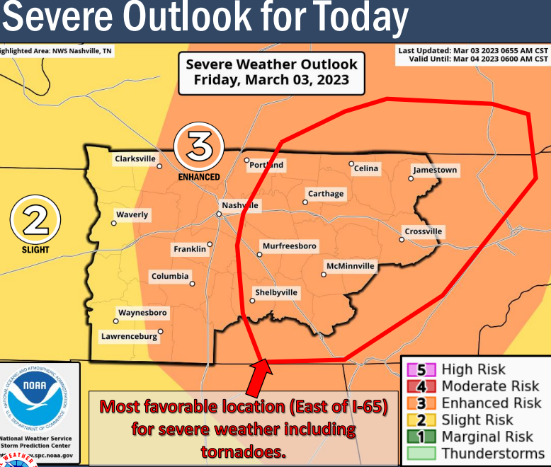
1 hour ago, Upstate Tiger said:
Severe threat still appears to be on schedule for Friday:
As of 225 PM EST Wednesday: A potent shortwave trough and closed
upper low will take on a negative tilt as it ejects out of the
Southern Plains Thursday night and lifts through the Tennessee
Valley and into Ohio on Friday. This will push a strong cold front
through the area that will bring a threat for severe thunderstorms.
A warm front will quickly lift north Thursday night into Friday
morning with the entire forecast area residing within an open warm
sector by the early afternoon hours. Upper 50s to low 60s dewpoints
will be common within the warm sector, which should be sufficient to
support 500-1500 J/kg of surface-based CAPE across the area with the
highest values across the Piedmont. This is concerning as shear
profiles will be quite impressive. A 50-60kt low-level jet
translating across Georgia and the Carolinas will help sweep out
large cyclonically curved hodographs with 400-500 m2/s2 of 0-1km SRH
and 40-45kts of 0-1km bulk shear. Deep-layer wind shear will also be
impressive on the order of 70-80kts. The resulting parameter space
will be more than supportive of all modes and hazards of severe
weather.

Details, however, will reside in the placement and magnitude of
forcing and where the best CAPE/shear balance sets up shop. A very
strong ~985mb surface low will lift into central Indiana with a pre-
frontal surface trough extending into northeast Georgia and the
Carolinas. While pressures will be low, the strongest surface
pressure falls and height falls aloft will be displaced just
northwest of the area. Early CAM/mesoscale guidance depicts a
scenario where forcing is just enough to instigate a cellular storm
mode while not being too strong for rapid upscale growth into a line
of convection. This solution would support a broken band of
supercells, which would yield a greater severe weather threat. The
other uncertainty is the CAPE/shear balance as warm mid-level
temperatures and poor lapse rates result in meager CAPE profiles.
Resulting updrafts could struggle with such a strong magnitude of
shear, but this could potentially be offset by stronger
forcing/kinematics. With that being said, the current slight risk
appears well placed across the area until details can get ironed
out. An upgrade to higher severe probabilities cannot be ruled out
either given the aforementioned parameter space. Winds will also be
gusty outside of the severe weather threat, especially during peak
heating/mixing within the warm sector. A high wind watch may
eventually be needed across the higher terrain in the mountains with
advisory level winds possible elsewhere.
There's already a thread on it:
https://www.americanwx.com/bb/topic/58949-march-3-severe-potential/
-
1
-
-
Quote
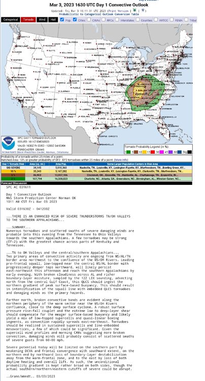
SPC AC 010829

   Day 3 Convective Outlook
   NWS Storm Prediction Center Norman OK
   0229 AM CST Wed Mar 01 2023

   Valid 031200Z - 041200Z

   ...THERE IS A SLIGHT RISK OF SEVERE THUNDERSTORMS ACROSS PARTS OF
   THE SOUTHEAST INTO THE OHIO VALLEY...

   ...SUMMARY...
   Severe thunderstorms capable of damaging wind gusts and a few
   tornadoes will be possible on Friday across parts of the Southeast
   into the Ohio Valley.

   ...Southeast into the Ohio Valley...
   A negatively tilted upper-level trough and attendant cyclone are
   forecast to move quickly from the Ozark Plateau toward the lower
   Great Lakes on Friday. A cold front will move across much of the
   Southeast and TN/OH Valleys. Very strong deep-layer flow/shear will
   overspread a relatively moist and at least weakly unstable
   environment from the Southeast into the Ohio Valley, resulting in a
   broad area of severe-thunderstorm potential.

   A strongly forced convective line is expected to be ongoing at the
   start of the period across central/eastern MS into western TN, with
   a threat of at least locally damaging wind and brief, line-embedded
   tornadoes. This line will progress across parts of middle/eastern TN
   into parts of the OH Valley, in conjunction with the strongest
   forcing associated with the ejecting shortwave trough. Instability
   will become increasingly scant with northeastward extent, but any
   steepening of low-level lapse rates that can occur ahead of the line
   will help to maintain a threat of damaging gusts and perhaps a
   line-embedded tornado or two, given very strong low-level flow/shear
   that will persist along/ahead of the surface low track.

   Farther south into parts of AL/GA and eventually the Carolinas,
   convective evolution is more uncertain. With the strongest forcing
   moving north of this region, some weakening of the convective line
   is possible, though somewhat stronger diurnal
   heating/destabilization (compared to areas farther north) may
   sustain sufficiently robust convection to maintain a threat of
   damaging wind and brief tornadoes through the afternoon into the
   evening, as convection spreads into the Carolinas.

   Some adjustments to the large Slight Risk will likely be needed in
   subsequent outlooks, depending on the timing of the ejecting
   shortwave trough and evolution of antecedent upstream convection
   during the Day 1-2 periods.

   ..Dean.. 03/01/2023
We ought to monitor the severe weather threat on 03/03/2023. The amount of bulk shear is there for Central Alabama (i.e., Greater Birmingham), North Georgia (i.e., Metro Atlanta). the Upstate (Greenville/Spartanburg/Anderson) and Midlands of South Carolina (Columbia), and Western North Carolina and Metro Charlotte to deal with damaging winds and a QLCS tornadic threat. I don't think this will make it to the Triangle, but the timing is key with the daytime heating. Also if there are any breaks in the cloud cover allowing more localized instability. The preliminary timing of the severe threat will be the midday and afternoon hours of Friday for said areas.
-
 1
1
-
-
80+ miles in length and confirmed EF-3
-
From The Weather Channel App: https://weather.com/storms/severe/video/drone-footage-from-selma-alabama-reveals-extent-of-tornado-damage?pl=pl-latest-forecasts
Tornadic damage in Selma is the catastrophic with whole neighborhoods destroyed
-
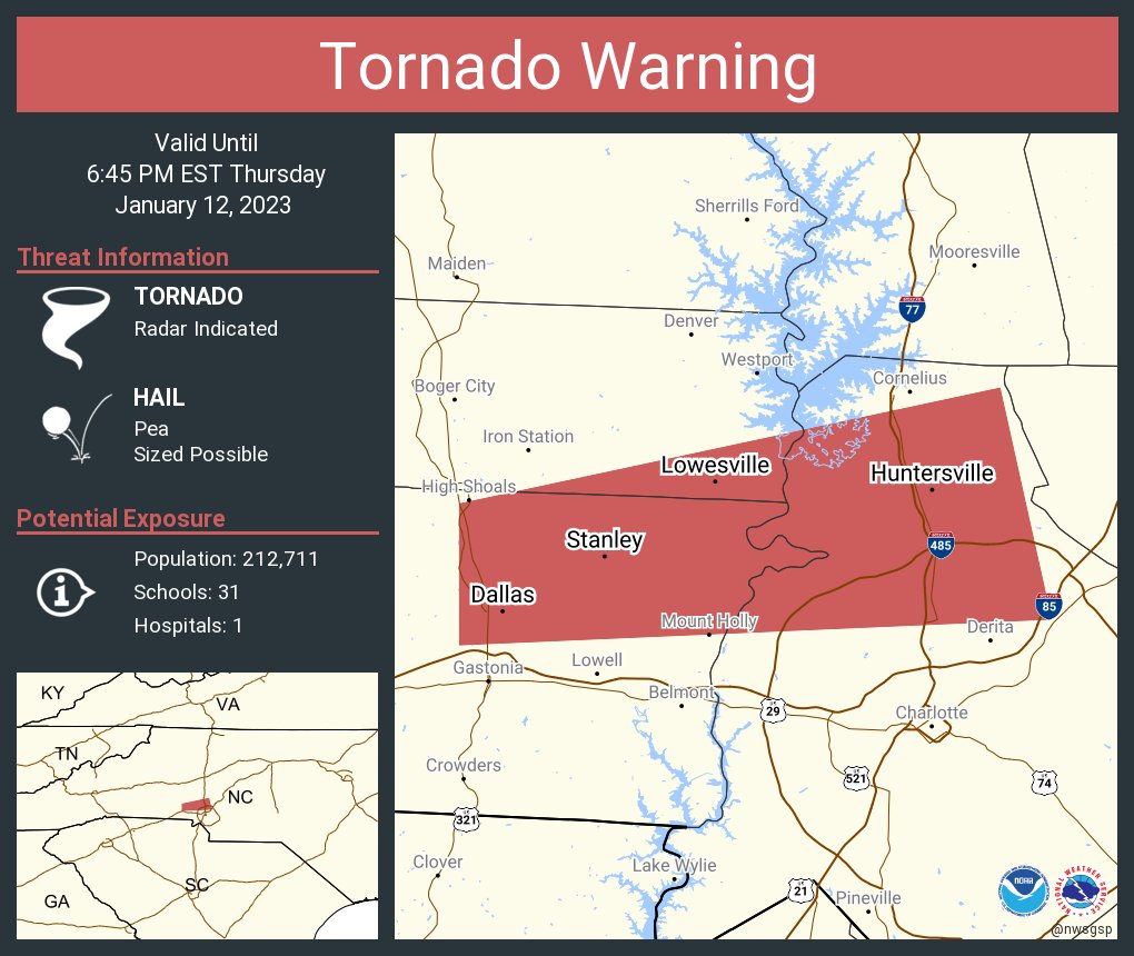
Tornado Warning for Lincoln, Gaston, and Mecklenburg counties in Metro Charlotte

-
1
-
-
-
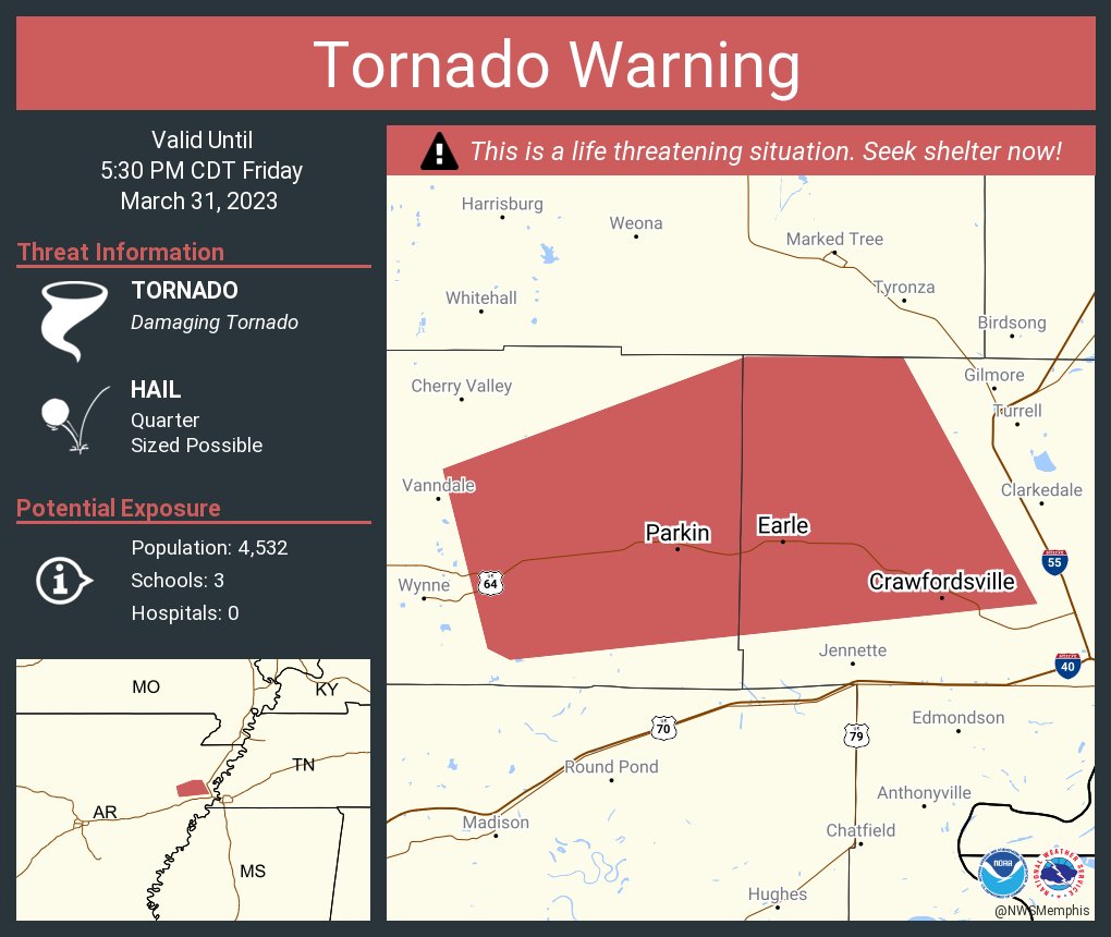
Severe Weather 3-30-23 and 3-31-23
in Central/Western States
Posted
Storm spotters saying there is a stove pipe, rain wrapped tornado on the ground in DeSoto County, MS