kayman
Members-
Posts
803 -
Joined
-
Last visited
Content Type
Profiles
Blogs
Forums
American Weather
Media Demo
Store
Gallery
Everything posted by kayman
-
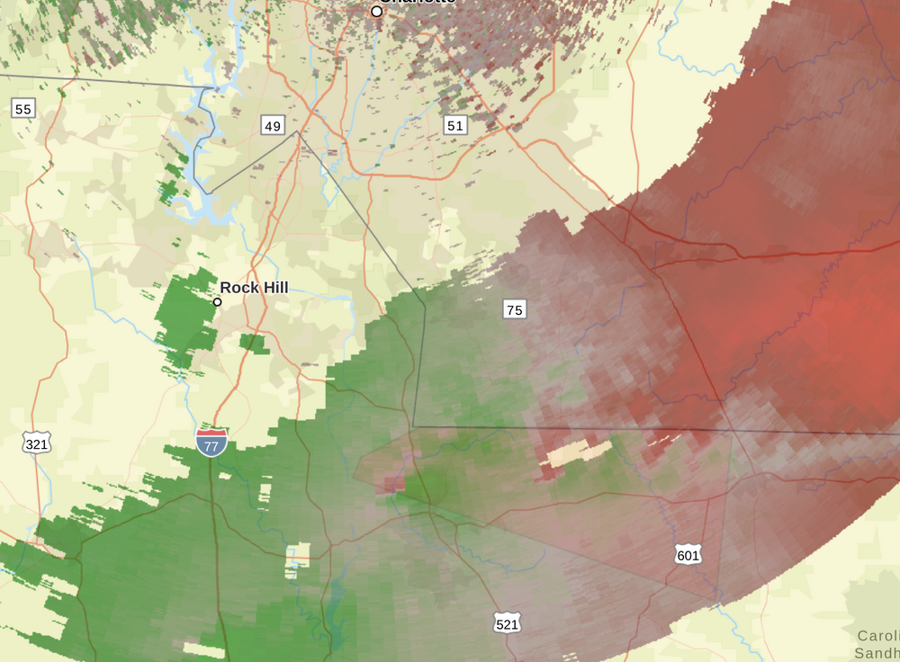
Severe Weather Statement National Weather Service Columbia SC 359 PM EDT Fri May 30 2025 SCC025-057-302015- /O.CON.KCAE.TO.W.0009.000000T0000Z-250530T2015Z/ Lancaster SC-Chesterfield SC- 359 PM EDT Fri May 30 2025 ...A TORNADO WARNING REMAINS IN EFFECT UNTIL 415 PM EDT FOR CENTRAL LANCASTER AND NORTHWESTERN CHESTERFIELD COUNTIES... At 359 PM EDT, a severe thunderstorm capable of producing a tornado was located near Buford, or 8 miles northeast of Lancaster, moving east at 35 mph. HAZARD...Tornado. SOURCE...Radar indicated rotation. IMPACT...Flying debris will be dangerous to those caught without shelter. Mobile homes will be damaged or destroyed. Damage to roofs, windows, and vehicles will occur. Tree damage is likely. This dangerous storm will be near... Buford around 405 PM EDT. Other locations impacted by this tornadic thunderstorm include Camp Creek Fire Station, Taxahaw, Unity Fire Station, Arrowood Estates, Tradesville, and High Point Fire Station. PRECAUTIONARY/PREPAREDNESS ACTIONS... TAKE COVER NOW! If you are outdoors, in a mobile home, or in a vehicle, move to an interior room or closet on the lowest floor of a sturdy building immediately. && LAT...LON 3482 8079 3482 8047 3481 8042 3465 8044 3477 8087 3479 8086 TIME...MOT...LOC 1959Z 276DEG 30KT 3480 8065 TORNADO...RADAR INDICATED MAX HAIL SIZE...<.75 IN $$ This is a tornado warning for Union County, NC, Lancaster County, and Chesterfield County, SC. Of course, the NWS doppler radar hole around Metro Charlotte is causing the velocity reflectivity to be very blurry. The CLT Terminal Doppler is severely limited in range of reflectivity.
-
URGENT - IMMEDIATE BROADCAST REQUESTED Tornado Watch Number 348 NWS Storm Prediction Center Norman OK 135 PM EDT Fri May 30 2025 The NWS Storm Prediction Center has issued a * Tornado Watch for portions of Northwest into Central North Carolina Western and Northern Virginia Southern and Eastern West Virginia * Effective this Friday afternoon and evening from 135 PM until 800 PM EDT. * Primary threats include... A couple tornadoes possible Scattered damaging wind gusts to 70 mph possible Isolated large hail events to 1.5 inches in diameter possible SUMMARY...Scattered thunderstorms are forecast to develop ahead of a surface low where enlarged hodographs and moist low levels will promote a mix of cells and bands of storms. The stronger storms will pose a risk for a couple of tornadoes, scattered damaging gusts, and isolated large hail. The tornado watch area is approximately along and 80 statute miles east and west of a line from 30 miles north northeast of Elkins WV to 20 miles southwest of Greensboro NC. For a complete depiction of the watch see the associated watch outline update (WOUS64 KWNS WOU8). PRECAUTIONARY/PREPAREDNESS ACTIONS... REMEMBER...A Tornado Watch means conditions are favorable for tornadoes and severe thunderstorms in and close to the watch area. Persons in these areas should be on the lookout for threatening weather conditions and listen for later statements and possible warnings. && OTHER WATCH INFORMATION...CONTINUE...WW 347... AVIATION...Tornadoes and a few severe thunderstorms with hail surface and aloft to 1.5 inches. Extreme turbulence and surface wind gusts to 60 knots. A few cumulonimbi with maximum tops to 500. Mean storm motion vector 25035. ...Smith
-
URGENT - IMMEDIATE BROADCAST REQUESTED Severe Thunderstorm Watch Number 347 NWS Storm Prediction Center Norman OK 1255 PM EDT Fri May 30 2025 The NWS Storm Prediction Center has issued a * Severe Thunderstorm Watch for portions of East-Central Alabama Northern into Central and Eastern Georgia Western North Carolina Western and Central South Carolina * Effective this Friday afternoon and evening from 1255 PM until 800 PM EDT. * Primary threats include... Widespread damaging wind gusts to 70 mph likely Isolated large hail events to 1.5 inches in diameter possible A tornado or two possible SUMMARY...A developing broken band of intensifying thunderstorms will quickly move across the Watch area this afternoon into the early evening. Severe gusts (60-70 mph) capable of wind damage will be the primary hazard. A brief tornado or two is possible in addition to an isolated risk for large hail. The severe thunderstorm watch area is approximately along and 115 statute miles east and west of a line from 35 miles east northeast of Hickory NC to 25 miles southeast of Columbus GA. For a complete depiction of the watch see the associated watch outline update (WOUS64 KWNS WOU7). PRECAUTIONARY/PREPAREDNESS ACTIONS... REMEMBER...A Severe Thunderstorm Watch means conditions are favorable for severe thunderstorms in and close to the watch area. Persons in these areas should be on the lookout for threatening weather conditions and listen for later statements and possible warnings. Severe thunderstorms can and occasionally do produce tornadoes. && AVIATION...A few severe thunderstorms with hail surface and aloft to 1.5 inches. Extreme turbulence and surface wind gusts to 60 knots. A few cumulonimbi with maximum tops to 500. Mean storm motion vector 27045. ...Smith
-
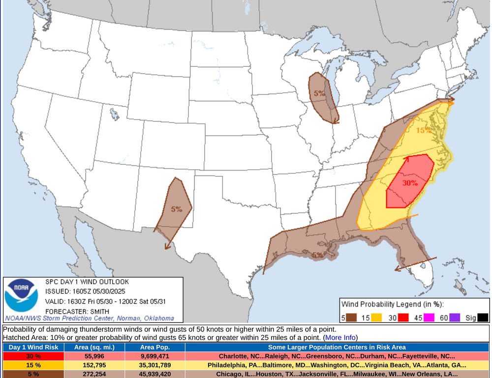
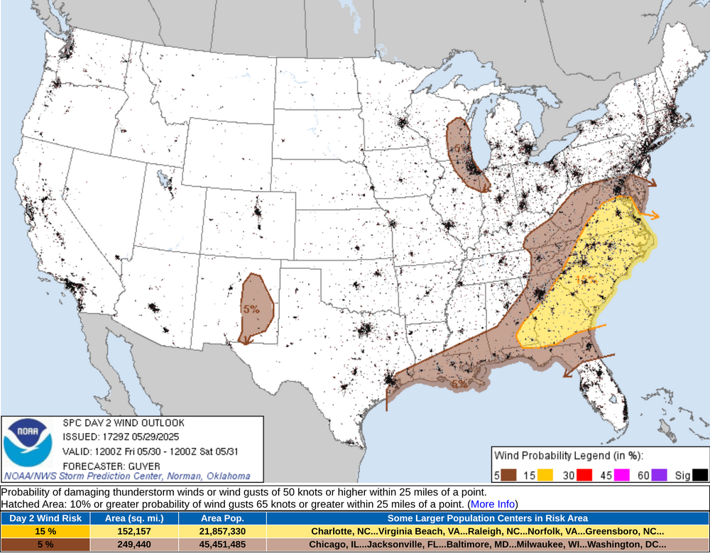
Charlotte, Raleigh/Durham, Greensboro, Columbia, Augusta, Savannah have an enhanced damaging wind threat today.
-
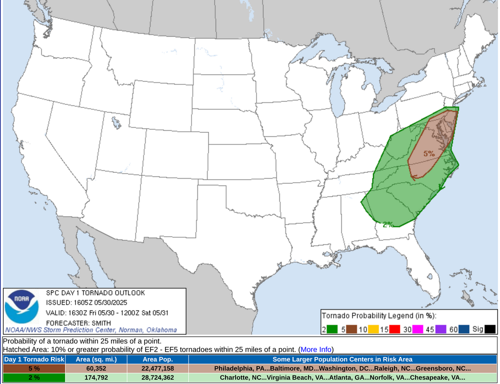
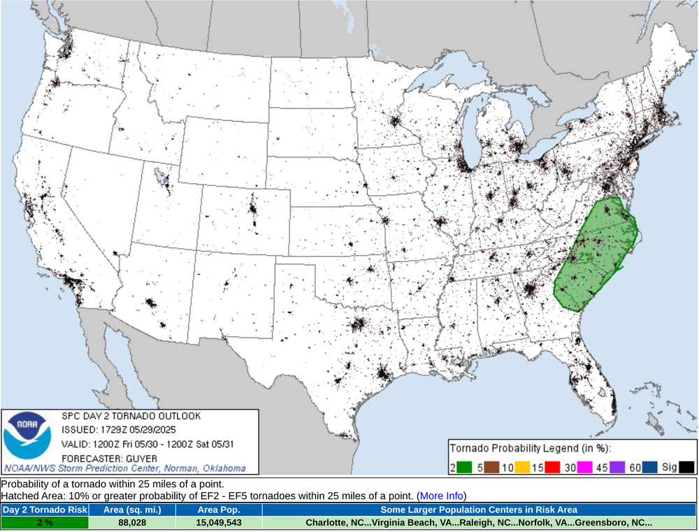
Raleigh/Durham, Richmond, Washington, and Baltimore might see more of threat of tornadic supercells or QLCS tornadic development
-
-
-
-
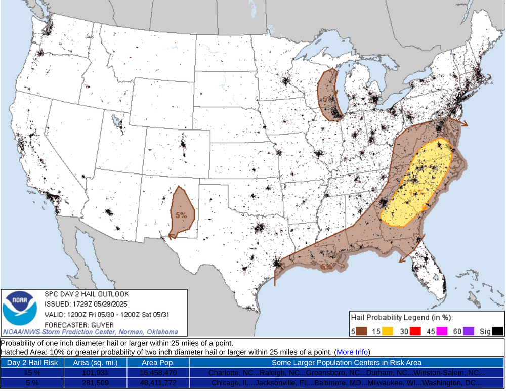
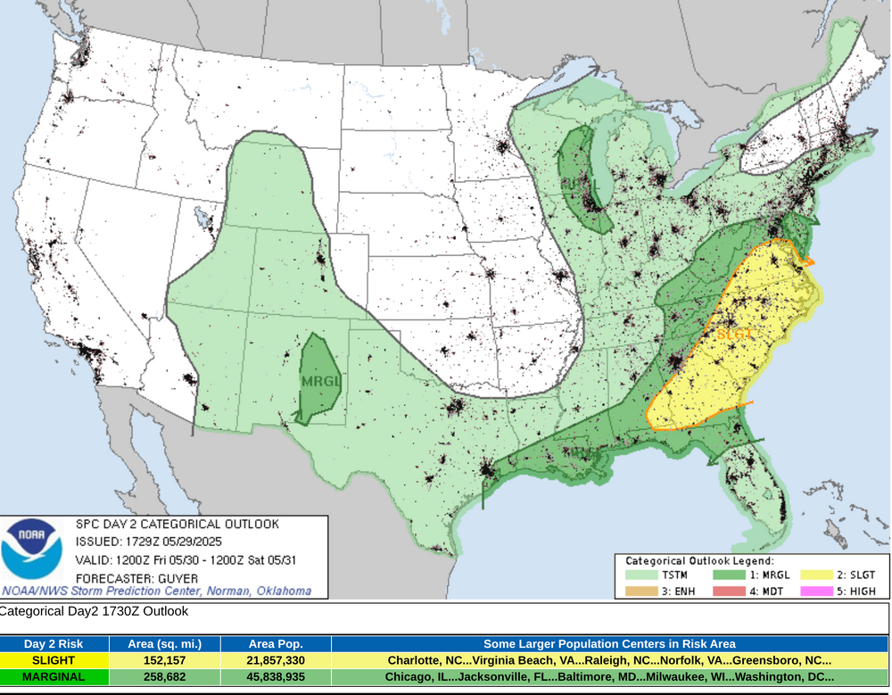
Here is the SPC forecast for May 30th, 2025 for Southeastern AL, FL Panhandle, GA, SC, NC, and VA with a potential upgrade in the severe potential SPC AC 291729 Day 2 Convective Outlook NWS Storm Prediction Center Norman OK 1229 PM CDT Thu May 29 2025 Valid 301200Z - 311200Z ...THERE IS A SLIGHT RISK OF SEVERE THUNDERSTORMS ACROSS THE CAROLINAS/MID-ATLANTIC/SOUTHEAST STATES... ...SUMMARY... Scattered severe storms with wind damage, large hail, and a couple tornadoes will be possible especially Friday afternoon and evening across the Mid-Atlantic/Southeast States. ...Carolinas/Mid-Atlantic/Southeast States... As large-scale pattern amplification occurs over the CONUS, a shortwave trough located over the lower Ohio River Valley early Friday morning, will steadily progress east-southeastward over the southern Appalachians and reach the Carolinas/Virginia by Friday evening. Strong winds aloft will accompany this shortwave trough with a belt of 60+ kt mid-level winds overspreading the southern Appalachians and Carolinas. While the warm sector preceding an east/southeastward-moving cold front will not be strongly unstable, particularly by late-spring standards, prevalent 60s F surface dewpoints, steepening mid-level lapse rates and strong deep-layer shear will support organized severe storms especially into Friday afternoon through early evening, including relatively fast-moving storms for late spring. While a few early day severe storms could occur across eastern Kentucky and nearby Allegheny Plateau/Appalachians, the main severe risk should begin to evolve in the immediate lee of the Appalachians including the Blue Ridge vicinity by Friday early/mid-afternoon. These storms, including some supercells and more prevalent evolving linear clusters with bowing segments, should reach coastal areas by early evening. Damaging winds and severe hail can be expected, and some tornado potential may exist as well, particularly across Virginia/North Carolina near the surface wave and warm front where low-level shear/SRH should maximize. ...Eastern Wisconsin/northern Illinois/Lake Michigan vicinity... A south/southeastward-digging clipper-type shortwave trough will influence the region into Friday afternoon and evening, with thunderstorms potentially focusing near a weak surface wave/instability gradient as a cold front otherwise progresses southward across the region. Low-level moisture will be rather modest with afternoon dewpoints generally limited to the lower 50s F. However, relatively steep lapse rates and moderately strong vertical shear, enhanced by 50+ northwesterly mid-level winds, should support strong/isolated severe storms Friday afternoon into evening, with hail and wind possible as storms progress south-southeastward. ...Eastern New Mexico... While the overall scenario will not be as severe storm-favorable as prior days, a couple of locally severe storms may occur Friday afternoon/early evening mainly near the higher terrain of east-central New Mexico. ..Guyer.. 05/29/2025
-
Severe Weather Statement National Weather Service Huntsville AL 915 PM CDT Tue May 20 2025 ALC049-071-210230- /O.CON.KHUN.TO.W.0051.000000T0000Z-250521T0230Z/ Jackson AL-DeKalb AL- 915 PM CDT Tue May 20 2025 ...A TORNADO WARNING REMAINS IN EFFECT UNTIL 930 PM CDT FOR SOUTHEASTERN JACKSON AND EAST CENTRAL DEKALB COUNTIES... At 914 PM CDT, a confirmed tornado was located near Henagar, or 7 miles north of Fort Payne, moving east at 35 mph. HAZARD...Damaging tornado and half dollar size hail. SOURCE...Law enforcement confirmed at least tornado between Sylvania and Henagar. IMPACT...Flying debris will be dangerous to those caught without shelter. Mobile homes will be damaged or destroyed. Damage to roofs, windows, and vehicles will occur. Tree damage is likely. This tornado will be near... Fort Payne around 920 PM CDT. Other locations impacted by this tornadic thunderstorm include Dutton, Desoto State Park, Valley Head, Mentone, Hammondville, and Pine Ridge. PRECAUTIONARY/PREPAREDNESS ACTIONS... To repeat, a tornado is on the ground. TAKE COVER NOW! Move to a basement or an interior room on the lowest floor of a sturdy building. Avoid windows. If you are outdoors, in a mobile home, or in a vehicle, move to the closest substantial shelter and protect yourself from flying debris. && LAT...LON 3451 8553 3450 8555 3450 8556 3449 8556 3448 8558 3447 8557 3447 8558 3443 8558 3449 8598 3463 8607 3467 8607 3469 8555 3454 8551 TIME...MOT...LOC 0214Z 270DEG 30KT 3457 8568 TORNADO...OBSERVED MAX HAIL SIZE...1.25 IN $$ KTW This is another in a series of long tracked supercells that are training through Jackson, Marshall, and Dekalb counties in northeast Alabama. The local law enforcement agencies in the area have confirmed a tornado is on the ground between Henager and Fort Payne moving towards I-59.
-
Severe Weather Statement National Weather Service Huntsville AL 850 PM CDT Tue May 20 2025 ALC049-071-210230- /O.CON.KHUN.TO.W.0051.000000T0000Z-250521T0230Z/ Jackson AL-DeKalb AL- 850 PM CDT Tue May 20 2025 ...A TORNADO WARNING REMAINS IN EFFECT UNTIL 930 PM CDT FOR SOUTHEASTERN JACKSON AND CENTRAL DEKALB COUNTIES... At 850 PM CDT, a confirmed tornado was located over Section, or 7 miles northwest of Rainsville, moving east at 35 mph. HAZARD...Damaging tornado and half dollar size hail. SOURCE...Broadcast media confirmed tornado. IMPACT...Flying debris will be dangerous to those caught without shelter. Mobile homes will be damaged or destroyed. Damage to roofs, windows, and vehicles will occur. Tree damage is likely. This tornado will be near... Sylvania, Powell, and Rainsville around 855 PM CDT. Henagar around 900 PM CDT. Fort Payne around 910 PM CDT. Other locations impacted by this tornadic thunderstorm include Dutton, Langston, Mentone, Desoto State Park, Valley Head, Hammondville, and Pine Ridge. PRECAUTIONARY/PREPAREDNESS ACTIONS... To repeat, a tornado is on the ground. TAKE COVER NOW! Move to a basement or an interior room on the lowest floor of a sturdy building. Avoid windows. If you are outdoors, in a mobile home, or in a vehicle, move to the closest substantial shelter and protect yourself from flying debris. && LAT...LON 3451 8553 3450 8555 3450 8556 3449 8556 3448 8558 3447 8557 3447 8558 3443 8558 3450 8609 3467 8607 3469 8555 3454 8551 TIME...MOT...LOC 0150Z 270DEG 30KT 3457 8593 TORNADO...OBSERVED MAX HAIL SIZE...1.25 IN $$
-
Severe Weather Statement National Weather Service Huntsville AL 822 PM CDT Tue May 20 2025 ALC049-071-095-210145- /O.CON.KHUN.TO.W.0048.000000T0000Z-250521T0145Z/ Marshall AL-Jackson AL-DeKalb AL- 822 PM CDT Tue May 20 2025 ...A TORNADO WARNING REMAINS IN EFFECT UNTIL 845 PM CDT FOR NORTHEASTERN MARSHALL...SOUTHERN JACKSON AND CENTRAL DEKALB COUNTIES... At 822 PM CDT, a confirmed tornado was located over Section, or 7 miles southeast of Scottsboro, moving east at 35 mph. HAZARD...Damaging tornado and golf ball size hail. SOURCE...Emergency management confirmed tornado. IMPACT...Flying debris will be dangerous to those caught without shelter. Mobile homes will be damaged or destroyed. Damage to roofs, windows, and vehicles will occur. Tree damage is likely. This tornado will be near... Rainsville, Henagar, Sylvania, and Powell around 830 PM CDT. Other locations impacted by this tornadic thunderstorm include Dutton, Langston, Paint Rock, and Pine Ridge. PRECAUTIONARY/PREPAREDNESS ACTIONS... To repeat, a tornado is on the ground. TAKE COVER NOW! Move to a basement or an interior room on the lowest floor of a sturdy building. Avoid windows. If you are outdoors, in a mobile home, or in a vehicle, move to the closest substantial shelter and protect yourself from flying debris. && LAT...LON 3452 8633 3456 8631 3457 8633 3458 8630 3459 8630 3460 8633 3466 8633 3470 8573 3445 8572 TIME...MOT...LOC 0122Z 268DEG 32KT 3459 8595 TORNADO...OBSERVED MAX HAIL SIZE...1.75 IN $$ KTW
-
The NWS Huntsville, Hytop NWS radar is down due to the severe weather. Any storms will have to be tracked via composite data from the NWS Birmingham, NWS Atlanta/Peachtree City radars.
-
Tornado Warning ALC071-089-103-210130- /O.NEW.KHUN.TO.W.0049.250521T0104Z-250521T0130Z/ BULLETIN - EAS ACTIVATION REQUESTED Tornado Warning National Weather Service Huntsville AL 804 PM CDT Tue May 20 2025 The National Weather Service in Huntsville Alabama has issued a * Tornado Warning for... Southwestern Jackson County in northeastern Alabama... Southeastern Madison County in north central Alabama... Northeastern Morgan County in north central Alabama... * Until 830 PM CDT. * At 804 PM CDT, a severe thunderstorm capable of producing a tornado was located near Redstone Arsenal, moving east at 45 mph. HAZARD...Tornado and quarter size hail. SOURCE...Radar indicated rotation. IMPACT...Flying debris will be dangerous to those caught without shelter. Mobile homes will be damaged or destroyed. Damage to roofs, windows, and vehicles will occur. Tree damage is likely. * This dangerous storm will be near... Owens Cross Roads and Huntsville around 810 PM CDT. Woodville around 820 PM CDT. Other locations impacted by this tornadic thunderstorm include Paint Rock, Garth, Hampton Cove, Laceys Spring, Farley, and Whitesburg. PRECAUTIONARY/PREPAREDNESS ACTIONS... TAKE COVER NOW! Move to a basement or an interior room on the lowest floor of a sturdy building. Avoid windows. If you are outdoors, in a mobile home, or in a vehicle, move to the closest substantial shelter and protect yourself from flying debris. && LAT...LON 3466 8628 3458 8631 3457 8633 3456 8631 3451 8633 3452 8639 3450 8639 3449 8642 3451 8654 3454 8655 3451 8656 3453 8667 3471 8667 3474 8627 TIME...MOT...LOC 0104Z 266DEG 38KT 3459 8659 TORNADO...RADAR INDICATED MAX HAIL SIZE...1.00 IN $$ GH
-
Two separate circulations in this other two supercells are near Lacey Springs and another one near Owens Crossroads respectively that are clearly looking very ominous and like both could put down tornadoes
-
New tornado debris signature and confirmed by local Jackson County 911 that it is on the ground Severe Weather Statement National Weather Service Huntsville AL 802 PM CDT Tue May 20 2025 ALC049-071-095-210145- /O.CON.KHUN.TO.W.0048.000000T0000Z-250521T0145Z/ Marshall AL-Jackson AL-DeKalb AL- 802 PM CDT Tue May 20 2025 ...A TORNADO WARNING REMAINS IN EFFECT UNTIL 845 PM CDT FOR NORTHEASTERN MARSHALL...SOUTHERN JACKSON AND CENTRAL DEKALB COUNTIES... At 801 PM CDT, a confirmed tornado was located near Grant, or 9 miles southwest of Scottsboro, moving east at 40 mph. HAZARD...Damaging tornado and ping pong ball size hail. SOURCE...Emergency management confirmed tornado. IMPACT...Flying debris will be dangerous to those caught without shelter. Mobile homes will be damaged or destroyed. Damage to roofs, windows, and vehicles will occur. Tree damage is likely. This tornado will be near... Scottsboro around 805 PM CDT. Section around 810 PM CDT. Powell around 820 PM CDT. Sylvania around 825 PM CDT. Henagar and Rainsville around 830 PM CDT. Other locations impacted by this tornadic thunderstorm include Dutton, Langston, Paint Rock, and Pine Ridge. PRECAUTIONARY/PREPAREDNESS ACTIONS... To repeat, a tornado is on the ground. TAKE COVER NOW! Move to a basement or an interior room on the lowest floor of a sturdy building. Avoid windows. If you are outdoors, in a mobile home, or in a vehicle, move to the closest substantial shelter and protect yourself from flying debris. && LAT...LON 3452 8633 3456 8631 3457 8633 3458 8630 3459 8630 3460 8633 3466 8633 3470 8573 3445 8572 TIME...MOT...LOC 0101Z 267DEG 34KT 3458 8618 TORNADO...OBSERVED MAX HAIL SIZE...1.50 IN $$ KTW
-
This supercell that just crossed the Tennessee River into southern Madison County, AL is likely having a tornado skipping back and forth above near Owens Crosssroads, Hampton Cove, and New Hope. It has shown a tornado debris signature multiple times in the past 10 minutes. Tornado Warning ALC071-089-095-103-210100- /O.NEW.KHUN.TO.W.0047.250521T0030Z-250521T0100Z/ BULLETIN - EAS ACTIVATION REQUESTED Tornado Warning National Weather Service Huntsville AL 730 PM CDT Tue May 20 2025 The National Weather Service in Huntsville Alabama has issued a * Tornado Warning for... Northwestern Marshall County in northeastern Alabama... West central Jackson County in northeastern Alabama... Southern Madison County in north central Alabama... East central Morgan County in north central Alabama... * Until 800 PM CDT. * At 730 PM CDT, a severe thunderstorm capable of producing a tornado was located near Morgan City, or near Redstone Arsenal, moving east at 30 mph. HAZARD...Tornado. SOURCE...Radar indicated rotation. IMPACT...Flying debris will be dangerous to those caught without shelter. Mobile homes will be damaged or destroyed. Damage to roofs, windows, and vehicles will occur. Tree damage is likely. * This dangerous storm will be near... Owens Cross Roads and Huntsville around 735 PM CDT. Other locations impacted by this tornadic thunderstorm include Paint Rock, Laceys Spring, Farley, Garth, Hampton Cove, Whitesburg, and Brownsboro. PRECAUTIONARY/PREPAREDNESS ACTIONS... TAKE COVER NOW! Move to a basement or an interior room on the lowest floor of a sturdy building. Avoid windows. If you are outdoors, in a mobile home, or in a vehicle, move to the closest substantial shelter and protect yourself from flying debris. && LAT...LON 3448 8666 3469 8668 3481 8626 3450 8625 TIME...MOT...LOC 0030Z 269DEG 28KT 3455 8659 TORNADO...RADAR INDICATED MAX HAIL SIZE...<.75 IN $$ KTW
-
There are 2 tornado debris signatures in Jackson County, AL with this supercell. Tornado Warning ALC049-071-TNC051-210100- /O.NEW.KHUN.TO.W.0046.250521T0021Z-250521T0100Z/ BULLETIN - EAS ACTIVATION REQUESTED Tornado Warning National Weather Service Huntsville AL 721 PM CDT Tue May 20 2025 The National Weather Service in Huntsville Alabama has issued a * Tornado Warning for... Jackson County in northeastern Alabama... Northeastern DeKalb County in northeastern Alabama... Southeastern Franklin County in Middle Tennessee... * Until 800 PM CDT. * At 721 PM CDT, a tornado producing storm was located near Skyline, or 10 miles northwest of Scottsboro, moving northeast at 40 mph. HAZARD...Damaging tornado. SOURCE...Radar confirmed tornado. IMPACT...Flying debris will be dangerous to those caught without shelter. Mobile homes will be damaged or destroyed. Damage to roofs, windows, and vehicles will occur. Tree damage is likely. * This tornadic storm will be near... Skyline around 725 PM CDT. Stevenson around 740 PM CDT. Bridgeport around 755 PM CDT. Other locations impacted by this tornadic thunderstorm include Bass, Martintown, Princeton, Lim Rock, Jericho, Russell Cave National Monument, Estillfork, Fackler, Hytop, and Anderson. PRECAUTIONARY/PREPAREDNESS ACTIONS... To repeat, a tornado is on the ground. TAKE COVER NOW! Move to a basement or an interior room on the lowest floor of a sturdy building. Avoid windows. If you are outdoors, in a mobile home, or in a vehicle, move to the closest substantial shelter and protect yourself from flying debris. && LAT...LON 3462 8627 3488 8629 3508 8586 3499 8586 3499 8573 3469 8557 TIME...MOT...LOC 0021Z 247DEG 36KT 3477 8616 TORNADO...OBSERVED MAX HAIL SIZE...<.75 IN $$ GH
-
This one has a debris ball on the Hytop (NWS Huntsville) radar. Tornado Warning Severe Weather Statement National Weather Service Huntsville AL 710 PM CDT Tue May 20 2025 ALC071-089-210030- /O.CON.KHUN.TO.W.0044.000000T0000Z-250521T0030Z/ Jackson AL-Madison AL- 710 PM CDT Tue May 20 2025 ...A TORNADO WARNING REMAINS IN EFFECT UNTIL 730 PM CDT FOR NORTHWESTERN JACKSON AND NORTHEASTERN MADISON COUNTIES... At 709 PM CDT, a confirmed tornado was located near New Market, or 7 miles east of Moores Mill, moving east at 30 mph. Debris signiture seen north of Gurley. HAZARD...Damaging tornado and two inch hail. SOURCE...Radar confirmed tornado. IMPACT...Flying debris will be dangerous to those caught without shelter. Mobile homes will be damaged or destroyed. Damage to roofs, windows, and vehicles will occur. Tree damage is likely. Locations impacted include... Maysville, Skyline, Princeton, Estillfork, Brownsboro, Larkin, Gurley, Pleasant Groves, Trenton, and Garth. PRECAUTIONARY/PREPAREDNESS ACTIONS... To repeat, a tornado is on the ground. TAKE COVER NOW! Move to a basement or an interior room on the lowest floor of a sturdy building. Avoid windows. If you are outdoors, in a mobile home, or in a vehicle, move to the closest substantial shelter and protect yourself from flying debris. && LAT...LON 3468 8653 3489 8648 3499 8617 3473 8609 TIME...MOT...LOC 0009Z 254DEG 26KT 3482 8639 TORNADO...OBSERVED MAX HAIL SIZE...2.00 IN $$ GH
-
Tornado Warning Tornado Warning ALC071-089-210030- /O.NEW.KHUN.TO.W.0044.250520T2344Z-250521T0030Z/ BULLETIN - EAS ACTIVATION REQUESTED Tornado Warning National Weather Service Huntsville AL 644 PM CDT Tue May 20 2025 The National Weather Service in Huntsville Alabama has issued a * Tornado Warning for... Northwestern Jackson County in northeastern Alabama... Central Madison County in north central Alabama... * Until 730 PM CDT. * At 644 PM CDT, a confirmed large and extremely dangerous tornado was located over University Of Alabama In Huntsville, or near Huntsville, moving east at 30 mph. This is a PARTICULARLY DANGEROUS SITUATION. TAKE COVER NOW! HAZARD...Damaging tornado. SOURCE...Emergency management confirmed tornado. IMPACT...You are in a life-threatening situation. Flying debris may be deadly to those caught without shelter. Mobile homes will be destroyed. Considerable damage to homes, businesses, and vehicles is likely and complete destruction is possible. * The tornado will be near... Alabama A And M University, Moores Mill, and Huntsville around 650 PM CDT. Other locations impacted by this tornadic thunderstorm include Maysville, Princeton, Estillfork, Pleasant Groves, Trenton, Garth, Ryland, Hollytree, Brownsboro, and Larkin. PRECAUTIONARY/PREPAREDNESS ACTIONS... To repeat, a large, extremely dangerous and potentially deadly tornado is on the ground. To protect your life, TAKE COVER NOW! Move to a basement or an interior room on the lowest floor of a sturdy building. Avoid windows. If you are outdoors, in a mobile home, or in a vehicle, move to the closest substantial shelter and protect yourself from flying debris. && LAT...LON 3465 8668 3482 8674 3499 8617 3473 8609 TIME...MOT...LOC 2344Z 254DEG 26KT 3476 8663 TORNADO...OBSERVED TORNADO DAMAGE THREAT...CONSIDERABLE MAX HAIL SIZE...2.00 IN $$ KTW
-
There is a large tornado on the ground in Madison County, AL near Madison right now headed towards the northside of Huntsville Tornado Warning 5/20/2025 19:24 EDT through 5/20/2025 19:45 EDT Tornado Warning issued May 20 at 6:24PM CDT until May 20 at 6:45PM CDT by NWS Huntsville AL ...A TORNADO WARNING REMAINS IN EFFECT UNTIL 645 PM CDT FOR SOUTHWESTERN MADISON AND SOUTHEASTERN LIMESTONE COUNTIES... At 622 PM CDT, a confirmed large and destructive tornado was located near Madison, moving east at 35 mph. TORNADO EMERGENCY FOR WESTERN MADISON AND EASTERN LIMESTONE COUNTY. This is a PARTICULARLY DANGEROUS SITUATION. TAKE COVER NOW! HAZARD...Deadly tornado. SOURCE...Radar confirmed tornado. IMPACT...You are in a life-threatening situation. Flying debris may be deadly to those caught without shelter. Mobile homes will be destroyed. Considerable damage to homes, businesses, and vehicles is likely and complete destruction is possible. The tornado will be near... Madison and Huntsville around 630 PM CDT. University Of Alabama In Huntsville and Redstone Arsenal around 635 PM CDT. Alabama A And M University around 645 PM CDT. Other locations impacted by this tornadic thunderstorm include Belle Mina, French Mill, Mooresville, Capshaw, Ryland, Hampton Cove, Ripley, Brownsboro, and Farley. Instructions To repeat, a large, extremely dangerous, and potentially deadly tornado is on the ground. To protect your life, TAKE COVER NOW! Move to an interior room on the lowest floor of a sturdy building. Avoid windows. If in a mobile home, a vehicle or outdoors, move to the closest substantial shelter and protect yourself from flying debris.
-
Severe Weather Statement National Weather Service Paducah KY 857 PM CDT Wed Apr 2 2025 INC051-147-163-173-KYC101-030245- /O.CON.KPAH.TO.W.0078.000000T0000Z-250403T0245Z/ Warrick IN-Vanderburgh IN-Spencer IN-Gibson IN-Henderson KY- 857 PM CDT Wed Apr 2 2025 ...A TORNADO WARNING REMAINS IN EFFECT UNTIL 945 PM CDT FOR WARRICK...VANDERBURGH...WEST CENTRAL SPENCER...SOUTHEASTERN GIBSON AND NORTHEASTERN HENDERSON COUNTIES... At 856 PM CDT, tornado producing storms were located along a line extending from near Kasson to Evansville to near Henderson, moving northeast at 75 mph. HAZARD...Damaging tornado. SOURCE...Radar confirmed tornado. IMPACT...Flying debris will be dangerous to those caught without shelter. Mobile homes will be damaged or destroyed. Damage to roofs, windows, and vehicles will occur. Tree damage is likely. These tornadic storms will be near... Newburgh, Melody Hill, Darmstadt, Chandler, Henderson, and Evansville around 900 PM CDT. Boonville around 905 PM CDT. Lynnville around 910 PM CDT. Folsomville around 915 PM CDT. Other locations impacted by these tornadic storms include Elberfeld and Tennyson. This includes the following highways... Interstate 69 in Indiana between Mile Markers 1 and 23. Interstate 64 in Indiana between Mile Markers 27 and 52. PRECAUTIONARY/PREPAREDNESS ACTIONS... To repeat, a tornado is on the ground. TAKE COVER NOW! Move to a basement or an interior room on the lowest floor of a sturdy building. Avoid windows. If you are outdoors, in a mobile home, or in a vehicle, move to the closest substantial shelter and protect yourself from flying debris. Tornadoes are extremely difficult to see and confirm at night. Do not wait to see or hear the tornado. TAKE COVER NOW! && LAT...LON 3802 8711 3790 8738 3782 8767 3783 8767 3795 8764 3802 8770 3805 8770 3820 8748 3821 8746 3821 8708 3820 8706 TIME...MOT...LOC 0156Z 238DEG 63KT 3806 8763 3799 8757 3788 8760 TORNADO...OBSERVED MAX HAIL SIZE...<.75 IN $$ DWS
-
Severe Weather Statement National Weather Service Paducah KY 906 PM CDT Wed Apr 2 2025 KYC033-055-143-030230- /O.CON.KPAH.TO.W.0075.000000T0000Z-250403T0230Z/ Crittenden KY-Caldwell KY-Lyon KY- 906 PM CDT Wed Apr 2 2025 ...A TORNADO WARNING REMAINS IN EFFECT UNTIL 930 PM CDT FOR SOUTH CENTRAL CRITTENDEN...NORTHWESTERN CALDWELL AND NORTH CENTRAL LYON COUNTIES... At 906 PM CDT, a confirmed tornado was located near Eddyville, moving northeast at 55 mph. HAZARD...Damaging tornado. SOURCE...Weather spotters confirmed tornado. IMPACT...Flying debris will be dangerous to those caught without shelter. Mobile homes will be damaged or destroyed. Damage to roofs, windows, and vehicles will occur. Tree damage is likely. This tornado will be near... Creswell and Farmersville around 910 PM CDT. Other locations impacted by this tornadic thunderstorm include Fredonia. This includes Interstate 69 in Kentucky between Mile Markers 71 and 73. PRECAUTIONARY/PREPAREDNESS ACTIONS... To repeat, a tornado is on the ground. TAKE COVER NOW! Move to a basement or an interior room on the lowest floor of a sturdy building. Avoid windows. If you are outdoors, in a mobile home, or in a vehicle, move to the closest substantial shelter and protect yourself from flying debris. && LAT...LON 3722 8820 3736 8799 3718 8782 3714 8791 3708 8809 TIME...MOT...LOC 0206Z 239DEG 49KT 3716 8804 TORNADO...OBSERVED MAX HAIL SIZE...<.75 IN $$ JGG
-
CC on the Indianapolis NWS with a debris signature headed towards Ball State University Severe Weather Statement National Weather Service Indianapolis IN 1002 PM EDT Wed Apr 2 2025 INC035-095-030215- /O.CON.KIND.TO.W.0026.000000T0000Z-250403T0215Z/ Madison IN-Delaware IN- 1002 PM EDT Wed Apr 2 2025 ...A TORNADO WARNING REMAINS IN EFFECT UNTIL 1015 PM EDT FOR NORTHERN MADISON AND DELAWARE COUNTIES... At 1002 PM EDT, a confirmed tornado was located 7 miles south of Matthews, or 8 miles northwest of Muncie, moving northeast at 70 mph. HAZARD...Damaging tornado. SOURCE...Radar confirmed tornado. IMPACT...Flying debris will be dangerous to those caught without shelter. Mobile homes will be damaged or destroyed. Damage to roofs, windows, and vehicles will occur. Tree damage is likely. Locations impacted include... Orestes, Eaton, Ball State University, Selma, Summitville, Gaston, Muncie, Daleville, Alexandria, Albany, Yorktown, Frankton, and Chesterfield. This includes Interstate 69 between mile markers 233 and 252. PRECAUTIONARY/PREPAREDNESS ACTIONS... To repeat, a tornado is on the ground. TAKE COVER NOW! Move to a basement or an interior room on the lowest floor of a sturdy building. Avoid windows. If you are outdoors, in a mobile home, or in a vehicle, move to the closest substantial shelter and protect yourself from flying debris. && LAT...LON 4009 8555 4025 8582 4038 8576 4038 8534 4030 8522 4020 8522 TIME...MOT...LOC 0202Z 236DEG 61KT 4028 8551 TORNADO...OBSERVED MAX HAIL SIZE...<.75 IN $$ Updike
-
I was talking about this bookend vortex aka commahead via the Indianapolis NWS radar & velocity that moved through I-465 beltway around Indianapolis on the Lake/Midwest regional forum.

