

BullCityWx
-
Posts
8,892 -
Joined
-
Last visited
Content Type
Profiles
Blogs
Forums
American Weather
Media Demo
Store
Gallery
Posts posted by BullCityWx
-
-
2 minutes ago, Leesville Wx Hawk said:
Light snow falling in Chapel Hill via weather cam so it will start here soon.
Nothing here at present
-
The NAM tonight had a very interesting band in Orange County on Monday. Actually, I guess it was the second run in a row for roughly that same location. Someone is gonna sneak out another inch or two Monday, just gotta hope the slot machine lines up.
-
 1
1
-
-
I wish we had someone in Hillsborough for ground truth.
-
1 hour ago, FLweather said:
The only bright side is I do see the possibility of Token flakes as the ULL swings through on the 1st.
That's for the piedmont of NC. Should be a good NWF event for the mountains.
Agreed
-
1
-
-
My nephew texted me and said it’s snowing in Gastonia.
-
We hit 18.4 last night. Up to 34 now.
-
GFS gave me a bit more than an inch tomorrow night.
-
15 minutes ago, BornAgain13 said:
DT's 1st guess Map... got me in 4-8" , would love that but I don't think we get that high , maybe 2-4" before the change to ICE
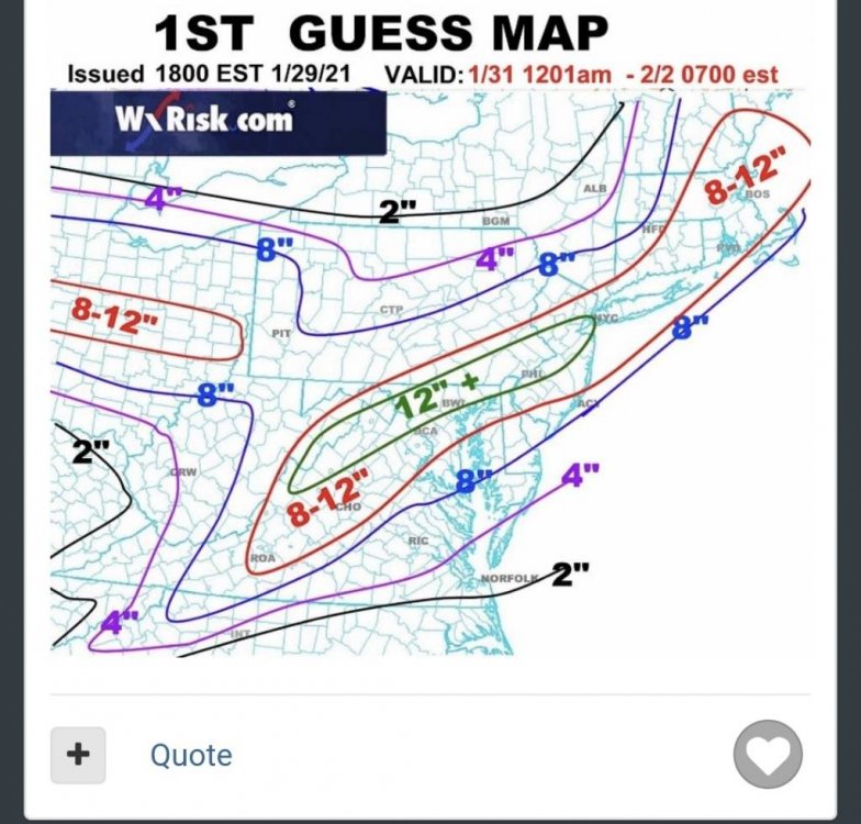
Sent from my SM-N981U using Tapatalk
2” mile just 10 miles north of me. I doubt that.
-
 1
1
-
-
3k NAM is about to be a big freezing rain event pretty far south.
-
The HRRR has a lot of....sleet here?

-
1
-
-
The euro still likes the idea of snow for Monday for the 40/85 corridor from Greensboro to Durham.
-
Just now, Leesville Wx Hawk said:
What do you see back-side Bull City for the Bull City? Are you talking Monday evening or so? There is a shot at a dusting tomorrow evening that saw earlier.
Yeah, it looks like it actually backs into the northern areas of the triangle and triad.
-
Just now, Buddy1987 said:
 Ukie looks good! @BornAgain13 hopefully you can cash in before flipping.
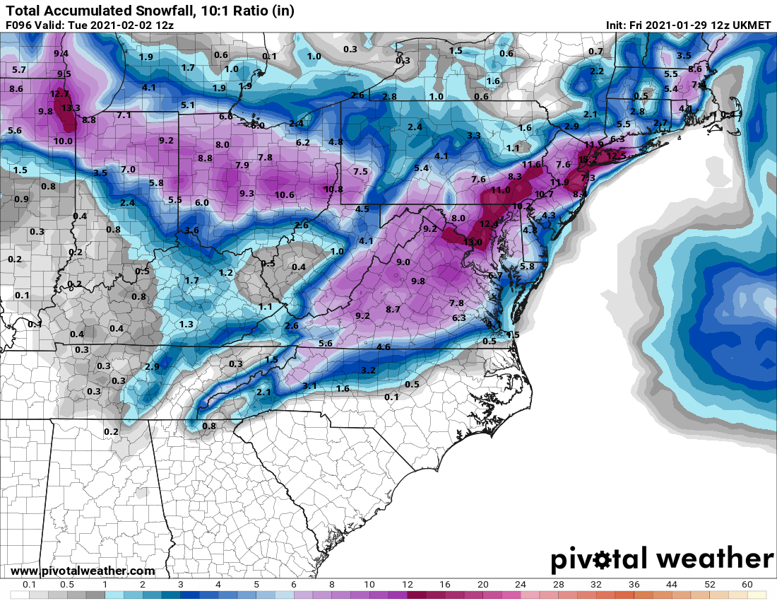
There's something off about those maps. It has to be including everything frozen/freezing. The maps on F5 look nothing like that.
-
1 minute ago, BullCityWx said:
I hate to say it but I am beginning to believe I was right about my gut feeling about this storm earlier this week. It's an absolute non-event for 90% of North Carolinians and that might even be creeping into the border counties of VA. Pretty much the only model currently showing a significant event for us is the RGEM.
I should qualify that with I think we actually have a better than average snow on the back side of this event.
-
I hate to say it but I am beginning to believe I was right about my gut feeling about this storm earlier this week. It's an absolute non-event for 90% of North Carolinians and that might even be creeping into the border counties of VA. Pretty much the only model currently showing a significant event for us is the RGEM.
-
Through Hour 48.
.thumb.png.2fbade721e10133e506c63c6c8cbb871.png)
-
24 minutes ago, FLweather said:
Hey how much did y'all get in Person county with the last storm?
I saw a guy in the discusion thread say he got 5". I think he was in the Timberlake or S. Roxboro area.
-
1
-
-
Just now, FLweather said:
That run looks funny to me.
3-4"+ of rain along the NC/VA border. With a inch + of ice.
Looking at Nam & Wrf.
The CAD might be colder and deeper than what the models are picking up atm.
One thing I am noticing between the two. Is the parent HP is well into Canada. But there is a strong ridge axis extending well south.
So there is a possibility of the models not picking up on a secondary HP some where around PA,MD,Va.
6z Nam did have a secondary in VA.
It's way, way too much QPF but even if you take a quarter of that, it's nasty.
-
I dont think this is a cold bias sort of situation with the canadian, it is simply holding the damming in longer than the other modelling.
-
2
-
-
Just now, WXNewton said:
Not sure about the accuracy of these short range models but freezing rain is pretty far south.

I saw that myself and I've done this dance before. It wouldnt shock me to see that be correct.
-
The biggest difference I can find in the GFS and the RGEM is the high pressure is much, much further north on the GFS.
-
1
-
-
2 minutes ago, Buddy1987 said:
I tend to think however it does run a little too cold in some instances but this atmosphere we have preceding the storm is pretty damn cold. I mean even some of those zr numbers if you cut them in half are still a terrible scenario.
Yeah even a quarter of what that shows is ice storm warning criteria for almost everybody.
-
-
The RGEM absolutely crushes 85N in the triad and triangle to the state line in Virginia with an awful ice storm.

.png.4d9e513c2f123f1ecbb9e648dd457c66.png)


Jan 31st CAD event
in Southeastern States
Posted
Okay, definitely snowing at the house now.