
BullCityWx
-
Posts
8,924 -
Joined
-
Last visited
Content Type
Profiles
Blogs
Forums
American Weather
Media Demo
Store
Gallery
Posts posted by BullCityWx
-
-
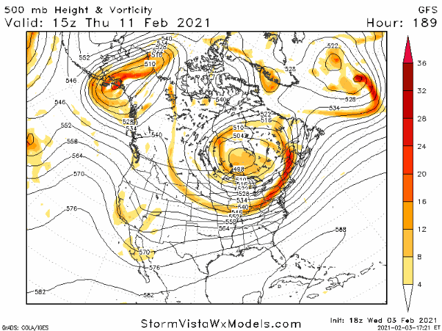
The GEFS has two storms. One that hits mostly N GA/N SC/NC/S VA with a second event further down into SC.
-
4 minutes ago, NorthHillsWx said:
Need to save this run for the archives. Agreed, might be the best I’ve ever seen
The only thing I’ve seen look nearly as good is some of the runs we saw before December 2018
-
2 minutes ago, griteater said:
Before I saw this clown map I was about to post that's one of the best modeled storms I've ever seen
I’ll gladly take a quarter of that run and call it a winter. You and I have been at this a long time and that might be an all time run.
-
 9
9
-
 4
4
-
-
-
5 minutes ago, griteater said:
GFS looks dam near beautiful next Sat on the happy hour GFS lol
Cant draw it up better.
-
1
-
-
Control run has a...snowstorm for the entirety of the Carolinas. All of us, down to the GA/SC line by Savannah.
-
2
-
-
Doesnt look like much ensemble support for snow as far south as the 12z GFS had it.
-
There's at least four different threats on the GEFS.
-
Incoming on the para at 210.
-
15 minutes ago, burrel2 said:
Don’t sleep on the Sunday morning threat. Thermals look good for snow on the gfs/nam for my backyard if the precip shield ticks north
Yeah, it's basically just the very bottom layer above freezing.
-
Probably a wet snow sounding for 2/7:
Forecast Sounding Data for 36.02,-78.97 GFS_US 96 hour valid 12Z 07 Feb 2021 Station: 36.02,-78.97 Latitude: 36.02 Longitude: -78.97 Elevation: 128.93 Press Height Temp Dewpt Dir Spd M 1000.0 129 -9999.0 -9999.0 -9999 -9999 SFC 999.5 129 2.6 2.0 331 2 S 950.0 542 0.3 0.1 306 5 S 900.0 974 -0.9 -1.6 276 8 M 850.0 1432 -0.5 -2.9 253 18 S 800.0 1916 -1.6 -2.4 249 28 S 750.0 2428 -4.0 -4.4 243 32 M 700.0 2969 -6.6 -7.7 238 39 S 650.0 3545 -9.7 -10.6 237 49 S 600.0 4159 -12.9 -13.9 238 63 S 550.0 4817 -17.0 -21.5 232 77 M 500.0 5527 -21.0 -31.3 226 89 S 450.0 6296 -26.8 -37.4 224 97 M 400.0 7135 -31.7 -48.8 224 105 S 350.0 8071 -35.4 -57.9 225 110 M 300.0 9132 -40.8 -61.4 229 112 M 250.0 10349 -49.0 -64.0 232 113 M 200.0 11792 -54.5 -67.3 239 113 M 150.0 13616 -58.8 -76.8 245 104 M 100.0 16124 -63.7 -82.8 252 89 -
It's snowing at IGX by 7AM next Friday. It then proceeds to snow off and on until the following Tuesday.
-
The GFS is so close on Sunday.
-
1
-
-
What is the first rule of a major pattern change showing up on the models?
it’s almost always too quick. We’ve got a lot of people who didn’t learn the fundamentals.
-
3
-
 1
1
-
-
2 hours ago, BornAgain13 said:
Looks like the Euro folded last night unfortunately
There's snow in the carolinas on day 7.
-
24 minutes ago, StantonParkHoya said:
I’ll be a cynic/realist for a moment — feel free to disagree or call me an ass — we have about 15 days in central/eastern NC.
1) We’ve been in an -NAO regime for 45+ days, that won’t last forever; 2) Late Feb is the new mid-March in the 21st century climate; and 3) Sun Angle(.)
Spring cometh despite the weenie protest.
I don’t think you’re wrong. It gets tough after Valentine’s Day outside of some anomalously cold events.
-
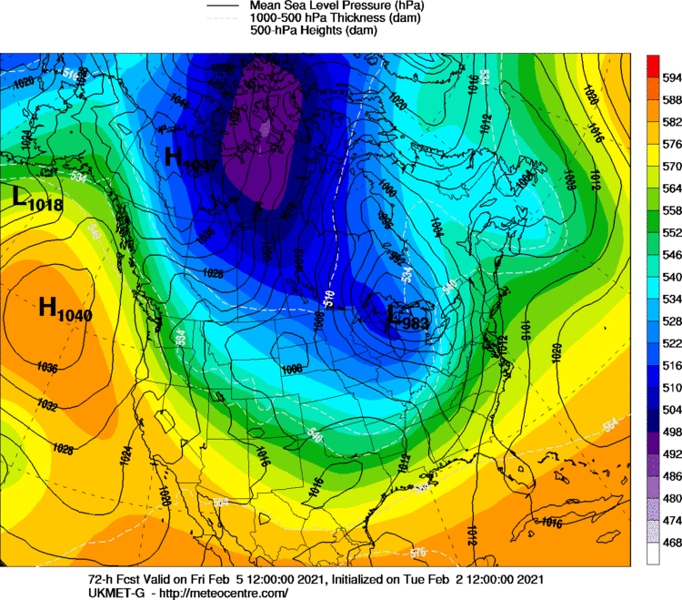
Euro control at 18z:

-
2
-
-
7 minutes ago, griteater said:
It looks like it's just a matter of the amplitude, location, and orientation of the ridge that goes up into Alaska. The UKMet has -32 deg F in Iowa at the end of its run at hr144
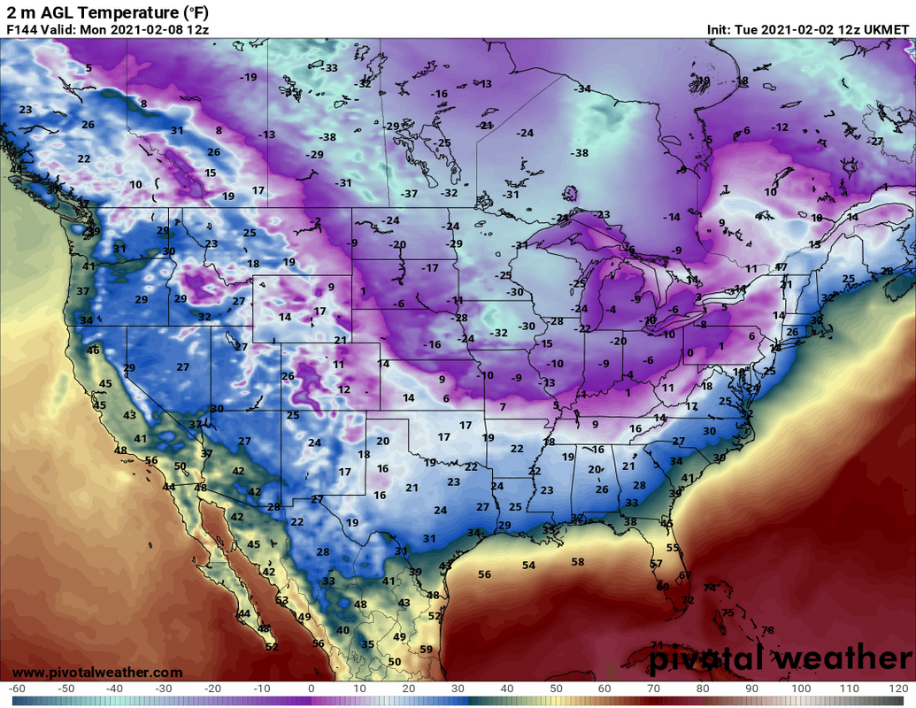
And that for a model with a known warm bias.
-
GEM Ensembles seem to like Sunday quite a bit

-
1
-
-
Hey, it's snowing on the south side of CLT
-
I think north of I-40/I-85 is still very much in the game for this weekend.
-
2
-
-
Just now, StantonParkHoya said:
???

I got nothing.
-
2
-
 1
1
-
-
12 minutes ago, BullCityWx said:
26/49 EPS members at Chapel Hill have measurable snow on Sunday. 29/49 at Roxboro.
An increase of 5 at TDF and 2 at IGX from 0z.
-
26/49 EPS members at Chapel Hill have measurable snow on Sunday. 29/49 at Roxboro.


Mid to Long Term Discussion 2021
in Southeastern States
Posted
Don’t forget about that euro control run