
Radtechwxman
-
Posts
2,099 -
Joined
-
Last visited
Content Type
Profiles
Blogs
Forums
American Weather
Media Demo
Store
Gallery
Posts posted by Radtechwxman
-
-
I would love if tonight overperformed like hrrr is showing here. Esp since it screws me mostly on back end precip
-
46 minutes ago, SchaumburgStormer said:
Of course a massive bubble of lower totals right where I'm at
")
-
 1
1
-
-
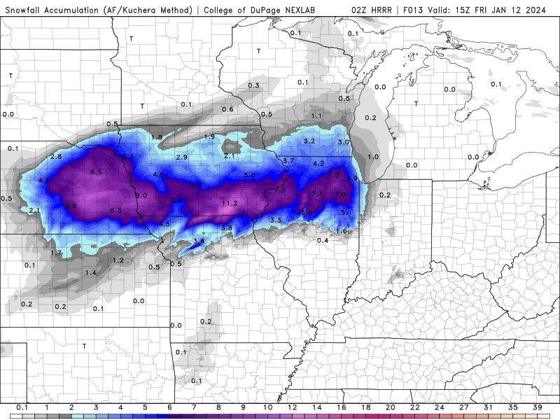
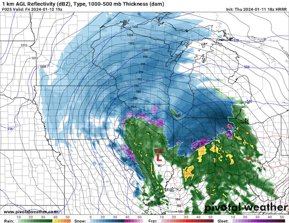
0z hrrr is very odd. Have a double barrel strengthening low. Both low centers strengthening. One tracks basically over me and the other well se. It changes over precip from east to west. Gets me in a waa screw hole between lows. Not sure I buy that evolution. Very strange.
-
Euro is skimpy with back end deformation snow compared to other models esp further south on tail end. Another thing I noticed is that hrrr last few runs has shown the waa precip staying snow here longer before mixing.
-
5 minutes ago, Chicago Storm said:
Ya'll are slacking... No 18z GGEM mention?
When was the last time that model was right?
-
Okay real question. It's been pondering me a while. How does this system have so much more warmer air with it vs the last? I get trough geometry is a bit different but I still am baffled with the track similarities between this one and last and how this time it looks mostly liquid here. Stronger llj? Deeper cross section of waa vs last?
-
1 minute ago, SchaumburgStormer said:
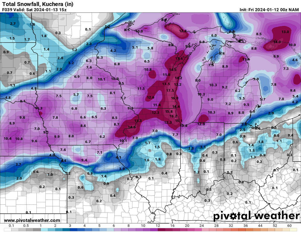
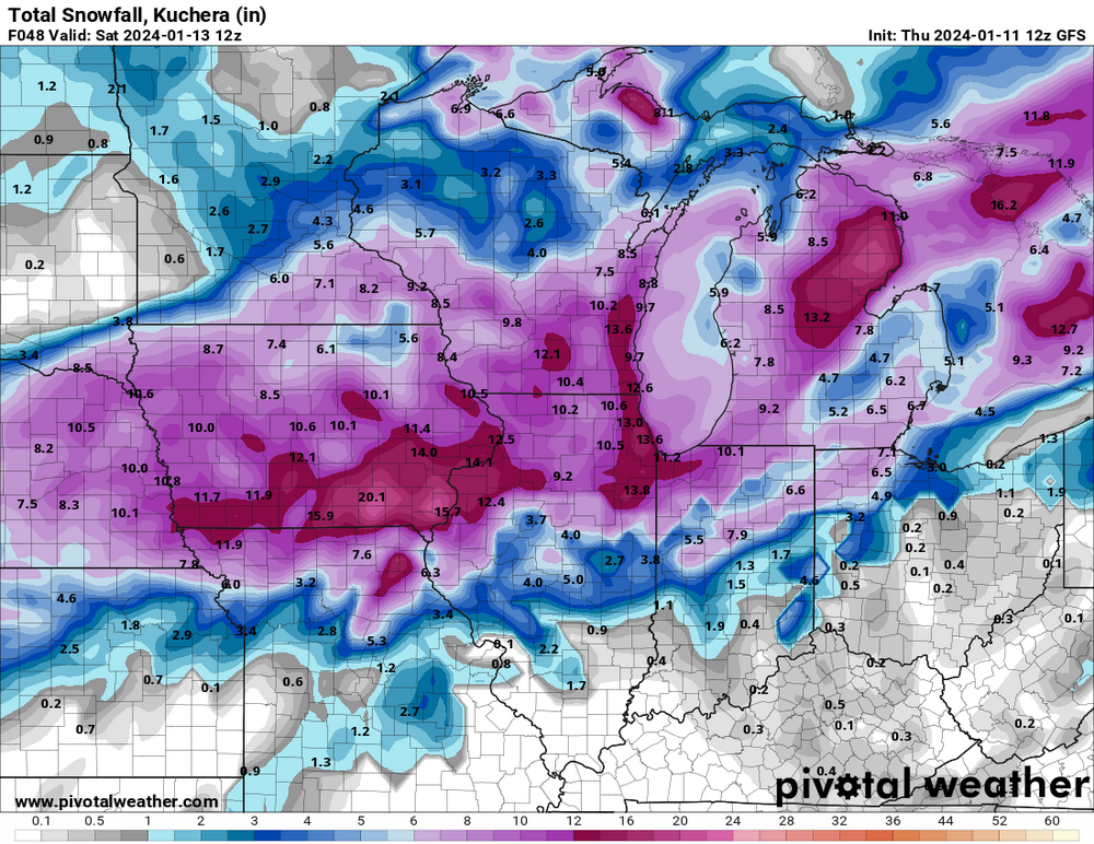
Would be wild if it played out as progged on the GFS. Downtown and the riverfront get 2-3” while the north side of the metro has 8-12”
Gradients and cutoffs are going to be wild with this. I look to be very close to one. My forecast is 0-6in based on latest model runs.
-
43 minutes ago, SchaumburgStormer said:
FWIW, GFS seems a touch south and east
I actually felt like it came nw. Has kind of a barrel double low then one takes over further east. Nam/rap/hrrr were hinting at this at times. Maybe they were right. The snow gradient across Peoria County is comical.
-
5 minutes ago, andyhb said:
Seems to me that some of this recent uptick in snowfall totals for those within the cold conveyor belt is an increase in coverage of the backside/deformation precipitation. One has to wonder if the general lack of convection further south may play a role in this. Ratios will no doubt be higher in this zone as temps crash behind the low.
That is a good point. Noticed spc has toned down severe threat due to poor thermodynamics and limited moisture return. So less convection.
-
I wouldn't trust nam. It did terrible with last storm.
-
Nam continues to be so nw with the low track
-
7 minutes ago, mnchaserguy said:
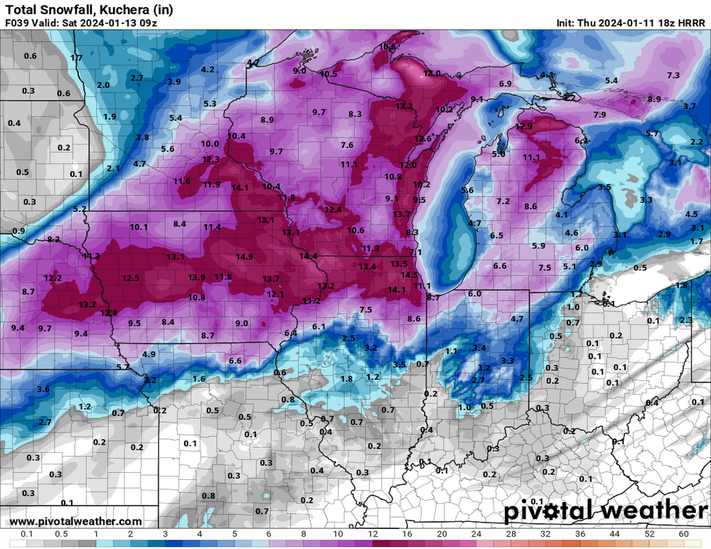
I wish we could just agree to take what the hrrr shows right now. Chicago gets its storm, Minneapolis gets a nice dumping, Michigan gets a nice storm, and a lot of snow in between. This is about a best case scenario run for this sub.
.Not really. Lol. Screws the parts of IL that also missed out on last storm. And Ohio Valley really getting the shaft.
-
 1
1
-
-
14 minutes ago, SchaumburgStormer said:
I’ll have what she’s having…
That stings a little. Just love barely missing a massive snowstorm and possible blizzard
17 minutes ago, Chicago WX said:
Hoping hrrr is overdone with that warm surge. Or changes over sooner
-
Lol instead of getting better consensus it's getting worse
-
1
-
-
1 minute ago, Weather Mike said:
GFS has been very consistent. Good to see that trend ....if it unfolds that way
Minus the void over my county
decided to keep rain here longer
-
Comical that gfs hammers areas all over me and has a void over Peoria County where I am #weatherdome
-
13 minutes ago, SchaumburgStormer said:
Most of the short range models were too far NW with the last storm at this range, fwiw
This. Not trusting them 100%. Globals actually did better with track on last storm.
-
Nam/rap/hrrr still seem to be on nw side of other guidance. Will make huge difference here.
-
At this point I would start trusting hi res guidance more over globals. 06z hrrr seemed to be finally in line with other models. Rap was still pretty nw.
-
06z euro a little drier. Wonder if it will be like last system where after it occludes deformation zone starts to lose steam.
-
Euro still not wanting to play nice for areas further south like other globals. Crush job for Chicago and N IL of course. Man this one hurts. That track on euro looks so good for here normally. Hoping maybe that warm nose won't get that west.
-
44 minutes ago, Natester said:
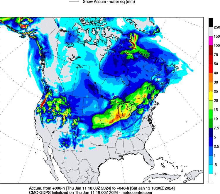
03z RAP takes the low to Chicago/Milwaukee and bombs it out to 965 mb.
Feel like rap/hrrr will continue to nudge se closer to guidance like last event
-
Gfs is remarkably consistent compared to the other models
-
1
-
-
Team gfs and rgem till the end. Ride or die


Jan 11-13th Blizzard
in Lakes/Ohio Valley
Posted
Yeah we just can't catch a break meanwhile the rich keep getting richer from the last storm. Must be nice. Lol