

nwohweather
-
Posts
3,548 -
Joined
-
Last visited
Content Type
Profiles
Blogs
Forums
American Weather
Media Demo
Store
Gallery
Posts posted by nwohweather
-
-
Toledo was 2 degrees at midnight. With lower temperatures in the afternoon, I believe this will break the record low max of 8 degrees. The daily record low is -5 for Toledo, so that should easily be broken by morning. This -5 record low quite a bit different from the all time record low of -20.
The dew point is going to be around there so it’s certainly possible to get that record. I think Toledo finishes at -16 or -17 in the early morning hours tomorrow.
I cannot get over how windy it is, and yet these crazy numbers are achievable -
Literally had this same thought a little while ago. 80 degree dews back then to what's on the way. Almost like being on a different planet.
It’s why settling this country is such an impressive feat by the colonists. The American Midwest has to be one of the most versatile climates in the world, the fact in my city of Toledo alone you can get 22 90° days and an average of 40” of snow with temps getting as low as -15° is insanity-
 1
1
-
-
Jeez models showing a solid 3-6” for Toledo on Monday with a serious serious shot of cold behind it. -6° for a high on Wednesday is beyond absurd
-
Currently -7° in Toledo
-
My dad in Toledo says
"We have officially gotten 8.5 inches. We may have gotten a little bit more at the house"
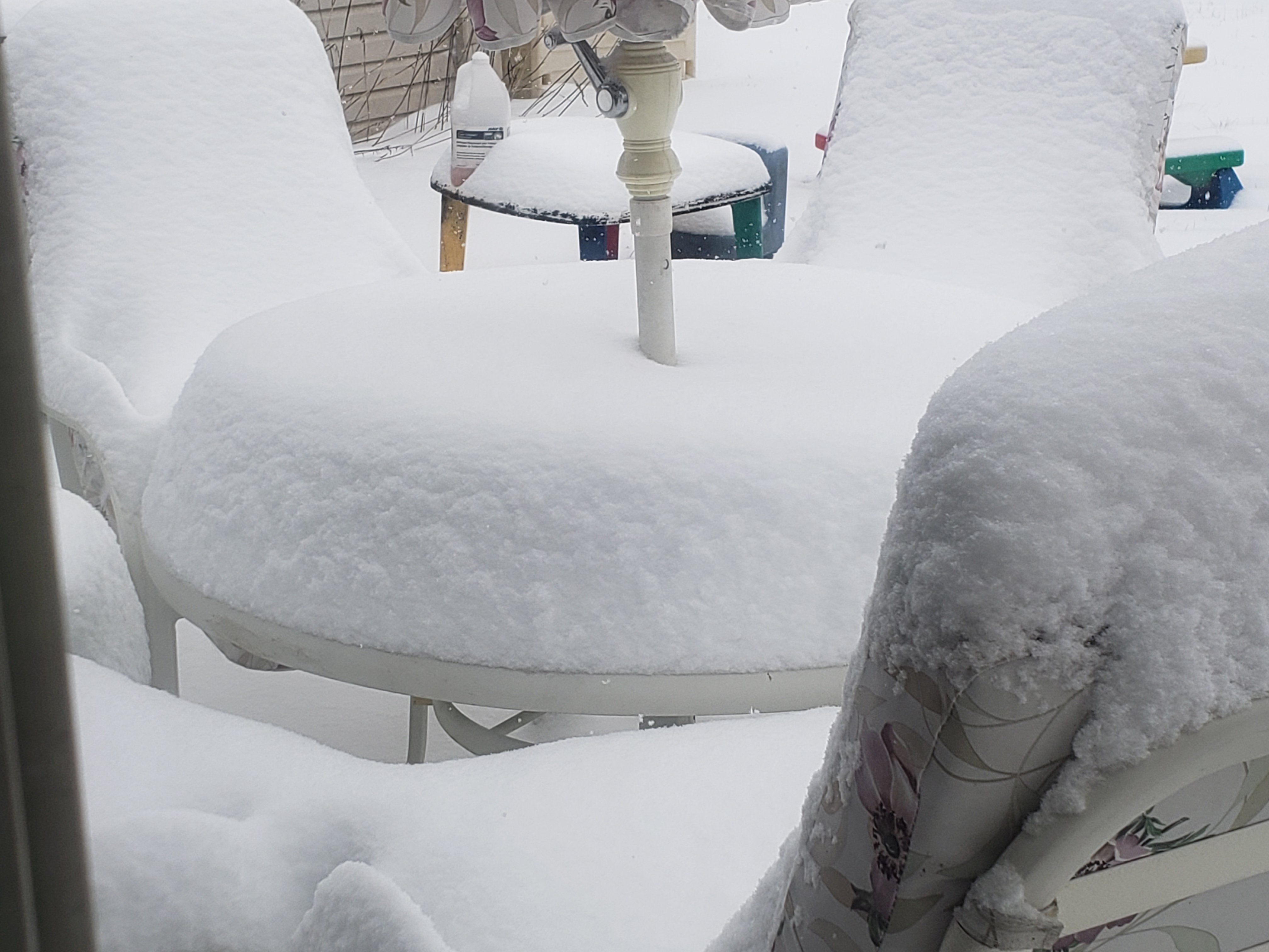
Going west-east the whole area got 8-12” with a foot out by Sandusky where they got additional lake effect. It was deep in the driveway, I’ll take a picture but the neighbors super duty F250 actually got stuck for a bit when plowing
-
1
-
-
My god the MOS has me at 6 right now!? Would flooding be a serious threat to the region with this system? I can’t imagine 2” of rain on top of all of this snow and ice
-
I’ll post pictures when the sun comes up but that was one of the more impressive snowstorms I have ever seen here east of Toledo. Easily the best since the April snowstorm of 2016 here as far as wind and snow intensity
-
1
-
-
21 minutes ago, Chinook said:
That sounds crazy! Note: only 30 kt (35mph) wind gusts at KTDZ (Walbridge area) have been measured. That in itself causes a lot of drifting.
Yeah I have a little kestrel and am a little south and east of that but she hit officially 49. Probably pretty close to accurate as I had to take a step back
-
I just hit 50 on my anemometer! Holy god this is as close to ‘78 as I have ever seen
-
2
-
-
You guys should see my pole barn. Up to 5 foot drifts on it currently and this band is ripping
-
4
-
-
All counties east of 75 in NW Ohio now under a Level 3 meaning the roads are closed to everyone except essential personnel
-
2
-
-
2 hours ago, geddyweather said:
Hindsight of course is 20/20, but a few of the 12z/18z runs (12z GFS, 12z CMC, 18z 12kNAM are the ones that appear in my head from memory) from Thursday had the setup nailed down the fairly well in IN/OH/parts of SEMI. Of course then things went down the drain at 00z that night setting up 24 hours or so of flat out mayhem. It will be interesting when this is all said and done to look back more deeply and determine what the system itself did, how it affected models in the close ranges, and if there is anything models could do to get a better grip on occurrences like this.
My question is why did people believe it in the first place. These stronger storms almost always come north the day of because the WAA pushes back against the high pressure more than predicted
-
4 minutes ago, Stebo said:
I have some good wind protected spots thankfully but yeah it is a bit drifty out there.
You should see it here. I can’t imagine what the rates will be like when this thing really tilts. The wind is really something. I’ll take a video in a second
-
6 minutes ago, Stebo said:
If I have this already, then yes i think i end up with 7". Currently measured 4.5"

I can’t believe you can measure anything. The wind coming off Lake Erie here is so strong everything is going sideways. Down to 1/4 mile vis now. The power poles are even fading at the end of the drive
-
1
-
-
Of course the WAA made it surge north and west. It always does and that's why I thought NW Ohio was in such a good spot
-
1
-
-
5 hours ago, nwohweather said:
Going to be one sharp cut off when this thing tilts. Current numbers verbatim go with 4” for Toledo, 6” for Toledo Express and 8” for Findlay. Does appear as there is some convective feedback issues on the GFS as it wants to dump a foot from Columbus over to Youngstown with sharp gradients up to the northwest corner of the state.
Just really curious where the deformation sets up as so many times we have seen it go west and north of where it was forecasted. 30-40 mile miss could be a huge difference
As I said earlier this morning...
-
Going to be one sharp cut off when this thing tilts. Current numbers verbatim go with 4” for Toledo, 6” for Toledo Express and 8” for Findlay. Does appear as there is some convective feedback issues on the GFS as it wants to dump a foot from Columbus over to Youngstown with sharp gradients up to the northwest corner of the state.
Just really curious where the deformation sets up as so many times we have seen it go west and north of where it was forecasted. 30-40 mile miss could be a huge difference
-
13 minutes ago, Jim Martin said:
Cleveland going for six to nine inches in the Findlay area by Sunday morning.
I’d say that’s fair for the entire area. Pretty much wherever that band sets up gets 9-10” and some serious rippage. Regardless the open space of NW Ohio is going to lead to blizzard conditions
-
I’m going with around 8” for the Toledo metro area, 6-9” expected. The combination of fgen and the powdery nature of the snow is going to lead to higher totals than the 4-7” they’re calling for. We almost always see this in the Great Lakes, strong pressure gradient puts down better than expected numbers
-
1
-
-
1 hour ago, Chinook said:
As an official snow weenie for Toledo, I am posting this NAM 18z run to commemorate a great model run for Toledo and Cleveland

Whoa is that legit
-
Jeez the local CBS station in Toledo going with 3-6” for this one. That sounds crazy just going on moisture availability alone honestly. I mean while a legit blizzard with 10-15” would be awesome from an enjoyment standpoint, it’s hard to fathom predicting what amounts to a strong clipper out of this
-
3 minutes ago, Stebo said:
The worry I have with that though is that we need the cold air behind this system, if it doesn't phase then you end up with the euro tonight with a good system bad thermos, until that system phases.
Yeah the baroclinicity was really one of its main selling points on being a big dog
-
32 minutes ago, Chicago Storm said:
What? No model goes negative tilt until after it leaves the region, and the ECMWF is fairly E-W overall with the snowfall axis until OH on east.
Which is where it’s highest totals are projected in Ohio.
Also the last storm put its highest totals down much further south where moisture is more abundant than the I-80 corridor. Just hard to believe in a cutter dropping that much snow in this area when typically the big dog storms have an Indy to Cleveland type of tilt to it
-
 1
1
-
-
Just not buying these high amounts with such an E-W direction. The Euro seems most realistic with its negative tilt
January 24 - 31 Cold Blast
in Lakes/Ohio Valley
Posted
My god is that air unlike anything I’ve felt before. This kind of wind is unbelievable with the cold temps