

nwohweather
-
Posts
3,553 -
Joined
-
Last visited
Content Type
Profiles
Blogs
Forums
American Weather
Media Demo
Store
Gallery
Posts posted by nwohweather
-
-
5 hours ago, Snownado said:
SC or WV?
5 hours ago, michsnowfreak said:SC? Why the move?
Yes South Carolina and for work
-
 2
2
-
-
don't disagree with the sharp gradient on the NW edge;"LOWER CONFIDENCE IN FAR NORTH/NORTHWEST CWA WHERE LESS
FAVORABLE SYNOPTIC EVOLUTION COULD YIELD AFOREMENTIONED SHARPER
CUT-OFF IN PRECIP SHIELD.," as LOT alludes too. But fairly solid 3-5" totals thorugh a good chunk of the metro. Ratio's should help. Areas south and east may get the bonus qpf, but with lower ratios.
Just beautiful. To be fair I’m moving to Charleston in a month so I’m owed a solid snowstorm haha-
1
-
-
Wow heck of a shot of snow for Northern Ohio. I'll gladly take a snow day

-
It has been a long, mild winter. Basically winter conditions from Mid November until now, not the snowiest year but it is seeming to drag on quite a bit this year
-
Got blasted with snow here. Probably closing in with 4”
-
1
-
-
1-3" for Toledo area on the advisory is joke. 3-5" would be the solid bet
-
 3
3
-
-
1 minute ago, RCNYILWX said:
17:1 is likely too high as an average but 10:1 is too low, probably near or slightly above climo average is the way to go. So let's say an average of 13 or 14 to 1.
Sent from my SM-G965U using Tapatalk
The DGZ seems so shallow with this system though I can't see it being too much higher than 10:1. 13:1 is probably correct
-
Just now, Baum said:
Nice head fake today. Can't say had concerns after the earlier 12Z GFS and NAM runs. Always get a chuckle at how these models can flip so quickly from one run to the next even as we close in on an event. In the past 36 hrs went from a non event to a moderate event with even greater potential to a nuisance snow. Just a bad year if your a snow lover...carry on....
The Euro never was showing it so you should consider basing forecasts among a blend of guidance and not just a couple. This by no means should be shocking
-
 3
3
-
1
-
-
Well personally a fan of this trend for Northern Ohio. But it should be expected, storms of this ilk seem to always go over Cincy and deliver a heck of a shot to Detroit, Toledo, Cleveland. We'll see how it transpires but 3-6" with mixing down towards Findlay seems accurate
-
1
-
1
-
-
Interested to see what the Euro does but I believe at the moment the GFS and NAM are trash. Too much dry air for a storm with ample gulf flow digging hard out of the Panhandle region being shown, I don't really buy it.
-
1
-
-
42 minutes ago, Snownado said:
2 months ? Met Spring begins in 26 days
Nah I consider it April 1st here in Northern Ohio. March is still usually quite chilly until towards the end of the month
-
1
-
-
What a remarkable day outside. Only really two months until Spring guys
-
Kind of a weird storm. Really strong low, but little precip on the cold side
-
 1
1
-
-
Yesterday the Toledo area was hit by a meso-low off Lake Erie
-
1
-
-
Looks interesting. Certainly a few storms upcoming
-
Just give me some cold so I can play hockey lol
-
1
-
-
Well well things definitely trended up for me in NW Ohio! I really like the consensus of 4-6" here in Toledo
-
1
-
-
5 hours ago, Snowstorms said:
2011-12, 2012-13 and 2015-16 were worse up until now.
2011-12 was a lovely winter in my opinion. It does stink when the snowmobile and ice skates stay in the garage but the weather was beautiful and sunny which was a nice reprieve considering what was on the horizon.
I think 2013-14 was honestly overwhelming, the constant snow and cold just wore you down. I do like snow, but 86" was too much for me
-
2
-
-
51 minutes ago, IWXwx said:
The 06z GFS was showing something similar, but I don't have a clue.
EDIT: My bad, that's the 12z

I believe it is due to the abnormally dry air off to the east of the low. Typically the cold conveyor belt moistens as it flows under the warm conveyor belt when wrapping around a storm and dries off a bit turning into snow on the backend of a low. This is honestly a perfect CAD example as you can see how as this moves east it drops freezing rain/sleet all over the Apps
-
1 minute ago, CoalCityWxMan said:
 spring can’t come soon enough at this point
It isn't here yet? Honestly one of the more mild winters I've seen temperature wise. Would not be shocked at all to see this be a backloaded winter though, it has all the hallmarks of that happening
-
1
-
-
5 minutes ago, Chicago Storm said:
However, the preceding storm system is not strong and there is some ridging ahead of this storm system.
Yeah I guess there is that baby low sweeping through tomorrow. Regardless of accumulations, that is one heck of a shot of freezing rain/sleet that goes through Northern IL/IN/OH on the Euro Friday night-Saturday morning. That alone is enough to cause significant travel impacts
-
42 minutes ago, RCNYILWX said:
GFS definitely trended back south with surface low vs 00z and 06z runs. If the GEFS and rest of the guidance doesn't jump NW, would think that trend will continue.
Sent from my SM-G965U using Tapatalk
It wouldn't shock me if this does trend south, typically in a loaded pattern your rule of thumb is storms keep going south of previous ones. Not always correct, but typically your cold is entrenched enough to kind of guide the low.
If anything I don't like the dry air off to the east. It could eat into some snow totals a bit
-
1
-
-
15 minutes ago, Snowstorms said:
I mean qpf can always be over or under modeled. We won't know until within 24 hrs.
But if you look at the 250mb wind map you'd see some subtropical influence and the PWAT maps indicate a good amount of moisture. It's a decent Colorado Low.
Well I'm going less on models, and more on actuality here. It may be a Colorado Low with a solid gulf stream of moisture, but there are three streams at play as always which can make a big difference on different sectors of the storm
-
3 minutes ago, Snowstorms said:
The HP placement is different than the last storm. We had to much WAA thanks to the strong SE ridge. It's a bit more suppressed with this event.
As I said earlier it is kind of weird to have such a strong high immediately to the Northeast instead of back to the west. What I do wonder with two of the three conveyor belts being drier air do you guys think it will lead to a colder and drier storm than is currently being modeled? My thoughts are that QPF is going to drop or be less than what is expected because of this
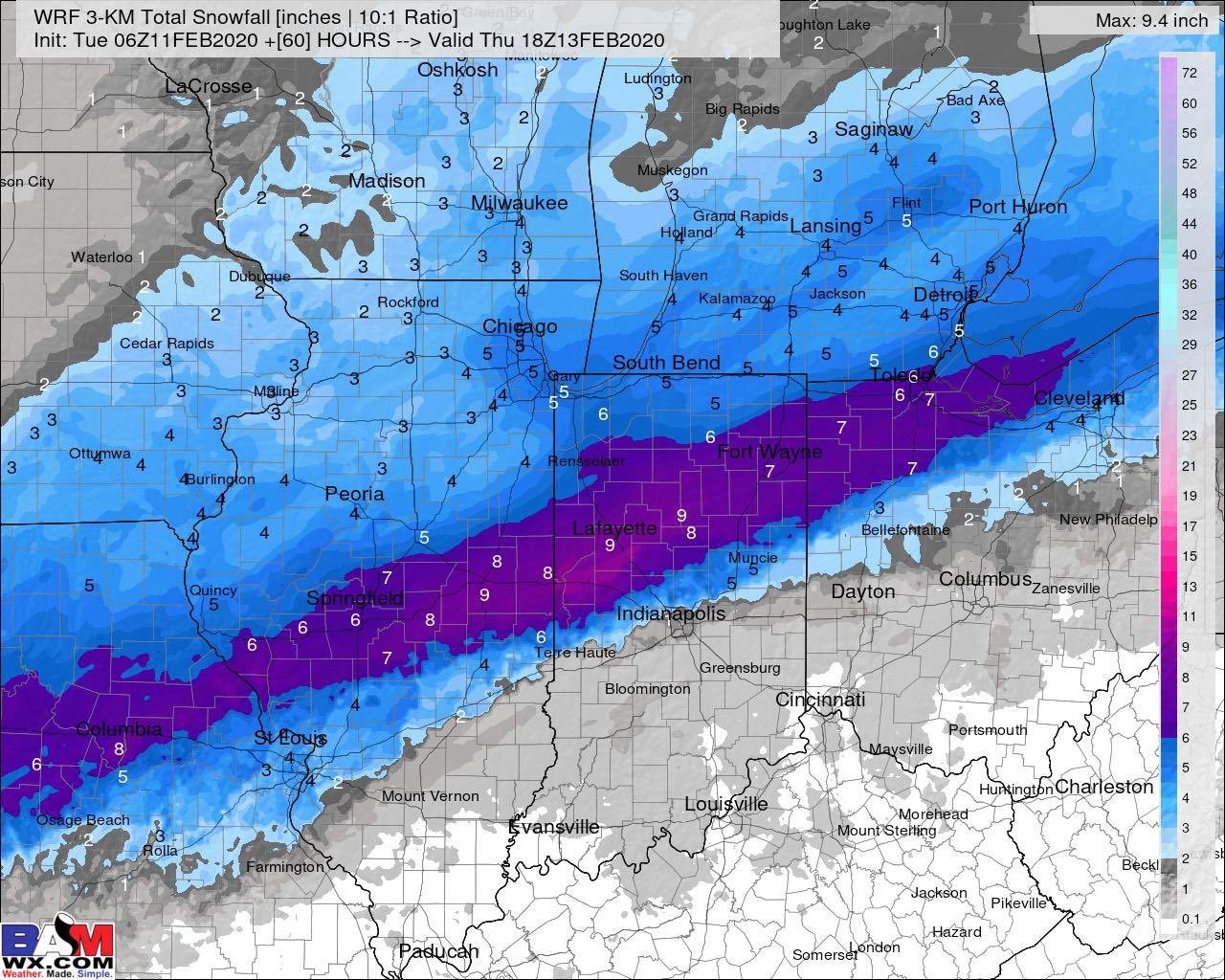
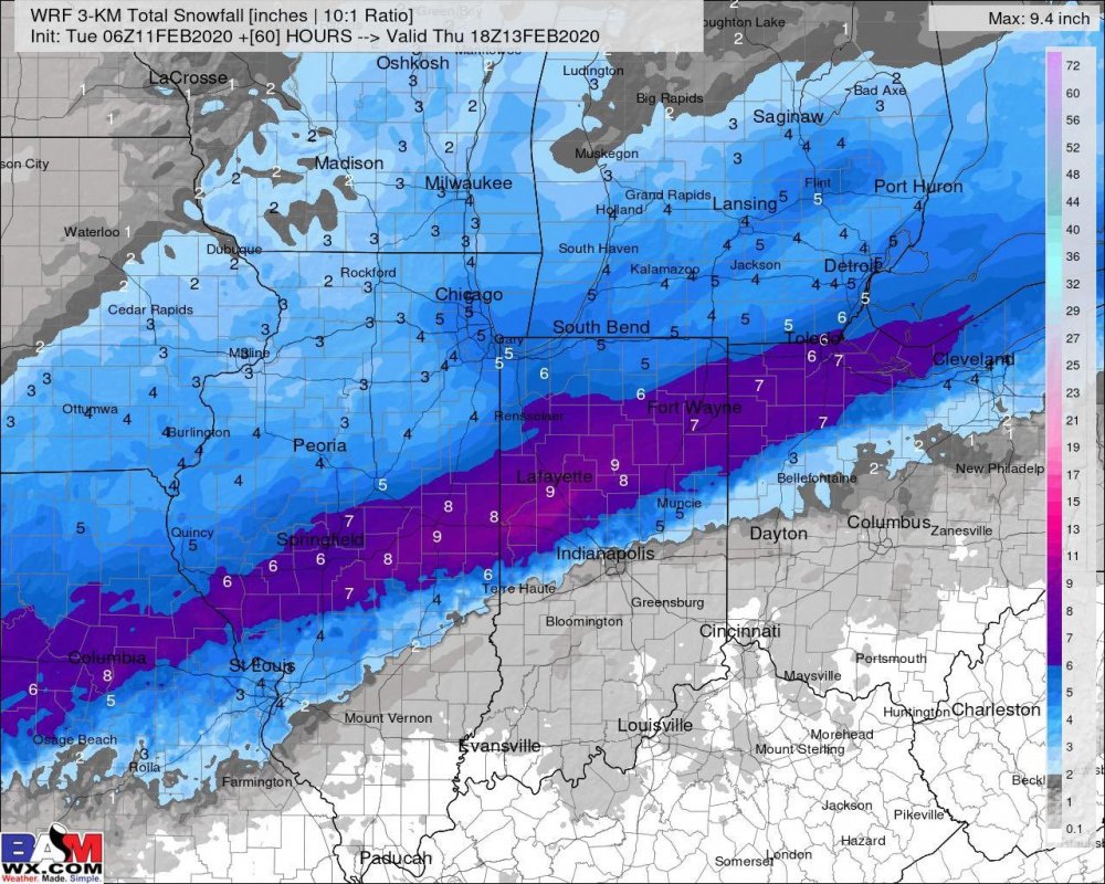
Feb 12-13 Snowstorm
in Lakes/Ohio Valley
Posted
Right? One of the best snowstorms of my life, for all intents and purposes it was a blizzard. Strong winds, 6-12" across NW Ohio and roads closed for 36 hours. Saturday snowstorm, and the roads were not drivable until Tuesday really