

nwohweather
-
Posts
3,545 -
Joined
-
Last visited
Content Type
Profiles
Blogs
Forums
American Weather
Media Demo
Store
Gallery
Posts posted by nwohweather
-
-
2 minutes ago, IWXwx said:
There is some broad rotation. IWX is getting reports of a possible tornado touchdown south of Angola in Stueben Co. EMA is reporting damage in that area.They are getting a survey team together.
EDIT: When I say they, I mean IWX
Both the CC and even base res show a rain wrapped tornado IMO
-
Hmm very odd with the rotation on that cell as well. Wouldn’t be shocked at all to see something rain wrapped, the correlation coefficient is up to something with it
-
Interestingly, May 9, 2000 was a severe weather outbreak for IN/OH/MI. There was a big squall line with a couple of tornadoes near Toledo. I remember it specifically. I was in Ann Arbor, watching The Weather Channel while hanging out with friends.
I remember the May 9th one. We huddled in the basement for that event, tornado touched down a few miles away with 70 mph winds and 1.25” hail -
It’ll be interesting where the outflow boundary gets laid down this morning. Might get some decent winds today as the disturbance moves east combining with a fairly unstable environment
-
Yeah it will be 60 or less from here on out. Maybe it will snow on Fourth of July as well.
Right lol? Seriously patterns always flip until they find balance, a below average stretch is typically followed by something above average, and next week looks terrific around here -
So far Toledo has received 2.5" of rain this month and 1.3" of snow. Haha what a January
-
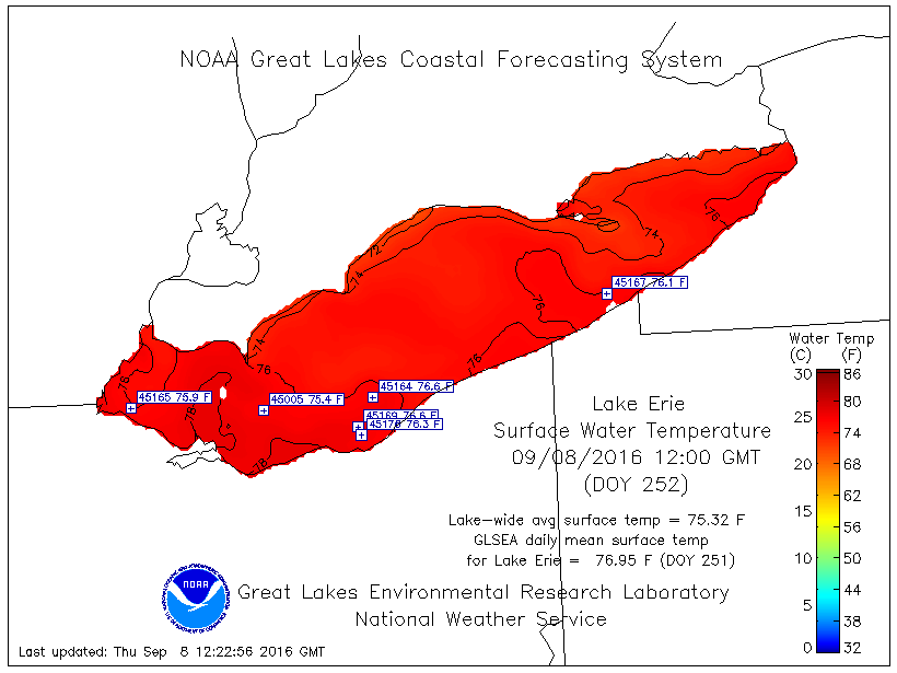
That lake temp in the western basin has dropped off pretty nice into the 40s now. Still can't believe it's close to 60 in the two deep spots of Lake Erie. Just a very long and mild growing season
-
What I'll remember about this Summer is not so much the heat but the humidity. Amazing to have such consistent high humidity with little rain. Yesterday was as humid as I've felt it around here... the rain earlier in the day was much needed.
Hopefully we can hold on to some of this warmth for LES season...
I disagree. While it was pretty humid in those later months, May-mid July was actually a terrific dry heat. Wasn't until late July that the major humidity kicked in -
Unreal the amount of severe weather up in Montana, Wyoming and the Dakotas for this season. Another enhanced risk on the docket for today
-
Impressive total.
Was the snow heavy enough to cause tree limbs to break or cause power outages?
Yes I had a big one fall at my house and about 10,000 were without power
-
Now at 5" of snow here in Bowling Green


Sent from my iPhone using Tapatalk
-
Currently getting snow flurries off Lake Erie. So so rare for NW Ohio to get LE but it looks like even an inch will fall over towards Port Clinton
Sent from my iPhone using Tapatalk
-
Lot of accidents out here in NW Ohio. The fog was so bad in town in BG I could only see one stoplight at a time
-
NWS 4-km precipitation analysis available here (for free) http://models.weatherbell.com/hrap/nws_precip.php shows that Toledo has had 9-11 inches of rain in 30 days (as of a couple of days ago) and Cleveland has had 9-13 inches. That's huge!
You should see it out here bud. To see almost every river except the Blanchard hitting a Major flood stage with top 10 all time crests in June is crazy to see. These fields with poor drainage have essentially turned into lakes with many farmers losing quite a bit of crop
Sent from my iPhone using Tapatalk
-
Yeah April was nuts as far as lack of rain but we have received quite a bit this week
Sent from my iPhone using Tapatalk
-
Officially hit 91 here south of Toledo
Sent from my iPhone using Tapatalk
-
Nothing quite like being sunburnt still and it being 40 out
Sent from my iPhone using Tapatalk
-
I like the 6-10" prediction with maybe a little leeway for higher totals. Either way double digit snowfalls in the wide open region of NW Ohio will equal the area being crippled for a few days
-
To add to that on my buddy's pond that we play hockey on we went from no ice two weeks ago to now almost a foot thick
-
Chinook my dad works right by there and his car was reading -10 so I do believe it
-
Hello. I'm resident in the Joplin area and I wanted to share a few thoughts I have. I am not a weather expert, and I have only been learning about weather in SWMO and the area the last few years. I started learning because as I was able to see weather broadcasts and warnings on TV, I really wanted to zoom in on the area closer to where I lived. Weathermen/women can't always do that when there are multiple storms affecting thousands of people across an area like we seem to have in the area. Therefore I started reading about weather on forums such as this. Thanks everyone for the information in this thread. Before that I bought GR2Analyst and picked up multiple radios to listen to spotters. I watched the SPC forecasts and tried to stay updated.
Joplin Tornado - I live on the north side of Joplin. I knew there was potential for major storms west of the area. My son wanted to play put-put golf that day. I told him sorry, we are staying close to home due to potentially bad weather. I watched storms approach from KS and OK. One cell looked like it had circulation and I think they did have sirens go off in Carl Junction or in the NW area of Joplin, This was the same time or right after the first sirens went off in Joplin. Then BOOM I was watching radar updates and I could not believe what I saw. Looking outside south towards the tornado all I could see what dark skies, lots of rain, and wind all around. I was a few miles north of the tornado.
I posted my experiences on another weather forum thread (let me know if I can mention it here)
Here are a few things I want to share and get thoughts on...
- Siren fatigue - I am not sure what to do about this. I have experienced this Spring, just a few weeks ago May 20th I believe, when the sirens go off now some towns have cops that drive around and use a different toned siren on their cars to warn everyone as well. I heard city tornado sirens are to warn people outside and are not meant for everyone to hear inside, I don't know if that is true. However now we have sirens and cop cars driving around with sirens on.
The May 20th incident there was a large area with a tornado warning. It looked to me like the circulation and tornado was down by Seneca and there was not anything close to Joplin. On the TV the weather woman said they are getting a lot of calls asking why the sirens keep going off. She said while the area is in a tornado warning, the sirens will turn on for period of time, then turn off. After 10 minutes they run on again and repeat. This will continue until the area is no longer in a tornado warning. Now I am not sure how many tornado warnings there are, but I can see why people have said they are turned on all the time.
- Small tornadoes - Another thing I have experienced myself is a wall of storms moving across the area. A thunderstorm warning is issued, sometimes with hail confirmation. These storms happen quite often. They don't look like anything unusual. Then a small EF0 or EF1 tornado spins off it and causes damage. Sometimes the sirens turn on after this occurs as the tornado is not spotted until damage has occurred. When you combine this with the item above, you have overly amount of warnings for potential large tornadoes and potentially no warnings for small tornadoes. Again I have no idea what to do except let our experts keep studying and try to learn how to predict better. I can see how people living outside major tornado areas would think it seems silly people that live in tornado valley and other high risk areas are not informed more. The truth is you just never know even today when a tornado is going to hit. The only thing we seem to know is if a potentially large tornado COULD hit.
- Hills & Trees - Growing up in the midwest plains north of here it was different. When we had storms we could look out across fields and see them coming. We could see funnel clouds, etc. There are many places in the Ozarks where it really is hard to see anything coming, except when it is right on you. There is a reason many storm chasers don't like to go over to Missouri/Arkansas, it's hard to see the tornadoes unless you are farther north. We rely on spotters to confirm tornadoes or rely on radar. I think sometimes "radar indicates..." warnings are also so numerous people don't take them seriously.
- Weather Outlooks - When people look in the newspaper, online, or on TV, the weather reports state thunderstorms possible, or strong thunderstorms possible. Is this enough information? Shouldn't the experts agree to some kind of scale and rating system? I realize then people will just say well the sirens are going off but the news said it was a low threat. However if SPC has your area in a high risk for tornadoes or some of the other rating systems out there, shouldn't we have some scale to report along side the thunderstorms? I knew the weekend of the Joplin tornado it was not a good day to be outside, but did a majority of people know this? I don't think the general public knew then or knows today the same potential risk that people in the weather community know and talk about. On weather forums we are surrounded by people looking at data and making predictions. Then there are people like me that read this and tell our friends. There are a lot of people outside these circles of communication that don't know the escalated risk.
- Local Folks - I don't know if it goes back to the mining days, when people from all over with different ethnic groups had to work together, rely on each other to make sure they were safe, that has rooted a fellowship with people in the area. Many people are very nice, and they help each other out. This was shown during the disaster. However I could see that when I moved here before then and it is one of the reason I like it in this area. The people are great.The surrounding communities and then farther away from all over, people were there to help. The local folks will never forget this. Thank you.
Finally I have to say, that storm warnings scare the crap out of me now. I used to watch in awe of the weather growing up. I was scared but also never felt I was not safe. Even with looking at our warning system and potential changes, the truth is if you are in a monster storm you could die. It was posted here that reports are a majority of the people that were deceased from the Joplin tornado were in their homes probably taking cover. Having that knowledge, experiencing damage in different tornadoes, and not knowing if a warning is going to be a tornado or if some high winds are going to spin one off and I will not get a warning, makes for an unsettling feeling. When I watch the radar during the Spring and I look at Oklahoma, I don't think I could take living there. I can barely see myself staying here. Even if it's one in 200 million chance.
As an aspiring emergency manager I like your comments. I'll admit I think meteorologists need to be more up front about tornadoes as well. Every warning says "strong rotation" when clearly it's obvious the difference between a baby couplet and a large mesocyclone in an atmosphere ripe for violent twisters.
I also know you're worry for all storm warnings. Right after a nearby community in 2010 was hit by an EF4 it was unreal how many calls and texts and tweets I would get about an approaching basic severe thunderstorm. One buddy of mine went to the basement! It's crazy how gunshy people are of the weather after a major tornado rips through. I mean just this year the skywarn meeting in that county had 250 people attend, that's insane for a very rural county
-
As far as setups go I'd say Alabama on April 27th was the worst I've ever seen. 80-100 LLJ, CAPE up to 3000 j/kg and Helicity levels of 500-600 may never be seen again in our lifetimes. Let alone we saw 10 monster tornadoes including one that ran through the most populated parts of Alabama and one that IMO was the worst of all time in Phil Campbell
-
I can easily say that the EF5s in this outbreak were certainly among the strongest ever from a damage perspective...
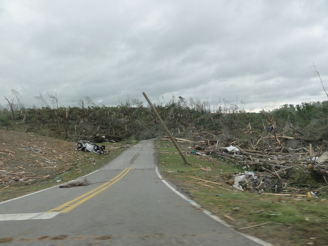
The damage in Phil Campbell was scary. This picture legit scared me the first time I saw it. The thing is despite all of our warnings what do you do when an EF-4 or 5 is barreling down on you? People were being sucked out of basements even
-
Yeah this one might be the real deal. The thing that worries me is that this year analogs 1974's spring the best and with all this actitvity it just seems like something extremely huge is eventually gonna blow up eventually
Probably the best prediction I've ever made right here, a week out. Hopefully we don't get into another one of these patterns but with May coming soon who knows. I'll admit I never thought we'd see another Super Outbreak again. It was just jaw dropping to watch this on the radar and tv. The tornadoes produced by this one were unreal in strength. To see the horizontal vortices on almost every twister, and the shear size and speed that they were all moving and spinning was just incredible
2018 Short to Medium Range Severe Thread
in Lakes/Ohio Valley
Posted