dta1984
-
Posts
1,775 -
Joined
-
Last visited
Content Type
Profiles
Blogs
Forums
American Weather
Media Demo
Store
Gallery
Everything posted by dta1984
-
Hoping this band can hang out before shifting north. Looks like tomorrow afternoon and overnight is our next shot, will be happy with the low end of that.
-
5.75" total so far. It's brutal out there!
-
Estimating 4-5" out there since yesterday. Not much on radar now, but hopefully we get some bands to form in the NW flow.
-
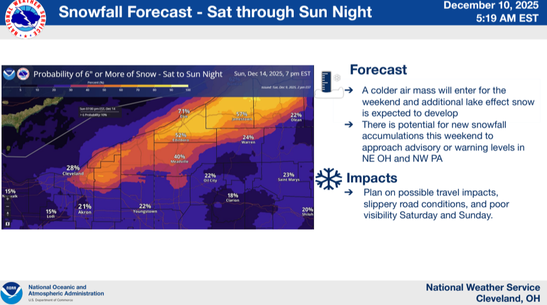
Just noticed this graphic from CLE for the weekend lake effect.

-
34 and rain snow mix so far this morning. Roads just slushy.
-
Looks like another shot (or several) at some snow mid week through this weekend. Hopefully any rain we get on Wednesday will be minimal before it gets cold again.
-
11.5" looks to be storm total here. HRR definitely did well. Impressive start to the season with 18" in November. Have to go back to 2014 for the last time I recorded more for November.
-
We just got home, snow stick on my deck is just below 9". I'll do a better measurement in the morning. The interstates are a mess as you would expect, but the worst stretch was definitely once we got on 422 from 480..
-
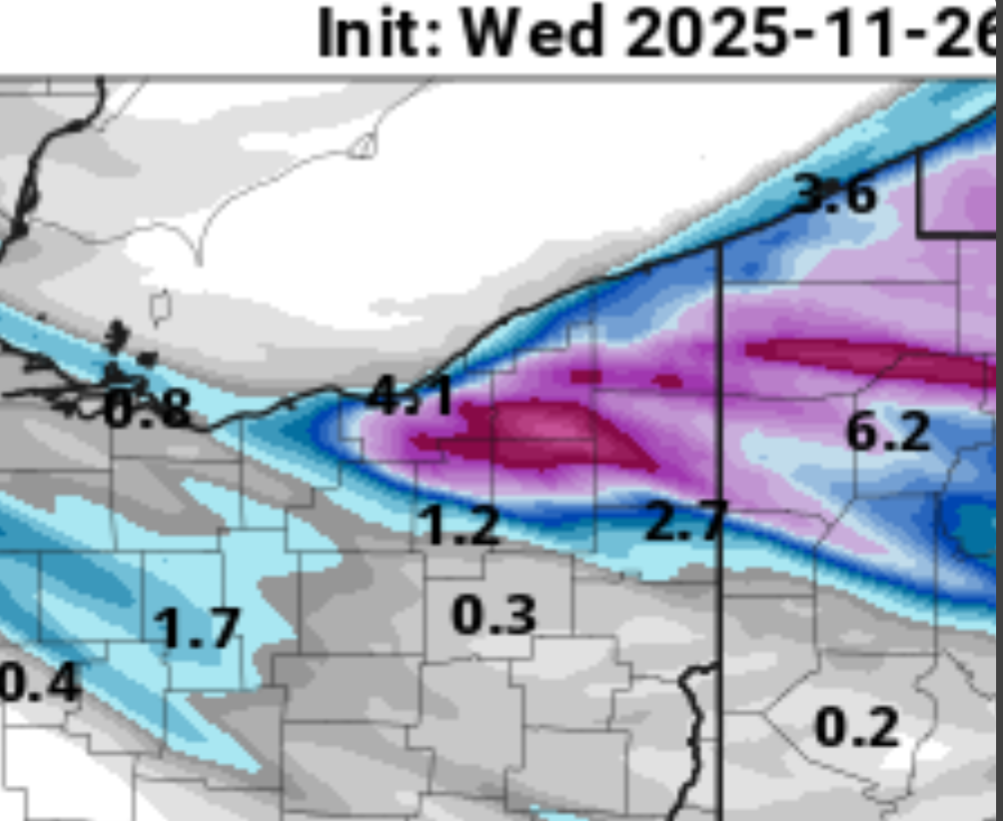
HRR runs have a near ideal band out this way.

-
Chances of some snow around Thanksgiving are looking pretty good. SW to WNW wind. From Cle morning discussion "By late Wednesday evening into the early overnight hours, the cold front will have departed to the east, leaving much of the region under the influence of a surface trough. With 850mb temperatures quickly dropping into the -8 to -10C range, this will mark the beginning of an increasing threat of lake effect snow. Initially Wednesday night, a sustained southwest flow across Lake Erie should isolate the heaviest band north over Lake Erie and have minimal impacts to the snowbelt minus possibly along the immediate lakeshore. By Thursday morning however, the upper level trough axis shifts east of the area and overall flow across the lake gains a more WNW wind component. This is expected to result in lake effect snow gradually shifting inland across the primary snowbelt. As this happens, ample moisture combined with deepening EQL and moderate lake induced instability should result in areas of heavy lake effect snow through Thursday night. Overall structure of the lake effect should be multi-bands with embedded heavier bands. Confidence continues to increase that there will be accumulating snow across portions of the snowbelt through Thanksgiving, but exact snowfall totals, locations, and timing remain uncertain. Given the increased travel surrounding the holiday, please keep up to date with the latest forecast and plan accordingly"
-
Great start to the season! My snow stick on my deck was at 7" total when I left for work this morning.
-
About an inch here overnight. Looks like the Huron band is getting organized now.
-
Flipped to snow here about an hour ago. Already a covering on the grass.
-
Lake effect rain season is here, definitely looking forward to next month when we can start tracking some snow. A lot of trees are already bare, we're not far away.
-
Looks like 83" imby last winter. Definitely was a good winter, especially after the past few terrible ones.
-
We definitely needed the rain, it's been a dry few weeks. Fall is definitely in full swing with leaves starting to drop. Temps have been pleasant and next week looks beautiful!
-
Incredibly wet month, I'm guessing we're getting pretty close to a foot by now? Parts of my property have only dried out for a short stretch in early June, otherwise it's been pretty damp.
-
Sure was! Looks like dry weather and 50s starting late this coming weekend. Not ideal, but I'll definitely take the dry streak.
-
Same, it's been a good (not great) winter and we were due after the past few clunkers. Bring on an early spring.
-
5" here since yesterday morning. Quite a long duration light snow. Definitely working our way towards a normal ish winter finally.
-
Just eyeballing this morning, looks to be 5-6" additional since my 3" measurement yesterday afternoon. Roads were still a mess this morning with the wind and light snow still falling. Overachiever
-
3" so far today. Currently not snowing, but looks like some lake enhancement picks up later this afternoon.
-
WSW now for 4-7" additional
-
Snow here now as well, big flakes. Pretty consistent agreement in the models of around 6" .
-
It's been a very scenic morning, right at 2" before it switched over to drizzle. Good start, hopefully tomorrow delivers as well.