dta1984
-
Posts
1,777 -
Joined
-
Last visited
Content Type
Profiles
Blogs
Forums
American Weather
Media Demo
Store
Gallery
Everything posted by dta1984
-
Quite the hail storm yesterday! That may be the largest hail I've seen since living out this way. It came in a few waves too. At first the hail was smaller quarter size, but the second round was more intense, maybe 1" diameter.
-
Ef-1 tornado confirmed about 6 miles from here. The storm with the tornado warning was brief, but very intense side ways rain and wind. Anyone know how much rain we received this past week? Has to be 2-3"? https://www.weather.gov/cle/weatherstory
-
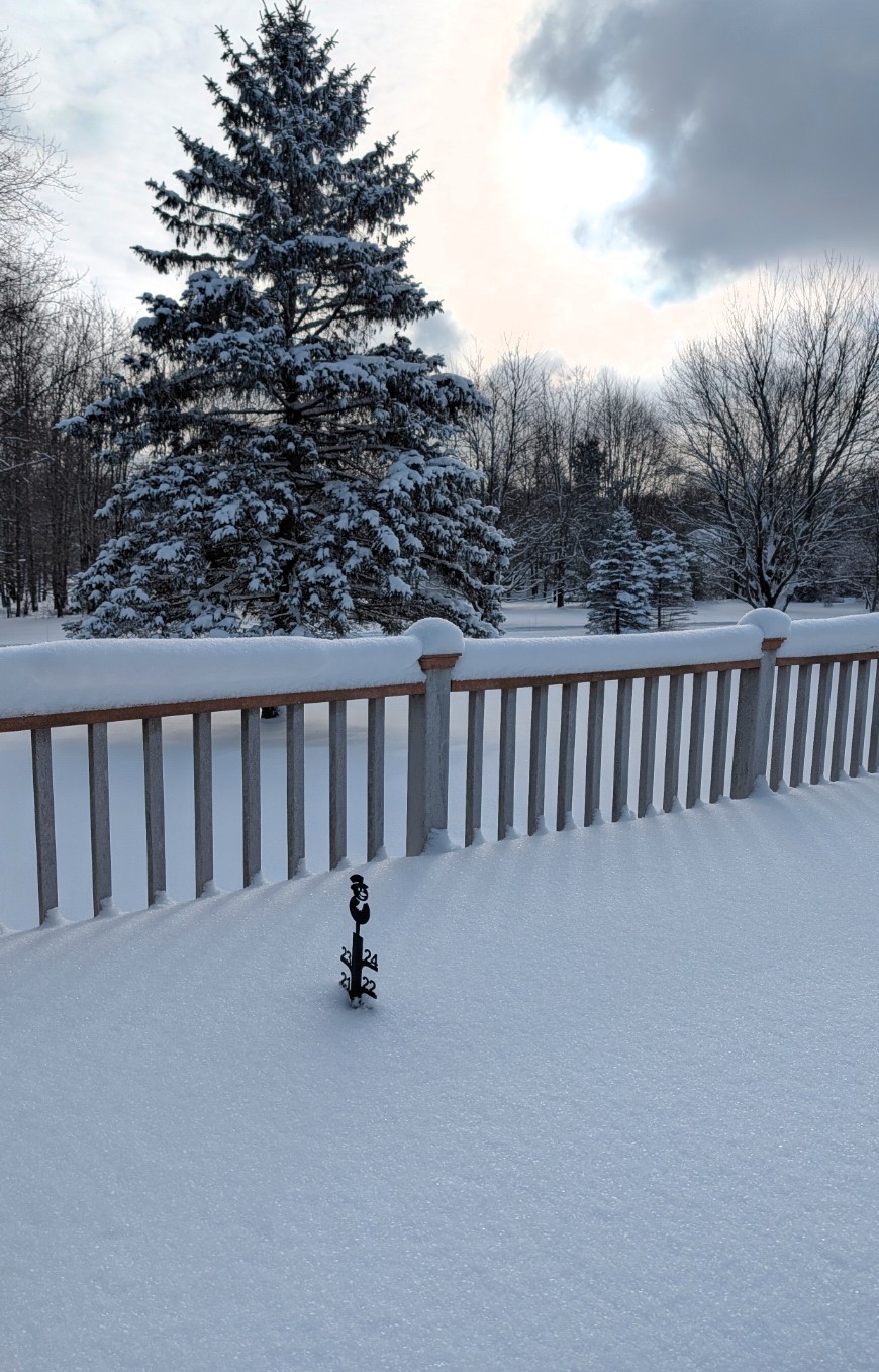
Back to winter today. Around 3" here on the deck. Jackpot was right around 87, there looked to be 4-6" in that area. I missed out on the meteor, but some pretty incredible videos of it out there!
-
My deck snow gauge is approaching 12". There's possibly some drifting near it, but still, I'm surprised we didn't get upgraded to a warning.
-
Winter is back. Estimating 4-5" so far, snowing moderately at the moment.
-
52 and beautiful outside, let the melting begin ! After tomorrow, doesn't look like many snow opportunities until the end of month...maybe.
-
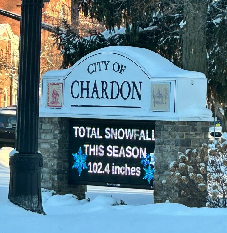
Saw the Chardon snowfall to date listed on the square digital sign. I'm not too far behind, about 10" less. It's been a good season so far.
-
With the overnight snow, I'm just below 21" after some compacting.

-
My storm total + the lake effect yesterday is 13". The lake effect was a nice surprise that helped boost the numbers. Back to snow again today, getting deep out there. I have 20" on my deck. Hoping to make a run at 24" as that would be the most since I've lived here.
-
Measured 6", but I'm sure more has fallen and compacted. Light snow currently, but radar still looks good to the west / south west .
-
I caught a reference to this in the cle discussion The past several model cycles have seen a NW shift in the track of the surface low and resultant axis of heaviest snowfall, and there is still time for further refinements to the track as model guidance resolves the aforementioned phasing. Northern and southern stream jet phasing is known to pull systems farther NW than models initially indicate, so this NW trend has not been surprising
-
Seems like consistency for a 10-12" range. Maybe more if the coastal transfer is delayed. Just hoping we don't waste too much qpf overcoming the dry air that's in place.
-
Ya it seems we have had this situation in the past, it's helped us a few times by hanging on longer and also gone the opposite way. Let's hope it hangs on longer before transferring!
-
That could be. I'm guessing the totals will creep up as we get closer to the storm. Curious to get @OHweather thoughts on the storm. I'm also wondering if model qpf output takes into account the dry air in place and qpf that will be wasted due to saturation?
-
Surprised to see a Warning already issued this morning. I like the snow forecast, conservative compared to some outputs. .WINTER STORM WARNING IN EFFECT FROM 7 PM SATURDAY TO 10 AM EST MONDAY... * WHAT...Heavy snow expected. Total snow accumulations between 7 and 10 inches. * WHERE...Portions of north central and northeast Ohio. * WHEN...From 7 PM Saturday to 10 AM EST Monday. * IMPACTS...Travel could be difficult. The hazardous conditions could impact the Monday morning commute. * ADDITIONAL DETAILS...Snow will spread into the region Saturday night and peak in intensity during the day Sunday. The snow will gradually taper off late Sunday night into Monday. Sub-zero wind chills are expected Saturday night into Sunday morning, and again Sunday night into Monday morning.
-
The weekend storm could be one of the most widespread we have had in a while. Some pretty large totals from icon, UK and Canadian runs. Will be interesting once we get into short range to see if the lake will add on anything additional.... though most likely frozen by then.
-
Ah bummer, figured it wouldn't take long with this cold stretch. Looks like a chance for a few inches tomorrow and tomorrow night. Maybe we can reel in this weekend storm that appears to be slowly bumping north?
-
Just had some thunder as the squall is approaching! The snow from a few days ago has compacted quite a bit, my 16" is at 10" now.
-
Congrats, you were due this year!
-
There's definitely some drifting, but I came up with 15" from several measurements. Still lightly snowing Pure powder, quite the storm!
-
Definitely an overachiever, between 10-11" on my deck and still snowing moderately. Going to be some big totals if we can hold on to some moisture through this afternoon.
-
Short rangers looking juicy, 8-12 through Fri roughly here and north, some are a little more north and just miss here with the heavier stuff. 6"+ looking likely. Wouldn't be surprised to get upgraded to a warning.
-
I'd say the southern half of the primary snowbelt has done well this year, secondary too as you mentioned
-
4" here so far and the radar keeps filling in over the lake, nice surprise. I think the RGEM was the only model to show anything more than a few inches.
-
Measured an additional 5" mainly yesterday evening and overnight. Storm total would be 12.5", which seems to align with other nearby areas. Pretty good storm overall! This puts me at 50" season to date.