-
Posts
2,218 -
Joined
-
Last visited
Content Type
Profiles
Blogs
Forums
American Weather
Media Demo
Store
Gallery
Posts posted by Cyclone-68
-
-
I guess hearing a couple of early rumbles this morning wasn’t a positive harbinger for the rest of the day after all
-
3 minutes ago, CoastalWx said:
Wagons south
Repeat of last summer? Seems like everything missed south by 10 miles
-
I was a bit surprised the point and click had this all out of here by 3pm? I thought this would go into the mid evening based on what I read yesterday?
-
Maybe some booms up in the northland today?
-
Typical eastern MA spring day in progress (unfortunately)
-
Some areas looking at possible severe later this week?
-
 1
1
-
-
-
 1
1
-
-
Speaking of OK things are starting to pop now
-
25 minutes ago, weatherwiz said:
I wonder if we'll ever see a high risk any further east than what we saw 5/31/98. The only way it ever happens if there was a legit signal for a derecho to rip across NY/PA and SNE (or NY across NNE). We would never see a high risk for tornado probs, one reason being the spatial size of our geography is just too small. I wonder what the outlook was for 7/15/95.
Would 1953 have warranted a high risk?
-
To be fair, even today isn’t the total disaster I thought it would be. Albeit a bit chilly
-
 1
1
-
-
Central NE stealing our sunshine and storms..Our snow wasn’t enough

-
I probably mentioned it here before but I have bad seasonal affective disorder and hopefully when I retire in a few years I can head south for at least a warmer (sunnier?) climate
-
 4
4
-
-
-
Cicadas, an earthquake, and an eclipse. Glad I’m not superstitious
-
I felt one on the 10th floor of the MGM Grand in Vegas about 25 years ago. THAT was wild
-
 1
1
-
-
Is the mid Atlantic stealing our snow AND earthquakes? Seriously though didn’t feel anything here
-
 1
1
-
-
1 hour ago, weatherwiz said:
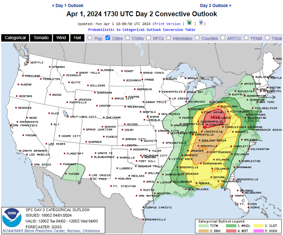
The increase in severe weather potential and quite a bit northward shift in severe weather potential for tomorrow is wrecking some havoc. This could be a sign for a stronger primary into western Michigan at least as that would favor the warm front lifting this far north to warrant these severe probs. It will be fun later today, tonight, and tomorrow to watch in real time how the convection is influencing the upper levels
Centered over Ohio just a day before the 50th anniversary of the Xenia storm
-
28 minutes ago, HoarfrostHubb said:
I hate this event in every way possible
This winter has been the equivalent of putting sharp toothpicks under fingernails
-
 1
1
-
-
1 hour ago, CoastalWx said:
I have been savagely beaten last two years.
1 hour ago, CoastalWx said:I have been savagely beaten last two years.
Here here
-
Is Reed Timmer a hypemaster? He’s predicting a big tornado outbreak in OK/AR/KS on Monday next week. He even drew comparisons to 2011
-
-
21 minutes ago, CoastalWx said:
Nice WF convergence in srn areas. Maybe some thunder too. Deep winter continues.
Thunder would make this the winter highlight for me
-
 1
1
-
-
Is this officially the longest stretch without 4+ inches in a storm for Boston?
-
 1
1
-
-
Screw it. Can’t get any snow so let’s at least set some records
-
 1
1
-


May 2024 Discussion - Welcome to Severe Season!!!!
in New England
Posted
Some big man booms just now