RodneyS
-
Posts
1,429 -
Joined
-
Last visited
Content Type
Profiles
Blogs
Forums
American Weather
Media Demo
Store
Gallery
Everything posted by RodneyS
-
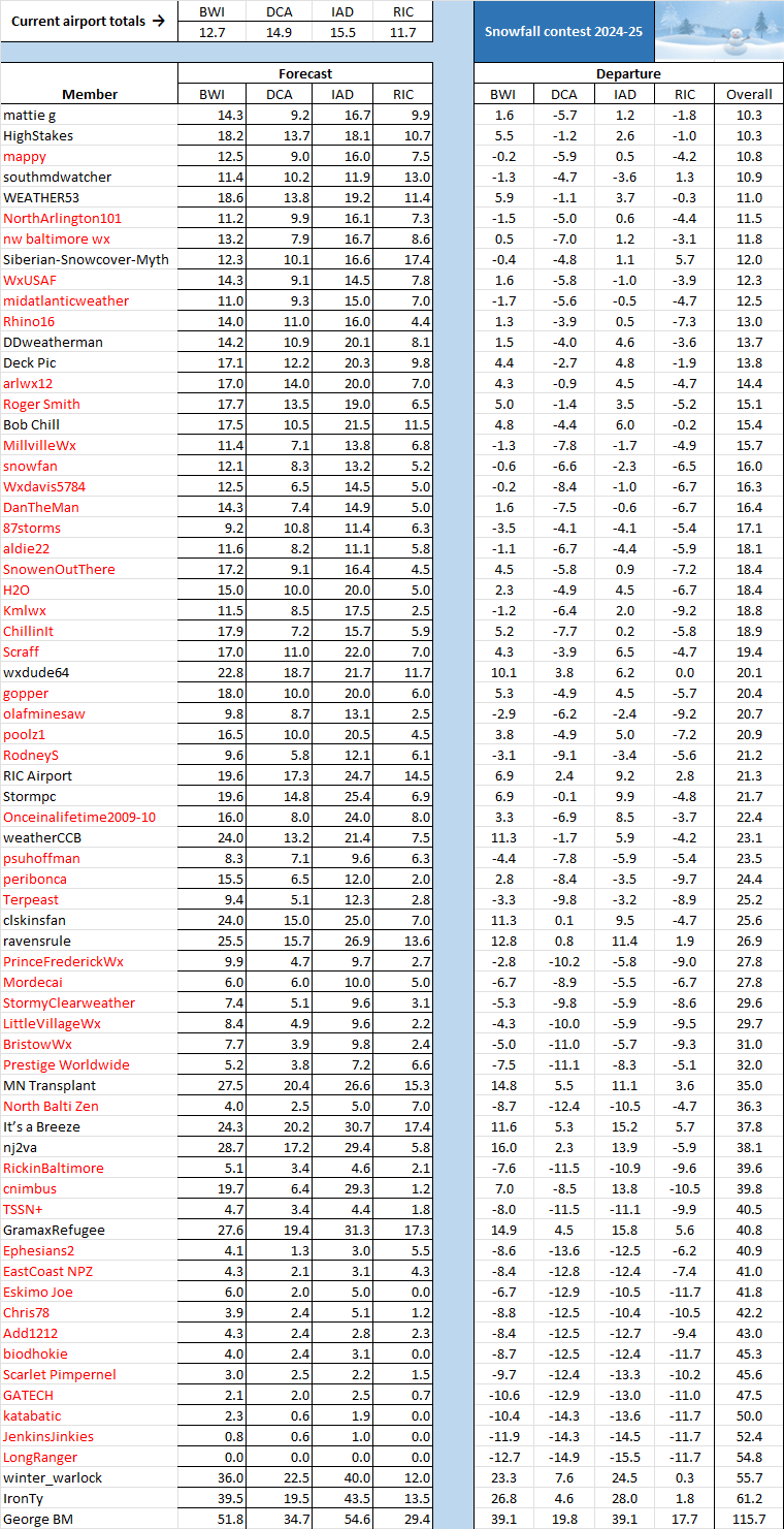
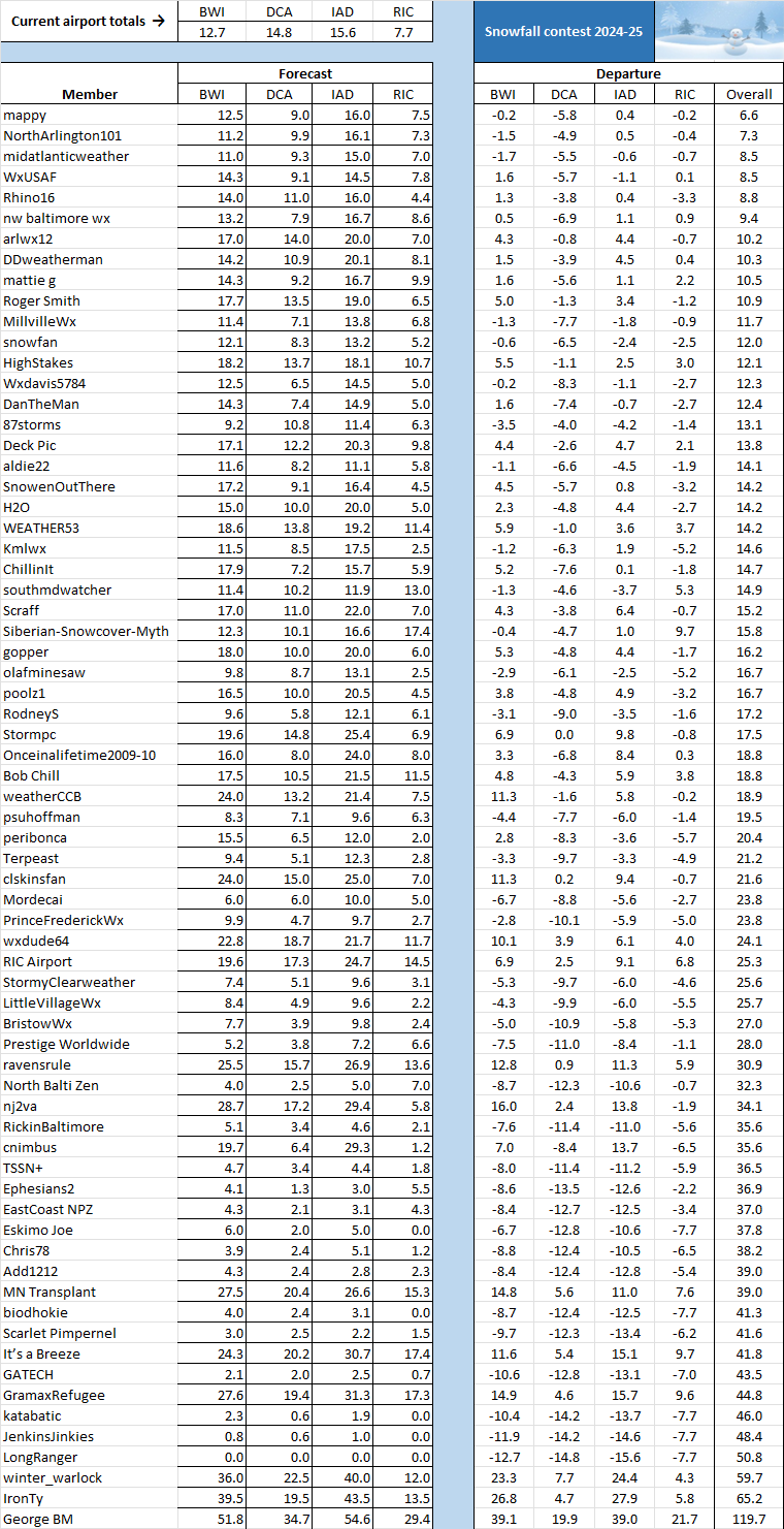
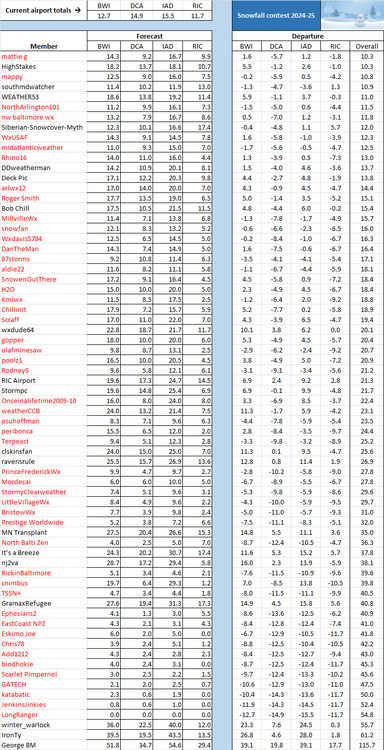
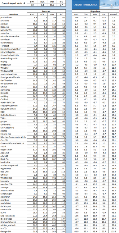
FYI, each of the four airports recorded only a trace of snow today. However, I am updating the table to show that -- barring corrections to the snow totals -- two more contestants have been eliminated from contention, to bring that total to 50 (in red), leaving only 19 who still have a chance to win. Most stunningly, I have determined that co-leader @mattie g has bitten the dust. Why is that? Because while he could still finish in a first-place tie with @HighStakes, he would lose the tiebreaker based on his forecast of 8.6 inches of snow at Salisbury (SBY) vs High Stake's forecast of 10.8 inches there. Because SBY has already recorded 17.8 inches this season, mattie g is history -- just as the other 49 of us are.
-
Thanks - - see updated table below, which also includes another 0.1 at DCA:

-
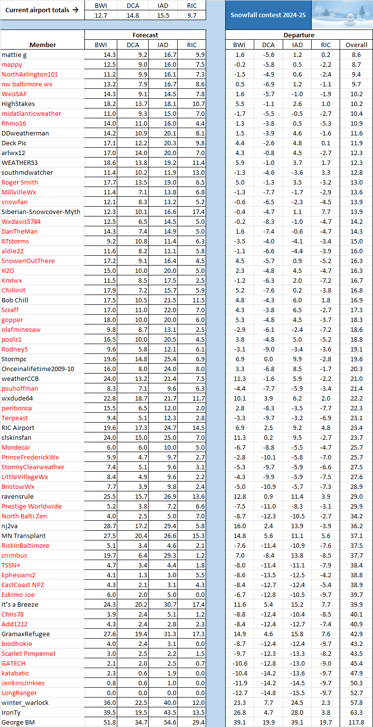
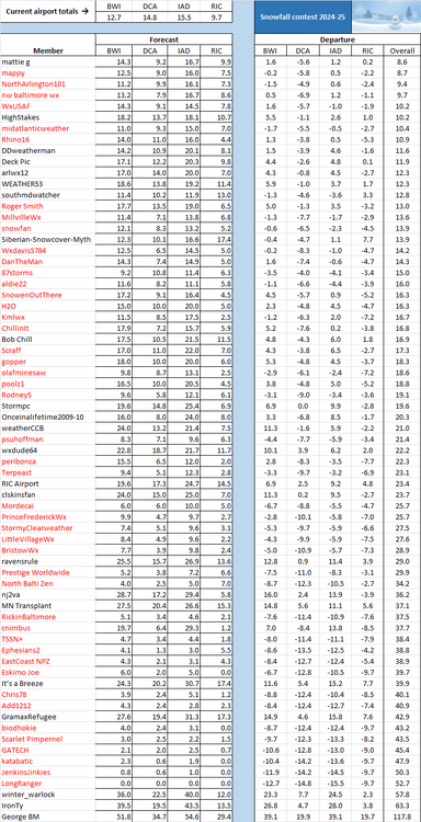
We have a new leader, as RIC has already recorded 2.0 inches today. That puts @mattie gin first place, with @HighStakesa big threat to move into a tie before day's end and @southmdwatcherlurking if RIC records several more inches.
-
Yes, and this season may make it 15 times. By the way, the largest amount by which DCA snow exceeded BWI snow was 5.5 inches in 1979-80 -- 20.1 inches at DCA, 14.6 at BWI. On the other hand, the largest amount by which BWI snow exceeded DCA snow was 20.9 inches in 2009-10 -- 77.0 inches at BWI and 56.1 inches at DCA. Both totals were record-breakers for any year in Baltimore and DC dating back to the 1880s, and the BWI total even exceeded IAD's record-breaking total of 73.2 inches that memorable snow season 15 years ago.
-
DCA became the official DC weather location in July 1945, and BWI began operations in June 1950. Thus, winter season comparisons between the two airports begin in 1950-51, and so there are now 74 winter season comparisons in the books. During those 74 seasons, DCA has averaged 15.5 inches of snow, and BWI has averaged 19.8 inches, with BWI snow exceeding DCA snow 58 times, DCA snow exceeding BWI snow 14 times, and two seasons ending in a tie.
-
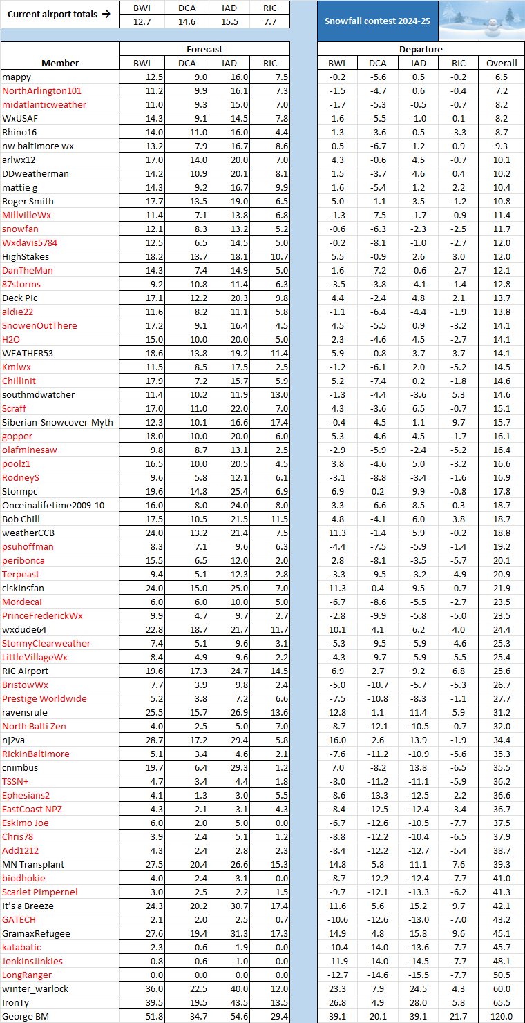
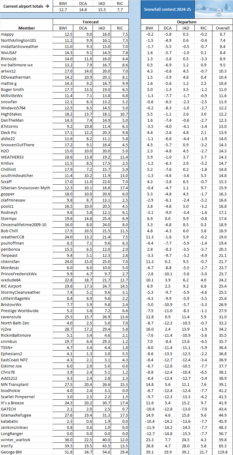
Thanks. What I was going by was Wednesday's daily report for DCA issued at 12:35 AM this morning, which may be found at "Observed Weather" "Daily Climate Report" for "Washington-National" at https://www.weather.gov/wrh/Climate?wfo=lwx. The newest version is currently for Thursday, but you can find the 12:35 AM version for Wednesday by clicking "2" at the top (in blue). It's head-scratching how these contradictions occur, but you are correct that the snow total for yesterday is now back up to 0.5 inches. The below table reflects that change for DCA:

-
The DCA measuring gurus have helped you and a number of other folks by revising downward yesterday's snow total there from 0.5 to 0.3 inches. It would be interesting to know how these revisions come about -- perhaps some of the gurus don't realize that you are not supposed to take snow away from the measuring location to make a snowman? In any event, here is the slightly revised leaderboard, subject to further revisions without warning. P.S. I have listed in red all of the unfortunates who have been eliminated . . . whoops, that includes me.
-
Don't shortchange yourself, @snowfan -- you are currently 12th. Unfortunately, because you have all negative departures, your chance of winning are the same as mine and 38 others -- zero.
-
You aren't out yet, @nw baltimore wx. Your only negative departure is DCA, but the entrants ahead of you aren't doing well there either, and so if you nailed the other three airports you would win.
-
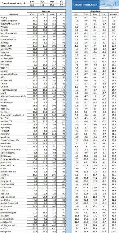
Apparently RIC did receive only 1.0 inch in this storm. However, I was 0.1 over the total at IAD, and so this revision corrects that. Quite a shakeup on the leaderboard, with some unexpected contenders this season. Yes, @Roger Smith, I say that with you in mind. Now, if @George BM gets into contention, @Jebmanwill be wondering why he did not enter.

-
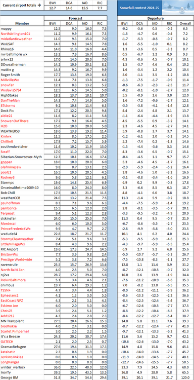
The latest snow totals that I have for the February 11-12th storm are: BWI 3.8, DCA 6.4, IAD 4.9, and RIC 1.0. However, the latter total is likely incomplete, as for some reason the current Wakefield, VA report gives totals for every tiny town, but not RIC. Maybe @RIC Airportknows? Our new leader is @mappy
-
Thanks, Roger. See updated table below
-
Recent January DCA Temperatures Appear Inconsistent with 1981-2010 Normals
RodneyS replied to RodneyS's topic in Mid Atlantic
An illustration of how anomalous the period January 12th-22nd at DCA has been in recent years can be seen by comparing the 1991-2020 daily temperature normals for each day of the year (minus February 29th) calculated by the National Centers for Environmental Information (NCEI), with the actual daily averages during that 30-year period. By far the two largest daily negative anomalies (averages are below the normals) for the calendar year are for January 21st-22nd, and by far the two largest positive anomalies (averages are above the normals) for the calendar year are for January 12th-13th. The below list shows the Top Ten daily temperature anomalies (daily average minus daily normal) at DCA during 1991-2020. It can be seen immediately that there is nothing comparable to the period January 12th-22nd. December 8th-9th has consecutive negative anomalies of -3.28 and -2.97 degrees at DCA, but the largest consecutive December positive anomalies there are not listed below because they are only 1.13 and 2.15 degrees, respectively, on December 22nd-23rd. 1) January 21st -4.43 degrees 2) January 13th +4.37 degrees 3) January 12th +4.32 degrees 4) January 22nd -4.20 degrees 5) February 13th -3.78 degrees 6) December 8th -3.28 degrees 7) March 4th -3.20 degrees 8) April 29th -3.02 degrees 9) December 9th -2.97 degrees 10) April 5th -2.92 degrees I believe that the most plausible explanation here is that the DCA 1991-2020 temperature "normals" calculated by the NCEI for January 12th-13th and January 21st-22nd are not truly normals in any meaningful sense, but are simply the end product of a mathematical process based upon there being no known reason for temperatures on those four calendar days to deviate so significantly from temperatures on nearby calendar days. However, if a reason were to be found, the NCEI would likely have to increase the DCA January 12th-13th normals by about four degrees each and decrease the January 21st-22nd DCA normals by about four degrees each. -
Quite a contrast to two years ago at DCA, even if January did finish on the warm side this year. This year's January average temperature was only 34.2 degrees -- 11 degrees below January 2023. That put DCA not only 3.3 degrees below the 1991-2020 January normal of 37.5, but also 1.2 degrees below the 1871-2025 historical DC average of 35.4. January 2025 tied for only the 92nd warmest January in DC history and was the coldest January at DCA since 32.2 in 2014.
-
February DCA _ NYC _ BOS __ ORD _ ATL _ IAH __ DEN _ PHX _ SEA 1.3 0.9 0.8 0.2 2.5 2.8 1.2 1.7 -4.5
-
Recent January DCA Temperatures Appear Inconsistent with 1981-2010 Normals
RodneyS replied to RodneyS's topic in Mid Atlantic
Thanks for this analysis, Tom. Regarding February in DC in recent years, your memory is spot-on. If you compare DC temperature averages during 1872-1983 and 1984-2024, the average monthly increase from the earlier period to the latter period is 2.7 degrees. But as I think you suspected, February has experienced the largest increase of any month, at 3.6 degrees. December is second largest at 3.5 degrees. So, in keeping with the idea that the winter is being pushed back a couple of months, January must be third largest, right? Wrong! January has the second smallest increase, at only 2.2 degrees. Why? Because while a number of January days have had large daily increases, including the largest of the year on January 13th (7.4 degrees), a number of other January days have experienced temperature decreases, including the largest of the year on January 21st and 22nd (-4.6 degrees on each day). So anyone attempting to calculate recent daily January Temperature Normals in DC is in for a head-spinning experience. Regarding "Winter conditions more common in Mar/Apr, Summer conditions in Sept/Oct" -- the numbers do not support that in DC. Between 1872-1983 and 1984-2024, March has increased 3.1 degrees (3rd largest), and April has increased 3.0 degrees (tied for 4th largest), while September has increased only 2.4 degrees (4th smallest), and October has increased only 2.5 degrees (5th smallest). So, the picture is quite muddled, but January is in a class all its own. FYI, here are each of the average monthly temperature increases in DC from 1872-1983 to 1984-2024 in ascending order: May 1.7, January 2.2, June and September 2.4, October 2.5, November 2.7, July 2.9, April and August 3.0, March 3.1, December 3.5, February 3.6. -
Recent January DCA Temperatures Appear Inconsistent with 1981-2010 Normals
RodneyS replied to RodneyS's topic in Mid Atlantic
Thanks, Tom. I have looked at other January dates, but I thought that the 13th and 21st were the best to illustrate this phenomenon. I remember in the 1980s reading about the "January thaw" that tended to occur in the East around January 21st, which is now the coldest day of the year in DC! However, my analysis is quite simplistic, and so expanding upon it may shed additional light as to what is going on. It's great that some of you younger guys are now taking this seriously. The way science usually progresses is for the older generation, which is in a position of authority, to dismiss any new idea that challenges the conventional wisdom as being unworthy of investigation. But if something is really there, eventually the younger generation will take over that position of authority and make the new idea part of mainstream science. -
Recent January DCA Temperatures Appear Inconsistent with 1981-2010 Normals
RodneyS replied to RodneyS's topic in Mid Atlantic
Hmm, that may be something to look at -- I think the more creative ideas we have here, the better off we are. -
Recent January DCA Temperatures Appear Inconsistent with 1981-2010 Normals
RodneyS replied to RodneyS's topic in Mid Atlantic
The mystery is why this January 13th/21st thaw-freeze scenario began happening about 41 years ago in DC. Between 1872-1983, it was just the opposite, with the temperature rising on average by about 3.5 degrees between these two dates. Suddenly, around 1984, the temperature began falling on average by more than 8 degrees between these two dates, and it's still happening. Because the recent period has coincided with warmer temperatures worldwide, I would guess this phenomenon is somehow related to those warmer temperatures. However, why is it that January 21st in DC has defied the warming trend, by now being more than four degrees colder than it used to be? What is the forcing mechanism that brings about this counter-intuitive result? -
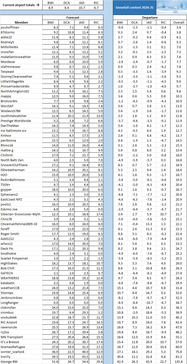
Thanks. That helps a few competitors, including@MillvilleWxand @midatlanticweatherinch up the leaderboard.

-
Recent January DCA Temperatures Appear Inconsistent with 1981-2010 Normals
RodneyS replied to RodneyS's topic in Mid Atlantic
This year on January 13th DCA recorded a minimum of 28 and a maximum of 51 degrees, and on January 21st DCA recorded a minimum of 16 and a maximum of 24 degrees. Those temperatures continue the strong trend toward a lower average temperature on January 21st than on January 13th, and bring both the January 13th and 21st DCA average temperatures for the 12 years that I have now been tracking them (2014-2025) very close to the prior DCA 30-year averages (1984-2013) for those two calendar days. That, in turn, means that the differences at DCA in the January 13th and January 21st average temperatures for 2014-2025 and 1984-2013 are about the same during each period. Specifically, the average temperature at DCA during 2014-2025 for January 21st was 8.8 degrees lower than the average temperature for January 13th, whereas during 1984-2013 that lower difference was 8.2 degrees. That provides even stronger evidence that what I found in January 2013 was not merely an aberration from the first 112 years of daily temperature recordkeeping in DC (1872-1983) -- in which the average temperature was 3.5 degrees higher on January 21st than on January 13th -- but rather a fundamentally new, if currently unexplained, reality: Period Jan 13 Jan 21 Jan 21 minus Jan 13 1872-1983 33.3 36.8 +3.5 1984-2013 40.3 32.1 -8.2 2014-2025 41.3 32.5 -8.8 Note that@Rhino16and I have done some additional research that indicates that a similar January 13th to 21st temperature shift has occured in other Eastern locations in recent years -- see my post of February 20, 2020 and his post of February 28, 2024 above. Does anyone here have a hypothesis as to what is causing this shift or know of someone who is researching this issue? -
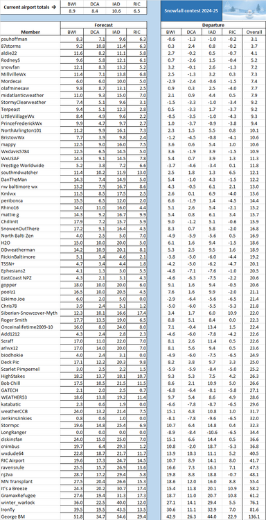
A little more snow yesterday at BWI, DCA, and IAD, but none at RIC -- @psuhoffman is still on top, but now with negative departures at all four airports. So @87stormsis in good position to take the lead with just a tad more snow at BWI, DCA, or IAD, and plenty of contenders are lurking with positive departures at each of those airports.
-
Another 0.1 inch at DCA and 0.3 inches at IAD Thursday evening. No change to the top of the leaderboard, but minor changes further down, as we prepare for perhaps 1-3 inches more on Sunday.
-
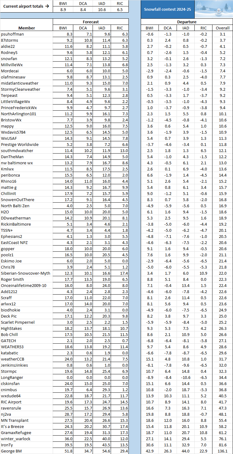
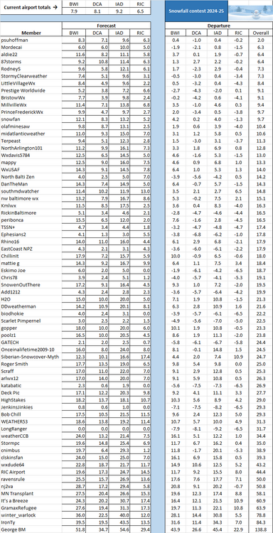
Just as BWI was earlier upgraded to 1.8 inches for this storm and RIC was finalized at 3.0, IAD has now been upgraded to 2.6 inches, and so the 2024-25 seasonal total there is now 8.9. See below revised table, which does not change the leaderboard much:
-
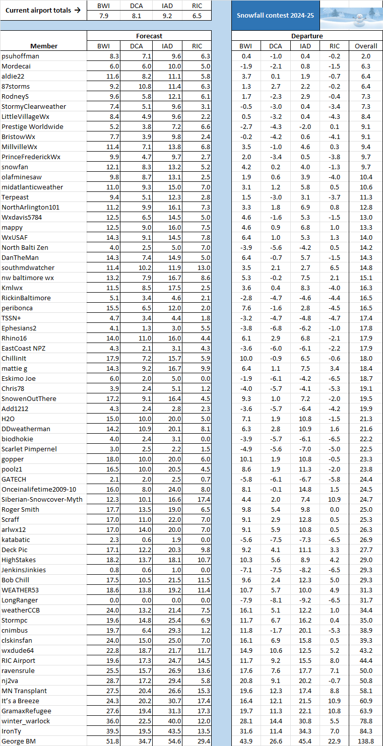
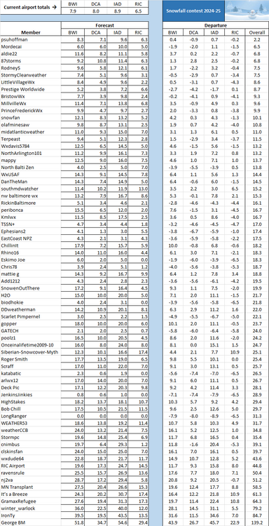
Thanks. Perhaps the snow measuring crew at RIC is inexperienced, and is not following the guidelines set forth here, although snow measurement is as much of an art as it is a science: https://www.weather.gov/gsp/snow