

Allsnow
-
Posts
23,586 -
Joined
-
Last visited
Content Type
Profiles
Blogs
Forums
American Weather
Media Demo
Store
Gallery
Posts posted by Allsnow
-
-
12z euro says enjoy the 80’s this weekend
-
 1
1
-
-
3 hours ago, bluewave said:
Unfortunately, the 6z Euro joined the GFS and GEM with the low cutting off later in the week. But the day to day details for next weekend probably will have to wait.
6z Euro
0z Euro

12z euro moves things along and doesn’t cut it off
-
1
-
-
59 minutes ago, Stormlover74 said:
Let's hope the gfs is wrong for next weekend
It will be….just think of it like it’s the only model showing a snowstorm 7 days out in January
-
5
-
-
Heat and storms….
when’s the next heat push?
-
More rain….
-
8 minutes ago, bluewave said:
The outflow boundary from the MCS may stall out across the area into tomorrow and influence where the sea breeze front sets up. So the actual high temperatures could be a nowcasters special. Seems like every warm up since late March has hit some kind of resistance.
Latest nams keep north jersey below 90 and nyc/LI 70’s
-
 1
1
-
-
33 minutes ago, winterwarlock said:
Looks like im going to luck out between the squeeze play and avoid the storms...storms to north and storms to south..maybe because i was basically cloudy and maybe 75 tops all day
Man these models are brutal
Now im doubting tomorrow's 95 and i bet the sun doesnt show til noon
Wouldnt want to take my chances with cool and clouds at the beaches
Yup. I sure it will take a while to burn off the clouds tomorrow morning.
-
Anything from upton?
-
Mostly sun now
-
 1
1
-
-
Let’s go
-
7 minutes ago, forkyfork said:
the box actually includes the western metro but okx decided to keep us out
Do we break the clouds in time?
-
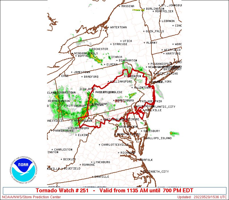
Tornado watch for central nj
-
Humidity dropping here along with the severe threat
-
 1
1
-
-
Biggest bust of our lifetime
-
1
-
1
-
-
2 minutes ago, winterwarlock said:
This looks to be one of the biggest busts of the last 30 years.
Get back out there and mow….
-
1
-
1
-
-
Schools let out early for sun and clouds
-
1
-
2
-
-
Looks like the stuff forming in south central PA will be for the city/south. Stuff in northeast PA will move into Hudson valley
-
Euro held serve at 12z with no heatwave
-
1 hour ago, bluewave said:
Looks like next weekend could continue the onshore flow theme that has been dominating May so far. The Euro has 850 mb temperatures in the +18C to +20C range for Saturday. If the flow went SW, then the warm spots like Newark would easily rise to the mid to upper 90s. But a new wrinkle is showing up in the latest guidance. Subtle warm front forms near the area with SSE sea breezes. This limits the mid 90s potential to Central NJ where the winds go more SW. So places like NYC and LGA could struggle to reach 90°. Newark would be close and could see 90°. But if later runs have more SW flow, then the warmer Euro idea of yesterday would work out.


Yup. Has Long Island now in the 60/70’s next weekend with nyc reaching 80
-
Raining again
-
1
-
 1
1
-
-
One of the worst April may combos of my lifetime….ugly weather
-
2
-
-
30 minutes ago, psv88 said:
I am so sick of this ****ing weather.
This! Awful April and may so far
-
1
-
-
They stole our heatwave
-
4 hours ago, bluewave said:
This has been one of those rare times with easterly flow lasting for 2 weeks.

Killing the fishing currently


May 2022
in New York City Metro
Posted
Yeah, last year it was it the 40’s 50’s