CNY_WX
-
Posts
2,717 -
Joined
-
Last visited
Content Type
Profiles
Blogs
Forums
American Weather
Media Demo
Store
Gallery
Everything posted by CNY_WX
-
I’ve heard snow called “white fertilizer “, lol. When I was an inspector on road construction contractors would hydro seed late in the season, even after it snowed, and they used that expression.
-
Light snow pellets falling here as some lake effect fires up. I don’t think it’s going to amount to much.
-
I see your point. The one home field advantage you didn’t mention is the weather. Of course this year that isn’t as big of an advantage as it could be.
-
Aren’t the Bills still playing for the second best record in the AFC? That would give them potentially 2 home games in the playoffs. I doubt they rest anyone.
-

-
These things have a habit of evening out.
-
It was a very localized area of a foot plus. Freak and me hit the jackpot. Even upstream in the band around Fulton didn’t get as much.
-
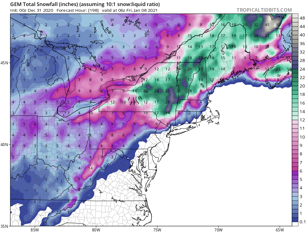
NYZ018-025-036-037-044>046-055>057-062-PAZ039-040-311200- /O.EXT.KBGM.WW.Y.0022.000000T0000Z-201231T1200Z/ Onondaga-Tompkins-Madison-Southern Oneida-Cortland-Chenango- Otsego-Tioga-Broome-Delaware-Sullivan-Susquehanna-Northern Wayne- Including the cities of Syracuse, Ithaca, Hamilton, Oneida, Rome, Utica, Cortland, Norwich, Oneonta, Owego, Waverly, Binghamton, Delhi, Walton, Monticello, Hallstead, Montrose, Damascus, and Equinunk 303 PM EST Wed Dec 30 2020 ...WINTER WEATHER ADVISORY NOW IN EFFECT UNTIL 7 AM EST THURSDAY... * WHAT...Mixed precipitation. Additional snow accumulations of up to one inch and ice accumulations of a light glaze. * WHERE...In Pennsylvania, Susquehanna and Northern Wayne counties. In New York, Sullivan, Tioga, Broome, Delaware, Otsego, Cortland, Onondaga, Tompkins, Chenango, Madison and Southern Oneida counties. * WHEN...Until 7 AM EST Thursday. * IMPACTS...Plan on slippery road conditions. The hazardous conditions could impact the afternoon and evening commute.
-
I’ll take another 13 inches, lol.
-
I don’t know about this “massive” block but the operational Euro shows all the true arctic air retreating above the Arctic Circle by hour 240. All we’re left with as Freak said is old stale modified arctic air. We’re lucky if it supports temperatures in the 30s.
-
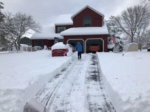
I just came in from snowblowing my driveway. My final “official “ measurement was 13.2 inches of snow. The snow filled my measuring tube and was overflowing the top of the cylinder. I was going to measure any snow that was in the extension of the cylinder but while I was carrying it into the house the snow above the tube fell off. The snow that remained in the tube melted down to 0.48 inch. That would produce a ratio of over 25:1 so I don’t think it’s accurate. Here’s a picture I took while I was clearing the driveway.
-
Rates must have been close to 3”/hr. between 1-5 because like I said there was less than an inch when I went to bed about 12:45.
-
My deck and the path my wife shoveled for the dog. There was less than an inch at 1 AM.
-
81 between Brewerton and Central Square.
-
Our little dog woke up early this morning to go to the bathroom. My wife took her out and after a minute the dog jumped back on the bed. I said what’s going on and she said there’s a foot or two of snow out there. She shoveled a path off our deck and I had to carry the dog out but she at least peed. I went to bed about 1 and there wasn’t even an inch but the band was starting to organize on radar. I’ll get a measurement at 7. It looks like the band is moving southward so I’ll be out of it soon. I put channel 9’s news on and they report a bad tractor trailer crash on 81 at Bartel Rd. 81 is closed. edit: That should read 81 northbound is closed.
-
I got into the southern edge of the band about an hour ago. It looks like I’ll be in and out of heavier snow for now, I’m in a lull right now but that heavier snow shower near Schroppel is headed towards me.
-
-
-
I posted hour 360 of the 6Z GFS which is the end of the run.
-
I think this is what he means. Certainly it’s not brutally cold, more like seasonable cold.
-
Winter Weather Advisory URGENT - WINTER WEATHER MESSAGE National Weather Service Binghamton NY 402 AM EST Mon Dec 28 2020 NYZ018-036-037-290915- /O.NEW.KBGM.WW.Y.0021.201229T0200Z-201229T2100Z/ Onondaga-Madison-Southern Oneida- Including the cities of Syracuse, Hamilton, Oneida, Rome, and Utica 402 AM EST Mon Dec 28 2020 ...WINTER WEATHER ADVISORY IN EFFECT FROM 9 PM THIS EVENING TO 4 PM EST TUESDAY... * WHAT...Snow expected. Total snow accumulations of 3 to 6 inches. * WHERE...Onondaga, Madison and Southern Oneida counties. * WHEN...From 9 PM this evening to 4 PM EST Tuesday. * IMPACTS...Plan on slippery road conditions. The hazardous conditions could impact the morning commute Tuesday. * ADDITIONAL DETAILS...A lake effect snow band will set up east of Lake Ontario late this evening, move south through the Thruway corridor from Syracuse to Utica late tonight and Tuesday morning, then into areas south of Syracuse Tuesday morning into the early afternoon. This band will have snowfall rates of 1 to 2 inches per hour at times between 4 am and 10 am.
-
We’ll make it up in April.
-
I just ran a snowfall summary from my CoCoRaHS records I’ve managed to nickel and dime my way to 12.4 inches since 11/1, the same amount you Buffalo guys received in 4-5 hours yesterday. My single greatest daily accumulation was 3.4 inches. I know we’re only about a quarter of the way through winter but this is frustrating, especially when you look at models hoping to see a sign of hope and see nothing but cutters followed by lake effect that will probably miss my area. I guess we can always hope for a SSW event to shake things up but I won’t believe it until I see it. I’ve had over 6 inches of liquid precipitation which should have translated into 50-60 inches of snow to this point but on 12/27 I look out the window and see green grass. Thanks for letting me rant. * indicates Multi-Day Accumulation Report Station NY-OG-28 Date Precip in. Snowfall in. Snowfall SWE in. Total Snow Depth in. Total SWE in. 11/01/2020 0.00 0.0 NA NA NA 11/02/2020 0.33 0.3 NA NA NA 11/03/2020 0.20 1.0 NA NA NA 11/04/2020 0.00 0.0 NA NA NA 11/05/2020 0.00 0.0 NA NA NA 11/06/2020 0.00 0.0 NA NA NA 11/07/2020 0.00 0.0 NA NA NA 11/08/2020 0.00 0.0 NA NA NA 11/09/2020 0.00 0.0 NA NA NA 11/10/2020 0.00 0.0 NA NA NA 11/11/2020 0.24 0.0 NA NA NA 11/12/2020 0.29 0.0 NA NA NA 11/13/2020 0.00 0.0 NA NA NA 11/14/2020 0.03 0.0 NA NA NA 11/15/2020 0.01 0.0 NA NA NA 11/16/2020 0.23 0.0 NA NA NA 11/17/2020 0.01 T NA NA NA 11/18/2020 0.19 2.4 NA NA NA 11/19/2020 T T NA NA NA 11/20/2020 0.00 0.0 NA NA NA 11/21/2020 0.00 0.0 NA NA NA 11/22/2020 0.00 0.0 NA NA NA 11/23/2020 0.33 T NA NA NA 11/24/2020 0.75 0.4 NA NA NA 11/25/2020 0.01 T NA NA NA 11/26/2020 0.53 0.0 NA NA NA 11/27/2020 0.03 0.0 NA NA NA 11/28/2020 0.08 0.0 NA NA NA 11/29/2020 0.01 0.0 NA NA NA 11/30/2020 0.01 0.0 NA NA NA 12/01/2020 0.38 0.0 NA NA NA 12/02/2020 0.11 0.7 NA NA NA 12/03/2020 0.08 1.4 NA NA NA 12/04/2020 0.00 0.0 NA NA NA 12/05/2020 0.12 0.0 NA NA NA 12/06/2020 0.02 0.1 NA NA NA 12/07/2020 -- -- -- -- -- 12/08/2020 T T NA NA NA 12/09/2020 0.08 0.8 NA NA NA 12/10/2020 0.20 0.7 NA NA NA 12/11/2020 0.02 0.0 NA NA NA 12/12/2020 0.00 0.0 NA NA NA 12/13/2020 T 0.0 NA NA NA 12/14/2020 0.00 0.0 NA NA NA 12/15/2020 0.03 0.3 NA NA NA 12/16/2020 -- -- -- -- -- 12/17/2020 0.36 3.4 NA NA NA 12/18/2020 0.01 0.1 NA NA NA 12/19/2020 0.00 0.0 NA NA NA 12/20/2020 0.02 0.3 NA NA NA 12/21/2020 0.10 0.2 NA NA NA 12/22/2020 0.04 0.0 NA NA NA 12/23/2020 T T NA NA NA 12/24/2020 0.00 0.0 NA NA NA 12/25/2020 1.17 0.0 NA NA NA 12/26/2020 0.10 0.3 NA NA NA 12/27/2020 T T NA NA NA Totals : 6.12 in. 12.4 in. 0.00 in. -- -- For questions or comments concerning this web page please contact [email protected]. Unless otherwise noted, all content on the CoCoRaHS website is released under a Creative Commons Attribution 3.0 License. Privacy Policy Data Usage Policy Copyright © 1998-2020, Colorado Climate Center, All rights reserved.
-

Major LES event-December 24-27
CNY_WX replied to BuffaloWeather's topic in Upstate New York/Pennsylvania
Get ready, Wolfie. Here it comes! -
Major LES event-December 24-27
CNY_WX replied to BuffaloWeather's topic in Upstate New York/Pennsylvania
Hey BW, your neighbor is out with his snowblower - you better get busy, lol!