

CNY_WX
-
Posts
2,717 -
Joined
-
Last visited
Content Type
Profiles
Blogs
Forums
American Weather
Media Demo
Store
Gallery
Everything posted by CNY_WX
-

Upstate NY Banter and General Discussion..
CNY_WX replied to wolfie09's topic in Upstate New York/Pennsylvania
Who is that guy? Nice mouth on him. -
I’ve been busy this morning so this is a little late. I picked up another 1.4 inches of snow overnight so my total for the “storm “ is 5.6 inches. Melted down the LE was 0.41 inch which gives a ratio of 13.66:1. Looking at the CoCoRaHS reports from Onondaga County the ratios are all over the place. I don’t know if people had problems measuring the snow but my ratio is within the range.
-
Where’s Matt?
-
Upstate NY Banter and General Discussion..
CNY_WX replied to wolfie09's topic in Upstate New York/Pennsylvania
Here’s another link: https://apple.news/A_mLuciWfQ_6Cvo8cE28kPg -
Upstate NY Banter and General Discussion..
CNY_WX replied to wolfie09's topic in Upstate New York/Pennsylvania
For all the day traders: https://www.wsj.com/articles/gamestop-stock-short-squeeze-ugly-side-11611750250?mod=hp_lead_pos5 -
********************STORM TOTAL SNOWFALL******************** LOCATION TOTAL TIME/DATE COMMENTS SNOWFALL MEASURED (inches) NEW YORK ...Broome County... Binghamton 2.2 645 PM 1/26 Official NWS Obs Endwell 2.0 300 PM 1/26 NWS Employee 3 SE Chenango Forks 1.9 245 PM 1/26 CoCoRaHS Nineveh 1.7 350 PM 1/26 Trained Spotter 2 S Vestal 1.0 1100 AM 1/26 NWS Employee ...Cayuga County... 1 WNW Levanna 1.7 1210 PM 1/26 sleet mixed in ...Chemung County... Elmira 1.0 220 PM 1/26 Mixed with sleet ...Madison County... Oneida 4.0 425 PM 1/26 Trained Spotter Chittenango 3.0 701 PM 1/26 Trained Spotter ...Oneida County... Lee 6.0 540 PM 1/26 Social Media Holland Patent 4.0 502 PM 1/26 Trained Spotter Whitesboro 4.0 453 PM 1/26 Social Media Utica 3.8 530 PM 1/26 Social Media Paris 3.2 553 PM 1/26 Trained Spotter Deerfield 3.0 357 PM 1/26 Social Media ...Onondaga County... Brewerton 4.2 500 PM 1/26 CoCoRaHS Marcellus 3.5 312 PM 1/26 Social Media Baldwinsville 3.0 347 PM 1/26 Broadcast Media Syracuse 2.6 500 PM 1/26 Local Official ...Otsego County... Unadilla 3.3 400 PM 1/26 Elevation 1500` Oneonta 3.0 630 PM 1/26 Elevation 1440` ...Sullivan County... 3 NE North Branch 2.0 550 PM 1/26 Co-Op Observer ...Tioga County... Tioga Terrace 2.5 335 PM 1/26 Trained Spotter Apalachin 1.5 230 PM 1/26 raining now ...Tompkins County... Newfield 0.9 430 PM 1/26 Elevation 1850` The 4.2 inches at Brewerton is my measurement.
-
I had 4.2 inches as of 5 PM and the on and off snow showers since then has me pushing 5 inches which is within my expectations.
-
Use your leaf blower instead of a shovel, lol.
-
Tonight marks 4 weeks of a continuous snow cover in Brewerton starting with 13.2 inches of lake effect on 12/29. What seems to be a crappy winter has at least given the appearance of winter with the ground being white.
-
Looks like a little burst at KBUF. Visibility is down to 3/4 mile.
-
I measured at 5 PM and have a total of 4.2 inches. It’s still snowing with some sleet mixed in.
-
Hoping to make it to 4 inches. Definitely over 3 right now.
-
Syracuse airport is reporting -SNGS in their latest report. I don’t think I’ve ever seen GS in a report before. The decoded metar reports it as light snow and unknown precipitation. I thought unknown precipitation was UP. BTW it’s snowing heavily again.
-
This area has developed right behind the main band so it will continue snowing fora while
-
Lightening up now but still snowing. Just under 3 inches in exactly 2 hours.
-
I’m hoping that will make it up to my area later.
-
If only this could keep up for a couple more hours...
-
One last thump before we get dry slotted. Currently really coming down probably approaching 2 inches. John DiPasquale on his noon forecast kinda threw in the towel at the end of the show and said the dry slot might keep us from reaching the 4-6 inches forecast. He also said the snow should redevelop later although lighter.
-
I don’t know what it’s doing where you are but currently it’s snowing heavily here.
-
I’m surprised more of you don’t invest in RadarScope. I’ve used it for several years and after purchasing the app for, I think, $10 it provide radar data for many different parameters. The big drawback is that you can only view one site at a time. There are upgraded levels you can subscribe to.
-
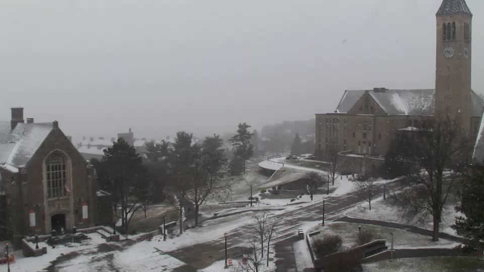
Snowing pretty good in Ithaca on the Cornell campus. The ground was bare less than an hour ago.
-
It just started snowing on the Syracuse University campus (Eggers Hall Quadcam). It should be up here within the next half hour.
-
I’m about as far north as you can be in the BGM forecast area and might as well be in Siberia as far as mesoscale events are concerned. There have been lake snow events that are entirely north of the route 31 corridor that Binghamton totally ignores. Before the NWS consolidated there was a forecast office at KSYR. I’m sure the weather in northern Onondaga County wasn’t ignored then.
-
The CNYcentral (channels 3&5) forecast give some love to Dave, Tim and all of us in northern Onondaga County and southern Oswego County
-
What I hate is when they use their in house model to produce a snowfall map then despite what it puts out they give their standard forecast. You could have the model put 8 inches over your area then they will give a general forecast of 3-5 and just ignore the model. Why even use the model then? Just draw a map showing what your forecast is.


