SchaumburgStormer
-
Posts
5,847 -
Joined
-
Last visited
Content Type
Profiles
Blogs
Forums
American Weather
Media Demo
Store
Gallery
Everything posted by SchaumburgStormer
-

Pre-Christmas (Dec 21-23rd) Winter Storm
SchaumburgStormer replied to Chicago Storm's topic in Lakes/Ohio Valley
Bit deeper, and a bit further west. At the IL/IN border at 114 -
Pre-Christmas (Dec 21-23rd) Winter Storm
SchaumburgStormer replied to Chicago Storm's topic in Lakes/Ohio Valley
18z GFS going big again -
Pre-Christmas (Dec 21-23rd) Winter Storm
SchaumburgStormer replied to Chicago Storm's topic in Lakes/Ohio Valley
What air temps did we have for GHD1? I assume this is much colder. Would be some seriously life threatening conditions with the progged cold if we end up with another LSD parking lot -
Pre-Christmas (Dec 21-23rd) Winter Storm
SchaumburgStormer replied to Chicago Storm's topic in Lakes/Ohio Valley
Coming together, lots of details to work out and small changes will make wild sensible weather changes for some folks. But high confidence for a very high impact event.
-
Pre-Christmas (Dec 21-23rd) Winter Storm
SchaumburgStormer replied to Chicago Storm's topic in Lakes/Ohio Valley
Euro is hawt -
Pre-Christmas (Dec 21-23rd) Winter Storm
SchaumburgStormer replied to Chicago Storm's topic in Lakes/Ohio Valley
Probably ground blizzard conditions until Monday. Good luck trying to travel -
Pre-Christmas (Dec 21-23rd) Winter Storm
SchaumburgStormer replied to Chicago Storm's topic in Lakes/Ohio Valley
The trend is our friend…
-
Pre-Christmas (Dec 21-23rd) Winter Storm
SchaumburgStormer replied to Chicago Storm's topic in Lakes/Ohio Valley
Low is 50 miles west of the previous run. Baby steps west and capitulation to the euro continue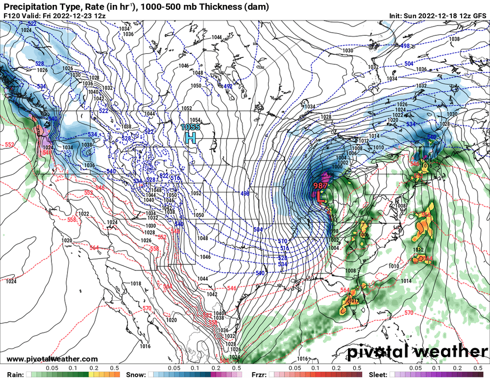
-
Pre-Christmas (Dec 21-23rd) Winter Storm
SchaumburgStormer replied to Chicago Storm's topic in Lakes/Ohio Valley
Wave digging a bit further south and a touch deeper. Going to likely be coming west gonna be a nice run for Chicagoland -
Pre-Christmas (Dec 21-23rd) Winter Storm
SchaumburgStormer replied to Chicago Storm's topic in Lakes/Ohio Valley
Definitely ticking west a bit as a few more members jump on the “more amped” train. -
Pre-Christmas (Dec 21-23rd) Winter Storm
SchaumburgStormer replied to Chicago Storm's topic in Lakes/Ohio Valley
Really, given the last couple years the fact the ground is white is a win. Anything above that is gravy. Plenty of time to reel this one in #weenie -
Pre-Christmas (Dec 21-23rd) Winter Storm
SchaumburgStormer replied to Chicago Storm's topic in Lakes/Ohio Valley
Until the GFS gives us a reason to believe it, it has been awful. So I would at least put more weight in the non-GFS solutions until we get more data -
Pre-Christmas (Dec 21-23rd) Winter Storm
SchaumburgStormer replied to Chicago Storm's topic in Lakes/Ohio Valley
Gfs looking similar to 12z, maybe a touch north/west edit: nope, riding the same line thru 126 -
Pre-Christmas (Dec 21-23rd) Winter Storm
SchaumburgStormer replied to Chicago Storm's topic in Lakes/Ohio Valley
Yup. Classic Chicago storm track. Plenty of details to refine, but my confidence is growing for at least a warning level storm. Let’s just avoid the 48 hr disappearing act which was the name of the game the past few years… -
Pre-Christmas (Dec 21-23rd) Winter Storm
SchaumburgStormer replied to Chicago Storm's topic in Lakes/Ohio Valley
24-30 hour duration over the major travel days. Eek -
Pre-Christmas (Dec 21-23rd) Winter Storm
SchaumburgStormer replied to Chicago Storm's topic in Lakes/Ohio Valley
Euro taking the STL to South Bend Path, looks great for N IL/WI. -
Pre-Christmas (Dec 21-23rd) Winter Storm
SchaumburgStormer replied to Chicago Storm's topic in Lakes/Ohio Valley

-
Pre-Christmas (Dec 21-23rd) Winter Storm
SchaumburgStormer replied to Chicago Storm's topic in Lakes/Ohio Valley
Shatters the flakes. GHD1 was pins and needles. -
Pre-Christmas (Dec 21-23rd) Winter Storm
SchaumburgStormer replied to Chicago Storm's topic in Lakes/Ohio Valley
Regardless of the amount of snow, winds are going to make travel damn near impossible. Even 4-6” with 40-50mph winds would pull the plows from the roads. Jump that to double digits and you have a true paralyzing blizzard. -
Pre-Christmas (Dec 21-23rd) Winter Storm
SchaumburgStormer replied to Chicago Storm's topic in Lakes/Ohio Valley
More or less because when they start panty dropping, the board breaks… -
Pre-Christmas (Dec 21-23rd) Winter Storm
SchaumburgStormer replied to Chicago Storm's topic in Lakes/Ohio Valley
True. American. Consistency. -
Pre-Christmas (Dec 21-23rd) Winter Storm
SchaumburgStormer replied to Chicago Storm's topic in Lakes/Ohio Valley
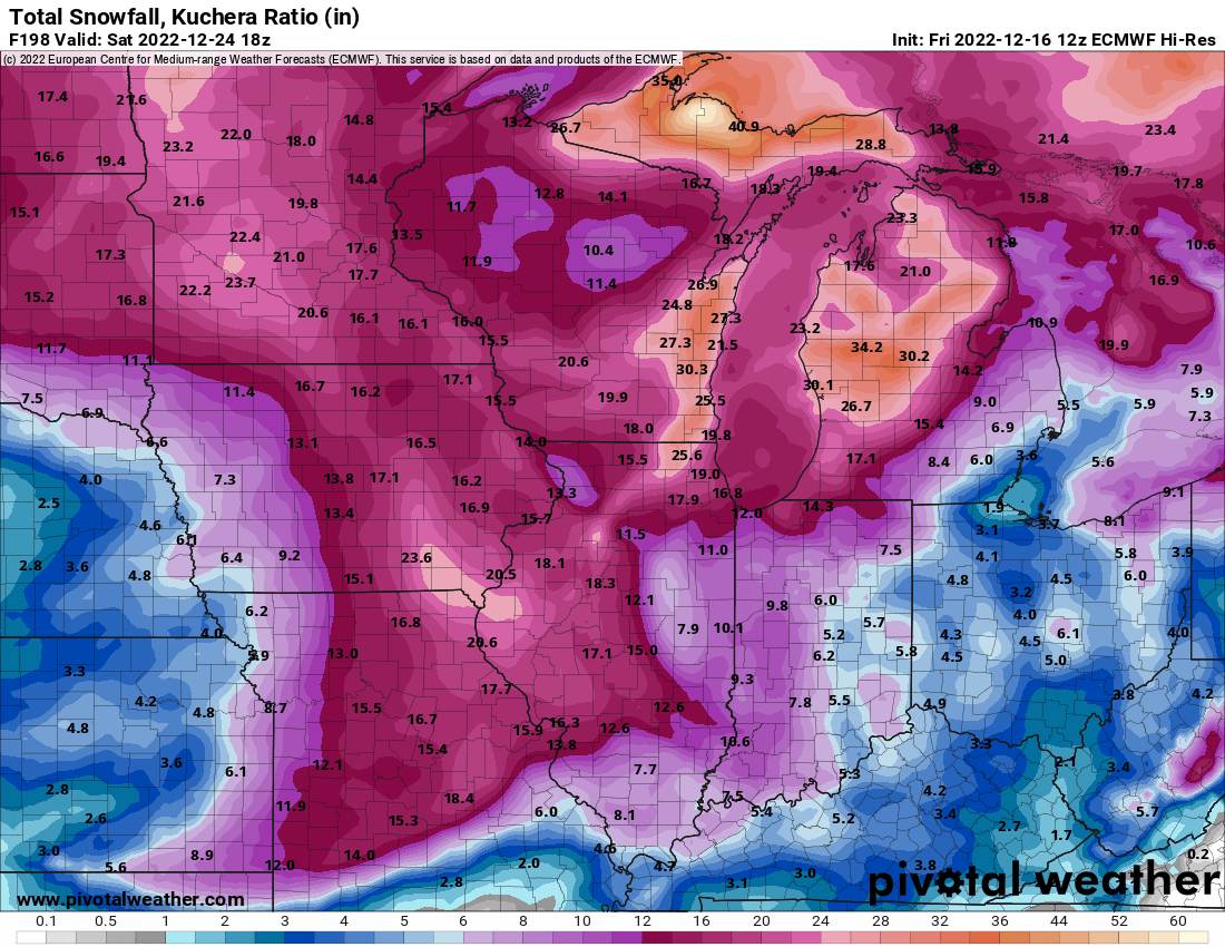
Yeah, about as big of broad brush of a 8+” as you can get area wide through Christmas Day regardless of how it plays out, I am getting pretty confident in seeing my first white Christmas in a few years -
Pre-Christmas (Dec 21-23rd) Winter Storm
SchaumburgStormer replied to Chicago Storm's topic in Lakes/Ohio Valley
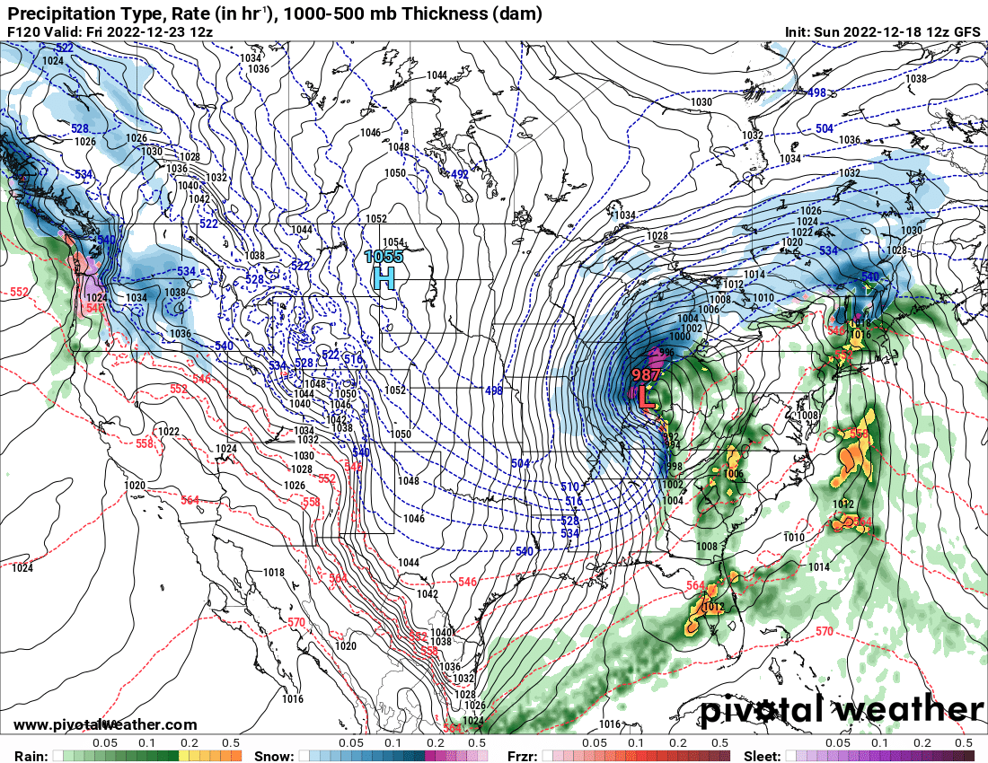
We may as well slap at least one map up for posterity… and the winds…
-
Pre-Christmas (Dec 21-23rd) Winter Storm
SchaumburgStormer replied to Chicago Storm's topic in Lakes/Ohio Valley
Didnt we have repeated GFS vs. Everyone standoffs last year with last second (within 48 hr) caves repeatedly by the GFS? We will see if the "upgrade" does anything, but certainly not putting much weight in any solution (and even less with a GFS outlier). -
Winter 2022/23 Medium/Long Range Discussion
SchaumburgStormer replied to Chicago Storm's topic in Lakes/Ohio Valley
Wonderful run to run consistency, NYC goes from 0" on 06z to 2 feet on this run.