SchaumburgStormer
-
Posts
5,847 -
Joined
-
Last visited
Content Type
Profiles
Blogs
Forums
American Weather
Media Demo
Store
Gallery
Everything posted by SchaumburgStormer
-

Pre-Christmas (Dec 21-23rd) Winter Storm
SchaumburgStormer replied to Chicago Storm's topic in Lakes/Ohio Valley
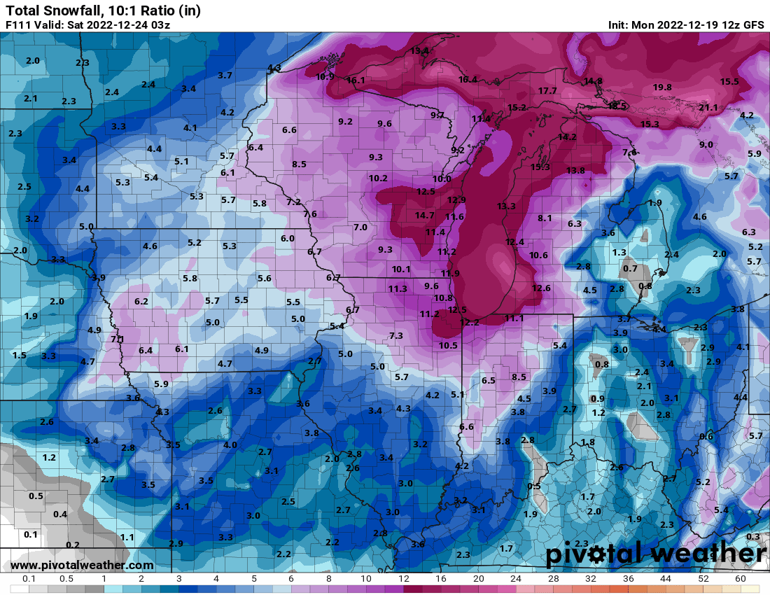
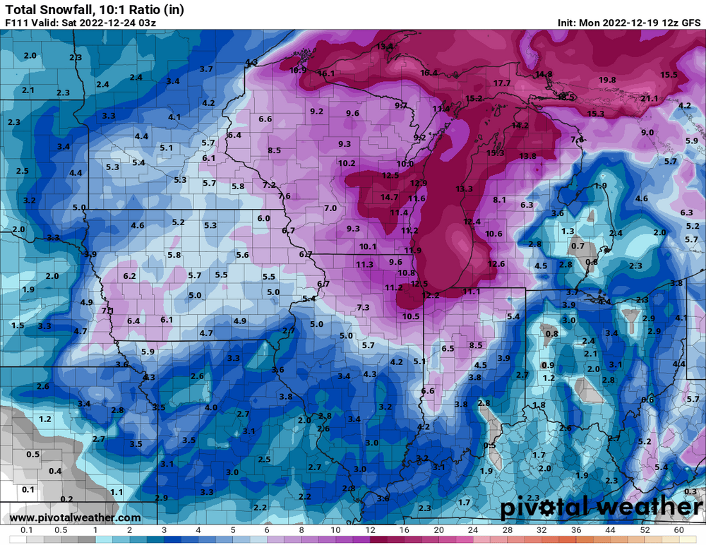
Yes. And even the less amped 18z euro is an 8-10” storm area wide. -
Pre-Christmas (Dec 21-23rd) Winter Storm
SchaumburgStormer replied to Chicago Storm's topic in Lakes/Ohio Valley
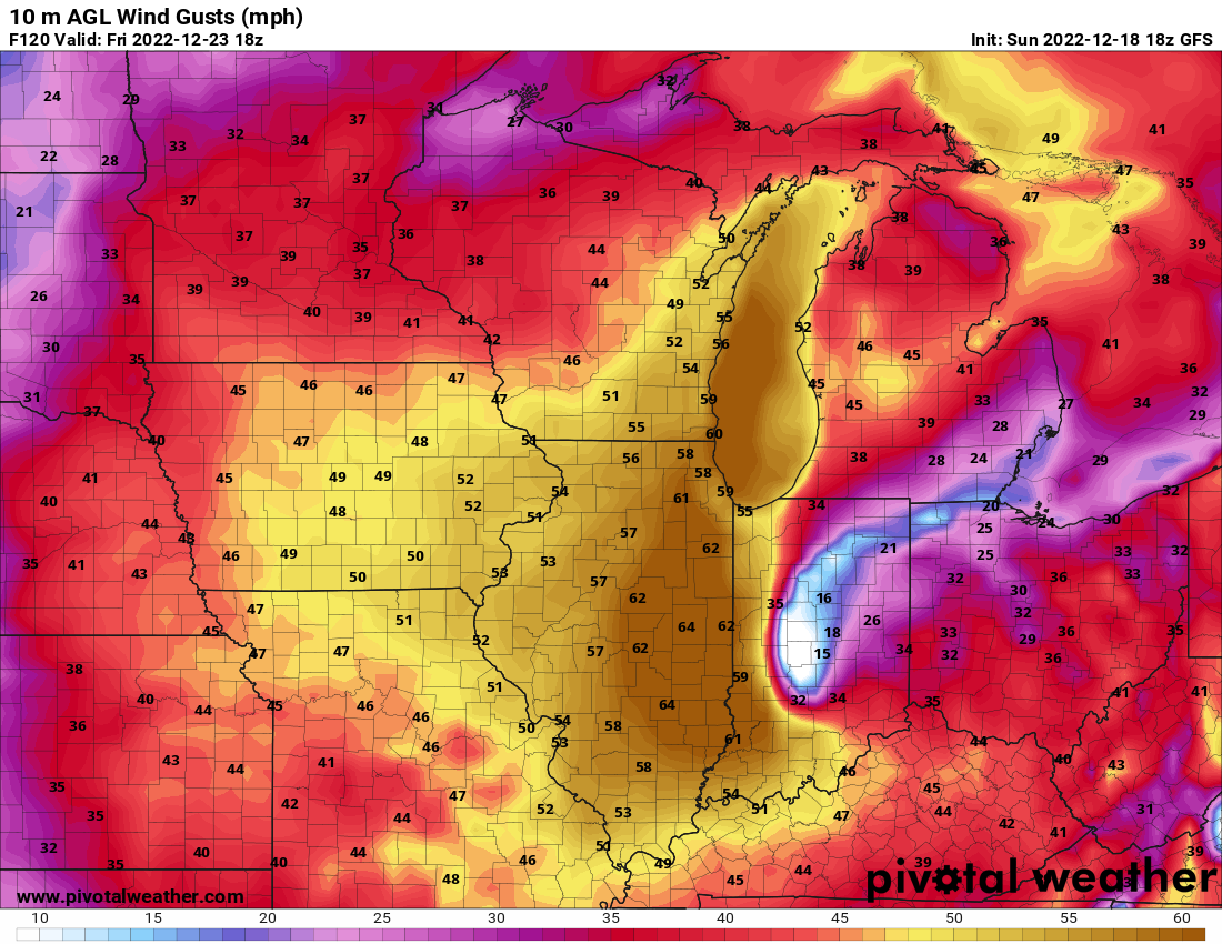
18z is still a major blizzard in Chicago on a extremely heavy travel day. -
Pre-Christmas (Dec 21-23rd) Winter Storm
SchaumburgStormer replied to Chicago Storm's topic in Lakes/Ohio Valley
Map is getting "that look" -
Pre-Christmas (Dec 21-23rd) Winter Storm
SchaumburgStormer replied to Chicago Storm's topic in Lakes/Ohio Valley
With the talk of 10:1 being underdone, this will do. -
Pre-Christmas (Dec 21-23rd) Winter Storm
SchaumburgStormer replied to Chicago Storm's topic in Lakes/Ohio Valley
You're correct, I was looking at an older run. -
Pre-Christmas (Dec 21-23rd) Winter Storm
SchaumburgStormer replied to Chicago Storm's topic in Lakes/Ohio Valley
GFS looks west. Low right in central IL at 72 -
Pre-Christmas (Dec 21-23rd) Winter Storm
SchaumburgStormer replied to Chicago Storm's topic in Lakes/Ohio Valley
Banking on higher ratios? -
Pre-Christmas (Dec 21-23rd) Winter Storm
SchaumburgStormer replied to Chicago Storm's topic in Lakes/Ohio Valley
Then ends up way west going straight up lake michigan. NAM gonna NAM -
Pre-Christmas (Dec 21-23rd) Winter Storm
SchaumburgStormer replied to Chicago Storm's topic in Lakes/Ohio Valley
Has the low ping ponging all over IL and IN -
Pre-Christmas (Dec 21-23rd) Winter Storm
SchaumburgStormer replied to Chicago Storm's topic in Lakes/Ohio Valley
I wonder if there was some talk between offices to get it out there early across the board due to the travel impacts. -
Pre-Christmas (Dec 21-23rd) Winter Storm
SchaumburgStormer replied to Chicago Storm's topic in Lakes/Ohio Valley
Widespread 8-12" across LOT's CWA. -
Pre-Christmas (Dec 21-23rd) Winter Storm
SchaumburgStormer replied to Chicago Storm's topic in Lakes/Ohio Valley
Tracks from Paducah to South Bend. Pretty classic landing spot for a significant chicago storm. -
Pre-Christmas (Dec 21-23rd) Winter Storm
SchaumburgStormer replied to Chicago Storm's topic in Lakes/Ohio Valley
12z thats running now, yeah. -
Pre-Christmas (Dec 21-23rd) Winter Storm
SchaumburgStormer replied to Chicago Storm's topic in Lakes/Ohio Valley
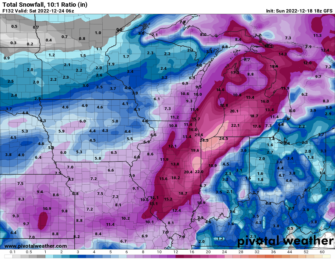
Euro looks like another big run for Chicago depending on when the low starts bombing out. -
Pre-Christmas (Dec 21-23rd) Winter Storm
SchaumburgStormer replied to Chicago Storm's topic in Lakes/Ohio Valley
Over. -
Pre-Christmas (Dec 21-23rd) Winter Storm
SchaumburgStormer replied to Chicago Storm's topic in Lakes/Ohio Valley
To a certain extent, once your above 4” accumulation is not going to massively change sensible weather conditions. It’s going to be a blizzard. -
Pre-Christmas (Dec 21-23rd) Winter Storm
SchaumburgStormer replied to Chicago Storm's topic in Lakes/Ohio Valley
-
Pre-Christmas (Dec 21-23rd) Winter Storm
SchaumburgStormer replied to Chicago Storm's topic in Lakes/Ohio Valley
It’s bonkers that we are “disappointed” with advisory-to-low end warning snows shown on a model a couple days before Christmas. -
Pre-Christmas (Dec 21-23rd) Winter Storm
SchaumburgStormer replied to Chicago Storm's topic in Lakes/Ohio Valley
As long as we dont pull a sudden vanishing act within 48 where an open wave goes through the deep south... -
Pre-Christmas (Dec 21-23rd) Winter Storm
SchaumburgStormer replied to Chicago Storm's topic in Lakes/Ohio Valley
Absolute jackpot run for MBY. Would be a wild solution, but the shitty GFS may be overcorrecting at this range now.... Cant put much weight into it as it was in the Atlantic 30 hours ago. Waiting for king Euro. -
Pre-Christmas (Dec 21-23rd) Winter Storm
SchaumburgStormer replied to Chicago Storm's topic in Lakes/Ohio Valley
Lots of factors at play, but slower gives the lead wave time to scoot out allowing for our wave to intensify. So slower evolution is probably a stronger, more north solution -
Pre-Christmas (Dec 21-23rd) Winter Storm
SchaumburgStormer replied to Chicago Storm's topic in Lakes/Ohio Valley
I’m not sure much travel is happening until Sunday or Monday if these maps verify -
Pre-Christmas (Dec 21-23rd) Winter Storm
SchaumburgStormer replied to Chicago Storm's topic in Lakes/Ohio Valley

-
Pre-Christmas (Dec 21-23rd) Winter Storm
SchaumburgStormer replied to Chicago Storm's topic in Lakes/Ohio Valley
Kuchera for the lolz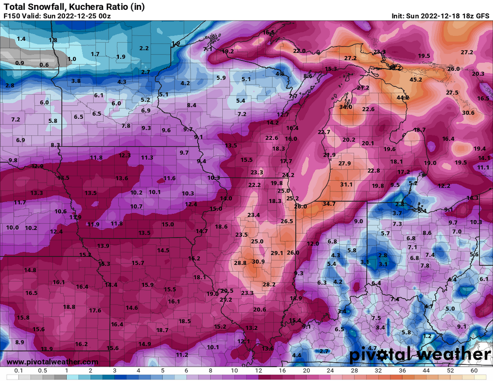
-
Pre-Christmas (Dec 21-23rd) Winter Storm
SchaumburgStormer replied to Chicago Storm's topic in Lakes/Ohio Valley
Crush job. Still snowing in IN/MI.