

SchaumburgStormer
-
Posts
5,198 -
Joined
-
Last visited
Content Type
Profiles
Blogs
Forums
American Weather
Media Demo
Store
Gallery
Posts posted by SchaumburgStormer
-
-
5 minutes ago, Chicago Storm said:
If you’re in NE Illinois or the metro, I would have concerns about a last minute shift north and that the front end thump was the main show…
Short term guidance is definitely giving that indication

-
I love short term guidance. HRRR has no fucking clue as to what going to happen as the low scoots by, so the backside snow changes rapidly from run to run. Nowcast time!
-
8 minutes ago, SchaumburgStormer said:
Definitely have some concern looking at short term guidance that we stay sleet/mix longer than I thought yesterday and really knock down accums
No sooner did I complain, Mother Nature made a mockery of me and switched back to snow. Small flake size but snow nonetheless
-
 1
1
-
-
Definitely have some concern looking at short term guidance that we stay sleet/mix longer than I thought yesterday and really knock down accums
-
6.4” down with the first wave, now getting a snow/sleet mix
-
4
-
-
-
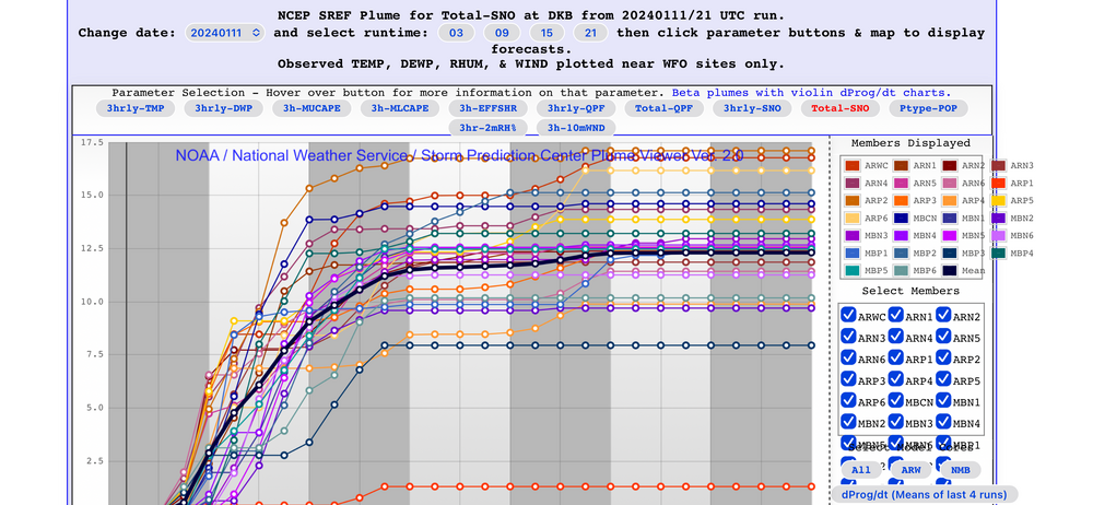
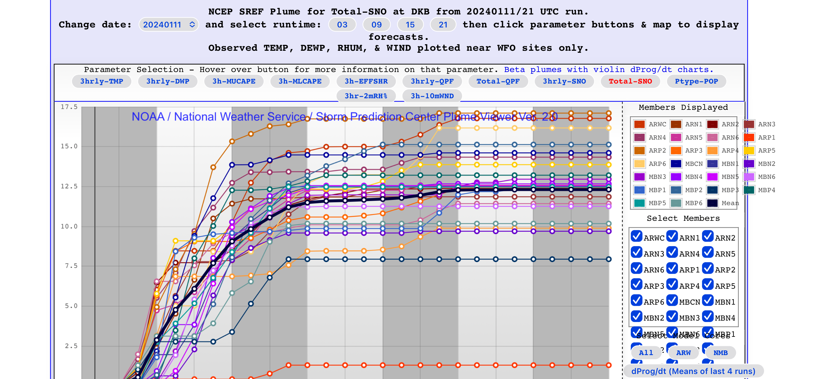
For old times sake, gotta post at least one plume spread…
-
3
-
-
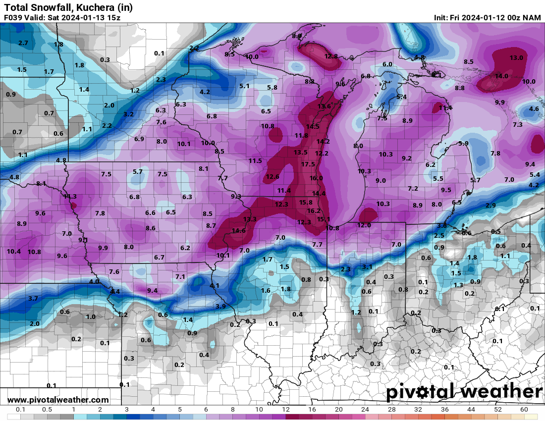
Only hr 12 and the NAM appears south already.
-
 1
1
-
-
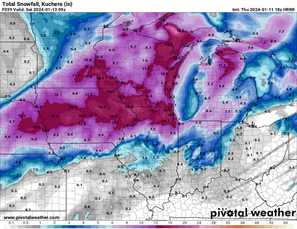
If the wraparound snow comes to fruition like the HRRR is suggesting, double digits easy damn near across all of LOT.

-
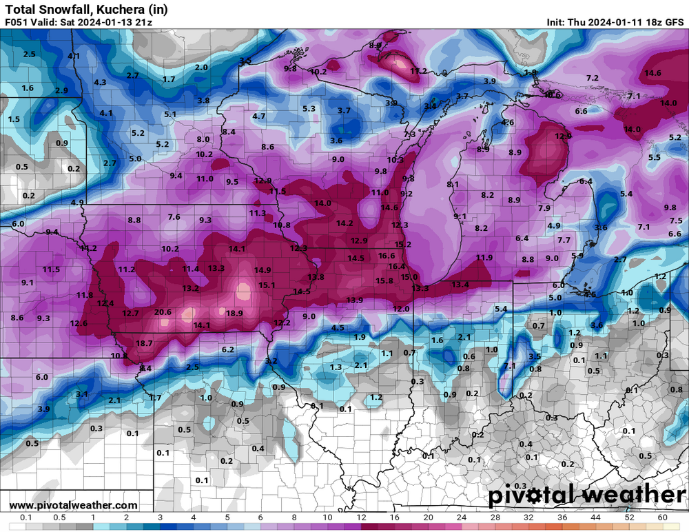
00z HRRR going to be another hot one for the metro. Widespread 8”+ with the backside just starting to pivot around
-
1
-
-
1 minute ago, Radtechwxman said:
I actually felt like it came nw. Has kind of a barrel double low then one takes over further east. Nam/rap/hrrr were hinting at this at times. Maybe they were right. The snow gradient across Peoria County is comical.
Would be wild if it played out as progged on the GFS. Downtown and the riverfront get 2-3” while the north side of the metro has 8-12”
-
13 minutes ago, ILSNOW said:
These GFS snow numbers are at basically an 8:1 ratio for almost the entire event. Storm does have great potential but would have one for the books if we had a cold air mass in place with 12 or 14:1 ratios.

You aren’t kidding. Would be widespread 20-24”+ totals.
-
Well we have some consistency. Let’s get the ole king on board.

-
3
-
-
Just now, ChiTownSnow said:
nope.. nope. not doing that. that failed me last time
You didn’t believe hard enough. This bunker runs on weenie dreams and NAM clown maps
-
Back to the bunker folks.
-
4
-
-
-
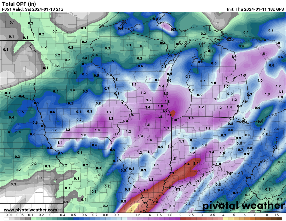
FWIW, GFS seems a touch south and east
-
Really enjoying back to back storms with daytime snow. Seems like the last few years the majority of the snow locally fell overnight
-
3
-
-
1 minute ago, metallica470 said:
Latest LOT snowfall map:
Been a hot minute since I have cracked double digits. Let’s gooo
-
2
-
-
Big swath of blizzard warnings across iowa
-
1
-
-
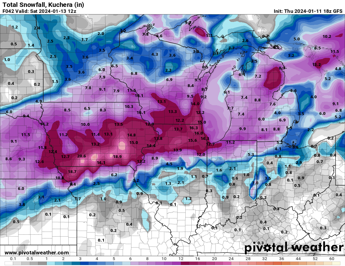
1 minute ago, SchaumburgStormer said:
I’ll have what she’s having…
Sorry lakefront, you only get 8”
-
I’ll have what she’s having…
-
2
-
 1
1
-
-
Jesus. Still snowing in N IL at hr 36.
-
1 minute ago, NEILwxbo said:
The HRRR/RAP are both crushers for N IL. TSSN a possibility for sure. HRRR gives us 5-9" just during morning hours...
This run is going to be a thing of beauty for NE IL. Still absolutely ripping at hr 26
-
2
-


Jan 11-13th Blizzard
in Lakes/Ohio Valley
Posted
At 8.2” here. Hit my call, anything over this is gravy now.