

SchaumburgStormer
-
Posts
5,198 -
Joined
-
Last visited
Content Type
Profiles
Blogs
Forums
American Weather
Media Demo
Store
Gallery
Posts posted by SchaumburgStormer
-
-
Absolute top notch weather coming for the foreseeable. Mid-70's occasional storm chances. #chefskiss
-
 5
5
-
-
Only .71" over the past 3 days. Not exactly a washout.
-
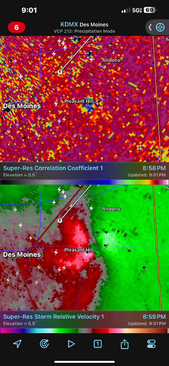
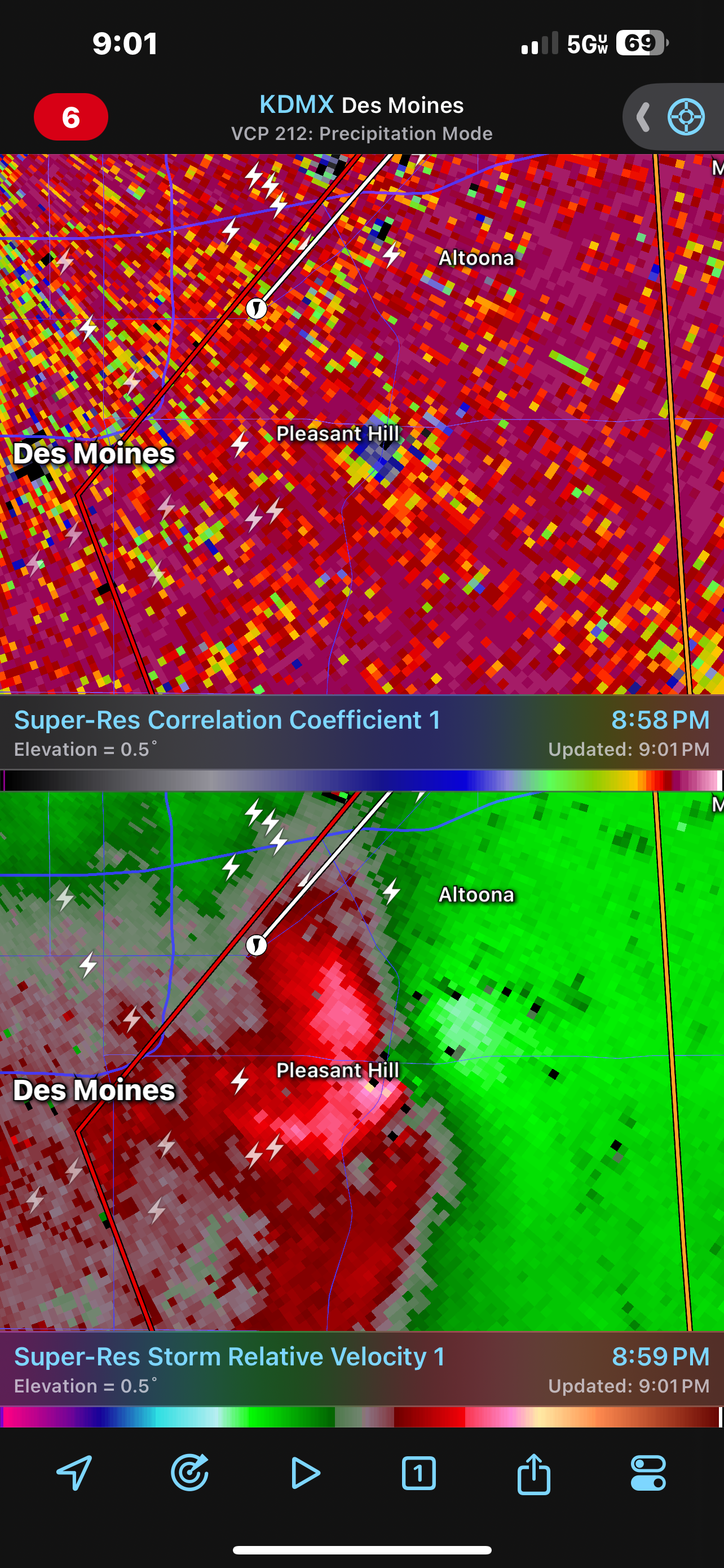
Another TDS east of Des Moines
-
1
-
-
2 minutes ago, yoda said:
Severe Weather Statement
National Weather Service Des Moines IA
857 PM CDT Fri Apr 26 2024

IAC099-153-270230-
/O.CON.KDMX.TO.W.0023.000000T0000Z-240427T0230Z/
Polk IA-Jasper IA-
857 PM CDT Fri Apr 26 2024

...A TORNADO WARNING REMAINS IN EFFECT UNTIL 930 PM CDT FOR
SOUTHEASTERN POLK AND WESTERN JASPER COUNTIES...

At 857 PM CDT, a confirmed large and extremely dangerous tornado was
located over Pleasant Hill, moving northeast at 35 mph.

This is a PARTICULARLY DANGEROUS SITUATION. TAKE COVER NOW!

HAZARD...Damaging tornado.

SOURCE...Radar confirmed tornado.

IMPACT...You are in a life-threatening situation. Flying debris may
         be deadly to those caught without shelter. Mobile homes
         will be destroyed. Considerable damage to homes,
         businesses, and vehicles is likely and complete destruction
         is possible.

The tornado will be near...
  Des Moines, Altoona, Pleasant Hill, Bondurant, Adventureland
  Amusement Park, and Prairie Meadows around 900 PM CDT.
  Mitchellville around 905 PM CDT.
  Valeria around 915 PM CDT.
  Colfax around 920 PM CDT.
  Mingo around 925 PM CDT.

Other locations impacted by this tornadic thunderstorm include Mingo,
Valeria, and Runnells.

This includes the following highways...
 Interstate 80 between mile markers 140 and 155.
 Interstate 235 between mile markers 10 and 12.

PRECAUTIONARY/PREPAREDNESS ACTIONS...

To repeat, a large, extremely dangerous and potentially deadly
tornado is on the ground. To protect your life, TAKE COVER NOW! Move
to a basement or an interior room on the lowest floor of a sturdy
building. Avoid windows. If you are outdoors, in a mobile home, or in
a vehicle, move to the closest substantial shelter and protect
yourself from flying debris.

Heavy rainfall may hide this tornado. Do not wait to see or hear the
tornado. TAKE COVER NOW!

Tornadoes are extremely difficult to see and confirm at night. Do not
wait to see or hear the tornado. TAKE COVER NOW!
Rain wrapped too.
-
Yikes, she’s chewing.
-
1
-
-
Just now, SchaumburgStormer said:
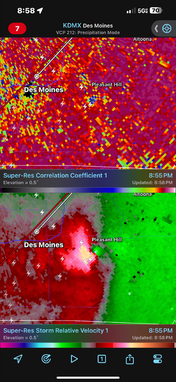
TOG east of Des Moines
-
TOG east of Des Moines
-
Storm near Osceola looks nasty
-
Yep dropped to 26 IMBY. Wasn’t expecting it to go quite that low
-
 2
2
-
-
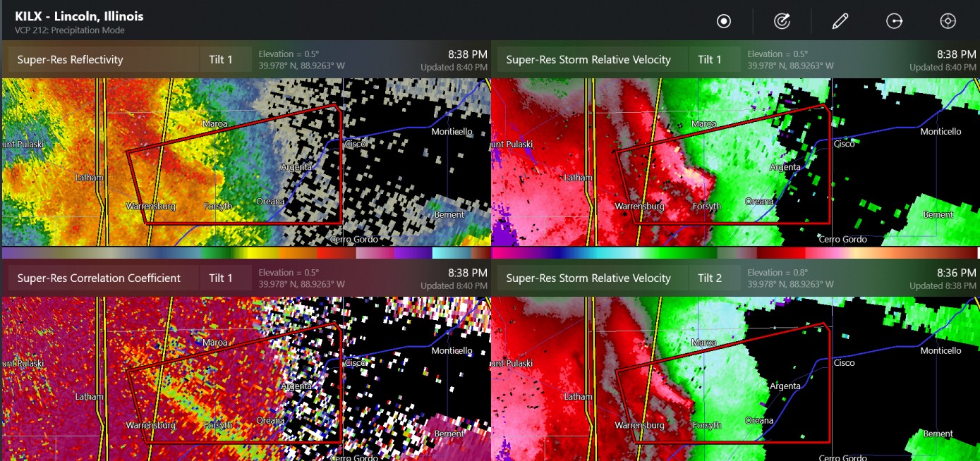
At least 1 tor confirmed in central IL last night thus far
-
1
-
-
8 hours ago, rainsucks said:
I'm not even convinced yet that next week's will pan out as currently modeled by guidance. I'm not saying it won't, but the models continue to overdo the intensity of cold shots time and time again, so I'm a bit skeptical.
Its nice to be back at the time of the year where a "cold" shot still leaves us in the upper 50's for highs.
-
3
-
-
9 minutes ago, Chinook said:
possible tornado south of Lincoln Illinois
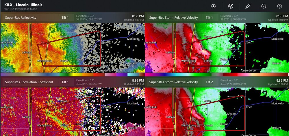
Rocking some pretty solid wind gusts in that area as well
-
Blanket tornado warning on that big line on S IL.
-
Planted a bunch of peas over the weekend, can use the rain and if we avoid the frost over the weekend that would be golden
-
Whole lot of “meh” so far
-
1 hour ago, A-L-E-K said:
another brief cool down before real sustained warmth?
This cool down appears to be moderating as we get closer as well.
Getting into the season where full sun will push you to overperform by 2-3 degrees.
-
4
-
-
Extended looks to be seasonal or slightly above. No significant cold to speak of, green up will be off to the races.
-
9
-
-
Snow globing, but melting on contact now.
-
1
-
-
Things seem to be “meh” across Illinois so far this evening
-
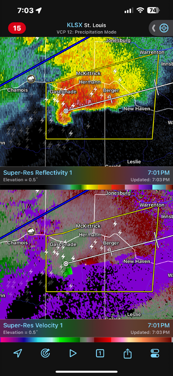
Another storm west of STL looking nasty too
-
9" report coming out of Rockford within the band
-
6
-
-
46 minutes ago, Geoboy645 said:


You could say that yeah. So much for those futility records lol.
You guys can keep it. Once we get that first hit of spring my "snow weenie switch" turns off.
-
1
-
 2
2
-
-
Reports of some big hail NW of STL
-
PDS warning, then the new one upstream is “radar indicated rotation”. They can probably update that, it is for sure producing
-
2
-


May 2024 General Discussion
in Lakes/Ohio Valley
Posted
Yeah, with the way the extended looks, I am planning on rolling out the garden a couple weeks early.