

Stebo
-
Posts
33,924 -
Joined
-
Last visited
Content Type
Profiles
Blogs
Forums
American Weather
Media Demo
Store
Gallery
Posts posted by Stebo
-
-
unbelieveable footage
Very fast motion too not to mention the individual vortices
-
Impressive looking tornado on the ground to the North of Birmingham. Multiple Vortex, with powerflashes.
-
I would think the southern area (TN, AL, MS) is pretty much a High Risk slamdunk.
No I would agree, I was just stating if there was anything that would cause them not to go High, it would be that. I personally would go high for S. KY south into MS/AL.
-
There continue to be some very critical differences between the NAM and GFS for tomorrow. Should be an interesting day to see how things evolve.
It's these differences that will probably cause them to not pull the trigger on a high until the 2nd outlook at 1300Z if they dont at 0600Z
-
classic wxmann trolling
indeed

-
A few honest points, as I do respect your opinion quite a bit.
I don't think you can say that yesterday and today underperformed (unless you were expecting a lot more). Yesterday ended up being a pretty decent outbreak with quite a few tornado reports, and today as well. The weakness of today's event (the weaker low-level wind field) was highlighted indirectly earlier, when it was stated that the timing of the trough was a bit slow, resulting in a weaker low-level response. Regardless, I am not a fan at all of the philosophy "the first day ended up underperforming, therefore the second day is more likely to underperform as well". Personally, I tend to treat every day as an independent event, because that's what they really are for the most part w.r.t severe weather. New geographic area, new instability/shear parameters, new storm mode questions, new morning precip issues, etc.
I don't think we'll have a problem of too many storms interfering with each other tomorrow. Unlike today, there is a clear focus for convective initiation, and given that the deep-layer shear vectors are perpendicular to the boundary (think April 15-16), it will ensure a sustained discrete supercell mode. There are questions regarding the extent of morning convection and its impact on the warm sector instability, but even the latest NAM run as Tony said is destablizing things very quickly following the passage of the first cluster. If there isn't a major tornado outbreak tomorrow, the morning convection is most likely going to be responsible.
Given the extreme rarity of seeing a strong mid-level 100 kt jet streak punching through a moist, unstable warm sector, with cyclogenesis ramping up the low-level wind fields and skyrocketing the helicities...the strong language used by me and many other mets regarding this event has been and is 100% justified. I try my best not to hype things up, and I'm brutally honest when I say I don't like a particular setup for reasons x,y,z. On the other hand, I know potential when I see it, and I have to be honest when I say that this might be the best outbreak setup I've seen in the dozen or so years I've been following severe weather. Whether it actually verifies that way or not, we'll just have to see...
Yeah I would have to agree with all of this, I think saying tomorrow will underperform is a bit premature. If we have issues with the setup by say noon tomorrow then we can talk about the potential underperforming.
-
people that throw out those comments should just be banned right off the bat.
Yeah I agree, I think we need to keep this thread to serious discussion as a good amount of the country is going to be affected tomorrow.
-
Where are all these people coming from?

Just like a blizzard or a major hurricane...
-
Hopefully you can join us in tropical season, when every tropical storm north of the islands with be comparable to Andrew.
 and anything in the gulf will be Katrina.
 -
That is yet to be seen...Isn't it foolish for you to write it off the day before?? It is very unlikely but it is my position that I still hold
I'm not writing off anything, I just think that you don't realize just how epic 30 F4 and 6 F5 tornadoes are.
-
The odds of this being another 'super outbreak' with 30 F4s and 6 F5s is about 1 in 1 million. Sure there will be a great number of tornadoes tomorrow, but to even put this outbreak in the same breath as the Super Outbreak is just foolish.
-
So they're ready to pull the HIGH risk trigger, just destab. uncertainties from convection expected to push through here overnight. Some of the worst outbreaks for Mid. TN have had convection move through overnight into the early morning, get a break, and then BOOM.
It is going to be a long 36 hours for the Nashville area, to say the least.
Yeah Tennessee is going to have a long day today and tomorrow, and its already been a busy time in the past 36 hours.
-
With the NAM and GFS looking so intense, I'm starting to wonder if we have enough to warrant a possible Day 2 High risk. I know the outlooks are trivial and the only things that matter are the reports, but it would still be interesting to see. Any thoughts?
We would be around the same area as it occurred last time way back in 2006:
There is certainly a potential of a High, of all 3 days Wednesday would be the one that has the highest potential get the High Risk designation.
-
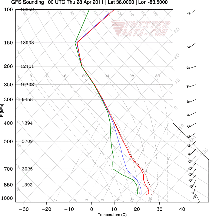
Pretty sick forecast soundings coming out of far southeast Oklahoma/northeast Texas tomorrow evening. This event won't be as widespread as what will happen Wednesday, but some strong tornadoes look quite possible over some of the same areas that were impacted today.
00z NAM forecast sounding over far southeast Oklahoma tomorrow evening...


Wow not often do you see such amazing shear coinciding with large instability like this.
-
GFS just bombed this run with the northern stream upper low displaced farther W allowing for more growth of the secondary main impulse Wednesday. Main result is even stronger mid level mass response and a slightly larger occlusion/dry slot, as expected. The hodos are almost unrealistic.
Yeah Wednesday is starting to get that scary potential to it. Especially with the models uniformly trending left each run.
-
I'd certainly argue there is a growing potential further North on Wednesday per the latest model runs, SREF showing higher numbers much further North than previous runs too.

-
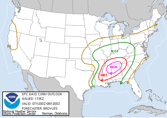
Wow, has a MDT on Day 1, 2, AND 3 ever happened before?
I'm guessing no.
-
Day 3 Mod too

DAY 3 CONVECTIVE OUTLOOK
NWS STORM PREDICTION CENTER NORMAN OK
0230 AM CDT MON APR 25 2011
VALID 271200Z - 281200Z
...THERE IS A MDT RISK OF SVR TSTMS ACROSS PARTS OF CENTRAL AND
EASTERN KENTUCKY...MIDDLE AND EASTERN TENNESSEE...NORTHEAST
MISSISSIPPI...CENTRAL AND NORTHERN ALABAMA...AND NORTHWEST
GEORGIA...
...THERE IS A SLGT RISK OF SVR TSTMS ACROSS A LARGE PORTION OF THE
ERN U.S. FROM THE LOWER AND MID MS/OH VALLEYS EWD...
...SYNOPSIS...
A LARGE UPPER TROUGH WILL CONTINUE SHIFTING EWD ACROSS THE U.S. THIS
PERIOD...WITH A POTENT SHORT-WAVE TROUGH/SPEED MAX SHIFTING EWD INTO
THE MID SOUTH REGION INTO THE AFTERNOON. AS THIS OCCURS...SECONDARY
SURFACE LOW DEVELOPMENT IS EXPECTED ALONG THE COLD FRONT S OF THE
MAIN GREAT LAKES REGION LOW. THIS SYNOPTIC-SCALE SETUP FAVORS
SIGNIFICANT SEVERE WEATHER POTENTIAL E OF THE MS VALLEY.
...PA/NW SSWWD TO THE GULF COAST...
YET ANOTHER DAY OF POTENTIALLY VERY SIGNIFICANT SEVERE WEATHER IS
EXPECTED DAY 3 /WED. AND EARLY THU. APR. 27 AND 28/ -- WITH ELEVATED
THREAT FOR A TORNADO OUTBREAK EVIDENT ACROSS THE MID SOUTH AND INTO
PORTIONS OF THE CENTRAL GULF COAST STATES.
STRONG/SEVERE STORMS SHOULD BE ONGOING AT THE START OF THE PERIOD
ACROSS THE NWRN PORTIONS OF THE SLIGHT RISK AREA...AS THE POTENT
SHORT-WAVE TROUGH AND ASSOCIATED MID-/UPPER-LEVEL SPEED MAX ROUNDS
THE BASE OF THE LARGER-SCALE TROUGH. WHILE AN INITIAL SURFACE LOW
SHOULD SHIFT NNEWD ACROSS THE OH VALLEY/MIDWEST...SECONDARY SURFACE
LOW DEVELOPMENT IS FORECAST DURING THE AFTERNOON IN THE KY/TN
VICINITY...WITH LOCALLY-BACKED SURFACE FLOW VEERING/INCREASING
SUBSTANTIALLY WITH HEIGHT RESULTING IN SHEAR PROFILES VERY
SUPPORTIVE OF SUPERCELLS AND TORNADOES. THE MOST FAVORABLE
COMBINATION OF RICH LOW-LEVEL MOISTURE...STRONG SHEAR...FOCUSED
LARGE-SCALE ASCENT...AND ANTICIPATED LACK OF APPRECIABLE PRIOR
CONVECTION INDICATES A RELATIVELY HIGH-CONFIDENCE AREA OF
CONCENTRATED SIGNIFICANT THREAT FOR POTENTIALLY STRONG TORNADOES AND
WIDESPREAD WIND DAMAGE CENTERED OVER THE MID SOUTH/TN VALLEY REGION.
THEREFORE...WILL INTRODUCE MODERATE RISK FORECAST ATTM --
INDICATIVE OF OUTBREAK POTENTIAL.
ALONG WITH FAIRLY SUBSTANTIAL SEVERE POTENTIAL EXTENDING FARTHER
NNEWD INTO PA/NY -- INCLUDING THREATS FOR DAMAGING WINDS AND
ISOLATED TORNADOES...SEVERE STORMS WILL LIKELY ALSO EXTEND E OF THE
APPALACHIANS INTO THE ATLANTIC COAST STATES. ALONG WITH THE
LIKELIHOOD FOR AFTERNOON SEVERE CONVECTION...SEVERE CONVECTION MAY
CONTINUE INTO THE OVERNIGHT HOURS AS THE SURFACE FRONT CRESTS THE
APPALACHIANS.
..GOSS.. 04/25/2011
-
Yeah I was guessing that was where thewxmann pulled the crazy soundings. I saw those too earlier--interesting to see if/how that feature develops.
Yeah, if it were to develop you'd have a severe backing of the winds at the surface, and the potential of significant tornado action would skyrocket.
-
It is propagating along the warm front--you can see it in the theta-e fields. It is definitely feeding off the moist inflow. It is definitely convective in nature--no other way to explain 90 kt 850 wind fields. Oddly enough Euro, CMC, UK all suggest this type of feature.
Oh you are talking about that NAM meso low that formed? Yeah that definitely had a convectively induced look to it, although it is interesting that the other models all show it. Might be something to monitor the potential of as we move through next few days.
-
lol... off the charts anyone?


Amazing shear, but not a terribly high amount of instability in the sounding.
-
I don't have a lot of time to type, but man is this going to be a long 3-4 day stretch. Gotta feel for MEG, LZK, TSA, etc.
Yeah what I would pay to have Tuesday off so I could leave for Memphis after work today for 3 days.
-
Day 2 Moderate risk
DAY 2 CONVECTIVE OUTLOOK
NWS STORM PREDICTION CENTER NORMAN OK
0100 AM CDT MON APR 25 2011
VALID 261200Z - 271200Z
...THERE IS A MDT RISK OF SVR TSTMS ACROSS FAR NORTHEAST
TEXAS...SOUTHERN AND EASTERN ARKANSAS...WESTERN
TENNESSEE...NORTHWEST MISSISSIPPI...AND NORTHERN LOUISIANA...
...THERE IS A SLGT RISK OF SVR TSTMS ACROSS A LARGER PORTION OF THE
EASTERN U.S. FROM THE NORTHEAST/E COAST STATES TO THE LOWER MS
VALLEY/SRN PLAINS...
...SYNOPSIS...
VERY LARGE UPPER TROUGH WILL REMAIN IN PLACE OVER THE CENTRAL
CONUS...AS ONE SHORTER-WAVELENGTH FEATURE SHIFTS INTO THE GREAT
LAKES AND A SECOND DIGS SEWD OUT OF THE ROCKIES. A SURFACE
BAROCLINIC ZONE IS EXPECTED TO EXTEND FROM THE GREAT LAKES/OH VALLEY
SWWD INTO N TX...AND WILL SERVE AS A FOCUS FOR WIDESPREAD SEVERE
CONVECTION -- INCLUDING THE POSSIBILITY OF A LOCAL SEVERE WEATHER
OUTBREAK FOCUSED FROM THE ARKLATEX REGION INTO THE MID MS VALLEY
REGION.
...ARKLATEX REGION ENEWD INTO THE LOWER/MID MS VALLEY...
COMPLEX -- BUT POTENTIALLY SIGNIFICANT/DANGEROUS -- SEVERE WEATHER
EVENT IS UNFOLDING FOR THIS AREA FOR DAY 2 /TUE. AND EARLY WED./.
STORMS WILL LIKELY BE ONGOING AT THE START OF THE PERIOD...SHIFTING
EWD/ENEWD INTO THE OH/TN VALLEYS ALONG WITH ONGOING SEVERE
POTENTIAL.
GREATER SEVERE THREAT FOR THIS REGION HOWEVER WILL EVOLVE LATER IN
THE DAY...AS AN INITIAL SHORT-WAVE TROUGH DEPARTING NEWD IS FOLLOWED
BY A SECOND/DIGGING FEATURE SHIFTING QUICKLY SEWD OUT OF THE ROCKIES
AND INTO THE SRN PLAINS.
AS THIS OCCURS...BACKING/INTENSIFYING LOW-LEVEL FLOW FIELD IS
FORECAST...WITH A 70-PLUS KT LOW-LEVEL JET TO SHIFT EWD FROM NE TX
ACROSS AR/LA DURING THE EVENING...BENEATH MID-LEVEL WLYS INCREASING
TO 70 TO 80 KT.
AS THE UPPER SYSTEM APPROACHES...SURFACE CYCLOGENESIS WILL OCCUR
ALONG THE WARM FRONT...SHIFTING EWD ACROSS N TX AND AR TOWARD THE
MID MS VALLEY LATE. STORMS SHOULD INITIATE DURING THE AFTERNOON
ACROSS NE TX AND QUICKLY BECOME SUPERCELLULAR...WITH LARGE
HAIL...DAMAGING WINDS...AND TORNADOES EXPECTED. A SUBSTANTIAL
TORNADO THREAT APPEARS LIKELY TO EVOLVE -- SPREADING ACROSS NRN
LA/AR AND THEN INTO WRN TN/NWRN MS LATE. ALONG WITH TORNADO
POTENTIAL...DAMAGING WIND/LARGE HAIL THREAT WILL ALSO ACCOMPANY THE
STORMS THROUGH THE END OF THE PERIOD -- POSSIBLY EXTENDING AS FAR E
AS MIDDLE TN/NRN AR/NWRN GA BY 27/12Z.
...LOWER GREAT LAKES REGION/OH AND TN VALLEYS...
THUNDERSTORMS ONGOING AT THE START OF THE PERIOD WILL CONTINUE
SHIFTING NEWD ACROSS THE TN/OH VALLEYS AND INTO THE LOWER GREAT
LAKES REGION. THIS WILL OCCUR AS STRONG SHORT-WAVE TROUGH SHIFTS
ACROSS THIS AREA FOCUSING LARGE-SCALE UVV ALONG A SURFACE COLD FRONT
EXTENDING SWWD ACROSS THE MID MS VALLEY INTO TX. WHILE AFTERNOON
HEATING MAY BE HINDERED BY WIDESPREAD PRECIPITATION/CLOUD
COVER...LOCAL AREAS OF GREATER DESTABILIZATION WILL SUPPORT
AFTERNOON INCREASE IN STORM COVERAGE AND INTENSITY -- AS FAR NE AS
PA AND NY NEAR THE SURFACE WARM FRONT.
WITH A STRONG SWLY FLOW FIELD ALOFT ACROSS THIS ENTIRE AREA
/LOW-LEVEL FLOW INCREASING FROM 50 TO 65 KT IN THE 850 TO 500 MB
LAYER/...SHEAR WILL SUPPORT ORGANIZED/ROTATING STORMS...ALONG WITH
LINEAR/BOWING SEGMENTS. ALONG WITH SOME THREAT FOR HAIL...DAMAGING
WINDS WILL BE LIKELY ALONG WITH THE POTENTIAL FOR ISOLATED
TORNADOES. THE THREAT SHOULD SPREAD EWD WITH TIME AS THE FRONT
SLOWLY ADVANCES...WITH SOME THREAT LIKELY LINGERING INTO THE
OVERNIGHT HOURS INTO NY/PA/WV.
...CAROLINAS/VA...
WEAK SHORT-WAVE FEATURES SHIFTING NEWD ACROSS THIS REGION --
EMBEDDED WITHIN CYCLONIC FLOW FIELD AHEAD ON THE ERN FRINGE OF THE
LARGE CENTRAL U.S. TROUGH -- WILL SUPPORT A BROAD ZONE OF AFTERNOON
THUNDERSTORM DEVELOPMENT ACROSS THIS AREA. WITH HEATING OF THE
MOIST BOUNDARY LAYER AIRMASS OCCURING THROUGH THE DAY...INSTABILITY
WILL BECOME SUFFICIENT -- IN CONJUNCTION WITH MODERATE/VEERING FLOW
WITH HEIGHT -- TO SUPPORT ORGANIZED/LOCALLY SEVERE
STORMS...INCLUDING THREATS FOR HAIL AND DAMAGING WINDS...AND AN
ISOLATED TORNADO. WITHOUT A CLEAR LOW-LEVEL FOCUSING
MECHANISM...WITH MAINTAIN ONLY 15%/SLIGHT RISK FORECAST ATTM --
GIVEN THE BROAD/UNFOCUSED THREAT AREA.
-
At glance the NAM is taking the low over or to our west
GFS is way southeast of us
That is as far as I have gotten lol

Yeah Beau right now the GFS is on its own with the further SE track, all the rest are to the West of it.
Historic Tornado Outbreak April 27, 2011
in Weather Forecasting and Discussion
Posted
Just an unbelievable image.