

Stebo
-
Posts
33,920 -
Joined
-
Last visited
Content Type
Profiles
Blogs
Forums
American Weather
Media Demo
Store
Gallery
Posts posted by Stebo
-
-
I'm amazed by the sheer complexity of the vortices in these videos...horizontal shooters, multiple satellites, giant parent mesos, etc
Yeah, really puts into perspective not only the vertical shear that was in the atmosphere but the horizontal shear today.
-
No kidding, he is lucky the periphery winds didn't flip his vehicle.
Yeah its tough to say how fast those winds were but I'd probably take a stab at 80-100+
-
I don;'t know whether those winds were inflow or RFD, but the 5 min mark is intense for being outside of the vortex
At first it was inflow from 4 to 6, around 7 mins its RFD when he moves the car.
-
Unreal footage from University Mall in Tuscaloosa.
3:00 min in is where the action starts really cranking.
Way too close there. That guy should have never been that close.
-
Did Spann just make reference to the Super Outbreak?
For the state of Alabama, which purely by the numbers could be comparable for the state of Alabama.
-
Yes, but I don't think you understand how some of this stuff is out of each individual's control. Imagine houses that don't have basements and are swept off their foundations. You're telling me if the people in those houses don't survive it's their fault b/c they didn't heed the warnings?
No I do understand that aspect trust me on that.
-
Fact of the matter is too many people have already died today. There is a reason we work everyday towards improving both the warning process and the responses they generate.
Agree, like many have said, you can put warnings out an hour in advance, but it is entirely up to the people to heed these warnings.
-
All...GA radio has the Catoosa Hotel being on exit 348, which is Ringold, which is populated. Google Maps tells us this is a Super 8, Holiday Inn Express or the Baymont Inn and Suites...
Restaurants were also mentioned with the term 'leveled.'
Praying.
Yeah this isn't like Bill's Motel. We are talking about big buildings.
-
Although the death toll will undoubtedly rise, I find the report of "hundreds of casualties" really hard to believe. I mean, we haven't had a 100+ fatality tornado in decades, and that was during the pre-tornado siren days.
The thing is, with what had happened this morning, most areas didn't have sirens today. This was the absolutely the worst possible scenario with respect to loss of sirens.
-
WAAO radio in Andalusia AL is reporting
Boy I hope this is high, because if not that is horrendous.
-
@twcMarkElliot: Catoosa Co GA is requesting mass casualty trailer be sent to the area.Tractor trailers knocked over on interstates. #gawx
This is not good at all, that area is kind of a radar hole too.
-
The Birmingham 0Z sounding is still juiced with some outrageous shear/helicity values.
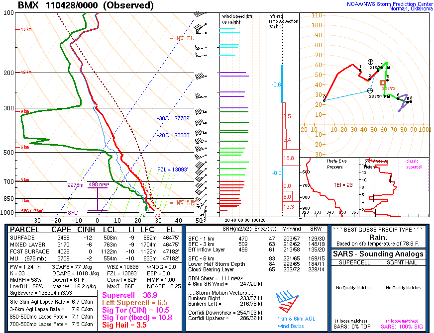
Yeah people often wonder what a supercell composite of over 30 and a sig tor over 10, we have seen what previous potentials can truly yield today.
-
Here's a shot of what used to be WAFF, Channel 48 in Huntsville's Doppler. It's now just a tower. Note the building in front of it.
From KAKE Meteorologist Jay Prater "I was the Managing Meteorologist at WAFF-48 in Huntsville, Alabama when "Doppler 2000" was installed along US-72, in the late 90s. My "pride and joy"...at that time, it was the most advanced privately owned weather radar in the state. Only the tower remains today after being struck by a tornado. Thank you WAFF-48 Chief Meteorologist Brad Travis for posting this image."
Man to pull off a radar ball like that is unreal.
-
The type of atmosphere today can be seen with the horizontal funnels rising up the outside of the tornado. Shear/helicity just incredible...
Yeah seeing that multiple times on different tornadoes in different parts of Alabama. Really unbelievable.
-
Tuscaloosa video....wowo http://vimeo.com/22970879
Only one word can describe that video, surreal.
-
I want to reiterate that the coverage out of ABC 33/40 today has been outstanding, and their message has probably saved many lives.
-
KBHM 272304Z 13010G21KT 1 1/4SM R06/5000VP6000FT +FC TSRA BR FEW037CB BKN046 OVC070 24/22 A2956 RMK TORNADO B02 TORNADO W-N MOV NE AO2 PRESFR OCNL LTGICCCCG ALQDS TS ALQDS P0021
-
The Highway camera image, is just jaw-dropping.
-
The whole meso just looks like its straight to the ground. Very dangerous.
-
This is going to stay very dangerous as it keeps going NE as there are a lot of towns between Tuscaloosa and Birmingham.
-
Unreal images from Tuscaloosa.
-
Man that skycam is extremely scary.
-
sw of Tuscaloosa i believe
Getting very dangerous, Tuscaloosa is a large city.
-
Btw I don't anyone actually mentioned this, but the PDS watch for Alabama, the probabilities are all >95%. I believe this is the first watch to ever have all >95%.
Historic Tornado Outbreak April 27, 2011
in Weather Forecasting and Discussion
Posted
I just got into work and all I can say is that I am speechless, and I fear that this number is still going to go up. Especially as they have just now seen the light of day down there.