

coastalplainsnowman
-
Posts
591 -
Joined
-
Last visited
Content Type
Profiles
Blogs
Forums
American Weather
Media Demo
Store
Gallery
Posts posted by coastalplainsnowman
-
-
On the coast, this far out, history says that if the R word is being uttered at all, that's big trouble. 5 days out we want to be debating coastal special vs. fish storm, not mix vs. snow.
While there have been a noteworthy few which trended the other way, even among those rare cases, the forecasts, for coastal folks, almost always trended from snow to nothing, not from 'wintry mix' to snow.
I'm gonna try my best to keep my expectations low on this one til Monday. Good luck to me with that.
-
I wonder how often LI has had more rainfall in inches than snowfall in inches in a given winter. Last year for sure.
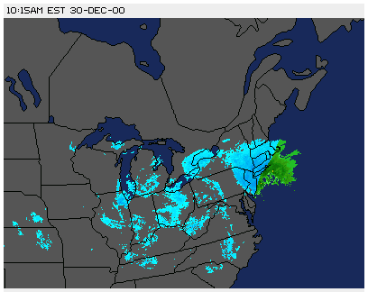
Just like with thunderstorms, the real wind action was before that line came thru, and that's accounting for radar lag. I always assumed that was typical given that it always seems to be the case, for me anyway.
-
 1
1
-
-
3 hours ago, Ralph Wiggum said:
At least the metros can keep their <1" snow days streak going.
This has the same vibe as me being ok with a Jets loss because we'll get a better draft pick.
Ah, to be a Jets fan and a snow fan living on Long Island in 2022/2023/2024. Great times..
-
1
-
 1
1
-
-
1 minute ago, SnowGoose69 said:
NYC has only 2 events where they record 1 inch of rain and then 5 inches or more of snow...12/25/02 is one. I cannot recall what the other is but Bastardi has posted it a few times, he uses it as an example that in general if you get significant rain the system better be undergoing a massive bombing or phase or it probably means significant snow after the changeover will be near impossible
Thanks - yeah I can only remember the one. NorthShoreWx who I would never doubt, responded "Pretty sure the south shore did that in February 2013. And late February 2010. May have happened in February 2015 too. Probably others." Maybe I overstated the case, and it's just that no 'memorable' snow has followed a moderate rain other than that 2002 one that I remember. Your 5" threshold would be a good definition of 'memorable.'
-
25 minutes ago, psv88 said:
Agreed.
Somebody will correct me if I'm wrong, but the only time in the past 40 years that LI has ever gone from at least moderate rain to snow that accumulated more than say, 3 inches, was on December 25, 2002 (which featured a lot more than that.) That's it, at least in the last 40 years in SE Nassau.
-
Looking like Jets/Patriots might take place during a snowstorm this Sunday up in Foxboro right? While the temperatures definitely wont be in the negative numbers, the combined offensive yardage might.
-
 1
1
-
-
Global temperatures have been rising for as long as we've been able to reliably measure it. The recent rate over the most recent 50 years is greater than the previous 100.
But the extrapolation by some on here of very, very recent events to suggest that we're witnessing a sudden point of no return right here before our eyes on americanwx.com, is unfounded and not scientific.
For the same reason that a cold snap or a blizzard doesn't dispute the fact that temperatures have been rising ("Weather is not climate", we are told), looking at a few recent years to suggest that it just won't snow any more in 'our new climate' (another term I see here a lot lately) is silly.
There's so much data to convince that things are getting warmer. Extrapolating very recent data to draw dramatic and ominous conclusions undermines such arguments. I don't see the mets or other experts on here who share their excellent posts about warming trends saying anything so dramatic - perhaps cues can be taken from them to - pardon the pun - chill out.
-
1
-
-
12 minutes ago, jm1220 said:
That was an amazing storm in Long Beach where I lived at the time. Absolutely dumping snow and thunder. And the rain snow line stayed east of me when it was expected to make it into the city. The low made a last second tick east which kept the city and W LI in it for 12”+. Went from that to all rain within maybe 20 miles. Same places made up for it though in the 3/5/01 storm that for the city was a disaster.
Exactly. Here's the screenshot I took at the time showing the rain/snow line sitting jusssssssst southeast of the Nassau/Suffolk south shore border. (When I tell people here to forget the radar and go enjoy the darn snow, I speak from experience lol.) To this day the heaviest/lowest visibility snow I have ever seen, going back to 1980.

-
1
-
-
Just now, Stormlover74 said:
Dec 96 to Dec 99 was probably the worst stretch before the surprise Jan 2000 storm.
100%. Remember too at the time that for coastal sections that saw little snow in the 93 superstorm, 93/94 and 95/96 seemed like freak anomalies against our experience in the 80s and early 90s.
Little did we know what the next 18 years would bring.
-
1
-
-
18 minutes ago, MJO812 said:
Winters have sucked once I changed my name to MJO. I need to change it back but I can't.
I guess when folks say 'correlation is not causation', this would be a good example lol
-
1
-
-
1 hour ago, nycwinter said:
such lovely weather it would have been a perfect day for opening day at yankee stadium...
1 hour ago, North and West said:
It’s warmer today than it will be for Opening Day (at Citi Field)
.I think this says as much about our current weather specifically at the moment as it does about early Spring weather around here. I realize, even spring has been deceptively above normal if I recall, but anecdotally, the theme seems to be the following:
a. Winter false start at Thanksgiving
b. Actual winter start delayed til early Jan
c. Damp winter remnants stubbornly hang around into April
Last year you could wear a ight minimally insulated water resistant jacket to work from January (because it was mild enough) through early June (because it was cool enough). Last year Jan - June was the uniseason.
-
3 hours ago, North and West said:
This rain has really perked up some new grass seed I put down for fall seeding along the curb and neighbor’s yard. Nice December 29th green lawn action.

.I see this too locally but I don't think I understand why. March and early April routinely see consistent temps much higher than the mostly mild conditions we've had recently, yet it takes a good while before actual grass (not weeds) start growing/greening up. Is it that some places never went 'dormant'? Not sure I know what I even mean by dormant, or if its driven strictly by temperature anyway.
-
1
-
-
6 hours ago, LibertyBell said:
Wow this is so peaceful and serene. Is this considered a lagoon?
Wikipedia says that the last time Mount Batur erupted was about the year 2000. Based on what I'm reading in this thread, sounds like the odds of it erupting again before we see measurable snowfall again at the coast are about 50/50.
-
1
-
 2
2
-
-
32 minutes ago, bluewave said:
NYC just experienced the 3 warmest consecutive winter months on record with all 3 months above 41.0°. This lead to the lowest calendar year snowfall at only 2.3”. This was warmer and less snowy than the Richmond, VA averages.
Jan 23…43.5°
Feb 23….41.1°
Dec 23...44.2°
AVG……42.9°
Dec 01…44.1°
Jan 02…39.9°
Feb 02….40.6°
AVG…….41.5°
Jan 98…40.0°
Feb 98….40.6°
Dec 98….43.1°
AVG………41.2°
Time Series Summary for NY CITY CENTRAL PARK, NY - Jan through Dec
Click column heading to sort ascending, click again to sort descending.RankYearTotal SnowfallMissing Count1 2023 2.3 6 2 1913 3.4 0 3 1973 5.6 0 4 1901 6.5 2 5 1998 7.5 0 6 1953 7.6 0 7 1931 8.0 0 8 1951 8.8 0 9 2012 9.6 0 10 1997 9.9 0
https://www.weather.gov/media/akq/climateRECORDS/RIC_Climate_Records.pdf
Richmond, VA….Jan…38.3°…Feb…41.0°….Dec…41.8°…snowfall….8.8”Thanks for this - just to clarify - warmer than Richmond was for the same time periods, or warmer than Richmond's likewise historical averages?
-
3 hours ago, bluewave said:
Action Park was my favorite place to go during the summers in the 1980s. NW NJ is a beautiful area. I wish you the best of luck when you make your move.
For what it’s worth, growing up on LI in the 80s with family up there, seemingly every time we had an agonizingly close snowstorm which was instead a cold rain storm, they would get plastered with snow, so often that it was the running joke.
-
1
-
-
2 hours ago, eduggs said:
I don't think there is a more misleading model chart than a 5 day averaged 500mb anomaly chart. If I had a dime for every time Brooklynwx posted one of those and said how good it looked, I'd buy twitter.
He posted one 440,000,000,000 times? Crazy if true.
I think that people who have a nostalgic love of snow and follow things on this board as hobbyists (present company included) are practically guaranteed to be unhappy if they set unrealistic expectations.
- If you love snow, and you're a met, that's great because it's great to be enthusiastic about what you do for a living, or aspire to do for a living.
- If you are someone who loves snow, but doesn't know about this board, then ignorance is bliss. If it's cold out, like it has been the last few days, you're loving it, not having much awareness about the fact that it will probably warm up and rain a little right on time for Christmas. You're living in the present and enjoying the evening. You're hopeful (and likely correct regardless of everything discussed here), that you'll get at least one or two grass-covering snows that will slow life down a bit this winter, and you look forward to it.
BUT, if you love snow, are not a met, and follow here to learn and to get the inside scoop, then you're rarely happy if you let yourself set your expectations too high. Sure, it's been crisp and cold the last few days, but we're bummed because we know it'll be warm soon. When it snows, we know with specificity when it's going to get washed or melted away, rather than being able to dream that winter wonderland will last for awhile. And while it is actually snowing, we watch the radar instead of the actual snow - the thing we waited for for months - aggravated that the very best bands aren't on top of us, and watching the western edge speeding eastbound from PA. Or, we watch the rain/snow line inching closer, and make sure we spoil the fun of those around you by letting them know.
-
1
-
-
2 hours ago, SACRUS said:
Records:
Highs:
EWR: 64 (1937)
NYC: 63 (1984)
LGA: 62 (2006)
Lows:
EWR: 13 (1953)
NYC: -1 (1919)
LGA: 16 (1953)Historical:
1957 - A tornado swept across Jackson County, Williamson County and Franklin County in southern Illinois killing eleven persons. (David Ludlum)
1981 - A heavy lake-effect snow blanketed the southern and southeast shores of Lake Michigan leaving up to 22 inches of snow at Valparaiso IND. (David Ludlum)
1983 - Record cold hit the north central states. At Havre, MT, the mercury plunged to a record reading of 34 degrees below zero. (Sandra and TI Richard Sanders - 1987)
1984 - A storm over southern California left up to 16 inches of snow in the mountains and upper deserts, with 13 inches reported at Lancaster. Edwards Air Force Base was closed, and Interstate 5 was closed from Castaic to the Tehachapis Mountains. (18th-19th) (The Weather Channel)
1986 - A strong winter storm, which developed off the coast of New Jersey and moved out to sea, lashed the northeastern U.S. with high winds, heavy rain, and heavy snow. The storm left snowfall amounts of up to 30 inches in Vermont, 24 inches in Massachusetts, and 20 inches in New Hampshire. The highest rainfall amounts approached four inches in southern New England, where winds gusted to 70 mph. (Storm Data)
1987 - A weakening storm moved into the Rocky Mountain Region producing six inches of snow at the Platoro Reservoir in the San Juan Mountains of Colorado. The storm then spread rain and drizzle across the Southern High Plains into the Middle Mississippi Valley, with thunderstorms over Texas. (Storm Data) (The National Weather Summary)
1988 - Warm weather prevailed in the central U.S. while cool weather prevailed across the eastern states. Sheridan, WY, with a record warm afternoon high of 68 degrees, was seven degrees warmer than Key West FL. (The National Weather Summary)
1989 - A winter storm moving out of the Great Plains Region spread freezing rain, sleet and snow across parts of the southeastern U.S. Freezing rain resulted in 170 auto accidents in the Memphis area during the evening hours. Unseasonably warm weather continued ahead of arctic cold front. Miami FL equalled their record for December with an afternoon high of 87 degrees. (Storm Data) (The National Weather Summary)
2009 - A monster snow storm affected the Mid-Atlantic and Northeast regions of the U.S. on December 18th through December 20th. The storm originated in the Gulf of Mexico and moved northward along the Eastern Seaboard, leaving behind heavy snow accumulations from North Carolina to Massachusetts. Impacts from this storm included the closing of major airports, interstate highways, and rail systems. Over 1,200 flights were cancelled at the three major airports in the New York City area, and hundreds of thousands of people lost power due to the storm. Seven people were reported killed across the Mid-Atlantic (source: Reuters). Over two feet of snow accumulation was reported in portions of North Carolina, Virginia, West Virginia, Maryland, New Jersey, and New York. At one point, the storm was over 500 miles in width, and affected 14 states and tens of millions of Americans (Source: AFP).
Thanks for these posts - these are great. I read them every time I'm on here, and kind of take them for granted, just like I do for a lot of the great stuff that you, Don, and others post daily. ( I'm sure I'm not the only one guilty of this.) Thanks for all the time you put into these.
-
8
-
-
2 minutes ago, vegan_edible said:
i think when i moved back here from california i killed winter. sorry guys :/
I guess I should do the same analysis now from whatever town you arrived from and see if there's been an opposite effect on temperature there.
-
1
-
-
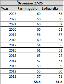
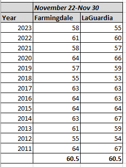
Right on schedule, our annual holiday mood crushing 60 degree day within a week of Christmas. Here's what I think happened: Somebody here sold their soul to you-know-who, Joe Namath style, in exchange for the December 26/27 2010 Blizzard, because since then, here's the high temperature reached at Farmingdale and LaGuardia, the week leading up to Christmas, for each year since. Based on the 13 years since, Farmingdale on average hits 58.6 degrees, and LaGuardia reaches 61.8. Edit: Did the same for Thanksgiving week, defined as Nov. 22-Nov 30th. Farmingdale for the Thanksgiving period averages just 2 degrees higher; LaGuardia has an outright lower maximum temp over the Thanksgiving timeframe than the Christmas week timeframe. (The averages are coincidentally the same for both sites for the Thanksgiving timeframe.)
-
2
-
1
-
-
16 minutes ago, Cfa said:
Getting some thunder now. It’s been a while.
If only you had put an 's' in that sad empty space between 'thunder' and 'now.' When I first read it, my mind tried so hard to imagine it there.
-
1
-
 1
1
-
-
1 hour ago, MJO812 said:
Feels like snow
The funny part is that reading about 2-4, 3-6, up to as much as 7, on December 17th, if I just stumbled in here I would be sure we were talking about snow totals.
Looks like we're going to be thisclose to getting our new obligatory, irritating, annual Christmas week 60 degree reading tomorrow.
-
There are some serious first world problems going on in here. What's so terrible? Replies we disagree with, feel aren't logically sound, or are written just to get a rise out of people? Or worst of all, God forbid, there's a tiny picture of a hotdog being applied to a post we like? Does it really need to be said that you can ignore posters you find irritating anytime you like? And just don't look at the emojis if that's too rough.
I blame the lack of snow on all of this, dammit.
Contrast with when a big storm, predicted for days, is finally bearing down on the area. That's when this place is awesome, when the whole 'I love you man!' vibe pervades. You know, when you get people saying stuff like 'I'm getting shut out, but you guys in location X enjoy it! I love you man!" It's the comical polar opposite of what we're seeing right now.
Just one real storm threat, that's all we need, like a Christmas miracle.
-
1
-
1
-
-
19 minutes ago, Dark Star said:
The NYC metro area has become too litigious. Seems (almost) nowhere allows skiing, skating, sledding...
Still holding on strong in Nassau. As a kid, Bethpage Park was awesome for sledding. Last time I was there about ten years ago it was still permitted, but restricted to certain roped off areas. Pleasantly surprising that it even still happens considering that the complex hosts majors and soon a Ryder Cup (last time I was there the sledding was between the Black and Green courses.) The backlash would probably be too much if they stopped it.
-
7 minutes ago, donsutherland1 said:
For reference, as the topic has arisen, below are the five December cases where measurable snow fell in New York City following a 60° or above high temperature:
December 15, 1881: 1.3" (prior day's high: 67°)
December 14, 1923: 1.2" (prior day's high: 64°)
December 9, 1956: 0.5" (prior day's high: 61°)
December 23, 1967: 1.2" (prior day's high: 62°)
December 16, 2008: 1.0" (prior day's high: 67°)
Overall, there have been 41 such cases in NYC's climate record (1869-present). January: 3; February: 5; March: 16; April: 4; October: 2; November: 6; December: 5
Biggest: 9.4", February 9, 2017 (prior day's high: 62°)
Such events are very uncommon. It's premature to reach any conclusions about next week other than noting that a few model solutions including the 0z ECMWF bring some measurable snow to the City.
Thanks as always Don.
While the general point being made here and elsewhere about the rarity of snowfall immediately following a 60 degree December day makes sense, I was struck in a different way by this data: I was surprised to see that there's such a population of 60 degree December days going back to the late 1880s that we actually have a subset of five such days followed by snow to even talk about. Prior to the crazy run of 60 degree days popping up in mid December for most of the past 12-15 years, I'd only remembered one such warm day in the 80s, and always assumed 60 degrees in December to be exceedingly rare prior to that point, but that doesn't seem to be the case.
-
1
-
Potential extensive winter event, I-95 west and with again a chance for NYC first inch(es) of snow Mon or more likely Tue Jan 16, 2024 (serves as OBS thread as well)
in New York City Metro
Posted
Is that anything new? I know nothing about the inner workings of these models, but generally, aren’t models often driven by the same statistical formulas which drive AI? I always assumed that was the case. Maybe it’s a marketing thing, calling it AI now?