

coastalplainsnowman
-
Posts
591 -
Joined
-
Last visited
Content Type
Profiles
Blogs
Forums
American Weather
Media Demo
Store
Gallery
Posts posted by coastalplainsnowman
-
-
45 minutes ago, snowman19 said:
It’s just wait and see what happens after 2/15 at this point. The ensembles and weeklies are either going to verify or they’re not…..
I bet everything I own that this statement turns out to be true.
-
 2
2
-
-
Seems like a good time to ask: how much for Philly?
(I wonder how many will get this reference lol)
-
4
-
 1
1
-
 3
3
-
-
10 hours ago, NorthShoreWx said:
The January 19-20 (17") snowstorm in 1978 was a surprise. The overnight forecast was for an inch or two of snow changing to rain and we woke up the next morning to a raging blizzard. The February 6 blizzard was talked about days in advance. I remember that I brought a portable radio to my indoor track meet on Saturday (2 days before the storm) so that I could get forecast updates during the day. Like most here, I've been at this since I was a kid.
That story about the radio is awesome! In the rare times snow was in the forecast, working evenings at the mall as a kid I'd time my short break so I could head over to the electronics department in Macy's or JCPenney's and catch the weather guy on WPIX, who I knew would be on at 7:45. Sorry, banter I know, couldn't help it.
-
4
-
-
7 hours ago, NorthShoreWx said:
The forecast 24 hours before the blizzard of '78 was for a foot or more. It was an LFM success
Thanks - I qualified my timeframe for the 12" forecast point to 1980-1993 because of 1978 - as I recall anecdotally that one caught LI by surprise to some degree too tho right? I just remember from what my father said after coming home after being snowbound in NYC. Were some models were calling for it but the forecasts on TV/radio were lower than that? For 1980-1993 do I have that right?
-
1
-
-
9 hours ago, Tatamy said:
I grew up in the 70s on LI. The concept of a 6”+ storm basically did not exist at that time. The greatest amounts that were ever forecasted were 4-8” by AW because that was as big a storm as there could be or so it seemed. We had two storms of about 7” during that period and that was it.
Amen. The total number of snowfalls greater than 10 inches between the early 70s and 1995 here was well under 10 total. As you say, a 3-6 forecast was a big deal. 6-12 was downright giddiness to a kid, and other than 1993 I don't think I ever saw a 12+" forecast map between 1980 and 1993. The Blizzard of '83 of course ended up well over that, but I don't think the forecasts ever caught up, and 1993 did have such maps, but that turned to rain too soon for most of LI. Contrast with the 2000-2018 period where over 2/3rd of the years had a 10" storm.
-
2
-
-
6 minutes ago, LibertyBell said:
The K-T event cannot be minimized, the earth was completely cut off from sunlight for 6 months-- it killed 75% of all life on the planet. And we whine after a few days without sunlight, can you imagine 6 months of total darkness all over the planet? Yes, the Permian event killed more, 90%-- but they are ranked #1 and #2 in the six mass extinction events this planet has faced. Humanity has created the sixth all on its own.
The Great Dying, mass extinction, asteroids. Man do we need a storm to track, and fast.
(edit: he says respectfully and in good fun)
-
2
-
1
-
-
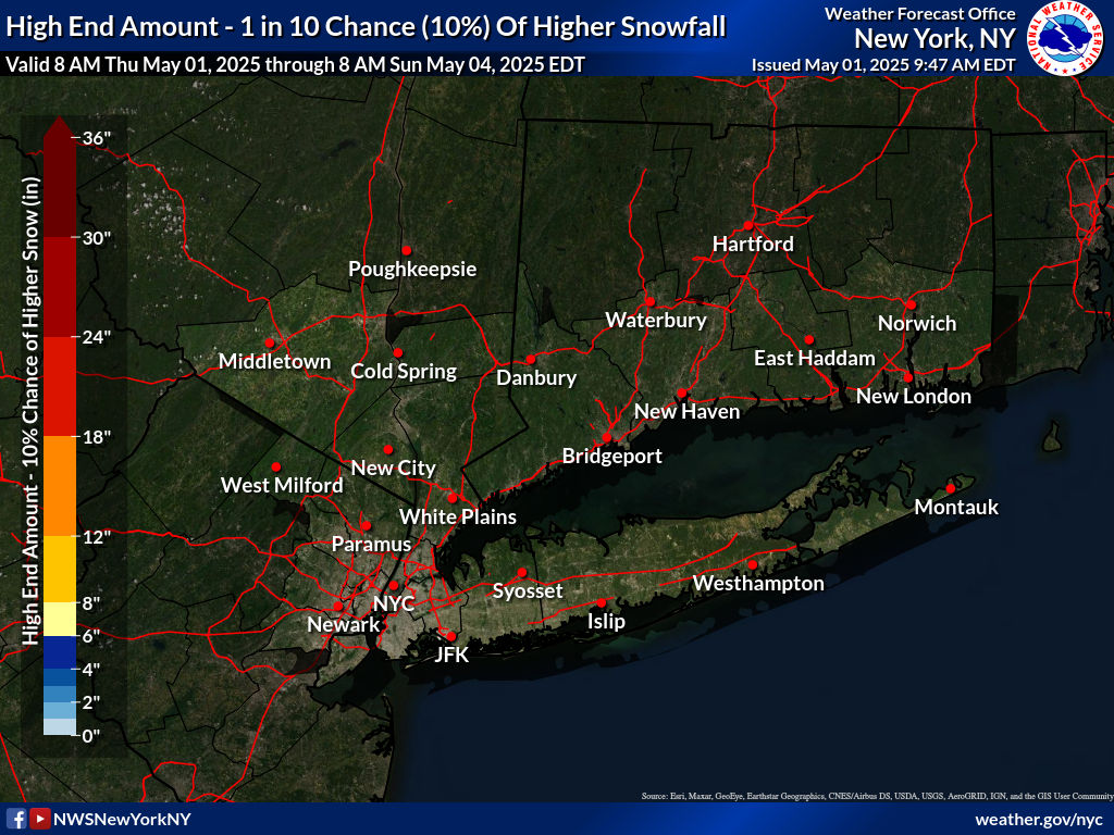
25 minutes ago, uofmiami said:
That was the high end forecast. This is what to expect:
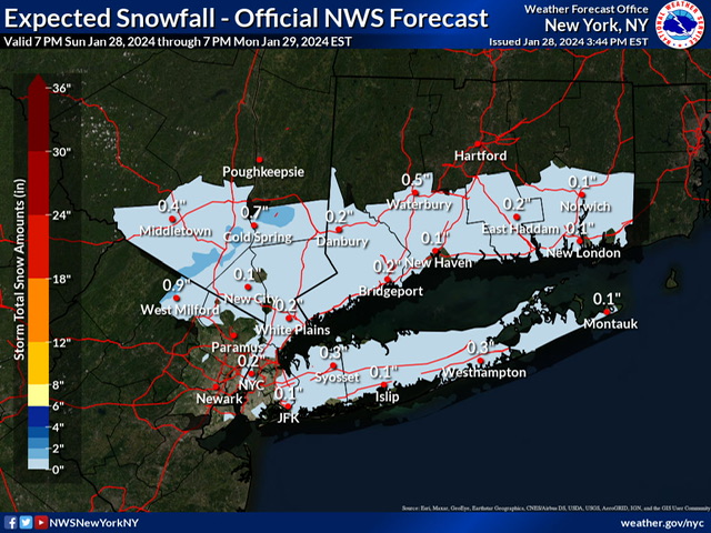
If I gave the impression that I'm hanging my hat on, or am enthusiastic about, a 10% chance 0.5" snow forecast, allow me to clarify that I am not.
")
Honestly just thought that the map was interesting.
-
2
-
-
1 hour ago, NorthShoreWx said:
NEAR TERM /THROUGH MONDAY/... Mid-level dry across the area has resulted in mainly drizzle and/or light rain for the afternoon hours, but every now and then a heavier pocket may mix with sleet and/or snow as verified by mPING reports. The upper low/trough will move across the area and precipitation should fill back in with a moistening vertical profile. Expect the snow growth region (-10 to -20C) to moisten and rain to transition to snow through the night with even a rain/snow mix getting down to the coast during the early morning hours. However, temperatures are forecast to generally be above freezing through the night with the possible exception of higher elevations across inland areas. Precipitation will generally be light, so any accumulations should be minor. Liquid equivalent overnight into Monday will be about a 0.25". Also interesting to note, as surface low pressure passes to the south and east, gusty NE winds will become more northerly through the night. For Long Island, this will be off the Long Island Sound. Multiple high res models are picking on a west to east enhancement in the precipitation across Long Island. This is due to a moist upslope component which has been noted in past events. It doesn`t take much elevation to help squeeze out a bit more. This may be enough to provide a coating of snow across this area.
Interesting. Yeah that shading of slightly more snow right along the spine of the island w/less north and south - can't say I've ever seen a forecast map like that before.
-
18 minutes ago, MANDA said:
I think the Boston stat is sadder than CP.
I disagree. If I have $2.30 and my buddy in Boston has $7.90, it doesn't matter to me that he's supposed to have $19.30 - he still has more money than me. Sure, I can laugh at him about that, but he can still buy a #7 meal at McDonald's while all I can get is a Diet Coke.
-
2
-
1
-
-
2 hours ago, Volcanic Winter said:
Just looking at snowfall to date the strip of purple to blue at the immediate coast from Boston all the way to DC is pretty crazy. I hadn’t realized the Cape & CT coast are pretty much in the same position as the immediate NYC metro. Shows how the warmth is a problem all the way to Boston along the immediate coast, though them doing a touch better is of course expected.
Really hoping something works out in Feb.
I think part of that is just the fact that it is the coast, and just the way it goes sometimes around here. It also seems like this winter isn't so atrocious so far once you get away from the immediate coast. The talk here has been so doom and gloom generally (edit: among the amateur / snow fan crowd like myself), that looking at the totals posted above, I was actually surprised to see how many within this forum's 'viewing area' are near or well over a foot. Just asking aloud here, Is that map so far off from norms for January 21st, again, just away from the coast? Even right at the coast, what's normal for this point in the season? Can't be more than 6-8" at best.
-
1
-
-
1 hour ago, LibertyBell said:
funny how the south shore of long island does poorly even when further south does better lol
More irritating about the weather here is how many nice Spring days get ruined.
Can't count how many times I'd leave the office under a beautiful blue sky and high 60s, head down the Wantagh, seeing what looked like smoke in the distance, and be in damp and misty mid 50s by the time I was home.
Thinking back, afternoon baseball practice was always tough as a kid here.
The evenings from mid June to early August can be awesome though.
-
 1
1
-
-
Just now, FPizz said:
Light snow coming down like someone is sprinkling Locatelli cheese from the sky. 2.1"
Makes sense ‘cause this storm stinks.
-
1
-
-
4 minutes ago, kat5hurricane said:
The meltdowns over a storm that was never a big deal in the first place.
I was thinking too how 1-3" was basically a rounding error for many storms in recent years. I'd often log in here when a light to borderline moderate event was a possibility and it was a relative ghost town, because "2 to 4" had become the new "cloudy."
-
8 minutes ago, jm1220 said:
They'll likely back down north of I-195 with the overnight update.
It's hard to see how the Upton and Mt. Holly maps square, especially looking at the lollipop in Red Bank NJ vs what's forecast the south shore of LI. I realize its a tight gradient and the latitude difference isn't totally trivial, but still.
-
25 minutes ago, nycsnow said:
Ukie doesn’t even give nyc area an inch euro is barley over an inch
That much barley is bad for the digestive system.
-
1
-
1
-
-
1 hour ago, NorthShoreWx said:
Most of the winters in the first half of the 80s had at least 1 good month, mostly in January and the Januarys were cold so the snow stuck around for a bit. Here are snowfall stats from Syosset that include the early 80's. Note that even then March was running snowier than December:
https://www.northshorewx.com/ClimateData/SyossetSnowfall1974-1985.pdf
Thanks, this is great. And that's absolutely right about the snow sticking around. We've had storms during the great run since 2000 in which 15" fell in the dead of winter that were totally gone so quickly that it was almost not to be believed. Yet back then a 5 inch snowfall would mess up my Newsday delivery work for weeks.
It's not surprising but still noteworthy how Syosset's numbers look as compared to say at the other end of 135. Those numbers, especially from 80/81 - 84/85, average about 5" higher than what I usually see for LI. And you definitely know better than me that good as those numbers are, the sweet spot for LI a good 25 miles east of there are even better, right? The gradient between, say, Amityville and Stony Brook is significant.
-
2
-
-
5 minutes ago, weatherpruf said:
Had some blockbuster events though....the Jan 82 storm that brought the DC flight down into the Potomac, the April 82 blizzard, followed by the Feb 83 blockbuster....then nothing til Jan 87. That was it for the whole decade, really...
Whoever said earlier that at least in the 80s you could count on at least a few 4-6” events each year, I agree. In grade school we seemed to get precisely one snow day a year from them. Seemed like the very clippers that for the last two decades mean white rain around here were our go-to for a few 4-6 inchers a year back the . Everyone who was around back then remembers ‘Alberta Clipper’ right? That’s what almost all of them seemed to be.
-
4 minutes ago, Dark Star said:
Barron’s Earth Science NYS Regents guide vibes.
-
2
-
-
2 minutes ago, SBUWX23 said:
Jeez sorry I didn't know I wasn't letting people vent man.
I'm sorry man I was going for a laugh but it came off wrong
-
1
-
-
1 hour ago, SBUWX23 said:
You live near an ocean that has a warm stream running near and off the coast. You have been spoiled over the last 10-15 years with big storms and KUs. They don't always work that way. Both of these systems are not classics by any stretch and of course they'll have some challenges.
C'mon man, you've got to let folks vent a little lol. That post was small enough to be a classic 140 character tweet. Just because it snowed a lot in the past two decades doesn't mean he has to be happy with 1 inch of snow and ice. He knows he doesn't live in the Alps.
-
57 minutes ago, TriPol said:
Nickels and dimes add up to dollars. Never forget that.
lol true, but I'd rather win a million dollar lump sum lottery prize than a dollar a year for a million years, which is closer to our current rate.
-
2
-
-
1 hour ago, LibertyBell said:
It had some interesting microclimates. The western part of the south shore did a lot better, we had close to 50" that winter (JFK had 47 inches if I remember correctly.) There was that amazing ice storm in January which was historic with close to 2 inches of ice (it never got to freezing here in that storm), and in February we had those amazing back to back storms with thundersnow. 8 inches with the first storm and 11 inches with the second storm.
I was surprised at what LongBeach posted, so maybe what you say above explains it. I was just north of Sunrise and I remember driving into work hear Pat Pagano (who is still on the air btw, comfy as a winter fireplace) warning that temps were being very stubborn to get above freezing for that memorable storm. To my knowledge we never did get above freezing, or did so very late after being back home for the day. Granted, stumbling across wunderground almanac recently I realized that I've blocked out some of the albeit brief milder stretches of that winter, but still, from that locale, when I think of 93/94, I think snow, cold, ice, and sidestreets snowpacked for longer than I've seen before or since. I think of the best snow-on-snow I've ever seen, three days apart on a Tuesday and Friday in Feb, etc.
-
2
-
-
27 minutes ago, weatherpruf said:
I gotta disagree here. We know better now, and nothing is so important that it can't wait, except for medical and essential workers. School can wait, can be done online, can be made up. Yes we drove in the bad weather in the past. I got stuck in the heavy dump in Jan 87 that was not well modeled; I never saw snow come down like that. I drove a Chevy Monza, rear wheel drive on an 8th of a tank. I could have died. They let us out at 10 am from Piscataway. Took me 4 hours to get to Woodbridge. In Dec 92 I got stuck teaching a class all day with no power because they didn't think to cancel classes with a huge storm coming. And, we also have demonstrably worse weather now, witness the pics above in Metuchen. Nothing personal here, I just don't think the risks are worth it.
It's just a matter of judgement. Folks here aren't making the 'Hey our parents smoked in the car and we didn't wear seatbelts. I love the good old days, why can't it still be that way' argument - that's a dumb argument. I think folks are just saying that the judgement these days seems to err too hard on the side of caution. Additionally - and I know this point has been made at some point here - if there's genuine concern about safety, then close the schools, don't have the dopey 2 hour delay, which just causes problems for everyone involved.
-
3
-
-
21 minutes ago, White Gorilla said:
You know things are really desperate when you see MJO agree with Snowman.. Wow. I screen shot that for my records.
I just checked the temperature from the reporting station at Hell Airport (KHLL.) It's below freezing.
-
1
-
February 2024
in New York City Metro
Posted
I think they should positively charge the fan blades, and then outfit the birds with positively charged vests and helmets, causing the birds to be repelled away to safety.