tombo82685
-
Posts
13,428 -
Joined
-
Last visited
Content Type
Profiles
Blogs
Forums
American Weather
Media Demo
Store
Gallery
Everything posted by tombo82685
-
 that day 9/10 setup def favors the kbuf to kart zone again. Fits the phase 2 composite mjo in nina, gradient with se ridge
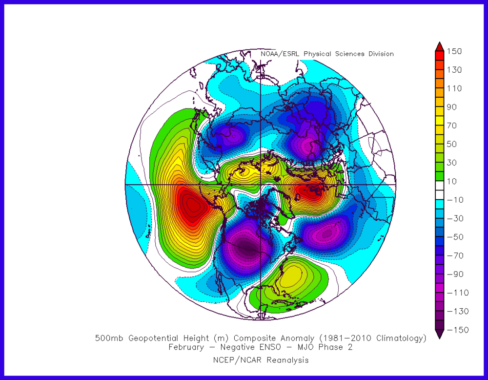
-
.3 of fluff out of that last burst.
-
Last february was driven by a SSW, completely different this year. We are basically hanging on favorable MJO right now which is giving us a bit favorable of a pacific look but with lack of blocking nothing can turn the corner unless the pna ridge is in the right spot.
-
some nice fatties falling right now, temp 30
-
you can hop on the tombo train if you want. Plenty of seats onboard
-
problem is, very little houses in that area. Basically would have to buy land then build
-
luckily I'm single, so it's wherever the bleep I want to go lol. I've been thinking that rodman to worth to copenhagen over to 81 south of watertown
-
im right where the E is in lowville
-
O yea, elev is massive. Honestly, I probably will move again to somewhere in the tughill in the near future. I got this house to just get up here. Now that I'm close I actually take the time to look at houses instead of driving 5 hours to see a house. Btw, pretty wild, lowville webcam in the center of the town is not even snowing really. Been steadily snowing here as I'm basically on the edge of the adirondacks.
-
yea I'm at 840, so relatively same in elev.
-
you guys warm pretty fast, been stuck at 28 here with some piddly flakes falling.
-
27 with some flurries falling
-
This should make Matt happy
-
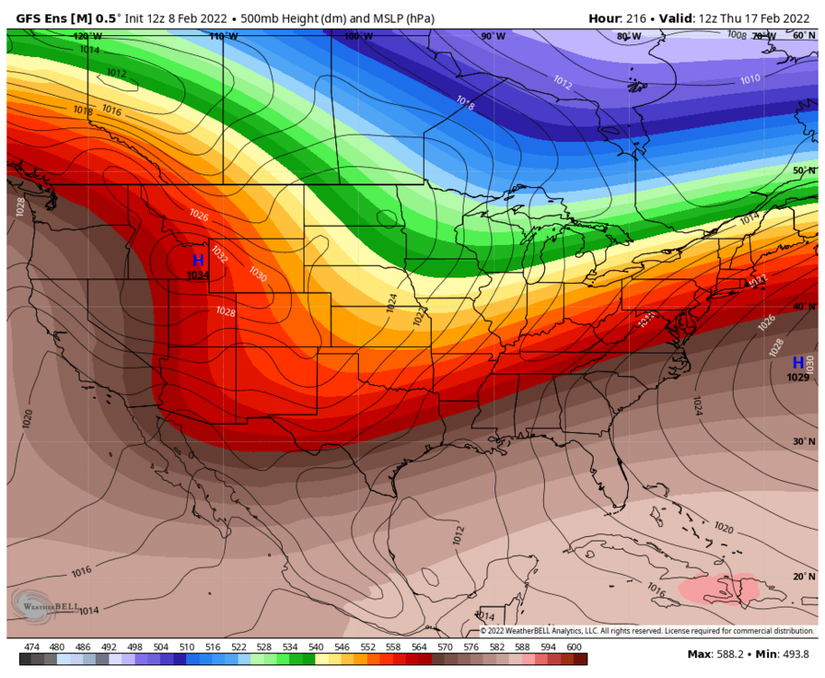
keep on adjusting euro, keep on adjusting
-
yea, coastal locations are doing well, but you go inland from there eeeek. Warm december followed by cold/dry january didn't help
-
the whole interior northeast is doing terrible honestly. Just hasn't been a good winter in terms of snowfall, but good for snow pack retention
-
this def explains why numbers are lower. Def not a fan of measurement 1 time a day, I do every 6 hours, then clear https://www.weather.gov/media/coop/Snow_Measurement_Guidelines-2014.pdf
-
whats funny, what the i95 crew is rooting for is killing us on Saturday. One point that was looking like a decent shot of snow. Now since the flow is more amplified and the trough axis is pushed further to our west, it's really increasing the southwest flow torching the low levels leading to mainly rain now. Granted, the low track was always to our north, so the southerly flow was always there. Now its just roided up. Maybe it can produce something now with that coastal. EPS kind of hinted at it
-
Yea I agree I don’t see any issues moving forward. Still think middle of next week can produce
-
That lowville number is way off from what I have. It’s kind of the same discrepancies I have with them as Wolfie has with Pulaski numbers. They have missed some snow events and or way to low with event. Not sure if it’s a measuring procedure or not. I’m at 53” per my chart
-
Well I figured that was implied since we all live, well most of us live in lake effect area. The clipper enhances the lake effect. I see your point though as clipper moisture is north of low track
-
Of course you Debbed on it when I mentioned it a few days ago now in line for 3-6
-
That’s right, I forgot they are bgm. South winds are everyone’s torch because it’s a warm wind. Some places just warm up more like cuse.
-
Only 35.0 so far back down to 34