donsutherland1
-
Posts
23,765 -
Joined
Content Type
Profiles
Blogs
Forums
American Weather
Media Demo
Store
Gallery
Everything posted by donsutherland1
-
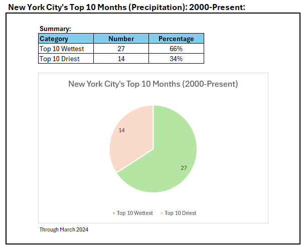
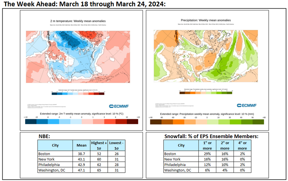
Much of the northern Mid-Atlantic region and parts of southern New England saw daily record rainfall today. Daily records through 6 pm included: Allentown: 1.73" (old record: 1.12", 2005) Atlantic City: 2.69" (old record: 1.59", 2005) Binghamton: 1.03" (old record: 0.74", 1968) Bridgeport: 3.28" (old record: 1.28", 2020) Hartford: 1.96" (old record: 1.14", 2020) Islip: 2.22" (old record: 1.32", 2020) New York City-Central Park: 3.66" (old record: 1.60", 1929) ***3rd highest daily rainfall in March*** New York City-JFK Airport: 3.13" (old record: 1.28", 2020) New York City-LaGuardia Airport: 3.47" (old record: 1.44", 2020) Newark: 2.97" (old record: 1.52", 1961) Philadelphia: 3.09" (old record: 1.36", 2005) Poughkeepsie: 2.05" (old record: 0.83", 1944) Trenton: 2.91" (old record: 1.62", 1961) White Plains: 3.00" (old record: 1.20", 2001) Wilmington, DE: 2.81" (old record: 2.05", 1903) Philadelphia's daily rainfall also set a new record for highest daily rainfall for any day in March. The previous record of 2.79" was set on March 15, 1912. As a result of today's rainfall, March 2024 now ranks among the 10 wettest Marches on record in New York City. In addition, 66% of the top 10 wettest months have occurred since 2000, even as the 2000s account for just 16% of months in New York City's climate record. Top 10 wettest and warmest months are both disproportionately represented by the 2000s. In the wake of today's storm, tomorrow will be blustery and unseasonably cold. Moderation will follow. The closing days of March could turn warmer. However, the kind of warmth that occurred earlier in March is unlikely. It is very likely that New York City's Central Park will finish the 2023-2024 snow season with less than 10" of seasonal snowfall for a record second consecutive season. Records go back to 1869. The ENSO Region 1+2 anomaly was +0.4°C and the Region 3.4 anomaly was +1.1°C for the week centered around March 13. For the past six weeks, the ENSO Region 1+2 anomaly has averaged +0.88°C and the ENSO Region 3.4 anomaly has averaged +1.42°C. The ongoing basinwide El Niño event is now fading. Neutral conditions could develop during the spring. The SOI was +3.68 today. The preliminary Arctic Oscillation (AO) was +0.097 today. Based on sensitivity analysis applied to the latest guidance, there is an implied near 100% probability that New York City will have a warmer than normal March (1991-2020 normal). March will likely finish with a mean temperature near 48.2° (5.5° above normal).
-
Central Park picked up 0.90” of rain in the past hour, which is a near record hourly amount for March. The March record is 1.20”, which was set on March 23, 1929. No other March day has received 1” or more hourly rainfall.
-
March 2024 has now moved into the top 10 wettest Marches on record. A disproportionate share of top 10 wettest months have occurred since 2000. The 2000-2024 period accounts for 16% of all months in NYC's climate record.
-
E PA/NJ/DE Spring 2024 OBS/Discussion
donsutherland1 replied to Hurricane Agnes's topic in Philadelphia Region
Philadelphia has now picked up 2.80" of rain today. That makes March 23, 2024 Philadelphia's wettest March day on record. The old record of 2.79 was set on March 15, 1912. March records go back to 1872. -
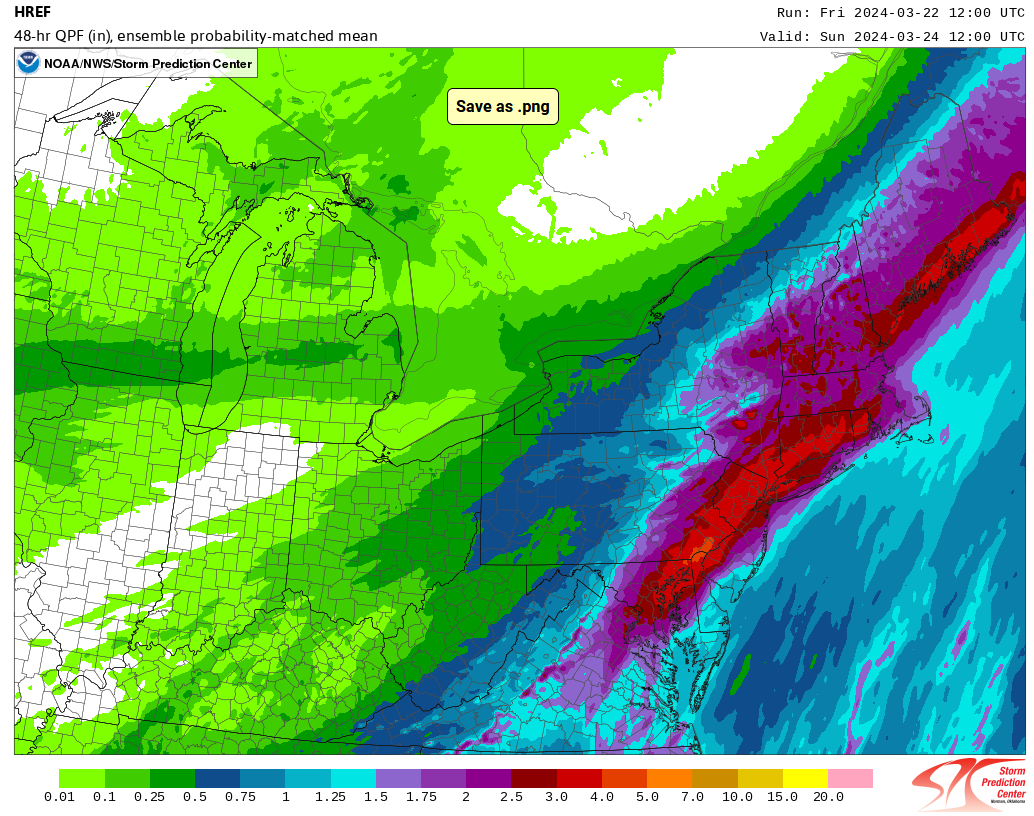
A significant rainstorm will drench the region tomorrow. Much of the region will set daily rainfall records for March 23rd, as a storm brings a windswept 2.00"-4.00" of rain with locally higher amounts to the region. Significant coastal flooding at high tide, along with beach erosion is likely. Following the rainstorm, March 2024 will rank among the 10 wettest Marches on record in New York City. In addition, 66% of the top 10 wettest months will have occurred since 2000, even as the 2000s account for just 16% of months in New York City's climate record. Top 10 wettest and warmest months are both disproportionately represented by the 2000s. Milder air will also begin to return during the weekend. The closing days of March could turn warmer. However, the kind of warmth that occurred earlier in March is unlikely. It is very likely that New York City's Central Park will finish the 2023-2024 snow season with less than 10" of seasonal snowfall for a record second consecutive season. Records go back to 1869. The ENSO Region 1+2 anomaly was +0.4°C and the Region 3.4 anomaly was +1.1°C for the week centered around March 13. For the past six weeks, the ENSO Region 1+2 anomaly has averaged +0.88°C and the ENSO Region 3.4 anomaly has averaged +1.42°C. The ongoing basinwide El Niño event is now fading. Neutral conditions could develop during the spring. The SOI was +7.18 today. The preliminary Arctic Oscillation (AO) was +0.698 today. Based on sensitivity analysis applied to the latest guidance, there is an implied near 100% probability that New York City will have a warmer than normal March (1991-2020 normal). March will likely finish with a mean temperature near 48.1° (5.4° above normal).
-
After a brisk day, another cold night lies ahead. The low temperature will again fall below freezing tomorrow morning in New York City. Readings in the 20s are very likely outside New York City, Newark, and Philadelphia. There is even a chance that the temperature could dip just below 30° in New York City. A storm will likely bring a windswept 1.50"-3.00" of rain with locally higher amounts during the weekend. Significant coastal flooding at high tide, along with beach erosion is likely. Milder air will also begin to return during the weekend. The closing days of March could turn warmer. However, the kind of warmth that occurred earlier in March is unlikely. It is very likely that New York City's Central Park will finish the 2023-2024 snow season with less than 10" of seasonal snowfall for a record second consecutive season. Records go back to 1869. The ENSO Region 1+2 anomaly was +0.4°C and the Region 3.4 anomaly was +1.1°C for the week centered around March 13. For the past six weeks, the ENSO Region 1+2 anomaly has averaged +0.88°C and the ENSO Region 3.4 anomaly has averaged +1.42°C. The ongoing basinwide El Niño event is now fading. Neutral conditions could develop during the spring. The SOI was +6.89 today. The preliminary Arctic Oscillation (AO) was +0.526 today. Based on sensitivity analysis applied to the latest guidance, there is an implied near 100% probability that New York City will have a warmer than normal March (1991-2020 normal). March will likely finish with a mean temperature near 48.0° (5.3° above normal).
-
Boston has never had two consecutive seasons with less than 20" of snow. The lowest two season average was 17.4" (1979-80 and 1980-81).
-
A strong cold front is crossing the region. Already, the temperatures is falling from New York City westward. The low temperature will likely approach or reach freezing tomorrow and Friday morning in New York City. Readings in the 20s are likely well outside New York City, Newark, and Philadelphia. A storm will likely bring a windswept 1.00"-3.00" of rain with locally higher amounts during the weekend. Significant coastal flooding at high tide and beach erosion are likely. Milder air will also begin to return during the weekend. The closing days of March could turn warm. It is very likely that New York City's Central Park will finish the 2023-2024 snow season with less than 10" of seasonal snowfall for a record second consecutive season. Records go back to 1869. The ENSO Region 1+2 anomaly was +0.4°C and the Region 3.4 anomaly was +1.1°C for the week centered around March 13. For the past six weeks, the ENSO Region 1+2 anomaly has averaged +0.88°C and the ENSO Region 3.4 anomaly has averaged +1.42°C. The ongoing basinwide El Niño event is now fading. Neutral conditions could develop during the spring. The SOI was +3.25 today. The preliminary Arctic Oscillation (AO) was -0.827 today. Based on sensitivity analysis applied to the latest guidance, there is an implied near 100% probability that New York City will have a warmer than normal March (1991-2020 normal). March will likely finish with a mean temperature near 48.0° (5.3° above normal).
-
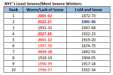
Seasonal snowfall and winter temperatures are normalized and both variables are weighted equally. 1995-96 saw seasonal snowfall that was around 3 sigma above the historic mean while the Winter 1995-96 mean temperature was less than 0.5 sigma below the historic mean. The cold has really disappeared. The last winter that was at least 1 standard deviation colder than the historic mean was 1977-78. 1977-78 was also the last such very cold winter with snowfall that was at least 1 standard deviation above the historic mean. In contrast, very warm winters have increased dramatically. The last 3 winters and 4 of the last 5 winters have been at least 1 sigma warmer than the historic mean. Beginning with 2011-12 through 2023-24, 7 winters were 1 sigma or more warmer than the historic mean (4 of those winters had snowfall that was at least 1 standard deviation below the historic mean).
-
Flurries.
-
Although there will continue to be snowy winters, what has been disappearing are winters with a combination of very cold weather and excessive snowfall. In contrast, the very warm/very low snowfall winters have been increasing in frequency. Note: Winter 2023-24 is based on snowfall through March 19th. Should no additional snow be measured in NYC, Winter 2023-24 would rank 4th in terms of winter warmth and lack of seasonal snowfall.
-
Temperatures will rebound tomorrow, but a somewhat stronger shot of colder air will begin to arrive later tomorrow and tomorrow night. The low temperature will likely approach or reach freezing on Thursday morning and/or Friday morning in New York City. Readings in the 20s are likely well outside New York City, Newark, and Philadelphia. A potential storm will need to be monitored for the weekend. Details still remain somewhat uncertain. If the storm tracks close to the coast or just inland, it could bring a high-impact heavy windswept rain to the region. If it passes farther offshore, it could produce a gusty breeze and some showers or periods of rain. Coastal flooding at high tide is likely under either scenario, but the former scenario could be a damaging one. The former scenario appears more likely than that latter one. Milder air will also begin to return during the weekend. The closing days of March could turn warm. No significant snowfall appears likely in the northern Middle Atlantic region through at least March 20th. It is very likely that New York City's Central Park will finish the 2023-2024 snow season with less than 10" of seasonal snowfall for a record second consecutive season. Records go back to 1869. The ENSO Region 1+2 anomaly was +0.4°C and the Region 3.4 anomaly was +1.1°C for the week centered around March 13. For the past six weeks, the ENSO Region 1+2 anomaly has averaged +0.88°C and the ENSO Region 3.4 anomaly has averaged +1.42°C. The ongoing basinwide El Niño event is now fading. Neutral conditions could develop during the spring. The SOI was +5.26 today. The preliminary Arctic Oscillation (AO) was -0.847 today. Based on sensitivity analysis applied to the latest guidance, there is an implied near 100% probability that New York City will have a warmer than normal March (1991-2020 normal). March will likely finish with a mean temperature near 48.0° (5.3° above normal).
-
Yes. That's a vital point. The widespread marine heatwaves (largely driven by climate change) distorted the impact of a strong El Niño event. Hence, the strong event didn't register as might previously have been expected on such measures as the MEI and RONI. The pool of deep cold air in the Northern Hemisphere was again limited in expanse and magnitude translating into shorter and less severe cold air outbreaks than might otherwise have occurred. One simply cannot forecast consistently without considering the climate context. Old analogs are irrelevant, because they have been drawn from a climate that no longer exists. Consistent forecasting success requires awareness of the impacts of climate change and the need for flexibility in considering developments that were not common in the past colder climate. Atmospheric circulations have changed, which reduces the predictive value of teleconnections. A reduced supply of cold air makes cold periods less severe and shorter in duration absent a "stuck" pattern as occurred over Scandinavia (while North America was stuck in a persistent warm pattern). Forecasting frameworks need to be adapted to the reality of the warmer climate. Rigid old ways of thinking coupled with cognitive biases e.g., confirmation bias seeking cold outcomes (already less common), greatly increase the risk of error. At a seasonal level, even as overall forecasting skill is low due to the timeframe involves, one can't assume a near 50-50 split between warm and cold seasons. Instead, the split may now be nearing 2-to-1 in favor of warm ones. That means one must seek a greater degree of evidence to support a cold forecast than had been the case in the past. The good news on the seasonal forecasting front is that the climate models have done a good job in recent years, especially for North America. ENSO + warmer climate + seasonal models all indicated widespread continental warmth in North America for the preceding winter. That's what happened with the warmth overperforming. Both Canada and the United States experienced their warmest winters on record.
-
A cooler air mass now covers the region. Although it is not exceptionally cold, it is noticeably colder than the warmth that preceded it. A somewhat stronger shot of colder air will arrive Wednesday or Wednesday night. The low temperature could approach or reach freezing on Thursday morning or Friday morning in New York City. A potential storm will need to be monitored for the weekend. However, details remain uncertain. If the storm tracks close to the coast, it could bring a high-impact heavy windswept rain to the region. If it passes farther offshore, it could produce a gusty breeze and some showers. Coastal flooding at high tide is likely under either scenario, but the former scenario could be a damaging one. Currently, there is large disagreement among the guidance. Milder air will also begin to return during the weekend. The closing days of March could turn warm. No significant snowfall appears likely in the northern Middle Atlantic region through at least March 20th. It is very likely that New York City's Central Park will finish the 2023-2024 snow season with less than 10" of seasonal snowfall for a record second consecutive season. Records go back to 1869. The ENSO Region 1+2 anomaly was +0.4°C and the Region 3.4 anomaly was +1.1°C for the week centered around March 13. For the past six weeks, the ENSO Region 1+2 anomaly has averaged +0.88°C and the ENSO Region 3.4 anomaly has averaged +1.42°C. The ongoing basinwide El Niño event is now fading. Neutral conditions could develop during the spring. The SOI was +4.21 today. The preliminary Arctic Oscillation (AO) was -0.897 today. Based on sensitivity analysis applied to the latest guidance, there is an implied 99% probability that New York City will have a warmer than normal March (1991-2020 normal). March will likely finish with a mean temperature near 48.0° (5.3° above normal).
-
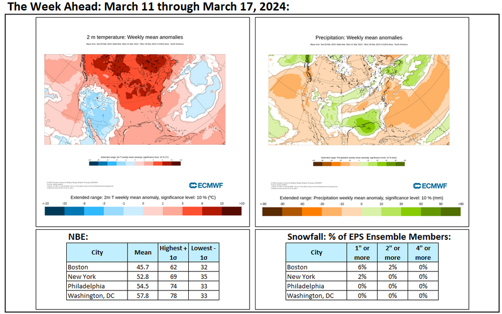
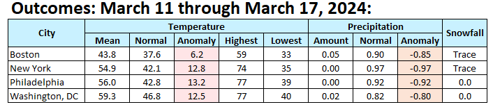
Final numbers for an exceptionally warm and very dry week:
-
That includes interior sections e.g., NW NJ. I highly doubt that Philadelphia, Newark, or New York City will see much if any additional snowfall.
-
Cooler air will push into the region. One shot will begin to arrive tonight. Another somewhat stronger shot will arrive Wednesday or Wednesday night. The low temperature could approach or reach freezing on Thursday morning or Friday morning in New York City. Milder air will begin to return during the weekend. The closing days of March could turn warm. No significant snowfall appears likely in the northern Middle Atlantic region through at least March 20th. The probability of an unprecedented second consecutive winter with less than 10" seasonal snowfall in New York City's Central Park has continued to increase. It is now very likely that New York City will finish the 2023-2024 snow season with less than 10" of seasonal snowfall. Records go back to 1869. The ENSO Region 1+2 anomaly was +1.0°C and the Region 3.4 anomaly was +1.4°C for the week centered around March 6. For the past six weeks, the ENSO Region 1+2 anomaly has averaged +0.98°C and the ENSO Region 3.4 anomaly has averaged +1.53°C. A basinwide El Niño event is ongoing. The ongoing El Niño event will continue to fade during March. Neutral conditions could develop during the spring. The SOI was -3.88 on March 16. The preliminary Arctic Oscillation (AO) was -1.234 today. Based on sensitivity analysis applied to the latest guidance, there is an implied 99% probability that New York City will have a warmer than normal March (1991-2020 normal). March will likely finish with a mean temperature near 47.9° (5.2° above normal).
-
Week ahead numbers:
-
Fantastic photos.
-
Mild conditions will persist through tomorrow. Afterward, it will turn cooler with highs only in the middle and upper 40s in New York City and near 50° in Philadelphia. However, as has generally been the case this winter, no direct Arctic shots are likely. As a result, the cold will likely not be severe for the season. Moderation will likely occur later during the start of the following weekend with the temperature returning to the lower 50s. The closing days of March could turn warm. No significant snowfall appears likely in the northern Middle Atlantic region through at least March 20th. The probability of an unprecedented second consecutive winter with less than 10" seasonal snowfall in New York City's Central Park has continued to increase. It is now very likely that New York City will finish the 2023-2024 snow season with less than 10" of seasonal snowfall. Records go back to 1869. The ENSO Region 1+2 anomaly was +1.0°C and the Region 3.4 anomaly was +1.4°C for the week centered around March 6. For the past six weeks, the ENSO Region 1+2 anomaly has averaged +0.98°C and the ENSO Region 3.4 anomaly has averaged +1.53°C. A basinwide El Niño event is ongoing. The ongoing El Niño event will continue to fade during March. Neutral conditions could develop during the spring. The SOI was +11.39 on March 15. The preliminary Arctic Oscillation (AO) was -0.121 today. Based on sensitivity analysis applied to the latest guidance, there is an implied 98% probability that New York City will have a warmer than normal March (1991-2020 normal). March will likely finish with a mean temperature near 47.7° (5.0° above normal).
-
It will be interesting to see how things hold up should the newer guidance verify. I suspect that the Magnolias that aren’t in bloom might not bloom until April if the weather stays cooler. The Camelias could lose their blossoms. Most of the crocuses are already done blooming.
-
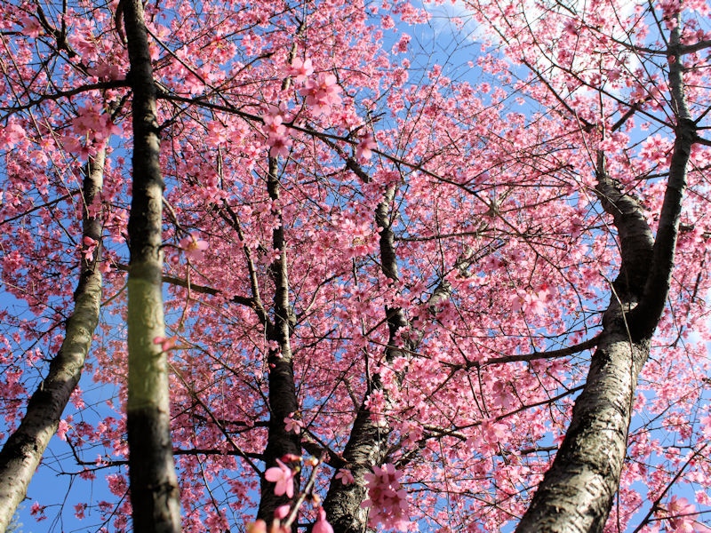
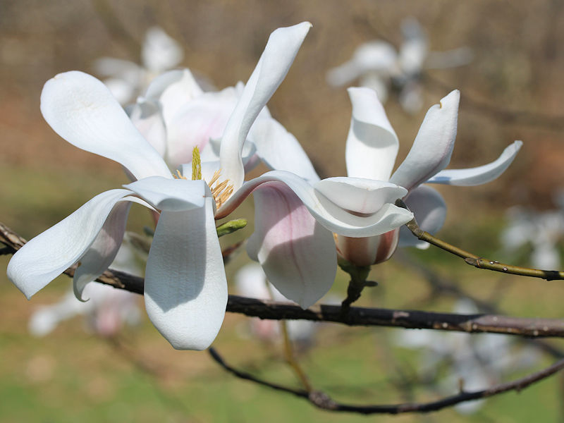
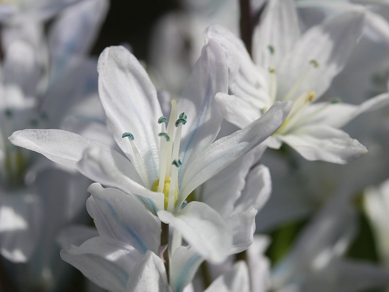
On account of the warmest first 15 days of March and the earliest 15-day period with a 50°F (10°C) or above mean temperature on record in New York City, the New York Botanical Garden has exploded into bloom. Some photos:


-
The 15-day average reached 50 during March 7-21, 1990. March 1990 saw an early shot of very cold air with the low temperature reaching 13 on March 7th. Six of the first eight days had lows of 25 or below with three days having highs in the 30s, including 33 on March 6th.
-
New York City saw the temperature average above 50F (10C) during March 1-15. The previous earliest 50F (10C) or above 15-day mean temperature occurred during March 3-17, 1977.