

donsutherland1
-
Posts
19,836 -
Joined
Content Type
Profiles
Blogs
Forums
American Weather
Media Demo
Store
Gallery
Posts posted by donsutherland1
-
-
14 minutes ago, LibertyBell said:
But was the reason for the extreme blocking the same as what we had in 1916-17? And has such extreme blocking always been historically rare, or is it only this rare in our new climate OR is it that in our new climate we need this kind of extreme blocking to get very high snowfall totals? Getting at least 50" of seasonal snowfall seems to require it.
There's no definitive answer in the literature. While 50" seasons remain possible at decreasing frequency, there will likely come a time when such blocking is necessary to assure the kind of sufficient cold for a 50" season.
-
 1
1
-
-
9 hours ago, LibertyBell said:
Interesting thing about 2010-11 which I remember you pointed out is that it was much more like La Ninas of old back in the 1910s which were very snowy and cold-- I wonder why that winter was so much like those winters from over a century ago?
The extreme blocking of December 2010 and January 2011 locked in the cold air. Once the blocking ended, the explosive snowfall and sustained cold were largely finished.
-
 3
3
-
-
Showers and periods of light rain are likely into tomorrow. Tomorrow and Tuesday will become noticeably warmer as the clouds yield to sunshine. Overall, the first week of May should wind up warmer than normal despite today's cool weather. Another shot of cooler air wil likely arrive on Thursday.
The ENSO Region 1+2 anomaly was 0.0°C and the Region 3.4 anomaly was +0.8°C for the week centered around April 24. For the past six weeks, the ENSO Region 1+2 anomaly has averaged -0.23°C and the ENSO Region 3.4 anomaly has averaged +0.98°C. The ongoing basinwide El Niño event is fading. Neutral conditions could develop later in the spring.
The SOI was +7.37 today.
The preliminary Arctic Oscillation (AO) was -0.285 today.
-
1
-
-
1 hour ago, snowman19 said:
@donsutherland1 JB this morning is hyping/wishcasting a very high Atlantic ACE tropical season. Why you ask? Because he wants to use that to say 95-96 (over a 220 ACE season) is an analog and add it to the analog list he already made of 10-11, 13-14, 14-15. You can read him like a book
He is stirring up a "Witches' Brew" of analogs for which the selection seems more astrological than scientific in nature. 1995-96 was a much weaker La Niña event than is currently forecast with a PDO+. 2010-11 featured extreme blocking. 2013-14 was a Neutral ENSO event. 2014-15 was an El Niño winter. It should be noted that every strong La Niña since 1950 featured a negative PDO. These discontinuities suggest that there is no objective framework behind the analog selection. Very likely, his desire to forecast a cold and snowy winter (possibly as an argument that winters aren't warming, an argument he lost long ago) is the guiding force driving his emerging winter idea. That his past two winter forecasts have been debacles does not seem to have discouraged him from trying again. Random chance may sometimes intervene, but the lack of an objective forecasting framework assures that he won't see consistent forecasting success.
-
2
-
-
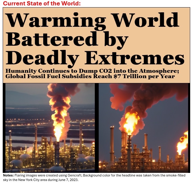
It is now 1,000 days since the IPCC declared that it is “unequivocal” that human activities have warmed the climate. No country has even considered setting targets for beginning a phaseout of the fossil fuel burning responsible for climate change. Meanwhile, major floods swamp parts of Texas, Brazil, and China while exceptional heat bakes parts of Brazil and Southeast Asia.
-
 1
1
-
-
17 minutes ago, LibertyBell said:
I love your enso predictions but can we get a prediction on the AO and NAO,, Don, when do you think it will turn positive?
They both might turn positive for a period later next week, but sustained positive regimes may not occur until later in the month.
-
1
-
-
Showers and periods of rain are likely tomorrow into Monday. A general 0.25"-0.50" of rain is likely. It will be unseasonably cool with the high temperature reaching only the upper 50s in much of the New York City area and low 60s in southern New Jersey and Philadelphia. Monday and Tuesday will become noticeably warmer. Overall, the first week of May should wind up warmer than normal.
The ENSO Region 1+2 anomaly was 0.0°C and the Region 3.4 anomaly was +0.8°C for the week centered around April 24. For the past six weeks, the ENSO Region 1+2 anomaly has averaged -0.23°C and the ENSO Region 3.4 anomaly has averaged +0.98°C. The ongoing basinwide El Niño event is fading. Neutral conditions could develop later in the spring.
The SOI was +3.16 today.
The preliminary Arctic Oscillation (AO) was -1.742 today.
-
1
-
-
4 hours ago, LibertyBell said:
do we still have that -NAO?
unbelievable how we dont get them in winter, but we get them now
Yes. We have an AO-/NAO-
-
7 hours ago, GaWx said:
New from JB:
“Now the CFSV2 is trying to forecast a warm PDO for the winter”
“this would resemble a blend of the SST of 10-11,13-14,14-15”

Once again, he’s relying on what I feel are bogus WB CFS SSTa maps like the one above. Yes, that looks like a +PDO. But it doesn’t matter if it is bogus like I think it is. Why does it have the warmest Pac waters, other than near Japan, just off N.A. and a 1,000 by 4,000 mile area of cold waters in the W to CPAC (to just N of Hawaii)??
To compare, here’s the -PDO shown on the latest TT CFS SSTa map for NDJ using 1984-2009 climo (DJF not out yet on TT): is orange where huge blue WB area is (including N of Hawaii) and only yellow/white (cooler) just off N.A. So, TT -PDO for NDF vs WB +PDO for DJF for the same model! You can’t make this stuff up!

By the way here’s TT CANSIPS for DJF: strong -PDO

IMO, the probability of a PDO+ is very low given the ENSO forecast. Moreover, the NCEP version of the CFSv2 maps shows no PDO+ developing through the October-December period (end of its timeframe). The WeatherModels version shows PDO- for all three winter months. I suspect WxBell's maps are incorrect. As Winter 2024-25 is still in fantasyland, I can't completely rule out the prospect, but I think even from this far out, such an outcome is very unlikely.
-
1
-
1
-
-
Tomorrow will be partly to mostly cloudy and a bit cooler than today. Showers and periods of rain are likely Sunday into Monday. Sunday will be unseasonably cool with the high temperature reaching only the upper 50s in much of the New York City area and low 60s in southern New Jersey and Philadelphia. Monday and Tuesday will become noticeably warmer. Overall, the first week of May should wind up warmer than normal.
The ENSO Region 1+2 anomaly was 0.0°C and the Region 3.4 anomaly was +0.8°C for the week centered around April 24. For the past six weeks, the ENSO Region 1+2 anomaly has averaged -0.23°C and the ENSO Region 3.4 anomaly has averaged +0.98°C. The ongoing basinwide El Niño event is fading. Neutral conditions could develop later in the spring.
The SOI was +3.24 today.
The preliminary Arctic Oscillation (AO) was -2.674 today.
-
The region experienced a wide range of temperatures. At Islip, the high was 63°. Central Park reached 79° Meanwhile, Newark hit 90° and Philadelphia reached 90° (old record: 89°, 2010).
Tomorrow will be noticeably cooler than today across most of the region with the temperature rising mainly into the upper 60s across the region. Overall, the first week of May should wind up warmer than normal, even as there will be considerable variability in the daily temperatures.
Showers and periods of rain could arrive during the weekend. Sunday into Monday could be the wettest period.
The ENSO Region 1+2 anomaly was 0.0°C and the Region 3.4 anomaly was +0.8°C for the week centered around April 24. For the past six weeks, the ENSO Region 1+2 anomaly has averaged -0.23°C and the ENSO Region 3.4 anomaly has averaged +0.98°C. The ongoing basinwide El Niño event is fading. Neutral conditions could develop later in the spring.
The SOI was -0.52 today.
The preliminary Arctic Oscillation (AO) was -2.648 today.
-
 1
1
-
-
14 hours ago, snowman19 said:
I am referring to the potential volcanic effects yes. I don’t think AGW is going anywhere anytime soon, in fact, it may even get worse
@donsutherland1 Thoughts?
AGW will almost certainly grow worse. There's little indication that global fossil fuel emissions will begin to decline significantly over the near- and medium-term. That will probably add another 0.1C-0.2C background warming globally toward the end of the decade. By 2030 readings close to 2023 levels might be the norm. By then, there will probably be a clear signal for declining snowfall in the NYC area that will stand out from any plausible case for internal variability.
-
2
-
-
Tomorrow will bring a taste of June with readings rising into the 80s across the region. Hot spots could approach or reach 90°.
Overall, the first week of May should wind up warmer than normal, even as there will be considerable variability in the daily temperatures.
Showers and periods of rain could arrive during the weekend. Sunday into Monday could be the wettest period.
The ENSO Region 1+2 anomaly was 0.0°C and the Region 3.4 anomaly was +0.8°C for the week centered around April 24. For the past six weeks, the ENSO Region 1+2 anomaly has averaged -0.23°C and the ENSO Region 3.4 anomaly has averaged +0.98°C. The ongoing basinwide El Niño event is fading. Neutral conditions could develop later in the spring.
The SOI was +6.53 today.
The preliminary Arctic Oscillation (AO) was -1.981 today.
-
11 hours ago, LibertyBell said:
Don what's causing all this variability? Is the SE Ridge not strong enough to take over?
We're still in the seasonal transition. Variability is often higher at this time of year. Blocking has continued to occur. But when the warmth arises, it overperforms.
-
1
-
-
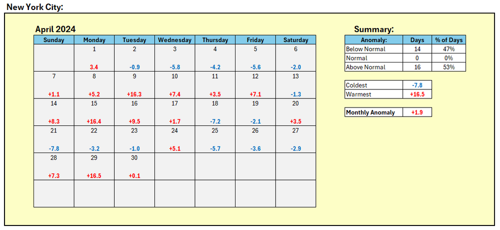
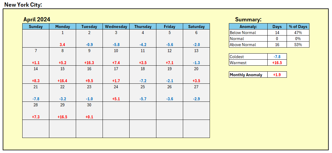
April's daily anomalies for NYC:
-
1
-
-
Clouds broke for some sunshine today in the New York City area where the monthly mean temperature finished at 55.6° (1.9° above normal) after a high temperature of 66°. Farther south, Atlantic City and Philadelphia saw the mercury again reach the 80s. Some showers or perhaps thundershowers are possible tonight but drier weather should return tomorrow.
May should see the first week wind up somewhat warmer than normal, even as there is considerable variability in the daily temperatures. Overall, May looks to wind up on the warm side of normal.
The ENSO Region 1+2 anomaly was 0.0°C and the Region 3.4 anomaly was +0.8°C for the week centered around April 24. For the past six weeks, the ENSO Region 1+2 anomaly has averaged -0.23°C and the ENSO Region 3.4 anomaly has averaged +0.98°C. The ongoing basinwide El Niño event is fading. Neutral conditions could develop later in the spring.
The SOI was -3.82 today.
The preliminary Arctic Oscillation (AO) was -1.058 today.
-
2 hours ago, snowman19 said:
This is a big deal. These are classic tropical volcanic eruptions back to back (cumulative VEI 5 possibly) injecting sulfate aerosols into the stratosphere. This definitely has implications for the winter….volcanic stratosphere
It will depend how much was injected into the stratosphere. The earlier eruption produced about 0.5 terragrams of sulfur dioxide. About 5 terragrams reaching the stratosphere is required to have a significant short-term climate impact.
https://earthobservatory.nasa.gov/images/152716/a-blanket-of-ash-from-ruang
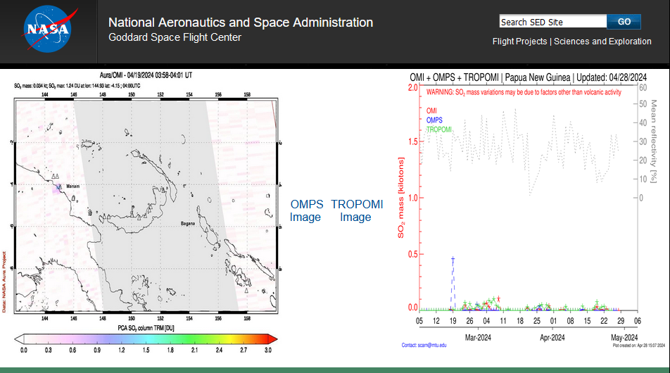
I haven't seen any data on the most recent eruption, yet, but it should be posted here in coming days:
https://so2.gsfc.nasa.gov/measures.html
Note: The chart in the above link shows total sulfur dioxide emissions, not solely those that reached the stratosphere.
-
3
-
5
-
-
DCA _ NYC _ BOS __ ORD _ ATL _ IAH __ DEN _ PHX _ SEA
1.1 1.2 1.1 0.8 0.9 0.9 0.5 0.5 0.7
-
Thunderstorms are moving across parts of the region this evening. A few locations could experience strong wind gusts and hail.
In the wake of today's early-season heat, readings will trend closer to normal levels for tomorrow. May should see the first week wind up somewhat warmer than normal.
The ENSO Region 1+2 anomaly was 0.0°C and the Region 3.4 anomaly was +0.8°C for the week centered around April 24. For the past six weeks, the ENSO Region 1+2 anomaly has averaged -0.23°C and the ENSO Region 3.4 anomaly has averaged +0.98°C. The ongoing basinwide El Niño event is fading. Neutral conditions could develop later in the spring.
The SOI was -2.31 today.
The preliminary Arctic Oscillation (AO) was -0.532 today.
Based on sensitivity analysis applied to the latest guidance, there is an implied near 100% probability that New York City will have a warmer than normal April (1991-2020 normal). April will likely finish with a mean temperature near 55.8° (2.1° above normal).
-
1
-
-
2 hours ago, LibertyBell said:
JFK also well over 80, Don?
I hit 84 here
JFK hit 82
-
1
-
-
87 at NYC.
-
3
-
-
1 hour ago, LibertyBell said:
both had record breaking hot stretches in the summer.
The evolving ENSO transition favors a hot summer. I suspect that many parts of the NYC area will have a shot at 100 this summer. We'll have to see if the heat penetrates Central Park's forest.
-
3
-
-
36 minutes ago, snowman19 said:
He will still be predicting cold and snow on Memorial Day weekend. He’s living in an alternative universe all to his own
You're probably right. Maybe he'll dig out the 1816 analog for June given his practice of using antiquated and irrelevant analogs.
-
 3
3
-
-
33 minutes ago, Rjay said:
Who's gonna tell metsfan?
JB has moved past what turned out to be his latest missed call and is talking about a pattern similar to 1966 and 1977 for the second week of May.
-
2
-


May 2024
in New York City Metro
Posted
Tomorrow and Wednesday will be unseasonably warm days with readings reaching the upper 70s and lower 80s across the region with the highest readings likely in and around Philadelphia. Overall, the first week of May will very likely wind up warmer than normal. Another shot of cooler air wil likely arrive on Thursday.
The ENSO Region 1+2 anomaly was 0.8°C and the Region 3.4 anomaly was +0.5°C for the week centered around May 1. For the past six weeks, the ENSO Region 1+2 anomaly has averaged -0.08°C and the ENSO Region 3.4 anomaly has averaged +0.85°C. The ongoing basinwide El Niño event is fading. Neutral conditions could develop later in the spring.
The SOI was +6.22 today.
The preliminary Arctic Oscillation (AO) was -0.285 today.