

Quincy
-
Posts
6,151 -
Joined
-
Last visited
Content Type
Profiles
Blogs
Forums
American Weather
Media Demo
Store
Gallery
Posts posted by Quincy
-
-
Pretty unusual to have such strong deep layer and low level shear coincident with enlarged low level instability, even if deeper layer CAPE profiles appear to be modest at best. A few point forecast soundings showed 0-3km CAPE in excess of 200 J/kg…
Looks like a narrow warm sector “wedge” will be conditionally favorable for supercells near and just SW of the Houston area. Storms along the cold front could initially start as semi discrete supercells. As SPC said, watch the triple point and along the warm front. Low level shear looks very impressive, but I do wonder if storm interactions will lead to a sloppy mess. Also, does anyone have a read on SSTs just offshore?
The low level jet goes bonkers Tuesday night, via models, with the NAM popping a maximum of 90 knots at 850mb. Could see a nighttime severe surge for areas farther NE toward the central Gulf Coast.
-
 2
2
-
-
Looks like two severe regimes later today:
1. Ozarks/Arklatex area. Warm sector could start firing off storms by early afternoon, but storm interactions and a tendency for convection to become elevated seem to be limiting factors. Not to mention that’s one of the worst areas to storm chase in the sub-forum.
2. Eastern North Texas into eastern Oklahoma. Convection allowing models are in fairly good agreement with semi-discrete storms initiating just east of I-35 by late afternoon. The parameter space is progged to be uncharacteristically favorable for early January. The main issue may be capping and storms not firing until right around sunset.
12z FWD sounding shows a substantial capping inversion around 850mb. The cap looks to allow CAPE to rise into the 1000-2000 J/kg range by 21-22z, but as mentioned, most convection may be suppressed until a bit later. We’ll see.
Tomorrow looks interesting over LA/MS, but the threat seems to be split across sub-forums and isn’t gathering much attention.
-
2
-
-
A Particularly Dangerous Situation (PDS) tornado watch is being considered for parts of East Texas, northwestern Louisiana and vicinity:
-
4 minutes ago, Powerball said:
In hindsight, this event was somewhat underhyped for DFW given the poor timing.
I also downplayed the early setup. A good example that you don’t need a lot of instability with an anomalous system like this. Timing is virtually irrelevant, if the parameters are in place.
-
5
-
-
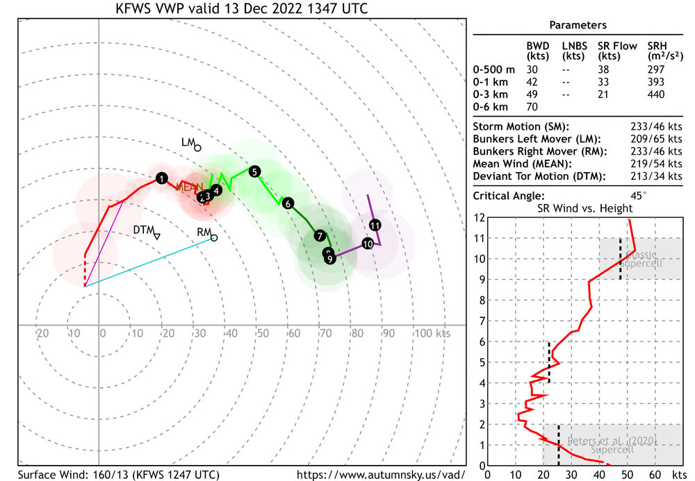
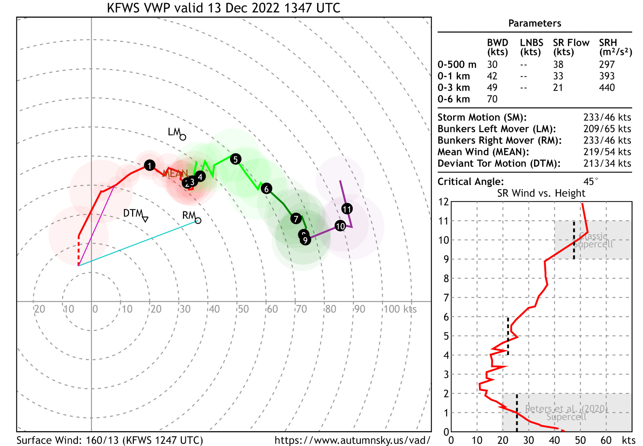
Here’s a look at the Fort Worth area VWP earlier this morning around the time of tornadic circulations. 42 knots of 0-1km shear and nearly 400 m2/s2 0-1km SRH. Very favorable for tornadogenesis, given sufficient low level instability.
-
 1
1
-
-
15 minutes ago, weatherextreme said:
If this system is producing during the early morning hours wondering what is going to happen come mid day/evening as it moves east. Towards the enhanced
Residual nocturnal low level jet contributed this morning with impressive boundary layer wind fields.
Typically you’d expect these threats to wane for a bit during the late morning, but we still have a 40-50 knot low level jet across eastern North Texas as of 15z, along with favorable 0-3km CAPE, enhanced vorticity and strong deep layer shear.
The tornado threat may never really ramp down, but I’d expect intensity and coverage of storms to spike by mid to late afternoon across East Texas. Open warm sector storms could become tornadic supercells and if some guidance is correct, we may see a potent scenario with the squall line breaking into a line of semi discrete supercells from East Texas into northwestern Louisiana
Even after dark the threat may only worsen, eastward across Louisiana. With relatively slow progression of the cold front, parts of Louisiana and Mississippi may see an “enhanced” threat of tornadoes tomorrow as well.
-
3
-
-
Forecasts show a robust trough sweeping across the Plains on Tuesday. More potent than the broader trough that accompanied the 11/29 moderate risk event in the same general area.
Wind fields look impressive. The GFS is rather aggressive with moisture return and instability surging northward into Arkansas. Most other guidance, including high resolution models and the ECMWF show a more confined area of favorable instability across east Texas into Louisiana.
It’s the cool season and with such wind fields, you don’t need much instability for trouble. Definitely a high shear/low CAPE setup.
The main question to me is, are isolated storms able to form ahead of the expected QLCS? Lapse rates are not nearly as impressive as 11/29, so this looks like mainly a wind and tornado threat. Less capping, but a potentially narrower warm sector, especially if high resolution guidance is correct.
Some key details need to be ironed out, but Tuesday definitely bears watching. Not sold on Tuesday AM pre-dawn severe, due to a stable near-surface layer, but who knows. (North Texas/southern Oklahoma)
I’m also mildly intrigued by a *possible* cold core setup over Kansas. Maybe it’s too late in the season, but steep lapse rates and strong wind fields suggest a non-zero severe risk could evolve closer to the surface low in Kansas.
In December, we chase?
-
3
-
-
18z SHV (Shreveport) sounding sampled 8.4 C/km mid-level lapse rates. Not only high end, but exceeds the observed maximum for late November:
-
3
-
-
Several factors seem to point toward higher-end potential today across the region. Many have been discussed above.
Lapse rates: 15z mesoanalysis shows mid-level lapse rates of 7-7.5 C/km across much of Louisiana and western Mississippi. A broad area of >8 C/km exists over East Texas. Typically these events “underperform” in terms of hail production in the Mississippi Valley, but you could see quite a bit of hail, especially across LA/AR/E TX.
Instability: Thanks in part to steep lapse rates aloft, instability profiles also appear to become uncharacteristically large for such a cool season event. Also, rich low-level moisture is rapidly being transported north and east. Note lower 70s dew points already in place from SE TX into S LA. This is supporting enlarged low-level CAPE, which is a key variable with respect to significant tornado events.
Shear: Both deep layer and low-level shear will easily be supportive of severe/sig severe. Also note a more westerly component to the upper level flow than we tend to have in place. WSW/SW, as opposed to the SSW flow we often see when big troughs trigger moderate risk events in the region.
More thoughts on the upper level support… We see a broad trough impinging on the area. This is allowing the steeper lapse rate plume to overspread moist low levels. Too often we see a barreling trough with a messy QLCS mode. While convective evolution could still get messy, the shear vectors do favor discrete or at least semi discrete modes for several hours.
A few limiting factors: Despite a more westerly than southerly component to the upper level flow, deep shear vectors are still fairly parallel to the initiating warm conveyor belt (SW to NE). This could result in bands and clusters of supercells, full of mergers and other storm interactions. Still, backing of wind fields is creating sickle-shaped low-level hodographs, in addition to elongated deep layer hodographs. Finally, low-level lapse rates will probably remain fairly marginal for a while. This may cap the ceiling a bit, particularly early in the event.
The threat should really ramp up late this afternoon and, unfortunately, continue into the evening hours with eastward extent across Mississippi.
Hopefully awareness is there and impact to life and property is minimized.
-
6
-
1
-
-
28 minutes ago, rnj79 said:
I am in Baton Rouge.
Was there any shifts/expansions in the risk area with the 7am update?
The slight, enhanced and moderate risk areas were essentially unchanged. The marginal risk was expanded slightly farther west across East Texas.
-
1
-
-
Wildfires in NW Oklahoma today. I don’t think I’ve had any rain here in Moore in a month. There were a few days in July with scattered storms west and north of here, but that’s about it. Either 7-10 split or they fizzled before making it here. Barely any rain since the start of June.
-
Witnessed a tornado in central Kansas a short time ago:
-
1
-
-
Another derecho could be forming across northeastern Kansas. Pressure falls are noted ahead of the convective system. Topeka’s 00z sounding sampled 1432 J/kg of DCAPE.
-
Been chasing the storm cluster in southwestern Nebraska. Keeping a distance to get some structure photos, but there may have been a brief tornado or two underneath there. (Via other storm chasers)
-
2
-
-
To echo @Chinook, forecast hodographs look rather lengthy, thanks to the substantial shear mentioned above. If storms don’t get too clustered, you could see at least a couple long-track, intense supercells. Severe hail would be the most likely hazard.
Low-level SRH is forecast to modestly improve after 00z, but I’m not sure the tornado threat will be fully realized. This is thanks to storms tending to merge and grow upscale, but a tornado or two could form.
Other supercells seem probable across the Colorado Front Range and possibly northeastern New Mexico as well.
Tuesday could be a rather active day across the region…
-
It’s nice to see rain and storms across the southern High Plains. Hopefully the pattern continues so we can keep chipping away at the drought.
-
Chased down in he Permian Basin today, because June decided to start off with another crashing cold front.
Going to take a break from chasing for a while. The pattern looks below average anyway.
-
1
-
 1
1
-
-
Several semi-discrete supercells formed from the Texas panhandle into northern/western Oklahoma and southern Kansas on Tuesday. I had pretty low expectations going into the day, so I’d say the storms outperformed, despite being HP beasts.
-
1
-
-
Started the day in Sioux City and made the decision to go south. It was a race against the clock, but I opted to target eastern Kansas. I chased (or attempted to) a couple of semi-discrete supercells in the Flint Hills, but with trees and lack of roads, I bailed south for isolated cells closer to the Oklahoma border.
Those storms started to fade rather quickly, but I was able to get a couple of photos of the southernmost cell, before calling the chase off.
-
1
-
-
54 minutes ago, Wmsptwx said:
Why have they been so bullish if it looked sketchy?
Well, shear/instability are there. The parameter space in Minnesota is high-end with some anomalous values, but that doesn’t mean the setup was going to produce a bunch of discrete supercells.
I suspect we see some QLCS tornado reports. Kansas is still iffy, but maybe they squeak out a tornado or two around sunset. Even there, storm modes have been mixed.
-
9 minutes ago, Wmsptwx said:
So far nothing really discrete…hmmm.
Not really a big surprise. Also doubts down in Kansas, but the event is still young.
-
Late morning weather map:
-
Higher-end wind profiles for sure…
-
Here’s your giant hail:
Severe Weather 2-22-23
in Central/Western States
Posted
Models have consistently shown strong wind fields, including a 100+ knot 500mb jet, overspreading the Mid-South Wednesday afternoon. It looks like instability will be quite limited, so my initial thinking would be for mainly a damaging wind threat.