

Quincy
-
Posts
6,138 -
Joined
-
Last visited
Content Type
Profiles
Blogs
Forums
American Weather
Media Demo
Store
Gallery
Posts posted by Quincy
-
-
13 minutes ago, forkyfork said:
why the sref for anything
It’s guidance. Almost all guidance has some utility. You can identify trends, spread and uncertainty. Just keep in mind the usual biases.
I’ll grant you all that the SREF should not be the preferred or only guidance you look at with tropical cyclones.
-
26 minutes ago, CoastalWx said:
Honest question. Why the SREF for tropicals??
Because I’m bored and I like that it shows the low centers.
I mainly use that page for severe. But it’s really not that much different than posting 12km NAM stuff.
3km NAM coming into range soon. That’ll be fun

-
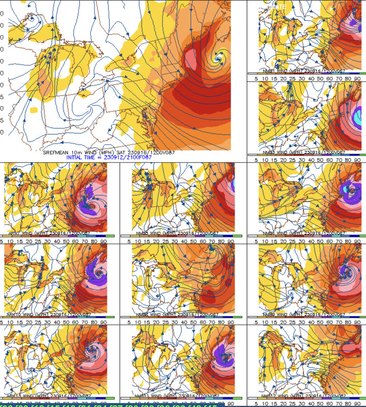
09z SREF coming in, maybe a tick east? The odd thing is that the usually amped ARW members that were all on the western envelope, have seen some movement east. On the other hand, several NMM members have come west.
The mean takes the center over the southwestern most tip of Nova Scotia. About 10 or 11 members out of 26 show a New England landfall. The consensus camp is into NS, but there’s more spread than the last run, as another cluster likes Maine.
-
Just now, WinterWolf said:
And stronger too.
On these more SW and W ideas, the storm is stronger and retains much more of its strength and core it seems.
Yup. Less phasing and interaction with the trough. Retains more tropical characteristics.
Need to see if I can fix that gif
-
GEFS trend from 18z
-
 4
4
-
-
Another bump or two like this and big yikes
-
2
-
-
Just now, Sn0waddict said:
Definitely a lot more interesting for eastern New England.
-
1
-
-
At least a 100 mile correction west. 93hr is just about to make landfall near Bar Harbor.
-
1
-
-
At 54hr, noticeably farther SW
-
4
-
-
Food for thought
-
3
-
-
Here’s the old 18z GEFS trend loop. Notice the slower trend, more west and stronger wind field. I’d expect the trend to continue with the rest of the 00z suite. Buckle up.
-
6
-
-
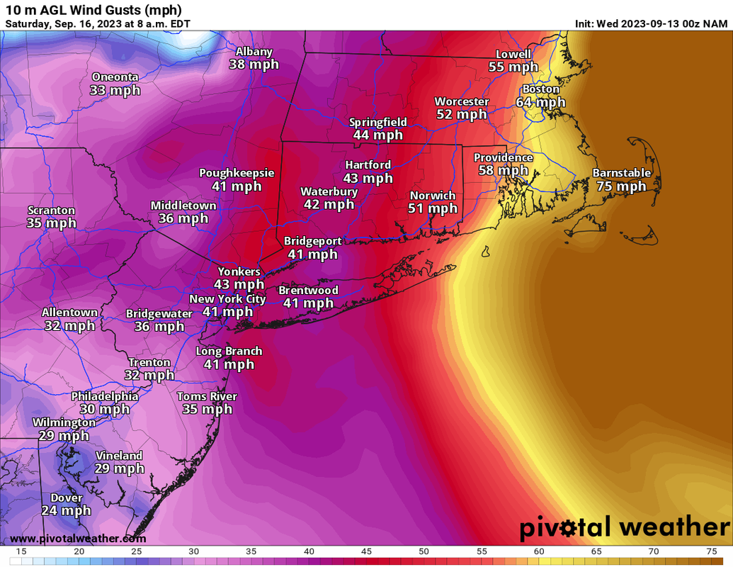
NAM wind gusts, FWIW
-
1
-
 1
1
-
-
Just now, ineedsnow said:
at hr78 getting pulled west oh boy oh boy
Movement from 78-84 hours looks pretty damn NW lol. Too bad it’s weenie range
-
1
-
-
The NAM evolution is something. Through 72 hours, it’s still a bit south, but the key is that there’s virtually no phasing with the ejecting shortwave. Result is slower movement and solid warm core retention. Not only is it not getting pulled northeast as fast, but it still looks like a formidable cane.
-
2
-
-
FWIW, NAM is slower, but the shortwave across New England late week is trending north slightly. This combined with the slower cane movement might allow for a longer northward trajectory, rather than getting pulled out NNE/NE like typical climo?
-
2
-
-
8 minutes ago, Typhoon Tip said:
Coming in from the southeast would be historically rare if not unique
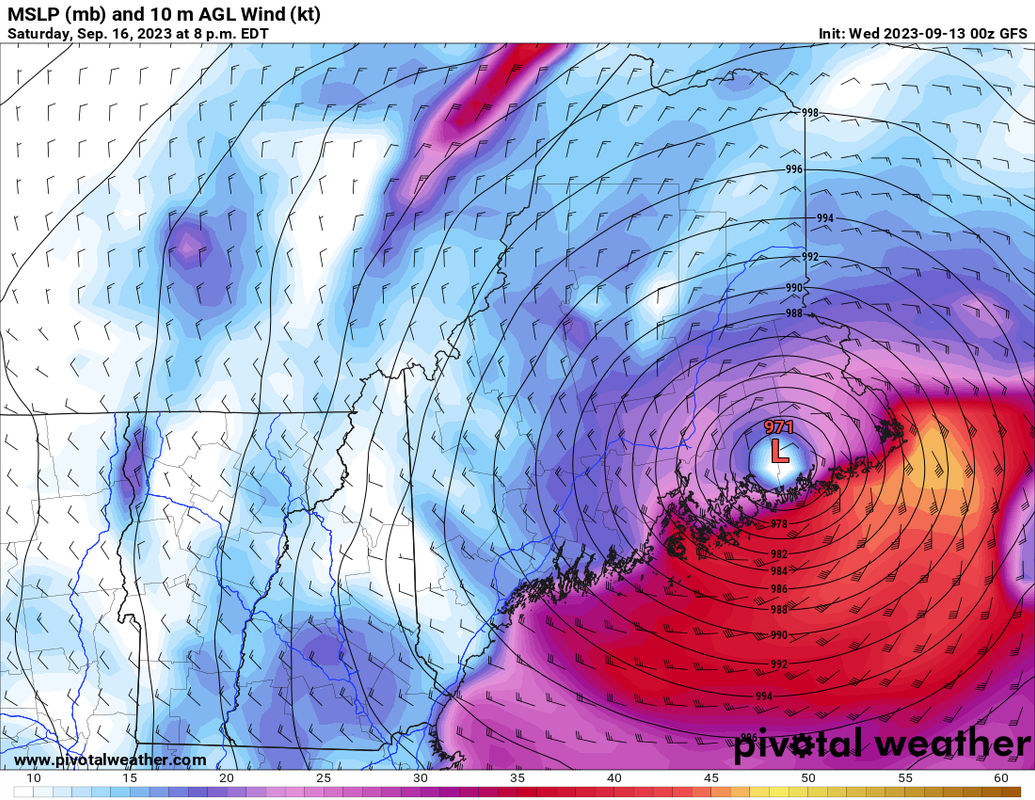
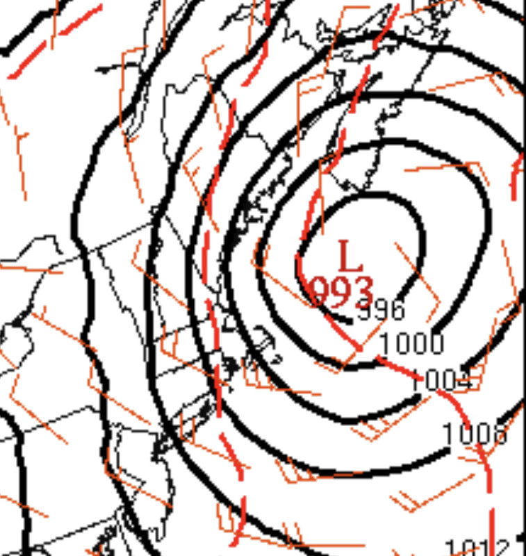
Even if this thing stays east and skirts Maine, that’s an ugly look for the coast from the Cape, right up to Maine. The guidance I’m looking at retains a fairly robust wind core on the west side. Pretty remarkable for this latitude.
Using the SREF as a sample because I like the tighter graphic, but even the EPS mean wind field is fairly symmetrical and largely intact on the west side.
-
4
-
 1
1
-
-
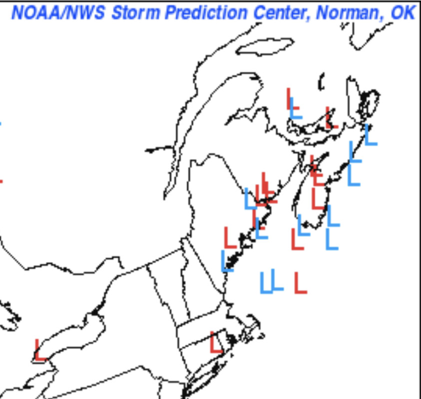
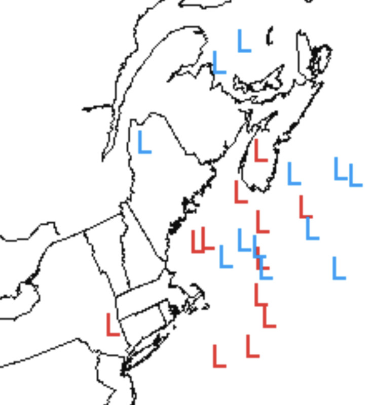
21z SREF low centers, in weenie range, but:
-
3
-
-
SREF is trending west as well ASOUT
On a trajectory for Maine
-
2
-
-
9 hours ago, Powerball said:
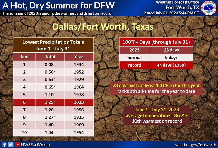
I find it interesting that prior to this year, all of the dry summer periods occurred prior to 1980. You also have to wonder if the dry conditions helped support the heat, to some degree. (Borderline days where moister existing conditions would have supported upper 90s, while drier soil allowed temps to crack 100+)
Either way, it’s definitely been an anomalous pattern across the Southern Plains this summer.
-
Had a one off, Hail Mary chase trip to south Dakota today and caught an intense, long-lived supercell. It spawned multiple tornado warnings, but the main stories were hail and prolific lightning production.
-
Lower 70s dew points across parts of eastern Colorado now. Convective initiation is underway just north of Flagler. Wouldn’t be surprised to see a few tornadoes given anomalously rich moisture on the High Plains, backed low level flow and extreme instability in place. (>4000 J/kg SBCAPE)
-
1
-
-
Two target areas today for late-day supercell thunderstorm potential: Near a surface low/warm front across the Northern High Plains and a more conditional threat near a remnant outflow boundary near the NE/SD border area.
-
1
-
-
Chased a few HP supercells in northeastern Nebraska today. Supercell potential ramps up more over the next few days…
-
A belt of enhanced flow looks to affect much of the Central Plains through the rest of this week. Expect daily severe weather threats during the afternoon/early evenings with MCS potential bringing bouts of heavier rains to parts of Nebraska, Missouri, Kansas and possibly even into Oklahoma.
No particular day stands out as a higher-end severe event, but isolated to scattered supercell potential continues for the foreseeable future.
-
1
-
Hurricane Lee--Glorified Nor'Easter or Legit Tropical? Near Miss or Direct Hit?
in New England
Posted
Even an east tick is going to still ugly for coastal eastern Mass. Especially Beverly toward Cape Cod Bay. N/NE fetch, gusts easily reaching 50-60+. Flooding is a real concern given the wind field size and trajectory.