

Quincy
-
Posts
6,139 -
Joined
-
Last visited
Content Type
Profiles
Blogs
Forums
American Weather
Media Demo
Store
Gallery
Posts posted by Quincy
-
-
Illustrating the upper level setup for tomorrow vs. yesterday. A few small differences, but the main change appears to be placement slightly farther NW and, probably, somewhat later convective initiation.
-
Isolated severe storms across the region today, but tomorrow dials up the risk again. In fact, tomorrow looks similar to yesterday.
A belt of unseasonably strong upper level flow in place from the Southern Rockies to the Lower Mississippi Valley with a shortwave ejecting toward KS/OK.
-
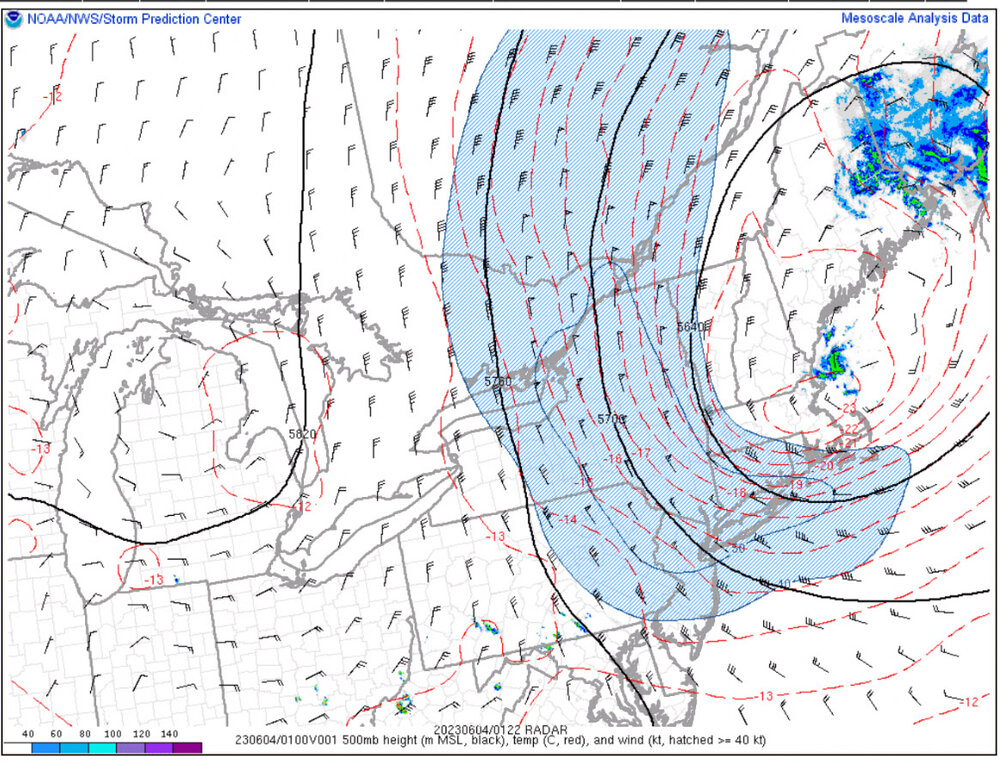
Wild atmospheric conditions around the Southern Plains tonight. I just encountered nearly tennis ball size hail from modest (at first glance) looking reflectivity returns.
00z FWD and OUN soundings have crazy elements as well:
-
 3
3
-
-
Seceral WoFS members show convective initiation across North Texas by 21-22z. That would not surprise me at all, given recent trends.
-
95/95 probabilities for large hail/sig hail
-
2
-
-
8 minutes ago, yoda said:
Interested in what kind of watches are issued. As the MCD says, it will be a tornado watch. However, with winds likely over 80 mph (I'm guess text will say to 90mph and hail to 4" in diameter)... could they go PDS just to cover everything even though no violent tornadoes are likely?
Interesting situation. I can’t imagine they’d go with a PDS tornado watch with relatively “low” significant tornado probabilities. Also, if storm mode stays relatively discrete, especially south of I-40, can’t see them going with a severe thunderstorm watch.
Maybe an initial tornado watch out west and wait for a later watch near I-35?
-
1
-
 1
1
-
-
40 minutes ago, radarman said:
FWD disco casually dropping mentions of Jarrell 97
Saw that. Was kind of odd. I almost posted an analog (5/15/03), but it shows a regional tornado outbreak and has a few key differences synoptically.
This is really a unique event given the time of year. I can’t say that there are many analogs that seem to closely match today. You could see mostly hailers with big wind later, given higher LCLs and modest low level shear. On the other hand, you could have a couple of strong/intense tornadoes, IF sustained storms manage to remain at least semi discrete, and can tap into better moisture and low level shear after 23-00z.
-
1
-
2
-
-
Looks like we’ll have several intense supercells today. The entire region from North Texas to the OK/TX panhandles looks to have a higher end parameter space.
I’d suspect storm modes get clustered/linear by early evening across central/northern Oklahoma. More discrete storms appear probable across southern Oklahoma and North Texas
DFW may be in the cross hairs as a tail end Charlie storm could tap into lower 70s dews and prove to become quite intense.
-
1
-
3
-
-
When you get the jet so far south in June… is when you get a northerly wind on the “cool” side of an outflow boundary with 5000+ CAPE and mid-70s dews. (DFW area)
Towers are attempting to go up near that boundary. Will be interesting to see if any updrafts can become sustained, given the conditionally volatile environment.
-
Absurd environment in place across the Louisiana/Mississippi vicinity this morning, for June standards. Strong west-northwesterly flow atop 70s dew points with the 12z JAN / Jackson, MS sounding sampling 72 knots of effective shear.
SPC has expanded the moderate risk outlook to cover areas from northeastern Louisiana to southwestern Georgia. Great discussion and also highlights the uncertainty. Just because the parameter space appears volatile, doesn’t mean there’s going to be an outbreak. However, model guidance suggests at least isolated intense supercells and the ceiling is quite high. We’ll see how it comes together.
-
1
-
-
Chased the Texas panhandle supercell until it started accelerating and producing grapefruit hail.
Debating on chasing tomorrow (Wednesday), but the lack of a LLJ makes we question life decisions if I go into the woods to “chase” big hailers. Such a shame that we’ll have huge buoyancy and crazy shear for this time of year.
Some high res progs show a 75 knot 500mb jet streak across AR/MS. Just ridiculous.
-
3
-
-
Looks like several several threats through this work week across the Southern Plains as an active southern tier jet pattern establishes.
Was woken up by an elevated supercell this morning around 4:45 AM. Other supercells continue as I type this.
Oklahoma/Texas, enjoy this week, because a building ridge means deep summer will soon lock in.
I’m eyeing the central/northern Plains around the d7-10 window for severe potential, hoping it’s not lost in the models like previous long range fantasy setups.
-
1 hour ago, andyhb said:
Lol Tues/Wed look done at this point, ULL over the Great Lakes is crushing/suppressing anything that tries to eject those two days.
Maybe done from a Southern Plains chasing standpoint, but a 50+ knot jet is still (most likely) going to streak across the south-central states.
Current progs show a target around the Arklatex, maybe back toward DFW. Messy terrain and sloppy HP storms, maybe, but 50-60 knot deep shear vectors out of the W/WNW overspreading 70s dew points and remnant EML could spell trouble. Even if it’s far from a chaser-friendly setup.
Wednesday is comical as the target may be suppressed down to near I-10 in Louisiana. More of a March/April setup than mid-June. It wouldn’t surprise me to see an HP slopfest in southern Louisiana. Then the death ridge builds a few days later. You go from brief summer to suppressed flow to deep sumner in Oklahoma in June. Welcome to jet weirding.
I am cautiously optimistic that week 2 lights up across the north-central U.S., assuming we don’t get a retrograding Great Lakes cutoff or a rogue western GOM hurricane.
-
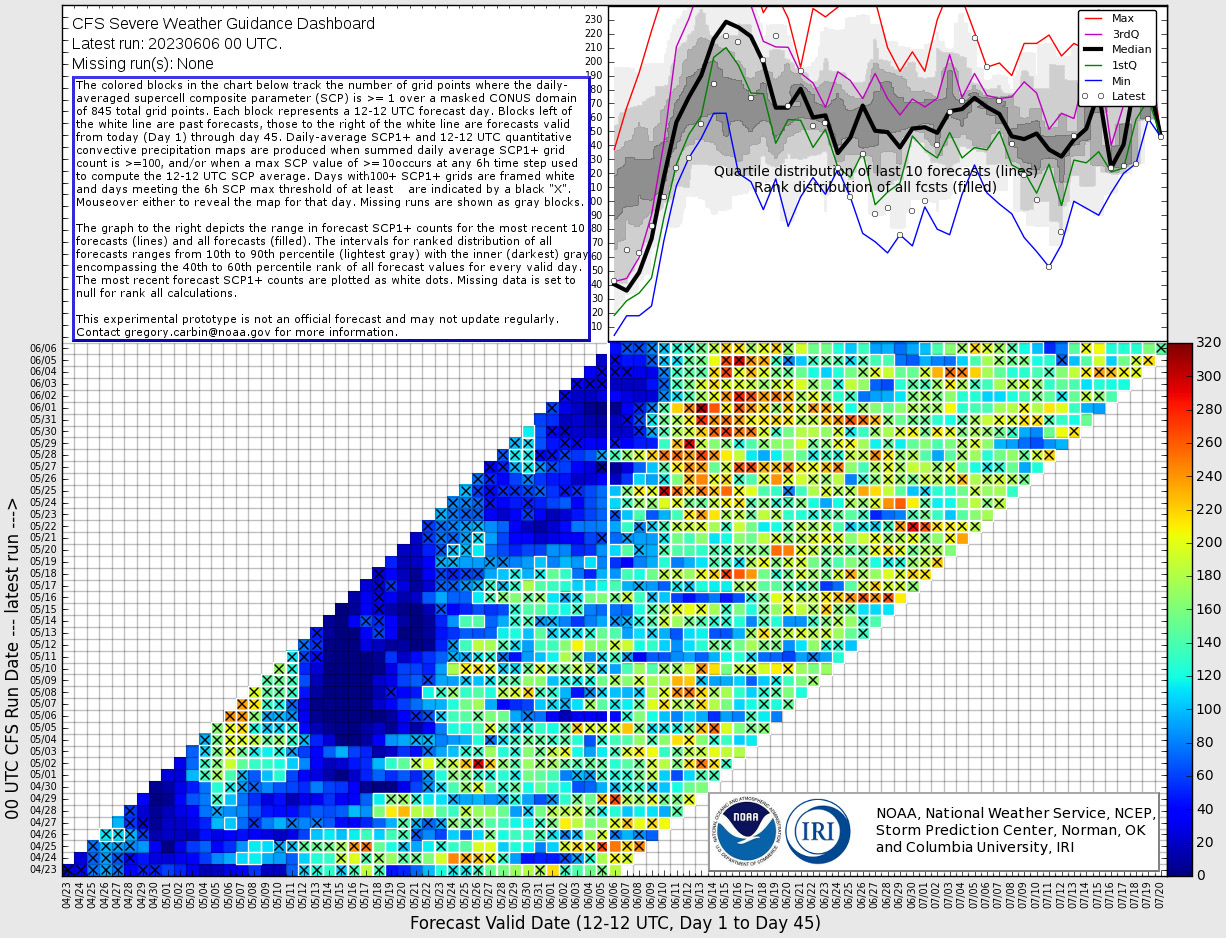
Model consistency continues to grow for the middle of next week, with respect to severe potential from the Southern Plains toward the Mid-South. EPS mean 500mb winds of 50-60 knots at such southern latitudes is impressive for Mid-June. You have to imagine some members are showing 60+ knots, which is high-end, given climatology.
FWIW, today’s CFS has shown its hottest run for late June, to-date, but long range progs will continue to vary…
-
2
-
-
There’s been a lot of speculation, but it appears increasingly probable that an uptick, quite possibly to above average levels, of severe thunderstorm activity occurs across the central United States next week. It may, perhaps, continue into late June, but that remains to be seen as ensemble data fluctuates.
It starts with a gradual breakdown a persistent Plains upper level ridge. While Great Lakes/Northeast troughing may persist, we’re moving into a time of year where it doesn’t take much troughing off the Rockies/High Plains to set off a series of severe thunderstorm threats. It should be stressed that just because there’s troughing with enhanced deep layer wind fields and favorable moisture, doesn’t mean we’re going to see a series of tornado outbreaks. For all we know, it could be a lot of heavy rain associated with mesoscale convective systems (MCSs), but after a quiet start to June, any way you slice it, severe threats should increase.
It starts with an anomalously far south (given time of year) trough ejection across the southern Plains around the Tuesday-Thursday (June 13-15 time frame). The result looks a lot like a May-type pattern, only to occur unusually late in the season.
At this stage, Oklahoma, Texas and eastward toward the mid-South could see a late season, final hurrah to their severe season.
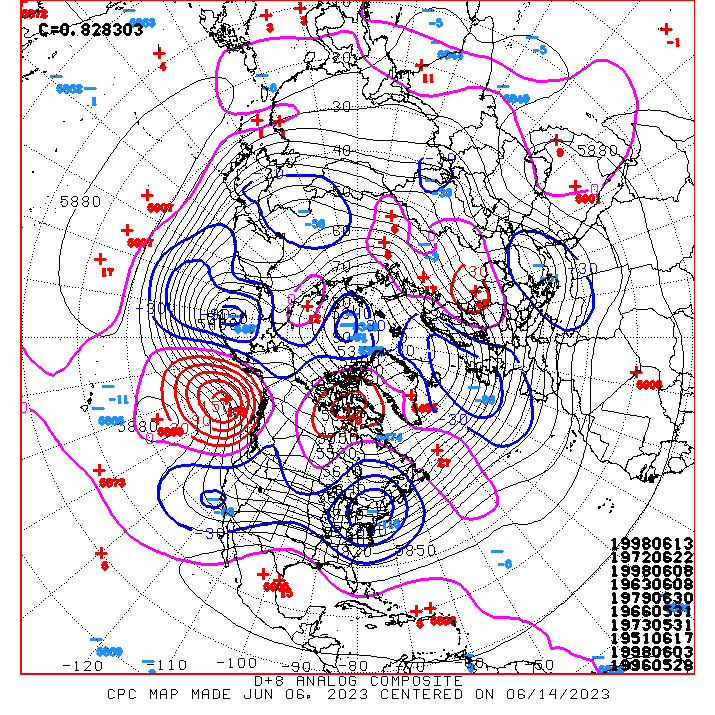
I dug up some analog data, based on the day 6-10 progs. The top 3 analogs all produced at least one late season (June) significant tornado in Oklahoma. (1963, 1972 and 1998). The 4th analog (1979) produced significant tornadoes in Arkansas, very late in their climatological season, on June 28th.
Several dates in June 1998 match the medium and long range progs. This was a month that featured above average tornado activity across the U.S., most notably across Oklahoma, Iowa and even Indiana and eastward toward the Appalachians vicinity.
CFS progs have consistently zeroed in on next week for the potential increase in supercell favorable environments. You will notice that the late June signal has been a bit more inconsistent.

-
1
-
1
-
-
3 hours ago, Damage In Tolland said:
Isn’t KTOL high enough to be at 500mb anyway?
-
 1
1
-
-
20 minutes ago, Damage In Tolland said:
Got the sunny breaks this afternoon. No 40’s so model fail. But no 60’s . We’ve had worse days in June for sure

I thought an UL low with NW flow over New England yields highs near 80F in June?
-
1
-
1
-
-
13 minutes ago, Damage In Tolland said:
Can sell that . Dry NW flow in June is 75-80
I wouldn’t take an operational run too literally this far out, but the peak of Mt. Tolland would probably max out in the 65-70F range with that setup.
-
1
-
-
-
Chased a couple of supercells in the Texas panhandle today. (Pictures are both from the second one, near Amarillo)
-
3
-
-
A complex setup today across Oklahoma. Arcs/bands of severe storms seem most probable across western to central Kansas today. Threat becomes more conditional to the south. Some additional thoughts in this thread:
-
-
SPC has upgraded parts of Kansas and Oklahoma to an Enhanced Risk tomorrow. This includes a significant tornado delineation from south-central Kansas into central Oklahoma.

The greatest risk for scattered to widespread severe thunderstorms appears to be across the western half of Kansas. A more isolated risk is anticipated farther south, but any storms that can initiate could be quite intense. Particularly across the western half of Oklahoma.
-
1
-
-
Day 1 Enhanced Risk from northeastern Colorado toward the CO/KS/NE border area. Driven by significant hail potential and 10% tornado risk via SPC.

I tend to think the tornado risk may not be as apparent, at least not with westward extent across Colorado, but we’ll see. CAMs have not showed much of a consistent signal out that way and right now there’s high pressure and cloudiness lingering.
My gut says northwestern Kansas has a somewhat better shot at tornadoes, given higher quality moisture, proximity to a frontal boundary (likely nudging north as a warm front later today). The caveat is that storm modes may be quite messy.
Will follow up in a bit for tomorrow with the upcoming Day 2 Outlook from SPC.

June/July 2023 Severe Discussion
in Central/Western States
Posted
Storms should be predominantly discrete/semi-discrete through 00z, especially around the Texas panhandle vicinity. Storm initiation with southward extent is a bit of a question mark, but Northwest Texas could get in on the action too, before storms grow upscale.
Agreed that most of the later stuff is messy. More heavy rain and wind anticipated for much of central Oklahoma and North Texas.