

Quincy
-
Posts
6,220 -
Joined
-
Last visited
Content Type
Profiles
Blogs
Forums
American Weather
Media Demo
Store
Gallery
Posts posted by Quincy
-
-
Looks like the best shot at severe convection will be in the vicinity of dryline/cold front intersection over south-central Kansas into north-central Oklahoma late Wednesday.

Farther south, moisture may be slightly richer, but weaker forcing and more modest lapse rates should exist. CAMs attempt to initiate a few isolated cells down toward I-40 near OKC.
Near or northeast of Wichita, linear storm modes are more likely as deep shear will be nearly parallel to a surging cold front.
Between these two areas is where the higher likelihood may exist for a few longer-lived discrete/semi-discrete storms.
Keeping an eye on this. We are getting into the cool season, so it’s more of a stronger shear / modest instability setup. Not a high-end scenario, but robust for late October standards.

The typical biases exist. HRRR may be mixing out low level moisture too quick and surging faster (too fast?) with the cold front. 3km NAM is juicier and is just a bit slower with frontal progression.
-
9 minutes ago, Voyager said:
Thanks for the detailed analysis, Quincy. I'm about 20 or so miles southeast of the I-80/I-81 interchange. Not sure what to expect as I seem to be on the edge of the good stuff.
Very intriguing setup. I’d definitely be out if I still lived in the Northeast.
Broyles just added a 10% contour in the day 1 outlook up across New York.

-
The NAM is absurd with an extreme parameter space. Verbatim, it would support a regional tornado outbreak. It has >2000 J/kg MLCAPE over the entire warm sector with >3000 J/kg near the warm front. That does not happen (rarely, if ever) in this region, coincident with highly favorable shear/hodographs.

The HRRR is much more toned down, but even with it mixing out, you still see a supercell-favorable environment with upwards of 1000 J/kg MLCAPE. I do realize the maps show SBCAPE, but forecast soundings show similar MLCAPE.

Typically a compromise between the two models gets you close to the end solution and that is definitely a yikes. CIPS analogs is even popping a 10% contour over parts of New York.

The only caveat with central PA is that as you get displaced more than about 150 miles from the low center, tornado and supercell probabilities decrease. You want to be closer to the inner core, where forcing and vorticity will be maximized. Also, with southward extent, expect veering of winds along the cold front. The shear profile near the warm front in New York looks ridiculous, but we’ll see how that works out. Warm fronts in the Northeast are notorious for being fickle in severe setups.

Still, several CAMs show at least isolated warm sector storms across parts of NW into the northern half of the state.
-
 4
4
-
-
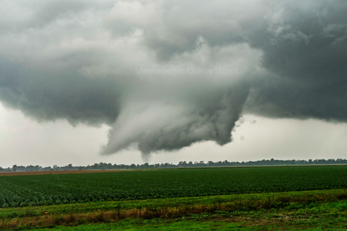
There were over 100 tornado warnings yesterday. It looks like it was one of the most active days of this year, one of the more active July days on record and it will probably rank high on the list in terms of tropical cyclone tornado outbreaks.
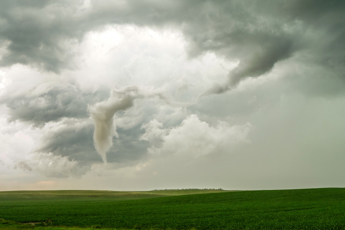
Chasing those things is hard. I intercepted at least three other tight circulations and had virtually not discernible visual on them. I got lucky with that tornado near Natchitoches occurred over flat terrain. Otherwise, there were too many terrain obstructions.
I’ll share more info once we get surveys and summaries of the overall event.
-
Looks like two main regimes, embedded tornadic circulations closer to the NE inner core and more discrete cells farther away east across Louisiana. And there’s the main convective arc near the LA/TX, but I think winds are more veered with southward extent.
This was the earlier tornado near Powhatan/Natchitoches:
-
2
-
-
Numerous tornadoes today across far eastern Texas and Louisiana. I chased this tornado a short time ago and more may be on the way.
-
2
-
-
I updated the title to cover threats through the 4th, before the pattern breaks down a bit.
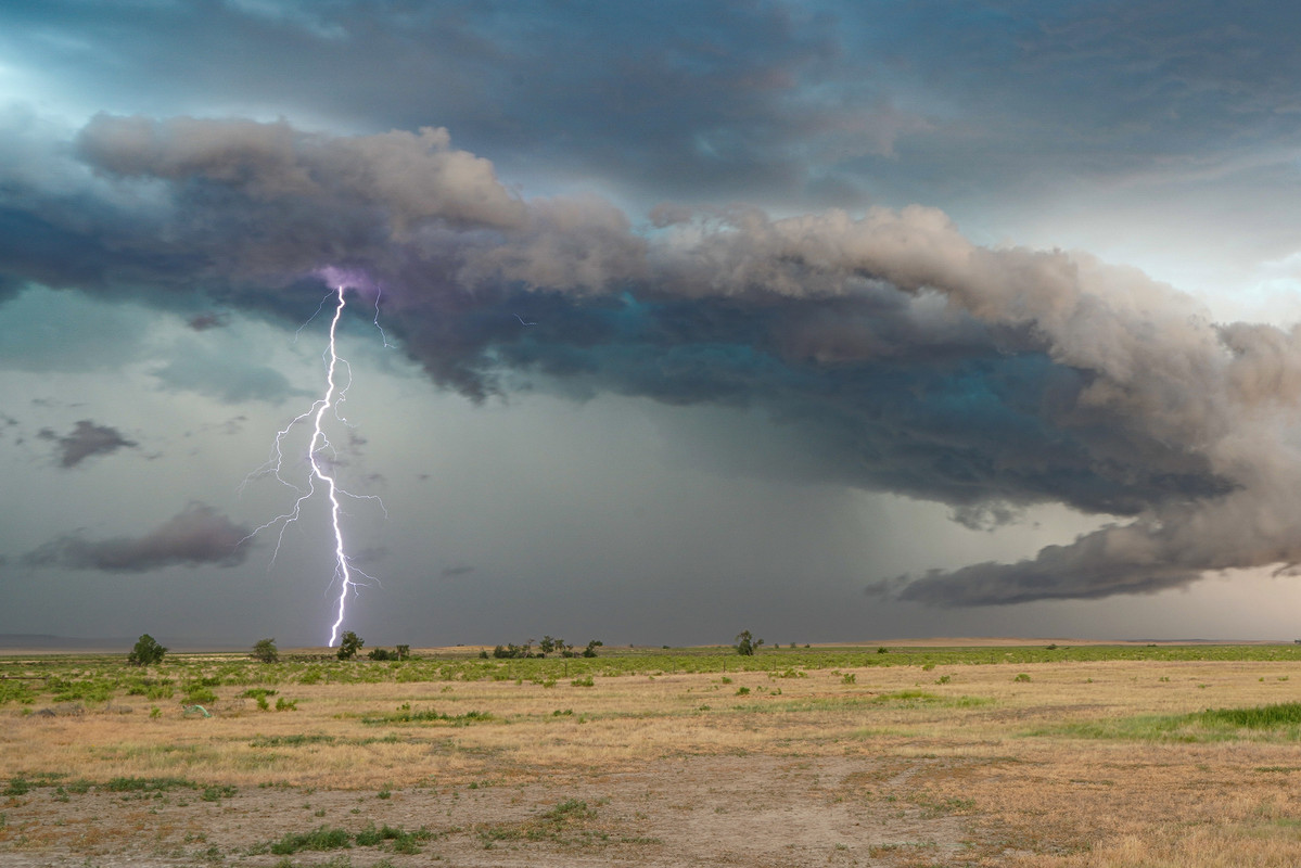
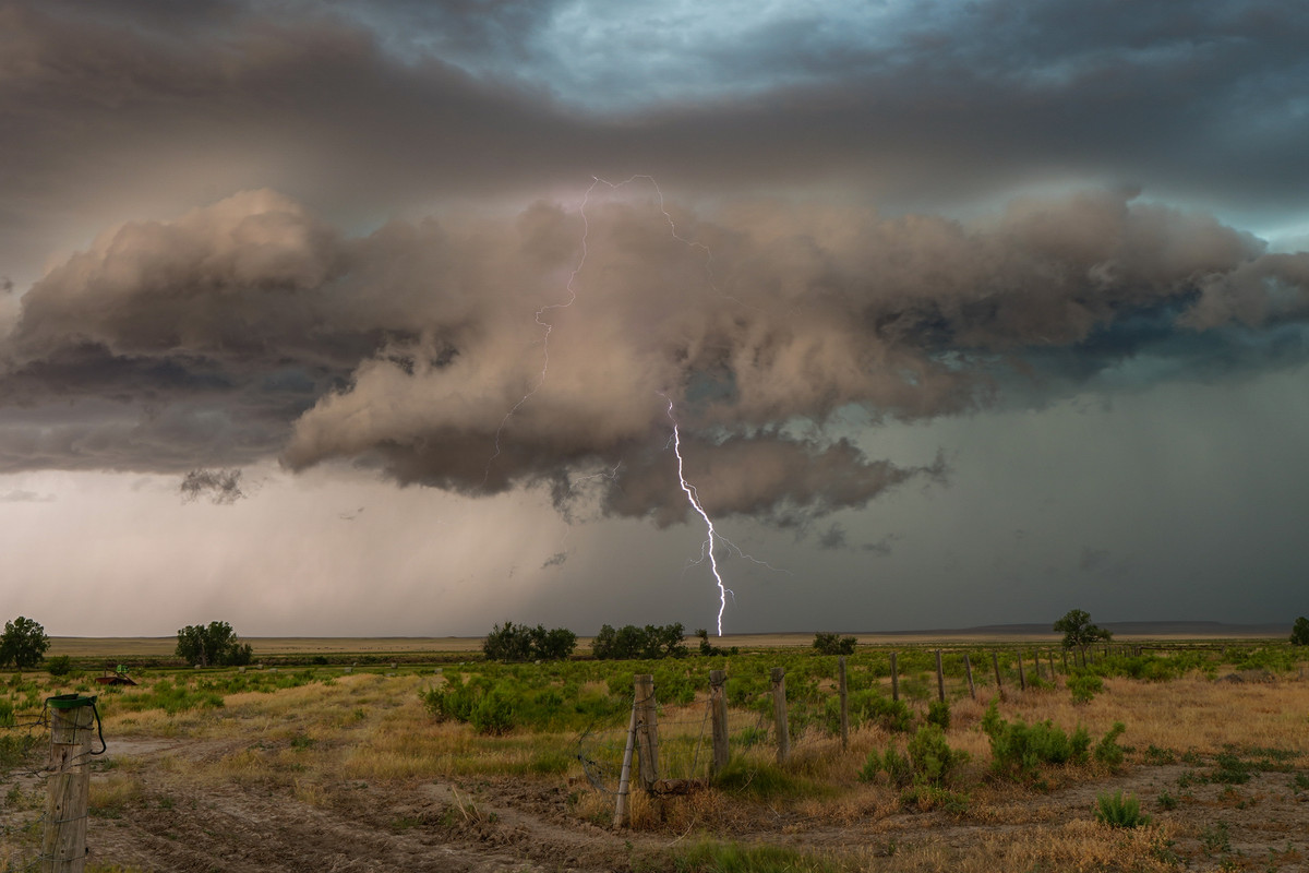
I chased marginally archers storms in eastern Wyoming yesterday. Nothing too remarkable, although there was a lot of lightning:
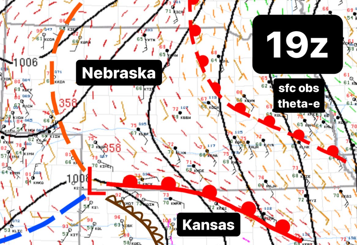
Today looks like a localized, conditional tornado threat near the Kansas/Nebraska border. The environment near a warm front across the area is very favorable for tornadoes. However, as the front lifts northward, residence time of storms along the narrow favorable environment may be limited. This combined with mixed storm modes casts uncertainty. Still, if a storm can thread the needle, you could see a few tornadoes and possibly a significant tornado.
Tomorrow, SPC has a day 2 enhanced risk from northeastern Kansas into northern Missouri and southern Iowa. The risk is wind-driven, but it’ll be the second day in a row with 5% tornado probabilities across portions of the Central Plains/Lower Missouri Valley.
-
More video from yesterday's tornado in northeastern Nebraska:
Today’s threat has been largely disrupted by the surging early day MCS. With a ridge over New Mexico and most of the favorable shear displaced to the NE of the region, only isolated pulse or transient supercell storms are anticipated across the Southern Plains.
Tomorrow, a shortwave ejects towards the Northern Rockies with seasonably strong deep layer shear targeting the western Dakotas.. SPC has issued a Day 2 enhanced risk for portions of the northern/central High Plains.
-
3
-
-
An active pattern has returned and should continue for at least a few days across the Plains and surrounding areas.
Just a really quick post because I’m wrapping up a storm chase, but I’ll add more analysis tonight or first thing in the morning.
I observed a few tornadoes in Madison County, Nebraska today. The first was a dusty hybrid tornado, while a second was a brief cone and the third was a more well defined, but brief tornado over Kalamazoo, NE:

I’m uploading better resolution video, but here’s a preview from Twitter:
There have been numerous other storms, including a supercell over north-central Oklahoma. I debated on staying local to chase that, but ultimately went for the target that had greater tornado potential. It looks like @andyhbwas on that storm:
-
1
-
-
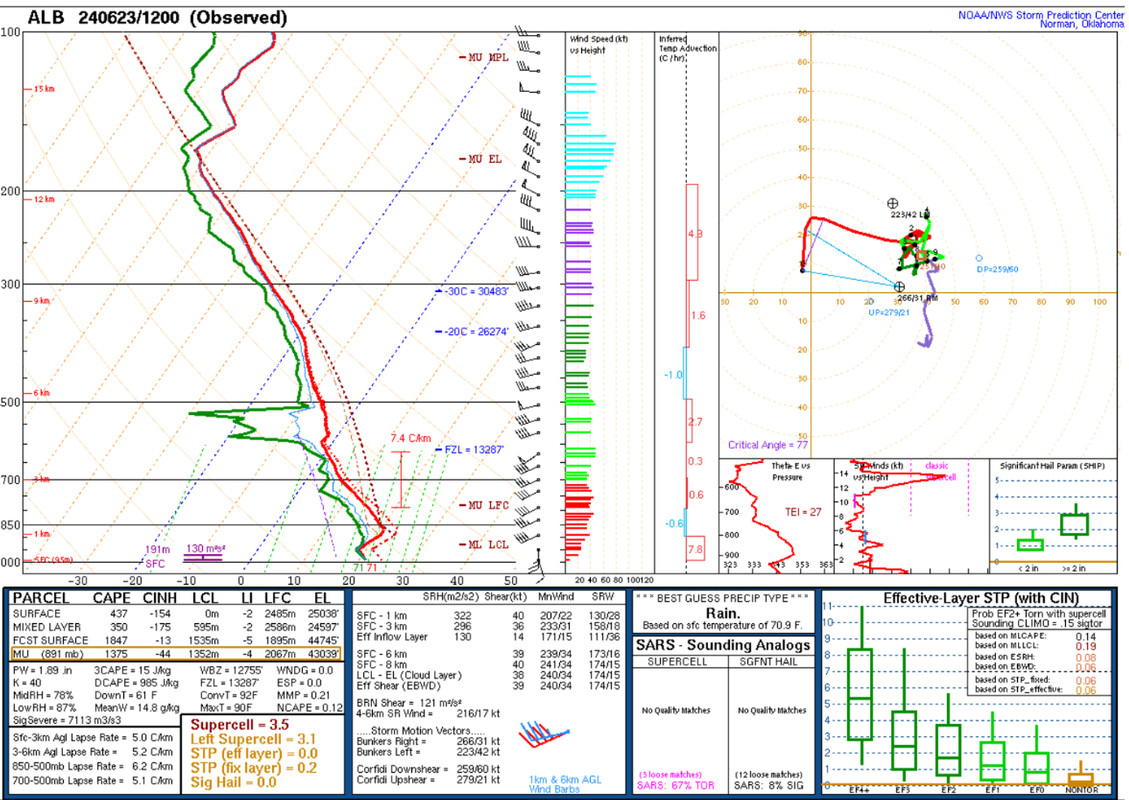
Special 18z ALB sounding is actually one of the more impressive ones I can recall, for local climo. Mid level lapse rates are marginal, but that was expected and is limiting this from being a more substantial event:

Subjective surface analysis places the warm front in southern NH with slow progress northward:

-
1
-
-
19z mesoanalyses:
Still some convective inhibition across New England, but looks like that will erode quickly from west to east.
Enlarged hodographs in place and increasing low level instability. It’s almost go time!


-
4
-
-
Latest HRRR shows a broken line of storms with the early trough as far south as NW CT at 21z. Could be a damaging day

-
Dews are definitely on the juicier side across Connecticut. You don’t want full clearing (unexpected anyway), as that could result in deeper mixing. Most guidance holds dews fairly steady, except to the north, as the warm front lifts.

This surface map will auto update hourly:

-
1
-
-
Here are the 12z HREF paintball maps with old runs omitted, valid at 21z/5 PM. The first graphic shows the high reflectivity signal, with attempted discrete storms across southern New England. The second graphic shows the stronger UH tracks, mostly confined to NH/VT:


-
6
-
 1
1
-
-
Most of the 12z CAMs show convection initiating along a trough across central Massachusetts around early to mid afternoon. The HRRR and RRFS are less enthused.
The HRRR shows semi discrete storms tracking over NH with this earlier round. The RRFS delays convection across most areas until late afternoon/early evening.
It’s really going to be a nail biter I think for southern New England. If there’s slightly better heating or dews run 1-2F higher than HRRR, closer to NAM progs, then you could see a storm or two go up in Massachusetts or northern CT.
Otherwise, more widespread convection seems likely during the evening, but with deep shear vectors more parallel to the boundary then, it should be a messy storm mode with bowing segments the predominant storm mode.
-
1
-
2
-
-
Definitely need some warming to erode the cap, especially in southern New England. That’s probably why CAMs have backed off on earlier activity. Satellite shows clouds socked in across most of New England, with some breaks in NY and around the Berkshires.
12z ALB sounding shows enlarged low level hodographs, but weak lapse rates and some messiness with the upper level wind profile too.
Assuming there are cloud breaks, there’s still the potential for a conditionally favorable environment around central Mass, otherwise there’s a higher probability for storms up in NH/VT. Not sure much if anything will be triggered early with subtle forcing. Unless you can get some daytime heating and erode the CAP.
-
2
-
 1
1
-
1
-
-
-
9 minutes ago, weatherwiz said:
The NAM/HRRR are spitting out some of the highest supercell/STP values I can remember here. Of course though that doesn’t mean everything, you still need mature enough storms to utilize the environment and that’s the question right now, how many can?
By the time the maps show those climatologically insane STP numbers, there will probably be widespread convection already. (21-22z)
Climo favors the 19-20z ish time frame for peak tornado occurrence in central New England, which happens to fit well with tomorrow’s setup.

If something big were to happen, you’d expect it to be around early to afternoon, either near the CT River valley or possibly near the warm front in NH. Later day storms will probably take on more of a clustered/bowing structure mode, but we’ll see.
-
1
-
-
Some more maps and both the HRRR and 3km NAM show the secondary Lee trough feature near the CT River Valley, which could, theoretically, trigger discrete storms ahead of the more well-defined trough in eastern NY:


-
2
-
-
I feel like orographic forcing plays more of a role in this region than many other places. You rarely see pronounced EMLs advect into the area when there’s boundary layer instability, so it’s pretty rare that you see 700-500mb lapse rates steeper than 6-6.5 C/km.
The CT River Valley works to channel low level flow a bit, along with instability pooling at lower elevations, and you can see pseudo lee troughs form immediately downwind of the Berkshires. (CAMs hint at this possibly triggering storms tomorrow)
Get 70s dews with backed low level flow, robust southwesterly flow aloft and even modest instability, and that’s enough to do it, assuming you can get discrete storms. I think that’s the biggest wild card here.
It’s unlikely that we will see a lot of discrete storms, but it only takes one or two to do something quirky. Whether that be interact with a warm front, pre-frontal wind shift or other orographically enhanced mesoscale environment.
I think we’ve seen several 10% tor threats in the Northeast underperform, but several key ingredients are likely to be in place tomorrow.
-
6
-
-
00z HRRR shows convective inhibition eroding by 18-19z, so you’d expect a bunch of convection to blow up fairly quickly. Leading to messy storm modes. BUT, if a storm or two can thread the needle, or develop out in front, watch out.
I pulled a few forecast soundings with PDS TOR tags in southern NH as a warm front surges north. Mid level lapse rates are typical New England junk, but with backed low level flow and sizable 0-3km instability, yikes.

-
4
-
-
Lots of flooding around here in Moore and the south side of OKC. Storms grew upscale almost instantly. A few cells tried to go up before 00z, but there was a stable layer in the lowest 2km. Wind profiles weren’t the best either.

-
A complex mesoscale environment is evident over Oklahoma this afternoon. An area of low pressure exists near the Red River in southwestern Oklahoma with another weak low possible over northwestern Oklahoma.
20z subjective surface analysis:

A diffuse, remnant outflow boundary/effective warm front is draped from west-central to south-central Oklahoma. SW of this boundary, dew points are in the mid-70s. To the NE, cloud cover has limited daytime heating over OKC metro, but clouds are eroding and temperatures are warming.
There is some residual convective inhibition across central and eastern Oklahoma. CINH is minimal in western Oklahoma, where storms could initiate as early as 22-23z.
Storm mode and coverage are major question marks, but there may be a narrow window for semi-discrete supercells, between 23-01z.
The range of outcomes is fairly high given lower than usual confidence with a short term forecast. I could see storms blob into an MCS fairly quickly, or you could see isolated, transient supercells for a few hours. Instability is large (MLCAPE >3000 J/kg), but deep layer shear is on the marginal side, around 25-30 knots.
We’ll see what happens.
-
1
-
-
Today was a mesoscale dud up here for a change. Day 3 doesn’t even have a MRGL risk. Would be the first time since early April, I believe.
Tomorrow doesn’t look too exciting, although some models show a low forming over SW Oklahoma, which would place a pseudo triple point near OKC. I’m more concerned about overnight hailers tonight…

Plains States Observations and Discussion Thread
in Central/Western States
Posted
Almost everything is over performing so far. Moisture, mid-level lapse rates, CI (much earlier and farther south than most CAMs) and instability. Mesoanalysis shows substantial low-level CAPE near the developing convection in western Oklahoma, which HRRR handled very poorly. There’s virtually no capping out there and the 18z LMN sounding suggests there’s minimal capping remaining near I-35.
WoFS is running and several members show CI even south of I-40. Latest SREF severe probabilities have also increased substantially in central/southern Oklahoma.

