

Quincy
-
Posts
6,220 -
Joined
-
Last visited
Content Type
Profiles
Blogs
Forums
American Weather
Media Demo
Store
Gallery
Posts posted by Quincy
-
-
Friday looks potentially potent. Tomorrow looks like a sloppy mess with nearly front-parallel shear, cold front undercutting storms and relatively weak low level wind fields. I may be dragged out to chase since it’s local, but OKC should stay out of the main threat, as the target area trends farther south.
-
 1
1
-
-
29 minutes ago, Powerball said:
The cells along I-35 in Southern Dallas County are really trying hard to organize.
There's a subtle eastward shift to them though...
It might be latching onto the residual outflow boundary… still looks like a grungy HP supercell with mainly a hail threat in the short term.
-
1
-
-
Surface analysis last hour:
-
 2
2
-
-
1 minute ago, Wmsptwx said:
High end tornado days are so hard to get, all the little details have to be just right.
True. Then there are times when all of the ingredients are off the charts and nothing happens. Severe weather is so complex.
-
Wonder if this may affect the tornado potential a bit around the DFW area:
-
1
-
-
3 minutes ago, Ed, snow and hurricane fan said:
SWODY Day 1 enahnced, with 10% sig tornadoes and hail, in S Arkansas and a small bit of neighboring TN and MS
Early convection quickly weakened and seems to be elevated. It is reinforcing the baroclinic zone. The cap should hold on until at least early to mid afternoon. Could see an intense supercell or two over southern Arkansas later. I wonder if today will end up having more discrete storms than tomorrow. It’s certainly possible.
-
4
-
-
Have to wonder if this early convection lays down an outflow boundary for renewed storm development this afternoon in northeast Texas. At the very least, it will reinforce the frontal boundary and probably keep afternoon storms a bit further SE than some earlier progs were showing.
Tomorrow, the models looks increasingly like an I-35 mega QLCS as the main show, although isolated warm sector activity cannot be completely ruled out.
-
1
-
-
The potentially alarming thing about Thursday in Arkansas is the placement of a warm front/boundary along the Arkansas Valley. This is a locally specific setup that results in geographically enhanced channeling of backed low level flow near I-40 from Fort Smith to Little Rock. Such setups have produced some significant, long track tornadoes.
Think 75-100 knot, SW 500mb flow backing to SE near-surface winds, along with a southerly LLJ increasing to over 50 knots with sufficient instability. Yikes.
-
3
-
-
Storms developing near I-35 in Texas.
-
1
-
-
-
Another potent, compact shortwave, this time with better quality moisture (than yesterday). Forecast soundings from GFS and the Euro pretty alarming across parts of central/east Texas. The signal has been fairly consistent. This will likely trigger another moderate risk from SPC, unless something drastic changes.
-
4
-
-
Wild 03z special sounding from OUN. Despite huge CIN, a tornado evolved just moments later.
-
1
-
-
Have had some time to take a deeper look at the setup. Seems like damaging winds will be the main threat and despite substantial surface-based convective inhibition, QLCS spin ups seem inevitable.
100 knot 0-6km shear? 75 knot LLJ? 500mb jet streak of 125 knots?
Pretty wacky wind fields, bordering on historic. I think it leads to complex storm modes with embedded, hybrid supercells possible.
Not favorable for storm chasing, but favorable to produce damage. Whether it’s 70 mph straight line winds or brief tornadoes, it almost doesn’t make a difference with it happening at night. Hopefully the threat wanes before reaching the more populated areas along I-44 and I-35 in Oklahoma.
-
1
-
-
25 minutes ago, Cheeznado said:
Moisture is the big issue, models still differ on how much will make it how far north. Dynamics off the charts with ludicrously high SRH values, so a raging squall line is very likely at the very least. Another bugaboo for chasers are the insane storm motions, 60-70 mph. If I were local it would be worth a shot but there will be much better situations down the road.
I’m in Oklahoma and I’m not even sure I’m going out. There may be a small window near the Caprock around sunset, but storm motions will be fast.
Of course there’s always the potential for fluky, brief tornado farther north, but models show very little MLCAPE north of I-40. Where they do some marginal instability (generally less than 500 J/kg), it seems like a capping is an issue.
Wind fields may be near climatological records, so it won’t take much. Even if we’re just talking QLCS circulations.
-
NAM 12km and high res look very marginal with poor moisture return. Euro and GFS are more aggressive with dew points approaching 60 in western Oklahoma at 00z Monday.
I’m not sold yet, especially with antecedent cold, dry air in place. Average T/Td in the ENH area this morning are 18/5.
-
2
-
1
-
-
Models have consistently shown strong wind fields, including a 100+ knot 500mb jet, overspreading the Mid-South Wednesday afternoon. It looks like instability will be quite limited, so my initial thinking would be for mainly a damaging wind threat.
-
Pretty unusual to have such strong deep layer and low level shear coincident with enlarged low level instability, even if deeper layer CAPE profiles appear to be modest at best. A few point forecast soundings showed 0-3km CAPE in excess of 200 J/kg…
Looks like a narrow warm sector “wedge” will be conditionally favorable for supercells near and just SW of the Houston area. Storms along the cold front could initially start as semi discrete supercells. As SPC said, watch the triple point and along the warm front. Low level shear looks very impressive, but I do wonder if storm interactions will lead to a sloppy mess. Also, does anyone have a read on SSTs just offshore?
The low level jet goes bonkers Tuesday night, via models, with the NAM popping a maximum of 90 knots at 850mb. Could see a nighttime severe surge for areas farther NE toward the central Gulf Coast.
-
2
-
-
Looks like two severe regimes later today:
1. Ozarks/Arklatex area. Warm sector could start firing off storms by early afternoon, but storm interactions and a tendency for convection to become elevated seem to be limiting factors. Not to mention that’s one of the worst areas to storm chase in the sub-forum.
2. Eastern North Texas into eastern Oklahoma. Convection allowing models are in fairly good agreement with semi-discrete storms initiating just east of I-35 by late afternoon. The parameter space is progged to be uncharacteristically favorable for early January. The main issue may be capping and storms not firing until right around sunset.
12z FWD sounding shows a substantial capping inversion around 850mb. The cap looks to allow CAPE to rise into the 1000-2000 J/kg range by 21-22z, but as mentioned, most convection may be suppressed until a bit later. We’ll see.
Tomorrow looks interesting over LA/MS, but the threat seems to be split across sub-forums and isn’t gathering much attention.
-
2
-
-
A Particularly Dangerous Situation (PDS) tornado watch is being considered for parts of East Texas, northwestern Louisiana and vicinity:
-
4 minutes ago, Powerball said:
In hindsight, this event was somewhat underhyped for DFW given the poor timing.
I also downplayed the early setup. A good example that you don’t need a lot of instability with an anomalous system like this. Timing is virtually irrelevant, if the parameters are in place.
-
5
-
-
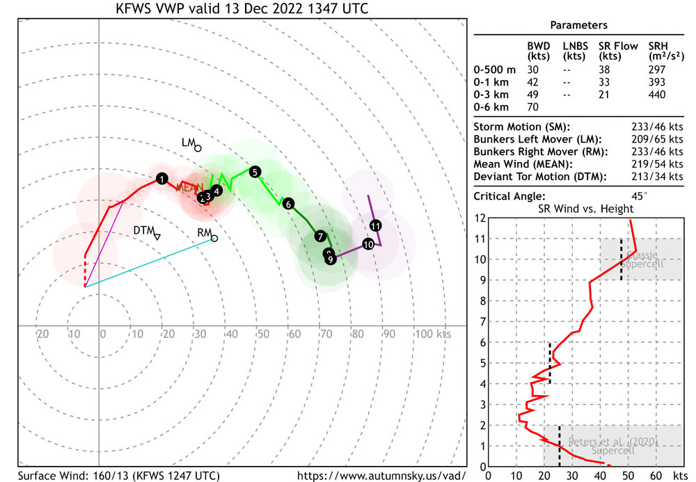
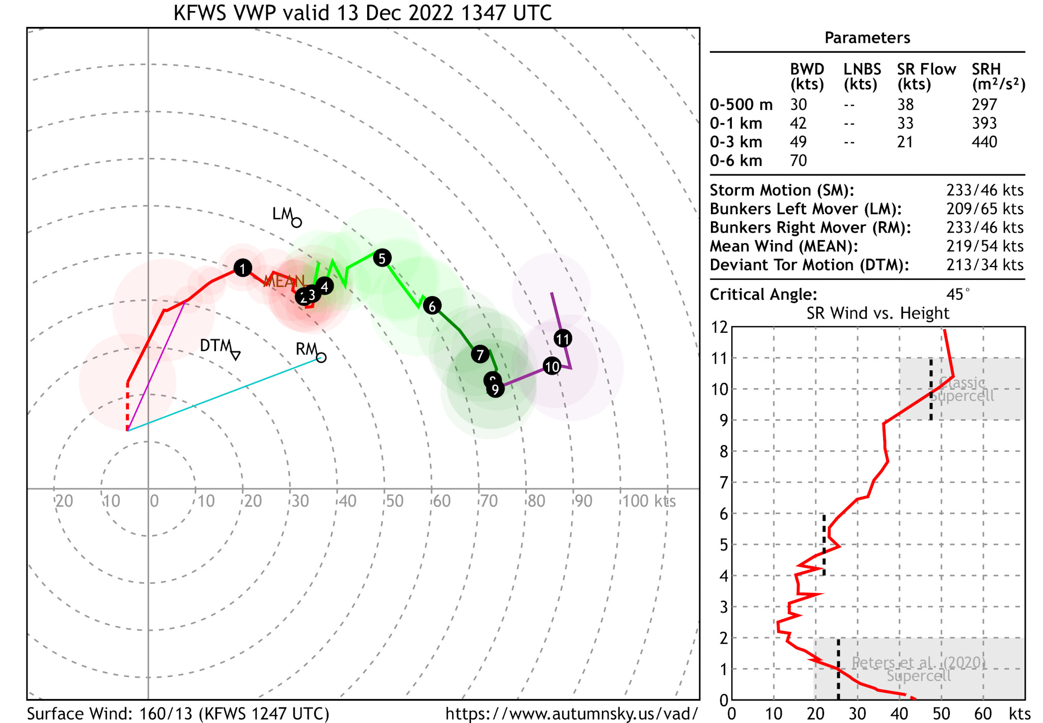
Here’s a look at the Fort Worth area VWP earlier this morning around the time of tornadic circulations. 42 knots of 0-1km shear and nearly 400 m2/s2 0-1km SRH. Very favorable for tornadogenesis, given sufficient low level instability.
-
1
-
-
15 minutes ago, weatherextreme said:
If this system is producing during the early morning hours wondering what is going to happen come mid day/evening as it moves east. Towards the enhanced
Residual nocturnal low level jet contributed this morning with impressive boundary layer wind fields.
Typically you’d expect these threats to wane for a bit during the late morning, but we still have a 40-50 knot low level jet across eastern North Texas as of 15z, along with favorable 0-3km CAPE, enhanced vorticity and strong deep layer shear.
The tornado threat may never really ramp down, but I’d expect intensity and coverage of storms to spike by mid to late afternoon across East Texas. Open warm sector storms could become tornadic supercells and if some guidance is correct, we may see a potent scenario with the squall line breaking into a line of semi discrete supercells from East Texas into northwestern Louisiana
Even after dark the threat may only worsen, eastward across Louisiana. With relatively slow progression of the cold front, parts of Louisiana and Mississippi may see an “enhanced” threat of tornadoes tomorrow as well.
-
3
-
-
Forecasts show a robust trough sweeping across the Plains on Tuesday. More potent than the broader trough that accompanied the 11/29 moderate risk event in the same general area.
Wind fields look impressive. The GFS is rather aggressive with moisture return and instability surging northward into Arkansas. Most other guidance, including high resolution models and the ECMWF show a more confined area of favorable instability across east Texas into Louisiana.
It’s the cool season and with such wind fields, you don’t need much instability for trouble. Definitely a high shear/low CAPE setup.
The main question to me is, are isolated storms able to form ahead of the expected QLCS? Lapse rates are not nearly as impressive as 11/29, so this looks like mainly a wind and tornado threat. Less capping, but a potentially narrower warm sector, especially if high resolution guidance is correct.
Some key details need to be ironed out, but Tuesday definitely bears watching. Not sold on Tuesday AM pre-dawn severe, due to a stable near-surface layer, but who knows. (North Texas/southern Oklahoma)
I’m also mildly intrigued by a *possible* cold core setup over Kansas. Maybe it’s too late in the season, but steep lapse rates and strong wind fields suggest a non-zero severe risk could evolve closer to the surface low in Kansas.
In December, we chase?
-
3
-
-
18z SHV (Shreveport) sounding sampled 8.4 C/km mid-level lapse rates. Not only high end, but exceeds the observed maximum for late November:
-
3
-
Severe Weather 3-23-23 through 3-26-23
in Central/Western States
Posted
Terrifying.