

Quincy
-
Posts
6,151 -
Joined
-
Last visited
Content Type
Profiles
Blogs
Forums
American Weather
Media Demo
Store
Gallery
Posts posted by Quincy
-
-
An interesting setup tomorrow with several nuances that make for a difficult forecast. I doubt we will have high confidence on details until at least mid to late morning. The synoptic setup shares some DISTANT similarities to the 6/16 - 6/17/2014 sequence. I am not calling for the same evolution, but I do recall the Pilger day and similar surface features. The difference here is that we're a few weeks earlier in the season and the moisture field may be somewhat fragmented, resulting in more capping and delayed initiation. Interestingly enough, 6/17/2014 was a late initiation day in the same general area (northeastern Nebraska), with storms not firing until only a couple of hours before sunset.
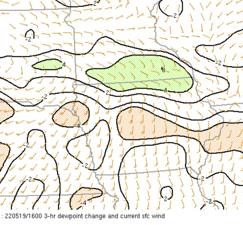
Anyway, I attempted to roughly illustrate the current mean HREF surface map features, effective 21z/4 PM Sunday. The area to watch is likely the triple point, somewhere in central/south-central Nebraska. I wouldn't say it's a true front, but it appears as if a surface trough will drape south from an area of low pressure over eastern North Dakota, toward a low near the Kansas/Nebraska border. A dryline will probably intersect the low at an effective triple point. Low-level moisture fields appear to be fragmented, as a moisture gradient may exist, displaced slightly to the east, over Iowa. There, strong capping will likely preclude convective initiation prior to loss of daytime heating. Storms could fire along the trough (both across eastern Nebraska and farther west toward the High Plains), but it seems as if the best shot an initiation, perhaps only 1-3 hours prior to sunset, would be near the triple point.
We could see early day storms also bring a hail risk to the Upper Midwest and might there be some warm front action across Minnesota/Wisconsin as well? Maybe even attempts at convective initiation along the trough over the eastern Dakotas?
Definitely an odd, complex setup. Some models struggle to convect prior to 00z. If initiation is too soon, there may not be adequate boundary layer moisture recovery across Nebraska. The sweet spot seems to be somewhere over the eastern half of Nebraska, around 6-9 PM, assuming that the cap is breached and storms can form near/ahead of the triple point. If storms were to fire on the northwest side of the trough/low, they will be displaced from better moisture/wind fields in the lower levels.
-
 3
3
-
-
-
4 hours ago, MNstorms said:
Also what is the difference between large and giant hail?

Large hail = 1” or larger in diameter
Very large hail = 2” or larger
Giant hail = 4” or larger
-
Chased western South Dakota today. Convergence on the north side of the Black Hills helped a high based supercell form, but storms very quickly became outflow dominant and clustered.
Had a neat sunset, at least. Convective initiation may be more widespread tomorrow with stronger forcing and somewhat better moisture. Still, most CAMs snow linear segments and bowing structures, despite seemingly (supercell) favorable wind profiles. It seems like another day to hang around the Black Hills, OR head south and hope for something to stay somewhat more discrete and tap into better moisture down in Nebraska.-
1
-
 1
1
-
-
Looks like Sunday-Monday have noteworthy severe potential, somewhere between the Central Plains and Upper Midwest. We could see the threat linger into Tuesday, before troughing ejects toward the Ohio Valley. Just in time to close out May.
-
1
-
-
Meanwhile here in Oklahoma City our temperature during daylight hours didn’t get above 56F today. Pretty absurd. Average low is 61F. (We did have a midnight high of 59, to get technical)
-
 2
2
-
-
Did not see the tornado, but was able to photograph the supercell from the south, long after the tornado dissipated. Lots of dust.
-
1
-
-
An upper level trough, slowly moving across the Central U.S., should bring a threat of severe thunderstorms across the Southern Plains through tomorrow. The Texas Gulf Coast and parts of Arkansas/Louisiana could be affected on Wednesday, before the pattern becomes unfavorable for severe thunderstorm activity for a couple of days.
A more traditionally favored severe pattern should then setup for the weekend, through the final days of May. Ensemble guidance is in good agreement with broad troughing across the West and some ridging across the eastern half of the U.S.. While some limitations will likely prevent this stretch from being higher-end on a broad scale, isolated to scattered severe thunderstorms seem probable between about May 28-31. From a storm chasing perspective, sometimes broad troughing is preferred as you get later into spring, as storm motion can be a bit slower and mesoscale features dictate the precise placements of threats.
-
1
-
-
1 hour ago, josh_4184 said:
Yea I realize that we don't see many storms to this magnitude, but I do feel like NWS and SPC kind of played it to conservative with their headlines and messaging prior to the storms firing ahead of the cold front.
I don’t know about that, re: SPC. Their outlooks are probabilistic. Although the parameter space was high, the model guidance was not showing a tornado outbreak. Since there was one lone tornadic supercell, well within their 5% outlook area, I’d say they did a fine job.
It’s easy to criticize in hindsight. The problem with these setups is a lot of times, nothing happens. Sometimes you get one intense storm and even more rarely, maybe you get an “unexpected” outbreak.
I was watching that storm a short time before it produced a tornado and yeah, it looked like it was rapidly organizing (increased lightning production, better radar presentation, etc.) but if you jump too quickly and always call for the worst outcome, you’re going to desensitize. The storm also looked like elevated junk when it first came ashore, but once it started ingesting surface-based instability and interacted with terrain, then it rapidly intensified
Were the watches and warnings perfect? No. They rarely are.
-
Glad I didn’t second guess my decision to chase up north the past few days. Just not sure if there’s going to be anything worth chasing tomorrow.
-
6 minutes ago, Hoosier said:
The special 19z sounding from APX was fairly veered in the low levels, but it possessed excellent speed shear. And despite lacking better directional shear, the overall CAPE/shear combo was potentially supportive of a significant tornado, which it appears we may have had.
Despite the somewhat veered 10m wind ob, there was a sickle shaped low-level hodograph (232 m2/s2 0-1km SRH) with 29 knots of 0-1km shear. Easily supportive, as you mentioned.
-
1
-
-
Couldn’t quite catch back to to the tornado that hit Gaylord. I was in Mancelona when the supercell was wrapping up and becoming rooted near the surface. Traffic, curvy roads and deep woods proved detrimental. Hope everyone is okay, that was an impressive radar signature, especially for so far north.
-
5
-
1
-
-
Parameter space is pretty high end looking across Michigan tomorrow, but residual capping and no obvious forcing mechanism ahead of the cold front suggest any threat is conditional, at best. A few CAMs hint at storm development in northern Lower Michigan, but I think that’s pretty lousy terrain for storm chasing.
-
Current storms look to be just north of the warm front. Large hodographs, but better low level thermodynamics are close to the IA/MN border.
-
Even though moisture is mixing out across parts of Iowa, moisture pooling along the warm front should allow for a narrow corridor of favorable low-level moisture. Most prominently in southeastern Minnesota. Keep in mind that the warm front will probably still nudge slightly farther north.
Storm motion should allow for any discrete cells to stay near the warm front, at least early in the convective cycle. Given the orientation of the moisture, parallel to expected storm motion, there could be a scenario where one or two supercells can persist for a couple of hours, before storm interactions and/or nocturnal stabilization kicks in.

-
SPC maintains hail/wind-driven enhanced risk for northeastern Iowa into southeastern Minnesota and west-central Wisconsin. They did bump tornado probabilities back down to 5%.
With that said, morning trends are favorable if you want severe thunderstorms. CAMs show less early day convection disrupting the environment near a warm front in southern Minnesota. 14z observations show dew points already in the mid to upper 60s across southwestern Iowa. SPC mentioned possible moisture field disruptions from an MCV over Missouri, but it looks like moisture recovery is well underway.
Confidence is highest in convective initiation by mid to late afternoon around south-central/southeastern Minnesota. Initial storm mode should be discrete or at least semi-discrete. Storms that track near the warm front, especially as the low level jet strengthens this evening, may pose the greatest tornado threat.
-
The main thing that worries me is a series of perturbations that swing through the Upper Midwest around late morning/midday. That could overturn the environment and disrupt return moisture flow. Hence why some CAMs only manage to initiate 1-2 storms right before 00z.
With that said, the model, ensemble and analog consensus continues to show a potentially volatile environment along the warm front near MSP toward southwestern Wisconsin by peak heating. There are even some signs that a broad area of conditionally favorable instability/shear could evolve over much of Iowa and southern Minnesota across the warm sector by 00z. This is why some CAMs are rather aggressive with a broken line of supercells erupting by early evening near the IA/MN border.
-
Today looks interesting across Minnesota, but I’m not sure that the moisture and wind profiles will support anything more than brief/transient supercells. Upper level support is there, but some veering low level flow will likely limit SRH. CAMs show a broken line of marginally organized storms, which seems realistic given the environment.
Thursday has bigger potential. SPC is playing it a bit conservatively for now. The CIPS analogs show a very strong signal for severe thunderstorms around the northern Iowa/southern Minnesota area, which lines up with the jet axis and expected warm front placement.
-
A pair of intense bow echoes are moving across central/eastern Kansas tonight. There have already been several measured wind gusts to 75+ MPH.
-
Just barely squeaked out 90F at DFW today, but it counts. The streak probably won’t break until Saturday, but there is a strong signal for a cold frontal passage this weekend, which could make it as far south as the Gulf Coast.
-
As we approach the climatological peak of the severe weather season, the threats for severe storms should continue in various forms through the balance of this week.
Tuesday: The fringe of enhanced northwest flow across the Missouri Valley/Midwest may glance appreciable instability across the Central Plains vicinity. Scattered to numerous strong thunderstorms are anticipated, along with at least isolated severe thunderstorm activity.
Wednesday: As the upper level flow pattern resets, a belt of enhanced winds should eject from the Northern Rockies toward the central/northern Plains. Only modest instability is expected across the northern tier, as well as over the High Plains. Regardless, a few strong to severe storms appear possible in both regimes. While somewhat greater instability becomes displaced to the east, a more appreciable severe threat may evolve across the eastern fringes of this sub-forum, before moving towards the Ohio/Tennessee valleys.
Thursday/Friday: A more expansive and potentially active severe weather setup could evolve across the Central U.S.. Details may still change, but seasonably strong upper levels winds are progged to eject from the Rockies across the plains and toward the Great Lakes/Ohio Valley by the start of the weekend. While the trajectory of the ejection is not classic for mid/late May, (trough appears more elongated and progressive) it should spawn at least scattered severe thunderstorm activity.
Beyond Friday, there are signs of another pattern reset, which could result in a few days of less active than usual conditions, from this weekend into early next week.
-
CAMs have been struggling with the MCS this morning. Trends look to be a bit more robust and somewhat farther SW. It looks like the convection will move toward the KS/MO/OK border area. Still think some isolated supercell development is possible on its southwest flank over eastern Oklahoma, but keep an eye to see any outflow shunts the threat farther S/SW. (not as far as OKC though)
Edit: Now that l look, the NSSL that was posted above seems to be the closest to current obs. That model shows more of a supercell threat down near I-40 and into southeastern Oklahoma. Seems to line up with trends, also considering the system will likely accelerate faster than progged.
-
PDS severe thunderstorm watch for southeastern South Dakota and vicinity says wind gusts up to 105 mph are possible.
-
Day 1 wind-driven moderate risk issued today for parts of the eastern Dakotas and western Minnesota. Based on wind profiles and model simulations, looks like storm mode will go linear very fast. This definitely has the feel of a summer setup, but it should help usher in somewhat cooler temperatures for the north-central states.
-
1
-
Late May Severe Weather Threats
in Central/Western States
Posted
Challenging storm chasing today and tomorrow, despite higher than average tornado probabilities. Today looks to be a close call with convective initiation prior to sunset in Nebraska.
Do you drift west and hope for storms coming off the High Plains? Wander north into eastern South Dakota and hope storms can mature, despite weaknesses in the wind fields? Or hang in northeastern Nebraska until time runs out? Definitely reminds me of 6/17/14 in terms of timing. I don’t think storms became established until after 00z. First tornado reports were shortly after 01z.
Tomorrow appears to have three plays:
1. Chase the SPC/parameter space bullseye near the MN/Dakotas border. Race east across MN with tornadic supercells likely, but storm motions will be fast and storms may ultimately form an MCS.
2. Play farther south, near the NE/IA border. Storm motion will be more W to E. Question will be how many sustained cells will persist into Iowa? IA has a bad rap for storm chasing. Seems to bust most of the time, but goes bonkers once in a while.
3. Kansas. The not-so-classic Kansas chase setup. Does a storm or two become established? Could play up near I-70 or even go for a Hail Mary down by the Oklahoma border.
Good luck to all chasers!