

Quincy
-
Posts
6,220 -
Joined
-
Last visited
Content Type
Profiles
Blogs
Forums
American Weather
Media Demo
Store
Gallery
Everything posted by Quincy
-

From the album: Spring/Summer 2015
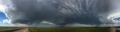
A shelf cloud looms across open fields in northern Missouri, ahead of a line of weakening thunderstorms. June 21st, 2015. -
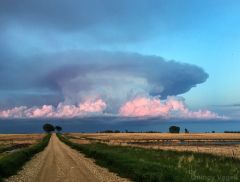
From the album: Spring/Summer 2015
Three rotating thunderstorms can be identified in this panoramic photograph. -

From the album: Spring/Summer 2015
Mammatus clouds fall behind shades of yellow and green wheat. -
From the album: Spring/Summer 2015
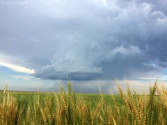
A low precipitation (LP) updraft is developing, but struggles to gain height in the atmosphere. This storm was weakly rotating, but began to dissipate shortly after the time of this photograph. -

From the album: Spring/Summer 2015
Mammatus clouds overlook a weakly rotating LP updraft in the distance. -
From the album: Spring/Summer 2015
This towering thunderstorm was beginning to get out of focal range for the camera, as the tops are missing from this photograph. -
From the album: Spring/Summer 2015
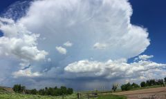
This thunderstorm, which developed very rapidly, begins to drop rain onto the Colorado countryside. -

From the album: Spring/Summer 2015
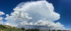
A thunderstorm, aided by atmospheric instability, explodes into the air over rural north-central Nebraska. June 6th, 2015. -

From the album: Spring/Summer 2015
A pair of funnel clouds reach down into the sky just north of Hartville, WY. June 3rd, 2015. -
From the album: Spring/Summer 2015
A thunderstorm, not severe, slowly begins to fade away into the sunset. Photo taken from near Monango, ND. June 2nd, 2015. -

From the album: Spring/Summer 2015
A supercell thunderstorm begins to form over Cambridge, NE. May 15th, 2015. -
There is the potential for a regional severe weather event on June 22nd. The threat zone extends from portions of the middle/upper Mississippi Valley into the western Great Lakes. All severe weather hazards are possible and given the nature of the setup, forecast trends are being closely monitored. As at least two pieces of shortwave energy rotate from the upper Midwest into the Great Lakes on Monday, a surface low is forecast to deepen from Iowa/Minnesota into Wisconsin. Impressive wind fields for this time of the year will combine with strong instability to create an environment favorable for severe weather. As it stands right now, two rounds of storms are expected. The first round would most likely be in the form of a mesoscale convective system (MCS) Monday morning, moving into the Great Lakes by midday and early afternoon. The second round develops in the wake of this activity, at and shortly after peak heating, later in the afternoon. The setup is a bit complicated and there are reasons to believe that two rounds of mixed intensity are favored over one robust atmospheric punch. The MCS during the first half of the day could pose a threat for primarily damaging winds and isolated hail. Once that system moves out, there should be modest air-mass recovery. The issue is that wind fields in the lower levels begin to veer, causing a more unidirectional shear pattern. This will likely dampen the tornado potential somewhat. Nonetheless, even forecasts on the more conservative end of the spectrum indicate a setup favorable for at least a few tornadoes. The afternoon to early evening threat may feature fairly widespread damaging winds, if storms were to merge into a linear system. Supercells still appear probable and they may extend into the early evening. However, for the reasons listed above, this does not look like an ideal setup for a major severe weather outbreak. Trends for this event tend to move the surface low a bit quicker, which also speeds up the veering of winds. The best wind fields may also become somewhat displaced to the northeast of stronger instability to the south. The Euro has joined the GFS/NAM in developing strong instability, as earlier it was showing a less unstable setup. The RGEM is also on-board and all of the models are in general agreement in terms of timing and geographic placement. Wisconsin is the target for the initial MCS on Monday. That system should weaken as it moves into portions of upper and lower Michigan. Later in the day, the target becomes southern Wisconsin and northern Illinois. Portions of lower Michigan and northwestern Indiana may also get in on some action. Damaging winds should be the predominant threat. The stronger cores can produce large hail and a few tornadoes seem probable. At least one of the following scenarios would need to occur to more fully maximize the tornado threat: First, outflow from the morning MCS could work to set up one or more boundaries to locally enhance a tornado threat. If the MCS decays faster than projected, that could lead to less disruption of the wind field and even stronger instability. A mesoscale low and/or a main low tracking further south into southern Wisconsin (instead of northern sections) may maintain more backing in the lower level wind fields through the threat zone. It should be noted that even with the projected wind fields, at least a few tornadoes remain likely. Given both a strong low level jet and 0-6km shear in excess of 50 knots, there is at least some potential for strong tornadoes. All of the factors currently forecast likely place Monday into more of a mid-range (SPC moderate risk) severe weather threat, as opposed to a higher-end (SPC high risk) outbreak. Stay tuned to later forecasts to see how the forecast setup evolves. The NAM forecast below for 21z Monday shows winds veering substantially across Wisconsin and Illinois:
-
A severe thunderstorm threat is expected to develop late this afternoon into the evening hours across portions of the northern Plains. The setup includes an area of surface low pressure ejecting from Wyoming toward the Nebraska/South Dakota border late today. At the same time or shortly thereafter, an embedded upper level shortwave swing through the Dakotas. The combination of kinematic support and strong instability will likely result in several severe thunderstorms with all severe weather hazards possible. The severe weather threat may continue well into the night as storms shift east-southeastward. The computer models are in good agreement with the synoptic setup and even most of the mesoscale details seem fairly clear. The HRRR/NAM/RAP show an area of low pressure moving into east-central Wyoming by late afternoon with isolated thunderstorm development across much of eastern Montana. The initial development is closer to the upper level forcing at the time and in association with a frontal boundary interacting with moderate instability and modest wind shear. Further east, although stronger surface heating/instability are progged, a fairly strong cap should limit convection for most of the afternoon. Between about 22z and 00z, surface heating looks sufficient to begin breaking the cap. At this time, robust thunderstorm development appears likely across southeastern Montana and far northeastern Wyoming. In the immediate downstream environment, a secondary warm front/differential heating boundary is showing up with the high resolution guidance. As it looks now, that should be draped roughly near the I-90 corridor from far northeastern Wyoming into the western half of South Dakota. It is here that strong instability and increasing wind fields should be very favorable for severe thunderstorms. Any discrete thunderstorms between 23z and 02z near this secondary boundary are expected to have the highest probability to produce tornadoes. The higher end instability scenarios appear overdone, but even the less dramatic GFS shows in excess of 2500 J/kg MLCAPE overlapped with 60 knots of bulk shear through much of western South Dakota. Given such instability, the initial threats appear to be large to very large hail, followed by isolated tornadoes. A more substantial damaging wind threat likely develops during the evening hours further east. As the low level jet really ramps up and upper level winds increase, the kinematic environment should support a significant MCS, possibly a derecho. The exact placement of this convective system develops on how and where thunderstorms grow upscale. It appears that beginning in northwestern and moving into central South Dakota is where the model consensus stood as of this morning. This is also supported by an intense inflow environment with moderate elevated instability and a vigorous low level jet (in excess of 50-60 knots) ejecting from northern Nebraska into portions of South Dakota. While the convection-allowing models differ slightly with solutions, they all show an elevated threat of fairly widespread damaging winds into early Saturday morning across much of South Dakota. This is a fairly interesting case, as this portion of the (western) northern High Plains does not have many significant tornado cases dating back to the early 1960s. One of the red flags for tornado development includes storm coverage as a result of capping. Nonetheless, regardless of geographic region, it is possible for a strong tornado to develop given the expected environment. If a strong tornado were to form, this would most likely be in western South Dakota or perhaps far southeastern Montana/far northeastern Wyoming. Compared with climatology, the projected severe weather parameters tonight fall into the high end of prior tornado cases for the region. Although wind fields intensify into the evening hours, a gradual loss of heating and a trend toward storm mergers may also mitigate the threat. The threat of most widespread impact will likely end up being damaging winds, even if a derecho does not form. For what it’s worth, the 09z SREF derecho probabilities are in excess of 50% for a large portion of South Dakota by 06z Saturday. A few severe thunderstorms are also possible across southern North Dakota and a rogue supercell cannot be ruled out in the Nebraska panhandle either.
-

Central/Western Medium-Long Range Discussion
Quincy replied to andyhb's topic in Central/Western States
I would still expect at least one or two decent severe weather events between Thursday, June 18th and Sunday, June 21st. The Euro/GFS aren't in the best agreement with specifics, but both advertise some high CAPE/modest shear environments. Of course, the best kinematic support will likely remain displaced to the north. Still, with sizable areas of 3000+ J/kg MLCAPE progged for at least some of the period and decent winds upstairs, it's worth keeping an eye on. Either way, as mentioned, nothing in the High Risk category should be expected. If anything, I'd suspect multiple SLGT/ENH risks in the period. The aerial coverage for such threats should remain on the smaller side, unless model guidance takes some sudden shift back into the "right" direction. -
As the calendar passes deeper into June, there is typically a steady drop-off in the frequency of severe weather threats across the U.S. Last year featured a grand finale to the severe weather season with a fairly significant sequence or tornado events across portions of the north-central U.S. from June 16th to 18th. While this year will likely not see quite an intense show as June 2014, there could very well still be some respectable severe activity with tornadoes. Mid-June of this year has been on the radar, so to speak, for quite some time. While there are still some model differences, it would appear that at least a couple of days between Thursday, June 18th and Sunday, June 21st should feature at least localized severe weather events. Note that there is some isolated potential before June 18th, this article will focus more so on the 18th onward. With it only being the 15th and plenty of time for forecasts to change, it is too soon to get into specifics. There are at least two main ingredients that would appear to favor severe weather, more-so, perhaps, than the U.S. has seen over the past week or so. Strong to possibly extreme instability is projected to be in place. Both the GFS and Euro show sizable areas of of 3000+ J/kg MLCAPE. The upper level flow is shifting toward a more zonal pattern, at least in the larger scale. An increasingly tight height gradient is likely from the central/northern Plains into portions of the Midwest by the end of the week and into the weekend. This is expected to result in a stronger component to the winds in the upper levels. The result is favorable forcing aloft and enhanced wind shear with any shortwave energy that ejects through. There are always caveats and red flags. While there may be more severe weather ingredients to work with, the overlap of those parameters may be relatively small. For example, while 500mb flow may be in excess of 50 knots for a time during this period, the best instability will almost certainly remain displaced well to the south and east. This in itself should tend to favor a more localized severe weather risk. Nonetheless, the Euro and especially the GFS progs over the past several runs highlight(ed) the period in and around June 18th to 21st. The potential exists for severe weather, possibly significant, including tornadoes somewhere in the region between the northern half of the Plains to the western Great Lakes. At the very least, some high CAPE/low shear setups are likely. The questions will become, how large can the threat zones extend and will some of the more impressive shear overlap with stronger instability? Take a look at some forecast soundings for this weekend if you want some severe weather eye candy. It is silly to take these progs too seriously at this point, so we will have to wait and see how the forecasts evolve. A broad geographical area is highlighted here and it will not be until the short-term that exact threat zones can be confidently identified. Nonetheless, at least one or two solid chasing days are predicted between Thursday and Sunday. If you are willing to travel or on a chasecation, there is reason to be cautiously optimistic about the storm chase potential coming up.
-
Central/Western Medium-Long Range Discussion
Quincy replied to andyhb's topic in Central/Western States
Still have eyes on this period. Verbatim, the 12/10 Euro shows bonafide threats days 8, 9 and 10. Would like to see more model consistency, especially once we get inside of 7 days. -
Central/Western Medium-Long Range Discussion
Quincy replied to andyhb's topic in Central/Western States
Details aside, there's at least some fair model support of some type of severe threat in the central/northern Plains to upper Midwest between June 16-20. The GFS, at varying degrees, has shown this threat in different capacities. Some runs showed a string of impressive days. The Euro has showed at least subtle signs, along with the ensembles. The latest Euro weeklies look a bit washed out in the mean, but the control run was a bit more dynamic up north. -
Recapping May: On the heels of a relatively active month for severe weather and tornadoes in April, May 2015 continued the pace. Although the month started slow with no tornadoes for the first two days and only a handful through the 5th, the greatest single day tornado event of 2015 occurred on May 6th. This was actually expected to be proceeded by a much more significant event on the 9th, but the former won out with 59 tornado reports, as the 9th did not fully live up to the hype/potential*. The first third of May paced at a somewhat above average count of tornadoes. Steady tornado events continued fairly regularly through the middle and latter portion of the month. Although there was no “defining” tornado outbreak after May 10th, there were multiple instances of picturesque tornadoes. While the previous forecast for May hinged on a near-average month, it looks like the period will end up at least slightly above average. The analog May of 1991 turned out to be the best fit among the four analogs from the 1990s. It was also the most active one of those four. The very persistent troughing across the Inter-mountain West to High Plains was well-indicated in both the forecast ensembles and analog data. Long-range forecasts may not always work out that well, but in this case, the verification speaks for itself. Only four days in the month reported no tornadoes, 5/1, 5/2, 5/12 and 5/31**, which includes an 18-day streak of reported tornadoes from the 13th to 30th. To quickly touch on the Plains long-term drought, it has been reduced significantly. Consistent bouts of heavy rain and convective activity have eliminated most of the drought area in the central to southern Plains. It now covers just a fraction of an area that it had before. In terms of tornado activity, the moisture transport northward has boosted the storm potential, but in a way, has also hampered the ability to easily storm chase. Without much EML (elevated mixed layer) influence this May and a tendency for storms to congeal into MCSs (mesoscale convective systems), countless tornadoes have been produced by high-precipitation supercells. Many of those tornadoes were rain-wrapped and/or difficult to see. Portions of Oklahoma reported a record-breaking 20 inches of more of rainfall in the month of May this year. A large portion of the southern Plains came in with precipitation anomalies of +8 inches or more for the month. That essentially means an extra two to three months worth of rain fell, if not more. This has caused major flooding in much of the region. June 1st through 10th: A general continuation of the recent pattern should continue through at least the first week of June. While the month begins with ridging across the southern Plains, the short-range models and global models alike are in strong forecast agreement with the upper level pattern. A trough is progged to dig into the West Coast with ripples of shortwave energy swinging into the central/northern Plains from June 1-3. Even though neither one of those three days appears particularly significant in terms of tornado potential, multiple severe reports, including tornadoes, should occur each day. After that, the parent trough is expected to continue digging and beyond that is where the forecast gets a little bit tricky. When looking back at the ensemble forecasts, the models had a ridge bias and did not really pick up on the trough becoming as amplified as it may. (For example, the most recent run, May 28th, of the Euro Weeklies looks much different for the second half of the first week of June, in comparison to the May 31st Euro ensemble run, which is more amplified) The trough could also become cutoff as some model projections indicate. The current expectation is that the trough axis may be just a little bit too far west to favor an outbreak-type severe setup in the Plains. With that said, whether the trough eventually ejects east to cause a significant event, or rather just a string of steady days (much like April and May of this year), there should be fairly consistent tornado threats through about the 7th or 8th of June. Rounding out the period, whatever is left of negative height anomalies in the West should relax to near climatology. Verdict: Somewhat above average tornado activity between June 1st and 10th. Fairly consistent bouts of severe weather, including tornadoes, are expected through the first week of June. Much like the previous six to eight weeks, while there may not be a higher-end severe setup on any particular day, tornado reports should be observed on most of these days. June 11th through 30th: Fighting with climatology and the computer model forecasts, there is only so long that relatively amplified troughing can dominate the pattern across the western half of the U.S. Starting with analog guidance, the results are fairly mixed. The general pattern assessed in the top four analogs (based off of GEFS 8-14 day prog from 00z 5/31 and extending out 20 days) is characterized as featuring ridging across the western U.S. to central/southern Plains and some troughing across the Great Lakes. It sounds a bit like what happened to start 2015. However, the individual four analogs (based on early June 2015 forecasts) diverge greatly in the period 10 to 20 days following. The 1991 analog, which was a strong match to May 2015, continues to show up. That June featured slightly below average tornado counts. Another analog that was also mentioned in the May 2015 tornado forecast is 1990. This one also shows up for the month of June and that particular month was well above average in terms of tornadoes. On the flip side, the other two analogs showed well below average tornado counts. The expected pattern to start June 2015 resembles late June 2006. That June finished fairly quiet and was followed up by one of the quietest months of July on record in terms of tornado activity. The final GEFS-based analog is 2002. That June was even quieter than 2006 and July of that year was also well below average for tornadoes. What can be made out of these mixed signals? Based on persistence and trends observed so far this spring, the computer forecast models have generally erred on the side of too much ridging occurring too quickly in a long-range forecast. It is inevitable that ridging will eventually prevail, but that does not entirely shut off the tornado season. In fact, it is very possible, if not probable, that troughing across the Great Lakes and/or Northeast could enhance the threat of severe weather from the Midwest into the Ohio Valley. A northwest flow regime tends to favor tornadoes in that region, especially the Ohio Valley. The expectation with this forecast is that mid-June should feature decent tornado potential, but that late June may not be as active. All four of the analogs above were eventually followed by a sharp drop-off in the tornado season, whether that came in late June or July. Also, one cannot forget June 16-18, 2014, in which an otherwise quiet tornado season become extremely active seemingly out of nowhere. Moisture return cannot be overlooked and this sets June 2015 apart from recent months of June. The soil moisture content across much of the Plains is much higher than it has been in at least two to three years. The period from May 1-29, 2015 featured slightly to somewhat above average soil moisture content from the Southwest into most of the Plains. This available moisture alone would tend to favor tornadoes, even if upper air and kinematic support are marginal. If the jet stream can stay active and provide enhanced flow aloft, a setup like mid-June 2014 could be possible sometime in June 2015. If such a setup did occur, available moisture would probably not be a concern at all. The bigger question becomes, can the Plains and Midwest eventually see more EML influence? That may be the difference between another “climo month,” versus a more memorable month for tornadoes. So far in 2015, it has been an active tornado season in two areas. One lies from north Texas/Red River Valley into central Oklahoma. The other is across the central to southern High Plains. Looking ahead to June 2015, early June features tornado prospects from the central/northern High Plains eastward into the Dakotas and Nebraska. Later in June, signs point toward Siouxland eastward through the Midwest and into portions of the lower Great Lakes/Ohio Valley. Verdict: Near to slightly average tornado activity between June 11th and 30th. June 1-10 forecast: Somewhat above average tornado counts in the U.S. June 11-20 forecast: Near average tornado counts in the U.S. June 21-30 forecast: Slightly below average tornado counts in the U.S. June 2015 tornado estimate: 255 tornadoes in the U.S. (slightly above average) *As has been the case many times this year, morning convective activity and MCS dominance have mitigated the frequency of discrete supercells. **This is subject to change as it may take a day or two for official reports to come in for May 31st.
-
Central/Western Medium-Long Range Discussion
Quincy replied to andyhb's topic in Central/Western States
The 00z Euro depiction of a modest trough moving into the Pacific Northwest to start June is supported by the EC ensembles. It's a ways out there, but verbatim would feature at least some severe potential from the central/northern Plains into the Upper Midwest. Worth watching I'd say in an otherwise increasingly meh pattern to finish May and prospects of stronger central US ridging deeper into June. -
Central/Western Medium-Long Range Discussion
Quincy replied to andyhb's topic in Central/Western States
The day 8-14 GEFS mean continues to look mildly interesting with at least modest western troughing. However, the new Euro weeklies are the kiss of death with a mega ridging building across the central US after June 6/7. I'm not sure how much stock I'll put into that projection, but something to watch in later ensemble runs. -
Central/Western Medium-Long Range Discussion
Quincy replied to andyhb's topic in Central/Western States
Euro weeklies should be out by 8pm eastern time M/Th on WxBell. -
The relatively active month of May looks to heat up again in the coming days. After a lot of severe thunderstorm activity last week, the first few days of this week have been on the quieter side. I am looking ahead to three days in particular for the next notable severe weather threats. Sleeper Thursday: This day has not been on the radar for most, but offers some potential, even if it is lower-end and in a relatively small area. I am focused on western Texas for isolated supercell/severe potential late Thursday afternoon into the evening hours. A small perturbation/vorticity lobe is modeled to pivot from eastern New Mexico into western Texas late Thursday. At the surface, modest daytime heating will likely result in an area of 1000-2000 J/kg SBCAPE, coupled with approximately 30 knots of 0-6km shear. Although the shear is somewhat marginal for supercell potential and the aerial extent of overlapping parameters is small, the higher resolution models do favor clusters of storms developing in this area. Some red flags include weaker winds aloft and storm mode/coverage, but an increasing low-level jet and backing winds around 00z may provide a small window for tornado development. What gets my attention about this event is that it is under the radar and in favorable chase terrain. I do not expect a lot of people to be out and the High Plains have featured several beautiful structure and tornado events this season, so I am not sure I can pass it up. Worst case, I would bail and head north, to get into closer position for Friday. Localized outbreak on Friday: The model guidance continues to show a strong signal for a severe weather on Friday, with an increased tornado potential across portions of the central Plains. Due to the models speeding up the system just a bit, more forcing and a favorably placed, developing surface low, Friday will probably feature the greatest potential in the otherwise multi-day threat. With the surface low moving into the central High Plains Friday afternoon, the models show strong instability developing across Kansas and Nebraska. The focus appears to be Nebraska, where multiple boundaries/fronts will locally enhance a tornado threat. The warm front is an obvious focus point, as it lifts through Nebraska late in the day. Moving toward late afternoon, the 4km NAM fires a line of discrete storms along a dryline, which will advance eastward through Nebraska and adjacent Kansas ahead of the developing surface low. Look for severe storms along this line, with an isolated to scattered tornado threat. This may extend as far south as sections of north-central Kansas. Along the warm front, the focus narrows in closer to the surface low and warm front/dryline intersection. I would watch the first or second cell closest to that point for a tornado threat. Aside from at least 2000-3000 J/kg SBCAPE (NAM is more like 3000-4000 J/kg), 35-45 knots of 0-6km shear (a bit higher via NAM) and favorable forcing for ascent all favor this severe threat. I imagine that the threat level will be upgraded to Moderate Risk by the Storm Prediction Center (SPC). What makes the threat here a bit more robust than some previous days is that we are not seeing a strong signal of convective debris or MCS activity overturning the atmosphere prior to peak heat. If there should be any convection in the morning, it would likely be limited in coverage, and outflow from that activity may only serve to further enhance the threat by leaving additional boundaries in place. Another quick note is that depending on how wrapped up the surface low becomes, the threat may punch northward into southern portions of South Dakota, especially into Friday evening. It is hard to really outline any significant red flags for Friday. There is the question of storm coverage, but a higher-end event in this case is actually favored when storms are more isolated. Precipitable water values are also expected to be lower than some recent events, so that further mitigated an MCS threat. I suppose there could be storm mergers and some messy storm mode eventually, but all in all, I think this is a bonafide threat and certainly a day to get out and chase. Messy mayhem on Saturday: The setup, overall, has a lot of similarities to last Saturday. It is likely that some junk convection and MCS activity in the morning will mitigate the threat. Also, the mid to upper level flow looks rather southerly, which is not ideal, as forecast soundings show veer-back-veer issues. With that said, if there are pockets of moderate instability, as the models indicate, there should still be corridors of an enhanced severe threat. This includes tornadoes, as 0-6km shear looks to be at least 40-50 knots and probably higher across some western areas of the threat zone. The red flags win out here, but there is time for this to change. In terms of chase potential, it will take some patience and strategy. Even last Saturday did result in clusters of tornadoes. With this threat being furthest out and potentially disappointing, I will not spend too much time focusing on it at this point. Of course, trends will be monitored and the threat will continued to be monitored.
-
Central/Western Medium-Long Range Discussion
Quincy replied to andyhb's topic in Central/Western States
One thing I've noticed too, is that in the long range, particularly >15 days out, the ensembles have consistently "changed" the pattern too quick. First we were supposed to get into ridging in the East in April. Eventually it did happen, but it kept getting pushed back. Now we're been seeing this "death ridge" keep getting pushed back further and further. Question is, when does the pattern give away to climo? We won't see these deep troughs in the West last forever. It looks like most, if not all of the rest of May holds potential with the overall, larger-scale pattern. -
Central/Western Medium-Long Range Discussion
Quincy replied to andyhb's topic in Central/Western States
If the lower analog domain is used for Saturday, it shows one of those high-end matches that we saw last week. Either way, a consistent signal of significant potential, if the red flags and limiting factors don't win out. -
Central/Western Medium-Long Range Discussion
Quincy replied to andyhb's topic in Central/Western States
A nicely active May pattern for sure. One that we haven't seen the likes of in at least a few years. The 1991 analog isn't working out too bad at all. I'm holding my breath about getting too amped up for a possible higher-end event, but it appears likely that anyone who doesn't mind a bit of traveling should have three solid chase days FRI-SUN. I like the challenge too. A lot learned from last week. Shifting targets. Evening surprises. Etc. Keeps it interesting and forces more use of meteorology skills than just relying on "modelology".