OHweather
-
Posts
5,046 -
Joined
-
Last visited
Content Type
Profiles
Blogs
Forums
American Weather
Media Demo
Store
Gallery
Everything posted by OHweather
-
Looks like showers of graupel/snow have been fairly numerous over the last few hours. You're on the board for 2015-16 at least!
-
I'm sort of interested in Saturday night wherever the Huron connection sets up. Looks like a little shortwave moves through with a period of good moisture and extreme instability. 850mb temps of roughly -6C in a NW flow are sort of meh, but if the band can setup in the higher terrain of Geauga or (more likely) NW PA a 1-3" type accumulation wouldn't shock me by Sunday morning.
-
The recent NAM and GFS are looking better for a possible burst of lake effect precip Saturday night...but with 850mb temps of around -5C by that time and a northwest flow blowing lake modified inland and preventing a consolidated band from setting up, I still don't think there's any accums.
-
I don't think anything will stick right now. The airmass gets pretty dry by Friday night and through the weekend, and it's a short fetch. The airmass is also a bit warmer than the October 2013 event. So any showers could have some flakes mixed in Saturday or Saturday night, but the only chance at any accumulation would be in the higher terrain of NW PA if a Lake Huron band can establish itself...but even there I wouldn't expect much.
-
WITH THE COLD POOL ALOFT...LAKE EFFECT RAIN/SNOW SHOWERS WILL GET GOING FRIDAY INTO SATURDAY BEHIND THE FRONT WITH NORTHWEST FLOW OFF THE LAKE. NOT SURE HOW MUCH THOUGH WITH VERY DRY AIR IN PLACE ON SATURDAY AS HIGH PRESSURE FILLS IN BEHIND THE FRONT. AT THIS POINT...GIVEN THE DRIER AIRMASS...RESTRICTED THE COVERAGE TO THE AREAS IMMEDIATELY DOWNWIND OF THE LAKE.
-
Apparently those squirrels haven't seen recent runs of the CFS I'm a bit nervous about this winter...hopefully we can get some lake effect events even if we overall have a slow winter.
-
Some 4-5"+ amounts in Lake and Ashtabula Counties! Very impressive 1100 PM HEAVY RAIN CONNEAUT 41.93N 80.58W 09/12/2015 M5.45 INCH ASHTABULA OH MESONET 1100 PM HEAVY RAIN CONCORD 41.40N 81.85W 09/12/2015 M4.08 INCH LAKE OH MESONET 1100 PM HEAVY RAIN EASTLAKE 41.67N 81.42W 09/12/2015 M3.38 INCH LAKE OH MESONET 1100 PM HEAVY RAIN NORTHEAST OHIO APT. 41.78N 80.70W 09/12/2015 M2.68 INCH ASHTABULA OH ASOS 1100 PM HEAVY RAIN CLEVELAND HOPKINS AIRPO 41.41N 81.85W 09/12/2015 M2.76 INCH CUYAHOGA OH ASOS 1100 PM HEAVY RAIN ERIE AIRPORT 42.08N 80.18W 09/12/2015 M3.74 INCH ERIE PA ASOS It also appears that there were two cheap tornadoes in the Cleveland area this weekend; a brief touchdown near I-90 and Crocker around 5:30PM on Friday...there's video of a condensation on the ground with what appears to be some debris flying up of that tornado...and last night a little after 5:00PM a waterspout made landfall in Vermillion and caused minor roof and door damage to the cities maintenance garage. Hopefully the NWS makes them both official because there's strong evidence for both tornadoes being on the ground...the Vermillion waterspout/tornado even had a small radar signature, which is impressive for a waterspout that far from the radar site.
-
I saw one circulation just off shore near Bratenahl on radar, but nothing else that made it close to shore in Cuyahoga County.
-
Cuyahoga county getting a lot of rain now. There have been several small circulations on radar with the showers over the lake, and I have reason to suspect a waterspout may have moved onshore in Vermillion and based on a rumor of debris in the air and a store being damaged in Vermillion (I have no way of verifying the source). Edit: pictures of minor roof and door damage to a building in Vermillion
-
CLE ended up going with a flood advisory for Ashtabula County with some flooding reported in Conneaut. They said up to 2" fell in that band after 10AM this morning on top of what fell last night. The latest RAP runs are absolutely off the charts for this evening with strong omega, decreasing shear above 10k feet and the aforementioned high RH air and instability. We shall see what happens.
-
It still looks like we'll get a little trough to drop across the lake in a few hours. The NAM and RAP both have lake induced CAPE increasing to over 2000 J/KG by late this afternoon with humidity up to roughly 15,000 feet and well aligned winds up to about 10k feet. I'd have to think thunder/graupel and possibly waterspouts will accompany any activity later along with heavy rain. There's been a persistent lake effect band in northern Erie County PA into eastern Ashtabula County and the KHZY ASOS (or is it AWOS? not sure) suggests that radar is under-estimating rates beneath the band by at least half if not more. HZY has measured 2.12" of rain as of noon and that lake effect band is probably producing 0.25-0.75" per hour rates beneath it so there's probably a lot of ponding there.
-
The synoptic rain has done really well...a lot of areas should end up with near or over 1" of synoptic rain, with a heavy burst getting ready to push in now. There's been some modest lake enhancement evident since about midnight from western Cuyahoga northeast through northern Lake County, which is pretty typical for a NE wind...it's looking a bit better now. If I have time Saturday I may try to go up to the lake and watch for waterspouts.
-
Thanks! We may even get the ever elusive Huron connection too Saturday night into Sunday. A lot of the rain has been short lived storms recently which runs off and doesn't soak in well. My lawn was decently green 3 weeks ago but it's been dry since then.
-
Thanks! That's an interesting question regarding yearly liquid equivalents for LER vs LES. We definitely get more lake snow events each year than rain, but the rain events can produce more liquid equivalent easier due to the warmer atmosphere they occur in. This exact same event in winter could easily produce a widespread foot or two of snow but with only an inch of Liquid as opposed to potentially 2-3"+ of liquid. It looks like recent HRRR runs and the 6z NAM are slower and hence wetter with everything, so it'll be interesting to see how much liquid falls and if there's any flooding.
-
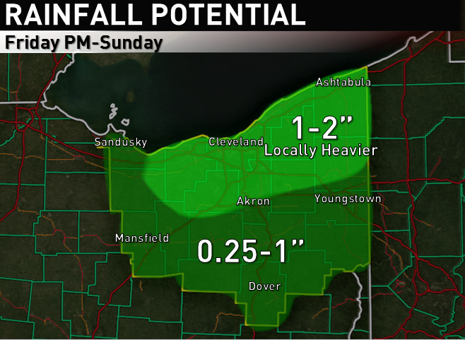
I'm pretty sure the lake enhanced/effect rain will deliver, and am actually worried it may deliver to the point where some flooding occurs this weekend. I'll be home this weekend and the Indians are playing the Tigers in Cleveland, so of course it will rain Pretty complicated forecast starting Friday afternoon in terms of when it will rain and how heavy it will be. A secondary cold front will move across NE Ohio early Friday afternoon with perhaps some widely scattered showers, and by evening some isentropic lift behind the front will overspread the area along with decent large scale ascent from a seasonably strong jet streak and positive vorticity advection overspreading the area. The 0z NAM has a nice surge of mid-level RH in this timeframe. This all should be enough to generate a period of synoptic rain Friday evening...however, the duration and intensity of the synoptic rain is uncertain. The hi-res NAM, Canadian, NMM and ARW for instance are sharper and slower with the trough and farther west with the surface low development Friday night into Saturday and have a 6-12 hour period of synoptic rain, while the standard 12km NAM and GFS are more progressive. The 12z Thursday Euro was slower than the 12km NAM and GFS but faster than the hi-res models and Canadian, and the 0z Euro which I just peaked at is a little slower and farther northwest with the synoptic rain. Given the trend overall over the last few model runs has been to slow everything down, and given the fact that closing off upper lows tend to progress slower than modelled, I'm going to conservatively lean towards the somewhat slower and farther west idea with synoptic rain Friday evening. I could see a general quarter inch of synoptic rain in the CLE area, maybe closer to 0.5" for CAK with maybe closer to an inch towards YNG. Even if the synoptic rain isn't heavy in CLE proper, with a NNE low level flow Friday evening, lake induced CAPE values of 500-1000 J/KG and good moisture, some lake enhancement of the rain is likely, which could push rain totals for the Friday afternoon-night timeframe to half an inch to an inch near the lake, with enhancement occurring on the west side too due to an easterly component to the winds. Shear is pretty bad above 5k feet Friday evening (but things do become better aligned later Friday night) which could keep things from getting out of control to an extent Friday night in the lake enhanced rain. Even the slower models pull the heavier synoptic rain east by Saturday morning, but the surface low tracking farther west and the upper trough closing off and moving east slower allows enough ambient moisture in the low to mid levels to hang back on Saturday for a more pure lake effect rain to continue. The GFS shows winds holding at NE through much of Saturday while the NAM has more due north winds that are somewhat better aligned...both models have lake to 850mb temp differentials of 15-18C during the day Saturday with limitless equilibrium levels. The GFS really dries things out for a while on Saturday while the NAM maintains better moisture...given the NAM is less progressive than the GFS and I'm leaning in that direction (if not even slower than the 12km NAM), I tend to think we'll stay moist enough on Saturday for lake effect to continue...I also think the winds will gradually back to a more northerly direction on Saturday. By Saturday evening the Euro, Canadian and some of the hi-res models close off the upper level trough pretty much over OH or just to our northeast (pay sites that have the Euro at a higher resolution and in more timesteps show it occurring) while the surface low tracks towards Lake Ontario. This is a nearly perfect evolution both aloft and at the surface for significant lake effect precipitation with a nearly due north wind. The 0z NAM develops an astounding thermodynamic profile Saturday evening with over 2000 J/KG of lake induced CAPE for several hours and well aligned winds below 10k feet. Most models slowly drop an inverted trough across Lake Erie Saturday night in a mainly north flow with an increase in moisture and as seen above unbelievable instability. The NAM and GFS are both a bit dry Saturday night, however the 0z Euro keeps 70% or higher RH at 700mb in place through 12z Sunday which would easily do the trick. The combination of a cyclonic flow...a surface trough...orographic lift in the N or NNW flow and extreme lake induced CAPE suggests that heavy rain is possible Saturday night in the primary and secondary belts. Conditions start to deteriorate for lake effect on Sunday as the low and trough begin moving east, but the winds will gradually turn more westerly and enough moisture and lake induced instability hangs around for light to moderate rain to continue much of the day in the Snowbelt. All told, between the shot of synoptic rain and some enhancement Friday night...off and on lake effect on Saturday...the potential for heavy lake effect Saturday night...and at least some lake effect continuing through much of Sunday...I don't see how areas within 20-30 miles of the lake from Lorain and Medina points east don't see at least 1" of rain from Friday PM through Sunday, and amounts of over 2-3" in several areas would not surprise me. 1-3" won't cause much flooding, but if it gets any higher there will be issues. That said, I was "lucky" enough to have the forecast earlier this evening for the website I help with and included this rain map for the weekend...in the text associated with the map I mentioned locally 3" or more of rain. Honestly after the 0z models came in slower with everything (which means more synoptic rain and better lake effect conditions hanging on for longer) I think this map may be conservative. If the hi-res models are right and we get 1-2" of synoptic rain Friday night, weekend totals could locally push 4-5" IMO! In addition to all the rain...although a northerly flow isn't ideal for waterspouts over the nearshore waters due to weaker convergence over the lake, the thermodynamic profile strongly supports waterspouts this weekend. Also, the NAM develops enough CAPE for small hail with any storms that roll in off the lake Saturday evening.

-
I was hoping there'd be some waterspouts near shore with the setup but the only report I saw of one was near Erie.
-
A couple of personal weather stations in Lake County between Mentor and Painesville around 0.5-0.6" of rain today...a station in Geneva at 0.80" thus far. Not a bad lake effect setup...hopefully it's just a warm-up for what happens come November.
-
Yeah, it has been really dry since roughly mid July. A lot of that July rain fell in the first half of the month. Hopefully the fall and winter feature near or above normal precip as we are pretty dry right now..:and even in a warm winter in Cleveland if you have a reasonable amount of precip some is bound to fall as snow.
-
Pretty decent setup for lake effect rain and maybe some waterspouts fairly close to shore starting tonight. It's getting closer to being that time of year again after a very rainy but otherwise fairly benign summer.
-
It seems like we've had just enough rain to keep things from really drying out, however I feel like the thunderstorms over the next few days will make or break us. Locations not impacted by the lake breeze stand to have a good shot at 85+ degree weather Friday-Sunday and possibly Monday too depending on the timing of any storms each day. Although there is a "chance" of storms Friday-Monday, the chances Friday-Sunday aren't particularly high at any one spot as there isn't really any forcing, so storms will be isolated to at best widely scattered each day. A few winners, a lot of losers. We'll see how Monday plays out...the current frontal timing of late Monday night isn't the best for a lot of storms, and the forcing with the front will probably be weakening as the upper low responsible for all of this opens up and moves NE. I think it's possible more than half the area is shut out of good rain out of this whole deal, which would probably get us to the point where we'd be included in the "abnormally dry" category on the national drought monitor.
-
I would say I hope the snow holds off till that Thursday so I'm home when it hits but at a certain point I have to give up the hope of coming home to a snowstorm...it'll only be my summer break by that point
-
Looks like all of the snow went into the west side, a lot of 2-4" reports out there. Probably because that's where all the open water is. And NW PA did ok looks like. We did get a heavy dusting in Athens even
-
CLE and LPR down to 1/2 mile visibility right now with solid coatings on traffic cams where the snow showers have been most persistent. Too bad this didn't happen overnight or else you'd all probably fluff out a half decent little accumulation.
-
The RAP is showing a pretty good layer of steep lapse rates and high RH through the DGZ and up to about 6-7k feet late this afternoon and this evening for a few hours as the trough evident just north of Detroit right now drops south across the lake. Lake induced CAPE gets to a little over 300 J/KG with equilibrium levels of 7-8k feet late this afternoon into this evening as well in this timeframe. There is a half decent band off of an icy Lake Huron with 850mb temps close to what should be over Lake Erie by this evening. I think the synoptic support and enough juice for some lake enhancement should be enough to get a half decent burst of snow showers after about 3PM through early evening, with light lake effect continuing into the overnight. Winds aren't particularly well aligned until after the trough passage but a little Lake Huron connection with a NNW to due N wind wouldn't shock me this evening. We'll see how well things accumulate but with a potential burst of snow as the sun angle starts getting lower towards the PM commute with some snow showers continuing into the night I could see 1-3" as far west as Erie/Huron Counties...less along the immediate shoreline (maybe half an inch to an inch at most). If you can get a little bit of snow down ratios this evening should be pretty decent with instability through the DGZ and cold surface temps. We'll see what transpires. As a note 850mb temps look colder than expected by a few degrees.
-
Yeah it's tough to tell, definitely some fog up there too. Great day!