OHweather
-
Posts
5,046 -
Joined
-
Last visited
Content Type
Profiles
Blogs
Forums
American Weather
Media Demo
Store
Gallery
Everything posted by OHweather
-
I've never seen that before...I've seen a winter storm warning include wind chill but not the other way around. Like I said, I think they were sort of "stuck" once the wind chill warning was issued last night starting at noon. I may be wrong but that's the impression I got. The AFD actually almost directly discussed almost everything I took issue with in my post at like 4AM...I'm glad someone there finally explained what's going on with the snow and wind in some forecast products, but don't agree with no snow/winter storm headlines being issued off the bat.
-
CLE did update their AFD at 11AM with much better reasoning and did hit the snow/blowing harder in the wind chill warning. I think by this point they were sort of bound by the wind chill warning issued last night without any winter weather advisories and didn't want to confuse people. I still stand by that a winter weather advisory or winter storm warning should have been issued for the snow, with wind chill warnings kicking in later, but it was nice to get a nice explanation and a mentioning of the snow/blowing in the wind chill warning...which wasn't initially done last night. It's actually up to 35F here. Hoping we get unstable enough for a really nice squall in a couple of hours.
-
Almost every traffic cam is just a wall of white in Cuyahoga County. Impressive squall.
-
Claridon in Geauga County already at 5.5" as of 11AM. The lakeshore counties will have 4-7" widespread by 1PM before any LES kicks in. Way too low on my forecast, but I still would've issued a warning.
-
If Trent already had 2" at 8AM I say no way he has less than 4" by 1PM. Intense squall line over the lake and decent snow showers continuing behind it all the way past Detroit.
-
CLE's AFD isn't out yet, so I probably won't read it unless it's out soon because even I am going to sleep shortly. However, I'm really eager to figure out their reasoning for what they just did with their headlines. They issued a winter storm warning for Ashtabula County and NW PA. I'm cool with that (they issued the warning until 7PM Sunday and the WSW "includes the wind chill" and didn't issue any wind chill headlines there, but I've heard that offices in general don't try to issue multiple headlines on top of each other, so I won't say anything about that). For the rest of NE Ohio, they issued a wind chill warning starting noon Saturday. Based on the wind chills, I'm also cool with that. However, they didn't issue any winter weather advisories or winter storm warnings for anywhere else. This makes no sense to me (again though, maybe they have some reasoning other than "advisory criteria is 4 inches so we 'can't' issue an advisory for 2-4 inches", that's what I will respectfully call not helpful to the public). They may try to say that the "wind chill warning involves the snow" (which would be the first time I've heard that), however the wind chill headlines kick in at noon. There's a chance the squall along the front that will likely cause extremely hazardous conditions will be completely through Cleveland and Akron by noon. The wind chill product also does not mention blowing snow or low visibilities, which will be the biggest issues (as mentioned earlier, 2-4" of snow on its own isn't a big deal). The snow and blowing snow could continue well into Saturday evening in orographic lift areas and also the band that will probably set up on the west side downwind of the crack in the ice there. Also, if they issued a winter storm warning for Ashtabula, they need to issue it for the rest of the Snowbelt. Due to the lack of higher terrain in much of Ashtabula County, amounts in Geauga County are almost always the same as or higher than amounts in Ashtabula County. The only exception is if a Huron band sits over Ashtabula County and doesn't move any farther west, or if a W-E type band just hugs the Ashtabula lakeshore. However, there is strong support for whatever Huron band develops moving into Lake/Geauga Counties. With ice on Lake Erie, terrain will be needed to ring out better lake effect snow. You have more terrain in far southern Lake County, Cuyahoga County and Geauga County (hell throw northern Medina in there too) than anywhere in Ashtabula County. This all suggests that if they issued a WSW for Ashtabula that they can extend it at least to Cuyahoga and Summit, if not even another row of counties west. Maybe I shouldn't sit here at 3:30AM picking apart the NWS headline decisions, but I'm really at a loss right now. After trying to reason it out bits of brain actually started oozing from my nose. Oh well.
-
Hopefully this link still works in the AM...Andre on Fox 8 showed a time lapse from the crib, definitely some movement of the ice and what appears to be an area of open water http://fox8.com/2015/02/13/brutal-cold-temps-begin-moving-in-tomorrow/
-
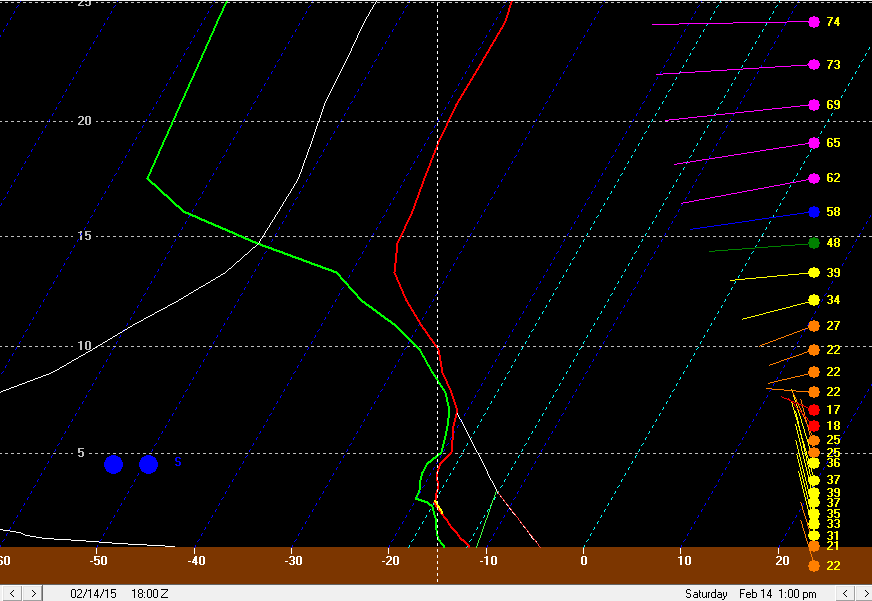
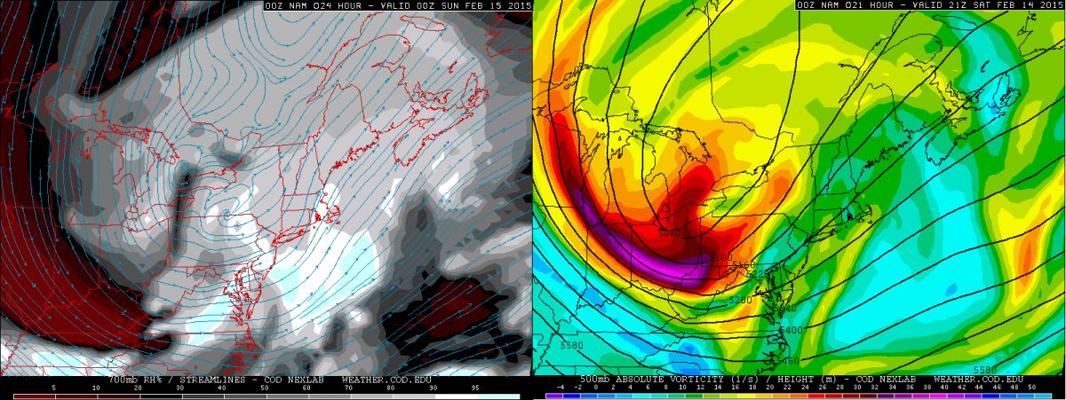
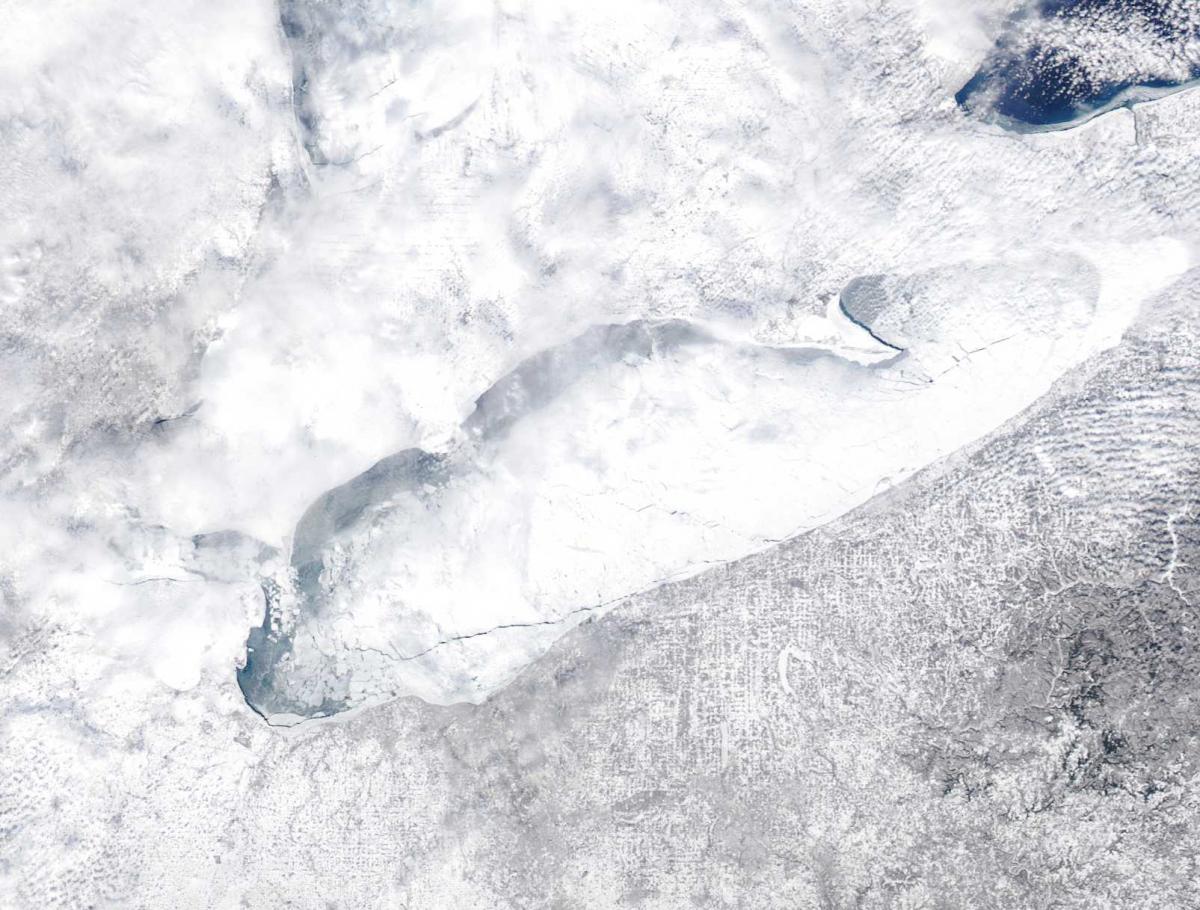
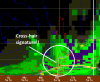
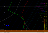
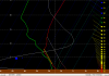
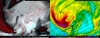
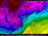
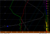
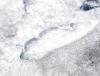
I was trying to be "sociable" while typing this (it is Friday night after all) so it took a while haha A tall +PNA ridge extending almost to the North Pole is helping facilitate a cross polar flow Friday afternoon, which is allowing frigid air to pour south towards the Great Lakes straight from the Arctic. A lobe of the polar vortex (currently over western Hudson Bay) will drop south through the Great Lakes on Saturday, causing a surface low pressure pictured over Lake Superior above to move southeast and intensify across the lower Lakes. This will cause some light to moderate synoptic snow along and ahead of a cold front that will drop across northern Ohio Saturday morning, and the deep arctic airmass behind the front will help cause some lake effect snow across northern Ohio. Ice on Lake Erie and upstream lake moisture will be critical to the lake effect forecast. For the remainder of tonight and into Saturday morning, a nice shot of upper level divergence in the left-front quadrant of an upper level jet streak combined with some half decent warm air advection on the nose of a strong mid-level jet will cause light snow across northern Ohio. There could be an inch or so of snow by 7AM Saturday as most models spit out around 0.1” or a little less of liquid precip. Ratios tonight should be 12-15:1 with most of the modest low to mid level lift focused in the DGZ. As we head into Saturday, low level convergence will really increase along and immediately ahead of the arctic frontal boundary, and falling mid-level temperatures will result in steepening low to mid level lapse rates and some surface based instability. This will lead to the snow becoming a little more snow showery after sunrise on Saturday, but the snow intensity will also increase. This will all culminate in a brief period (an hour or so) of blinding snow squalls along the arctic front late Saturday morning near Lake Erie and around noon or so farther inland. A look at synoptic model plots and forecast soundings in BUFKIT all suggest a very impressive snow squall potential along the arctic front: There will be a very impressive shot of positive vorticity advection early Saturday afternoon across northern Ohio (and much of the state really). This is a source of lift and can also help raise equilibrium levels and increase instability. In addition, low level frontogenesis and convergence will be very strong along the arctic front (both sources of lift). Note how at 850mb, there is a very sharp temperature gradient, and also note the sharp and sudden shift in wind direction and increase in wind speeds along and behind the arctic front. These are both sources of convergence and lift that can help an intense snow squall develop. As alluded to above, the frontogenesis values are fairly strong in the low levels along the arctic front as it drops across northern Ohio late Saturday morning and early afternoon. The layer of deep moisture and steep lapse rates along the front on forecast soundings is impressive due to falling mid-level temps and large scale lift acting to steepen lapse rates and raise inversion levels: Although the model does show a weak inversion limiting the model equilibrium level, the steep lapse rates and good moisture extend well above 10k feet in the atmosphere. If there is enough open water on Lake Erie to modify the airmass at all, equilibrium levels easily climb above 10k feet. This all suggests a heavy burst of snow. The snow along the arctic front will not only be intense, it will also be very high ratio, with large dendrites likely. Note how the omega (vertical velocity) in the red lines is very strong in the dendrite growth zone (the purple and yellow contours). This suggests that snowflakes will grow very effectively in any snow squalls along the arctic front. With strong omega up to about 17k feet, a flash or two of lightning in any squalls along the front wouldn’t shock me. Although the snow squalls along the arctic front will be short lived, totals by early afternoon from a combination of the light snow tonight into early Saturday, and the snow showers/likely squalls ahead of and along the arctic front will likely be 2-4”. The high ratio nature of the snow up through this point will improve the likelihood of these totals being realized. Forecast soundings show 30-40 knot winds along and behind the arctic front in the boundary layer, really just above the ground…cold air advection should help a large portion of that mix down in gusts, causing 30-40MPH wind gusts along/behind the arctic front…strongest near Lake Erie. Due to the high ratio nature of the snow, it will easily blow around. Blowing snow along/behind the arctic front will undoubtedly cause visibility issues and road condition issues. Although there were some cirrus clouds on Friday, we got a good MODIS shot of Lake Erie. There is a large crack in the ice east of the Lake Erie islands towards Lorain (very common), and also along the northern lakeshore. These cracks appear to be slushy, but could open up some with breezy SW winds late Friday night into early Saturday and strong NWrly winds Saturday afternoon behind the arctic front. There are a few smaller cracks farther east, including a pencil thin but long from all the way up the central and eastern lakeshore that may open some if the southwesterly winds into early Saturday enough. So, not a lot of moisture to be picked up off of Lake Erie, but definitely some. Immediately behind the arctic front, instability may briefly decrease for a time as surface temperatures crash a little quicker than the mid-level temps (above)…however, the mid-level temps will quickly recover. There’s still a fairly deep layer of steep lapse rates (that gets deeper again by mid to late afternoon) behind the front and high RH air to above 10K feet, so orographic lift could help ring out snow showers starting very quickly behind the front. By later afternoon, a very deep layer of steep lapse rates will return and good moisture will remain to above 5k feet. Winds will become very well aligned out of the northwest. This may help any lake effect/orographic lift snow showers increase late Saturday afternoon after perhaps a brief lull behind the front. Snow growth will really diminish by this point as the dendrite growth zone is confined to near the ground (much of the lift is just above the ground). This suggests that even as lake effect snow/orgraphic lift snow increases again later Saturday afternoon that it may not pile up as quickly. The increase in instability later Saturday afternoon will correspond to the vort-max (500mb vorticity on right) moving over Lake Erie and also an increase in mid-level moisture. This all suggests an uptick in lake effect/CAA advection type snow showers…the most concentrated snow will probably be over the higher terrain in the secondary and primary Snowbelts where orographic lift will improve the odds of snow showers developing. In addition, a surface trough may also drop across the lake Saturday evening, acting as another source of potential increase snow showers downwind of the lake. This surface trough passage does appear to correspond to another increase in low level omega as shown in the NAM overview image above (where I drew a circles and got excited over omega in the DGZ early Saturday afternoon). Lake effect conditions remain favorable through Saturday evening, so it’s not inconceivable that the vort max passage/mid-level moisture increase and surface trough passage all combine to allow half decent lake effect snow showers to continue through much of Saturday evening, especially in the higher terrain where the NWrly winds will cause good orographic lift. On the sounding above the winds appear to be sheared, but that’s more a product of the trough passing (winds become better aligned again later). The winds veering with height suggests low level convergence along the surface trough…winds over the lake will be closer to the mid-level winds (hence more northerly) due to less friction over the water/ice and slightly warmer temperatures (due to whatever heat flux occurs from the lake to atmosphere)…the warmer temperatures promote mixing of the more northerly winds aloft to the ground. Winds over land will be lighter and NW as opposed to N…convergence near the shore where the two meet. Later Saturday night, inversion heights and moisture depth decrease quickly, so lake effect should decrease to just flurries after midnight. An exception may be under any Lake Huron band after midnight where light to moderate but very fine snow could continue into early Sunday. As for snowfall amounts…2-4” synoptic for most. The lake effect is tough. The snowflakes will become very small and hence much lower ratio by late Saturday afternoon, so it will be hard to rack up good accums. The biggest crack in the ice is east of the Lake Erie islands, so to account for this I figured in 1-2” of fine lake effect snow as far west as parts of Lorain/Medina County to push totals to 3-5” here…could see a local 6” total on the west side if a band forms intensely enough before the dendritic growth becomes very low. Farther east, with better terrain and potential Lake Huron moisture, even with the lower ratio of the snow, I have to figure at least another 2-4” of lake effect snow in the higher terrain of the primary Snowbelt. Even though there’s ice on the lake, there’s a lot suggesting decent snow will continue well into Saturday evening, especially in the higher terrain…so I painted in 4-7” here. The only way there’s more is if the Lake Huron connection is better than I think. As for impacts…winds will gust 30-40MPH behind the arctic front into Saturday evening before gradually decreasing. The snow will become increasingly fine Saturday afternoon and evening, which when combined with the wind could cause significant visibility restrictions into Saturday evening before a gradual improvement occurs. The falling snow and likely extensive blowing snow will cause roads to be very slick from late Saturday morning when the arctic front drops through into Saturday night. Wind gusts and visibilities may arguably push blizzard conditions where lake effect sets up Saturday afternoon and evening, although it may be hard for many spots to actually verify 3 hours straight of 0.25 mile or less visibility and 35MPH wind gusts…but some places will be close. Map above. As I typed that I almost got worried I'd be a tad low in spots, we'll see. Should be fun, expecting a nice squall down here too
-
I'm working on a write up for my blog and will post it here when I get done in an hour or two. In the meantime, here's my map. Am concerned about locally higher amounts, but with ratios getting really low by later tomorrow afternoon I'm not sure the higher terrain can squeeze out more than 2-3" of very fine flake lake effect.
-
They actually have 5"+ as far west as KCLE and 8"+ for central Geauga eastward. I think their amounts are often ball park or even too high, but they have been very conservative with issuing winter headlines, especially this winter. I'm sure they have their reasons, but I really think this needs an advisory or even warning for the reasons I laid out above. Their snowfall amounts would at least suggest an advisory if not warning based on the blowing snow. I'm sure they'll issue something later tonight or tomorrow. http://www.erh.noaa.gov/btv/gis/images/CLE_Snow.png
-
Looking at MODIS imagery, those open areas do appear to be somewhat slushy. With breezy SW winds tonight into early tomorrow, and then strong and shifting winds tomorrow afternoon I do think some open water will reappear. There's a long but very thin W-E crack extending from north of Amherst east all the way up the eastern shore a few miles out. With the SW winds tonight and room for the ice to shift northeast thanks to the open water along the Canadian shore, it will very very interesting to see if that crack can widen. I'm fairly surprised there's no advisory from Cleveland. I think an area-wide 2-4" of snow is a good bet with another 1-2" at least from lake effect in the higher terrain. It's not the most snow, but there's a very good signal for a couple hours of very squally weather with the arctic front with blinding snow showers and 40MPH wind gusts, which by itself is almost enough for an advisory. Behind the front, with a very deep layer of steep lapse rates and good ambient moisture, any moisture from upstream lakes or from Lake Erie that makes it onshore and hits the terrain could cause continued squalls through a good portion of the afternoon with gusty winds. Even into tomorrow evening, moisture is still OK and there could be some orographic lift snows, and Lake Huron moisture could still drift as far west as parts of Lake and Geauga Counties tomorrow night. Flake size will be very small by later tomorrow due to the cold, but with the wind the fine flakes could cause very poor visibilities to continue in the higher terrain clear into tomorrow evening. I could honestly see areas from Lorain and Medina Counties points east (especially in the higher terrain) seeing hours (from late morning straight through the afternoon and potentially into the evening in a few spots) of visibilities below half a mile and gusty winds. Even if the higher terrain only gets 4-6" or so of snow, the prolonged potential for very poor conditions would honestly prompt me to issue a warning from Lorain and Medina east through the Snowbelt if I was sitting in that chair today and had that ability. But, I'm not, so I could be off base. At the very least an advisory seems prudent.
-
Hopefully we get a good MODIS shot this afternoon as there are just thin high clouds, so the lake should be pretty visible. Would be helpful. With a NW wind with high inversions and RH's behind the front, the lake effect would probably lead to blizzard conditions were the lake more open. As is it could still be fun for a few hours up there...and even down here looks squally with the arctic front. GOES imagery shows a bigger crack than yesterday, possibly due to the gusty NW winds yesterday, and there could be a little more shifting tonight into tomorrow.
-
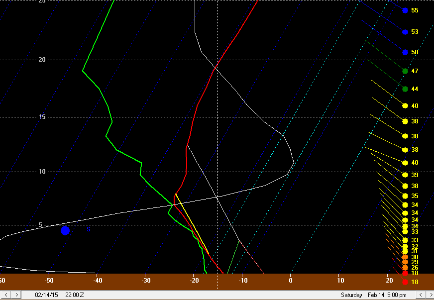
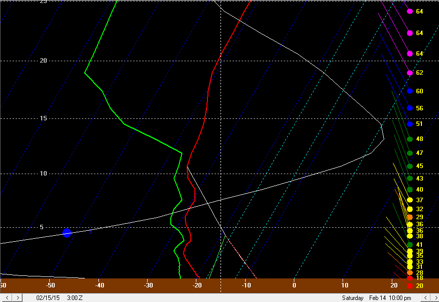
I think a few inches of snow is a pretty good bet. There's pretty good upper jet support and some isentropic lift in the WAA ahead of the cold front late Friday night into early Saturday, so that will probably result in a few hours of light to moderate synoptic snow to start the day Saturday, and that could be 1-3" for most areas. The potential appears to be decent for a snow squall along the arctic front around noon give or take on Saturday (regardless of lake influence). The NAM/GFS both advertise a deep layer of steep lapse rates along the front with a period of very strong omega in the DGZ. That could produce another inch or two in quick order. So, I think a lot of areas could see a 2-4" or so synoptic snowfall through Saturday morning. The lake effect is tougher. MODIS imagery from this afternoon confirmed what GOES visible imagery confirmed this morning, there is a crack just east of the islands and then along the northern shore that's maybe 10 miles wide, but elsewhere any cracks look small. So, moisture picked up off of the lake will probably be minimal. With strong north-northwesterly winds on Saturday the ice may move a little, but I doubt there's any more open water than today. Behind the front, the layer of steep lapse rates and moisture is fairly deep until Saturday evening, so I'd imagine that orographic lift snows may be better than they were late this morning and this afternoon, but still probably not too heavy. It will get cold enough by later Saturday to limit snow growth meaning likely just very fine flakes. The models appear to get the winds around to a NNW direction by Saturday evening which could bring some Huron moisture as far west as Lake/Geauga Counties which may add a little bit there...however, snow growth will be minimal that point due to the cold and the airmass will be really starting to dry out Saturday evening and beyond, so with a mostly frozen Lake Erie I doubt there are heavy amounts even under any Huron connection. I could see the lake effect adding another 1-2" in the higher terrain mostly for a 3-6" snow in the Snowbelt and 2-4" elsewhere. If the orographic lift is more impressive or the Huron band is more impressive than I'm thinking then I suppose it's possible that some lucky spot gets over 6", but I don't think that will be widespread. The snow early Saturday will be very high ratio and wind gusts Saturday afternoon behind the front could be pushing 40MPH at times, so I think conditions will be very rough much of Saturday. Even though amounts aren't great, a winter weather advisory could easily be issued and due to the potential for fairly extensive blowing snow and significant visibility reductions with any snow squalls along the front, I could even make an argument for a winter storm warning for the higher terrain in the Snowbelt where somewhat more snow looks to fall...but we'll see what CLE does.
-
Most models show lows of -5 to -10 Sunday morning just on cold air advection in the NNW flow, which would be very impressive. Last year's biggest cold shots both came in from the SW and went around the Great Lakes and didn't get a chance to modify...the one this weekend will come in on a NNW flow so there may be some modification from the upstream lakes...but with a frozen Lake Erie, a deep snow pack in northern OH and upstream, and some ice on the other lakes it might not be much modification. The GFS shows highs on Sunday struggling to get above 0. I think that'll be hard unless you stay mostly cloudy through the day. With 850mb temps of -26 to -30C during the day on the models, I guess it would be possible if that actually verifies. With high pressure moving overhead Sunday night you could have a clear/calm night, which we didn't have during the coldest nights last winter. With a decent snow pack that could mean a hard drop...I could easily see rural locations getting to -15 to -20F Sunday night, with even the CLE and CAK corridor getting to -10 if no high clouds move in.
-
That appears to be correct. There is a crack along the north shore, but it's maybe 5-10 miles wide. Other than that, the central basin is essentially frozen. The winds also went almost due N this morning, which hits the shoreline in the secondary Snowbelt at a somewhat better angle than the primary Snowbelt, which may also help to explain why the heavier snow is there (along with the crack in the ice east of the islands). Cloud tops on IR have cooled over the last 45 minutes or so along the central and eastern lakeshore so we'll see if orographic lift snow can pick back up or not...it's not extremely encouraging that skies are clear over the northern half of the lake.
-
It looks like there was a little orographic lift over Geauga County as the trough went by, but it didn't last that long. The best moisture with the trough went a little farther southwest, with Millersburg picking up 2" in an hour and New London picking up 3.5" overnight. The first visible shot of the day shows a nice crack east of the islands, which corresponds to a consistent area of heavier echoes on radar on the far west side. The RAP shows another increase in low to mid level RH and winds becoming better aligned later this morning as another little trough slips through. We'll see if that helps get orographic lift snows going again or not. The snow on the west side shows that this would've been a decent setup...with an open lake.
-
There are a fair number of snow showers over lower MI ahead of the surface trough, so we'll see if orographic lift and frictional convergence can help the Snowbelt squeeze out a couple inches or so later tonight into tomorrow morning ahead of and with the passage of the trough. Behind it we'll see if any moisture can be picked up off of the icy lake and ringed out over the higher terrain. This weekend's cold looks heavy duty and could rival temperatures from last winter's bigger cold shots.
-
From a meteorological perspective, I find these crap events with a frozen lake to be very interesting, although from a public perspective, this isn't much to write home about. Unfortunately, didn't get a clear shot of the central basin today. It was looking like we would for a while. Still can get snow from frictional convergence/orographic lift if there's enough low level moisture, which it looks like will happen. This would've been a solid advisory to maybe even warning worthy event with a mainly open lake. Woulda, coulda, shoulda. Here's my write up on it. A multitude of surface cold fronts/troughs will drop south across Lake Erie and northern Ohio between Wednesday evening and Thursday evening, each of which could be the focus for light synoptic snow and some lake enhancement. Clouds didn’t clear over the central or western basin on Tuesday, although they did clear over the eastern basin and showed some cracks in the ice, but no large openings. There appeared to be a discernable opening in the ice along the SE MI shoreline, but it was hard to tell for sure. Nothing in the central basin between the islands and Lake County was really visible on Tuesday, which is unfortunate. A cold front will swing through Wednesday evening. Moisture depth is limited with this feature and it won’t be cold enough for lake enhancement, so I expect snows with the front to be limited to an inch or less. Behind the front, WNW to NW winds will develop and a fairly deep layer of conditionally unstable lapse rates will develop as colder air pours in. The winds could be better aligned, but directional shear doesn’t appear to be more than 30 degrees. Inversions on the Tuesday evening runs of the GFS and NAM rise to around 7k feet behind the cold front overnight Wednesday night with high RH air to about that level. With a WNW to NW wind and moisture pooling ahead of another surface trough beginning to drop across Lake Erie from the north early Thursday, along with some low-level moisture from Lake Michigan in this timeframe, a combination of frictional convergence along the central lakeshore and orographic lift in the higher terrain from eastern Cuyahoga County eastward through Geauga County and also in NW PA could cause light to moderate snow showers to redevelop Wednesday night behind the cold front as colder and more humid air filters in. Synoptic convergence caused by the surface trough dropping down late Wednesday night into Thursday morning should be maximized for a couple or few hours along the Lake Erie shoreline into the Snowbelt. This could all cause another 2-3” of snow overnight Wednesday night into Thursday morning in the higher terrain in eastern Cuyahoga and Geauga Counties and NW PA, with less in the lower terrain…maybe an inch or so with the trough passage. Behind this trough, there could be a brief disruption in any snow due to increased wind shear. However, by later Thursday morning into Thursday afternoon, winds become pretty well aligned out of the NW with inversion heights of 6-8k feet, and high RH air to above 700mb. This could allow very high ratio orographic lift snow to redevelop for a few hours, especially in eastern Cuyahoga and Geauga and inland NW PA, although with a more true NW wind by this point the higher terrain in southern Cuyahoga/NE Medina/NW Summit could see some orographic lift snow too. With another surface trough dropping through late Thursday afternoon, there could also be enough synoptic lift and moisture for light snow showers to break out again elsewhere and to help any orographic lift snows in the higher terrain. Given how high ratio this snow looks to be (I could see ratios of 30:1 or better for a time late Thursday morning and early Thursday afternoon before it starts getting cold enough to limit dendritic growth) I could see how the higher terrain in eastern Cuyahoga and especially Geauga and NW PA see another 2-3” or snow from this “phase” of the event…with maybe 1-2” in the higher terrain in the secondary Snowbelt and an inch or less elsewhere. Behind the late Thursday afternoon trough passage, the air mass does really dry out and inversion heights lower. With so much ice on Lake Erie, things will probably die down to just flurries pretty quickly Thursday evening outside of a possible Lake Huron connection in Ashtabula County or NW PA, where perhaps another couple inches or so could still fall Thursday evening through early Friday. This all does add up to potentially 4-6” of snow in the higher terrain of Geauga County and potentially eastern Cuyahoga County…with perhaps a little more in NW PA if a Lake Huron connection can develop…perhaps 2-4” in the higher terrain in the secondary Snowbelt, and about 2” or snow in the rest of the Cleveland metro at lower elevations…spread out over the course of 24-30 hours. Given how dry/high ratio the snow will be, this isn’t a huge impact and probably not enough for an advisory, except for maybe NW PA if the Huron connection does pan out. As for model support...the NMM and ARW, along with the 4km NAM runs both do spit out 0.2-0.35” of QPF in the higher terrain of the Snowbelt. With high ratios, that does fluff out to about the numbers I laid out above, although it isn’t extremely exciting. Given the extensive ice on Lake Erie and only limited upstream lake help in NE Ohio, and a lack of better synoptic lift through the “event”, I don’t see a ton of potential for this to really over-perform and produce a surprise 6-8” in less than 12 hours like the 1/30/15 event did in parts of Geauga County and also eastern Ashtabula County into NW PA. However, I can see how the orographic lift snows produce half inch per hour rates for a few hours at a time given what should be enough moisture due to the synoptic moisture pooling with the troughs, a little upstream lake moisture, and a little moisture from Lake Erie and high ratios. This does support a few inches or so possibly falling over the course of 24 hours or so. If the 12km NAM or any SREF members were spitting out over a quarter inch of QPF, I would potentially get more excited, as that would indicate fairly decent moisture and lift even with the icy lake…and the courser resolution would mean a likely low-ball of the QPF. But as is, the 12km NAM generally spits out 0.1-0.25” of QPF across most of northern OH, with the highest over northern Geauga County…no SREF members Tuesday evening spat out more than 0.25” of QPF in a 24 hour period with the event, which is also a turnoff for overperformance potential.
-
Somewhat difficult LES forecasts for Thursday-Thursday night and again Friday night-Saturday night. For Thursday-Thursday night, there will probably be some synoptic snow along a cold front late Wednesday night that could drop an inch. It appears to get cold enough for lake effect Thursday morning with a WNW or NW wind behind the first front with decent synoptic moisture in place as low pressure starts transferring to the East Coast. With an icy lake and short fetch by this point, upstream lake connections or synoptic low level moisture would be key to decent LES. The GFS and NAM both appear to try to drop another trough across the lake into northern OH later Thursday morning or Thursday afternoon, with decent inversion heights and moderate instability behind it, with fairly deep moisture still in place. Winds could veer a little more to the NW or NNW later Thursday afternoon into Thursday night. If the lake was open I'd expect a decent burst with this type of feature, and there may be enough open water for that to still occur, especially in the higher terrain. At present, the models don't show extremely dry low level air nosing in until later Thursday night, so we'll see if some orographic lift snow can continue Thursday afternoon and evening behind the potential second wind shift. Lake Huron moisture should probably stay in Ashtabula County or NW PA with a NW or NNW flow for this event. Unless Lake Huron moisture creeps farther west, I could see this event dropping 4" or so over the course of 24 hours in the favored higher terrain, with a couple inches across the lower elevations of the Cleveland metro. Nothing really to write home about. But we'll see how the models handle the wind directions, synoptic moisture and upstream lake connections as we get closer. There could be a small window of clearing over the lake tomorrow, so maybe we'll get a satellite shot of the ice. With above freezing temps on Wednesday and decent SWrly winds shifting to decent WNW to NW winds, I don't think ice will expand too much and could shift around more, but weekend satellite shots only showed some openings in the central basin. As for Friday night-Saturday night, this would be a very interesting setup with an open lake. As is, the GFS/Euro generally agree in dropping a low right across Lake Erie into Saturday, possibly bringing a couple inches of synoptic snow. The models are trying to hint at an inverted trough hanging back over the lake as this low also transfers to the East Coast and intensifies, with good synoptic moisture. The flow for this event currently looks to be more northerly, which could allow Lake Huron moisture to contribute to the Cleveland metro and help make up for the lack of open waters on Lake Erie. The winds look fairly well aligned with very deep cold air and good moisture through Saturday and into Saturday night, so even with a mostly frozen lake, I could see a combination of light synoptic snows, Lake Huron moisture and any moisture picked up off of Lake Erie and orographic lift all combining to get a 6"+ event in the higher terrain in the secondary and primary Snowbelts. This may seem like a gusty call, but IF the evolution of the event doesn't change significantly, upstream lake connections (in this case Huron) and good synoptic moisture could combine to overcome the ice on Lake Erie to an extent. One concern is temperatures will get cold enough to stunt snow growth by later Saturday, which could keep totals somewhat in check. So, two events late this week into this weekend. The Friday night-Saturday night one looks more interesting by far in my opinion, although the Thursday event could definitely "freshen" the snow pack for you guys at least.
-
Boom. There's the token WWA for freezing rain for CLE's whole CWA. Still in the 50's in Athens
-
CLE is really riding a fine line (for some reason) by not issuing advisories for more of NE Ohio for freezing rain tonight (Ashtabula Lakeshore and Erie Co. PA have advisories from them, that's it). Willoughby and Ashtabula are down to 34 and 33 respectively with a NE wind, and Erie is down to 26. The front appears to be slowly drifting south. My guess is the Cleveland metro abruptly drops below freezing around 8PM give or take. Precip is starting to fill in on radar over lower MI and northern IN. The HRRR and RAP don't support snow as a precip type until 1AM or later in Cleveland (and even later down in Akron and Youngstown) due to a warm layer aloft, and London, ON and Dunkirk, NY are both reporting light freezing rain with surface temps of 18F and 21F respectively. Even KDET and Windsor, ON are reporting light freezing rain right now. With temperatures falling into the 20's while freezing rain is ongoing later, I would expect roads that aren't treated to ice over nicely. CLE expects a straight rain to sleet/snow changeover, however forecast soundings for KCLE on the RAP/NAM show about 4 hours with the surface temp below freezing and a fairly deep +2 to +3C warm layer just aloft. That isn't a sleet sounding. Even later tonight, the deep moisture gets stripped away from the DGZ, so it wouldn't shock me if a true changeover to all snow has trouble occurring at all tonight. I really don't get what CLE is doing. I'm trying to say it as respectfully as possible, because the potential for ZR with air temps falling way below freezing (it's not like the temps will sit at 31 or 32F during this) should be an easy advisory call.
-
Hopefully, CLE issues advisories soon for tonight. Forecast soundings on the NAM/RAP/GFS all indicate a good few hours of surface temps below freezing with an above freezing layer aloft, with saturated low levels indicating that light freezing rain or perhaps later at night a little sleet is possible. With the short term models getting temps below 25F before the warm layer aloft goes away, this could be a pretty bad event tonight in terms of travel impact for anyone out after 9-10PM. Temps over Lake Erie are in the upper 20's, and temps north of the lake near BUF are already in the upper 10's, so once the front starts pushing south this evening I don't see anyone having issues quickly falling below freezing and seeing any rain change to freezing rain.
-
Probably later tomorrow evening...most of tomorrow could be near or better than 40 I think. GFS and NAM showing potential for zr tomorrow night too before a change to light snow early Monday. It's 54F here, so it could be worse
-
Wednesday night-Thursday night looks somewhat interesting to me...deep upper level trough will swing through with a couple of surface wind shifts and decent low to mid level moisture on the GFS and Euro. MODIS imagery showed a number of large cracks in the ice yesterday through the clouds, and with warm weather today and some shifting winds over the next few days those cracks could expand. Could possibly be enough to wring out some moderate LES, especially in the higher terrain. We did have a decent "frozen lake event" Friday January 30th and even had a decent band Monday morning on the back side of the storm, so this could be something to watch. No MODIS imagery from today yet, but here are the two "best" shots from a COD visible loop from today:
-
I'm sensing hints of optimism in Trent's recent posts