

OHweather
-
Posts
5,042 -
Joined
-
Last visited
Content Type
Profiles
Blogs
Forums
American Weather
Media Demo
Store
Gallery
Everything posted by OHweather
-
I'm optimistic now. This band tonight was well advertised and I like that it's forming over northern Lorain and more of Cuyahoga.
-
Some lightning strikes near Euclid off and on with this band
-
Reports suggest northern Geauga and southern Lake were at 6-8" as of early this morning, with parts of Ashtabula pushing 6" and parts of Erie County seeing a good bit more. Some of those areas are sitting under bands and are doing really well. The bust on the SW edge is looking rather inevitable now and is rather frustrating. Hard to figure why winds never came around to WNW. I suppose there's still a window for that but it's shrinking. Winds over the lake and in the heart of the Snowbelt appear to be WNW but we just can't get that to push any farther south. Euro keeps us all snow with that system and would be 4-8"...tough call on that one, I expect us to change to rain at some point, but the antecedent airmass is cold enough that it will take time and a decent thump could occur ahead of the changeover. I like a few inches for northern OH but that has time to be adjusted.
-
Did you drive north of route 6? Radar estimated over half an inch of liquid there over night (with a sharp cutoff to the south) so I'd hope those areas saw a decent amount at least. I think the WSW surface flow may have hurt Cuyahoga, as that pushes convergence north of the shoreline there and over the lake...so I'm hoping that changes later this morning. The trough was expected to push through earlier, but surface winds are still SW on land and it looks like there's a trough over the lake still. Getting winds at the surface to shift would decrease shear and also shift the bands farther southwest so that is what we need to hope for.
-
The trough still hasn't pushed through, and bands often move north just ahead of a trough so that may be what happened. Snow had gotten into more of the eastern suburbs but pulled out an hour or two ago. It's a little bit odd to see WNW to ESE oriented bands in the snowbelt but nothing into Cuyahoga County...may have something to do with shear which appears to have done a little more dirty work than I thought. . Winds should still gain a more northerly component and shear decrease some by later this morning/early this afternoon, so things should still shift farther southwest. This does decrease the chances of someone on the southwestern edge of things getting lucky and getting way more than forecast. The heart of the snowbelt will probably do fine with amounts because it's been snowing there all night, but we'll see what happens farther west...still have into this evening to get snow there.
-
I highly doubt we get banding as far south as the HRRR shows, but feel pretty good no one will have issues getting expected amounts. We will see where the SW cutoff ends up at.
-
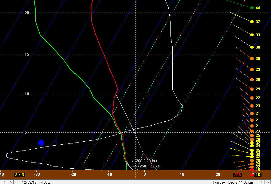
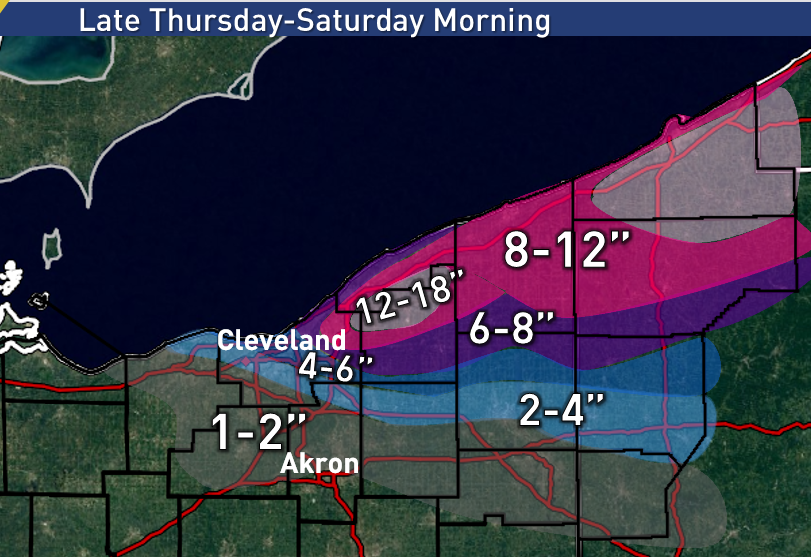
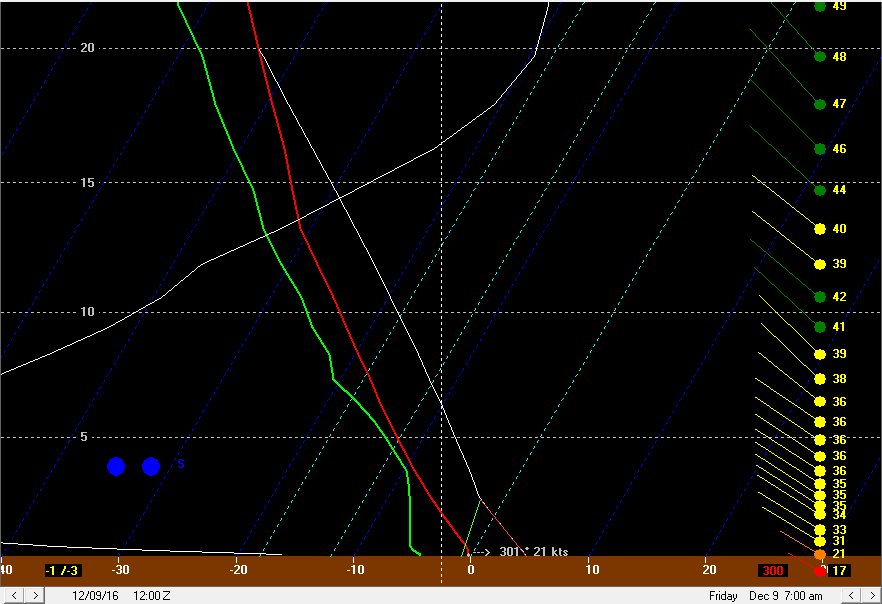
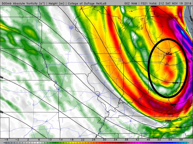
An unseasonably deep trough will move across the Great Lakes Thursday through Saturday, bringing with it a deep cold air mass, sufficient moisture, and a broad cyclonic flow across the warmer than average Great Lakes. This will result in the second lake effect snow event downwind of Lake Erie of the season. This one will be of longer duration, favor lighter winds, a longer fetch, and colder temperatures, likely resulting in much more substantial totals than the first one (2-6” in NE OH). As the cyclonic flow begins developing over the region Thursday morning, a band of snow will likely develop over the lake and hug the lakeshore in Lake and Ashtabula Counties, before moving into Erie County PA and Chautauqua/Cattaraugus County NY. The band will likely hug the north half of those counties. We’ll actually be in a region of subsidence with mid-level drying through early Thursday afternoon behind a shortwave trough moving over the region early Thursday morning, however the long fetch and moderate instability will likely allow decent accums to being across parts of NW PA/SW NY on Thursday with this band. By Thursday evening, a weaker shortwave or vort max is expected to drop across Lake Erie between 5-10PM. This will cause inversions to rise and mid-level moisture to increase, while also bringing a surface trough and wind shift with it. The winds will shift from WSW in the low levels to more of a W Thursday evening as this trough pushes through. This will likely push heavier snow into the NE OH lakeshore Thursday evening and push it a bit farther inland of NW PA and SW NY. With the passage of this first trough, inversion heights will increase to around 10k feet and moisture depth will increase to around 8k feet, allowing the intensity of the lake effect to increase: Although the shear looks bad, it’s much better aligned over the lake, and will result in strong convergence near the lakeshore as stronger, W to WNW winds over the lake run into weaker WSW winds over land. The stronger WNW winds over water will try to push the snow inland some Thursday evening, however the WSW winds over land suggest the better snow will hug extreme NE Cuyahoga County, Lake County, Geauga County along and north of US 6, the northern half of Ashtabula County and into Erie County through Thursday evening. The instability and moisture support snow rates of over 1” per hour assuming convergence can develop as it appears it should and focus better snow in the aforementioned area. The 12km NAM does show this zone of convergence, extending from as far west as Lorain County into inland Erie County PA, with the convergence stronger farther east. This favors moderate to heavy snow in the northern NE OH primary Snowbelt and into a good chunk of Erie County PA (and also the ski-country in SW NY) Thursday night. The convergence will not move much for several hours, so several inches could be picked up in these areas Thursday evening into the overnight, with locally over 8” in NW PA/SW NY through 4am Friday where a longer fetch, more terrain, and seemingly stronger convergence could contribute to heavier snow. Between 4am and 10am Friday, another shortwave will rotate around the larger trough to our northeast. Although the upper level shortwave stays to our northeast, the surface reflection will move southeast across Lake Erie as a well-defined trough. This will initially really increase convergence along the lakeshore early Friday as winds back a little bit on land ahead of the trough, and turn more WNW to even NW over the lake behind the trough. The upper level support for this surface trough will stay to our northeast, and the surface trough will be moving into high pressure nosing into the Ohio Valley, so it’s questionable how quickly this trough pushes through. Regardless of how quickly the trough pushes through Friday morning, conditions for lake effect will go from “pretty good” to “pretty outstanding” Friday morning, with moisture depth improving to 10k feet, inversions rising to 13-15k feet, and winds in the low levels weakening a little bit and increasing residence time over the lake. Lake to 850mb, 700mb, and 500mb differentials will push or exceed 20C, 30C, and 40C Friday morning as the trough pushes through…all of these values are “extreme” and support a few lightning strikes with any good snow bands Friday morning near the lake. Snow rates of 2” per hour are quite possible with the band along the surface trough Friday morning. The question is, how quickly does the trough and band push south? I suspect the heart of the primary Snowbelt…far NE Cuyahoga, southern Lake, northern Geauga…will see a few hours of very good snow ahead of and along this trough given the W to slightly S of due W wind direction ahead of the trough. From there, winds only go WNW behind the trough, with the best upper support remaining well NE, and with surface ridging nosing into the Ohio Valley. This suggests that the trough will not push south super-fast, and may not push the snow band farther south than northern Lorain County/southern Cuyahoga County/the Geauga/Portage County border. This may drop a quick 1-4” on much of the Cleveland metro as well as southern Geauga County, inland Ashtabula County, and southern Erie/most of Crawford County PA given likely intense snow rates and gradual progression of the trough and accompanying snow band. Behind the trough for late Friday morning and afternoon, shear is weak, the flow is a favorable WNW and not too strong, instability remains extreme with high inversion heights, and moisture depth remains respectable. Decent lake effect snow should continue. The big questions for Friday behind the trough will be whether some sort of band can maintain itself across the southern Snowbelt and allow for a more focused area of moderate to heavy snow, and whether or not we can get any upstream connections. The environment is pretty freakin good for lake effect snow on Friday, so it’s just a matter of capitalizing on it: The WNW low level flow does suggest a continued connection off of southern Lake Michigan through the day Friday, which would suggest some decent snow in the Cleveland metro and primary Snowbelt in NE OH. This flow would take the Lake Superior connection (which is actually rather common) into NW PA. The 850mb flow is a bit more NWrly and takes the southern Lake MI connection south of Lake Erie and takes the upper lakes connection into the Cleveland metro and Snowbelt. The well aligned low level flow off of lower Lake MI and some convergence along the way suggests that connection may contribute to snow in the Cleveland metro on Friday, with upstream lakes keeping things going in NW PA/far SW NY during the day behind the trough. Convergence will probably weaken some Friday with an absence of a trough to our NW, and also with temps on land warming up some and decreasing the temp differential over the lake a little bit. Regardless, remnant convergence from the morning band and some remaining lake to land temp and wind differentials should allow some loosely organized snow to persist on Friday across the Cleveland metro and southern Snowbelt. I don’t expect a firehose band, but with such a good thermodynamic profile and some pre-seeding from Lake Michigan there could be good bursts that add up to at least a couple to few inches during the day Friday behind the trough. This will be the best chance for parts of Lorain, Medina, Summit, Portage, southern Trumbull and Mahoning Counties (particularly northern portions of this corridor) to see some accumulation. A good question is how much of a break will the northern primary Snowbelt see on Friday during the late morning and afternoon. In NW PA and SW NY, there doesn’t look to be strong convergence, but there may be decent connections to Lake Huron and Lakes Superior/Michigan (northern). This may cause snow to shut off along the shore (outside of any upstream connections) but decent snow could keep going in the higher terrain, particularly in any upstream connections. In NE OH, I expect northern Ashtabula and Lake Counties to see snow really slow down and possibly shut off Friday late morning and afternoon…however, convergence and orographic lift just inland may allow at least snow showers to continue in far southern Lake County, Geauga County, and southern Ashtabula County in the higher terrain…though they may become less organized. This may support a few inches behind the trough in the higher terrain of Erie and northern Crawford County in NW PA and a couple inches in far southern Lake County/northern Geauga County in NE OH through Friday afternoon…with perhaps a few inches a little farther south in NE OH where convergence tries to persist. There may be an interesting setup Friday night into Saturday morning as ridging builds closer and slowly backs winds. There is pretty good agreement on a good southern Lake Michigan connection developing Friday evening, with the potential for strong convergence developing near the central lakeshore as temps cool on land and as winds on and go light and southwesterly: This could favor a more organized convergence band re-developing Friday evening and persisting into Saturday morning. With a W or WNW wind initially, this band could initially develop over northern Cuyahoga and central Geauga County before slowly shifting north later Friday night into Saturday morning. Conditions will remain favorable for decent LES through Friday night before degrading Saturday morning: Upper level temps warm a little bit, but the low and mid levels remain plenty unstable and moisture Friday night for heavy snow rates should a band form. Any upstream connection would only increase the likelihood of heavy snow Friday night, and the somewhat weaker low level flow may also favor heavyier snow. Winds suggest this band will shift to northeastern Lake, northern Ashtabula, and Erie PA counties by sunrise Saturday. Snow rates of 1-2” per hour may be possible under this band, with the potential for the band to persist long enough to drop a few or locally several inches Friday night. Winds should shift enough to finally push the band out of Erie County PA by mid to late Saturday afternoon, bringing this event to a close. As for accumulations…I expect 2-6” through mid Thursday afternoon in northern Erie County PA and into northern Chautauqua/Cattaraugus County NY with a WSW flow band that should start developing by morning and become fairly intense by afternoon. Coastal Lake and Ashtabula Counties may see a light accumulation from this. By Thursday evening I expect the snow to intensify and push a bit farther south, and this could produce another few inches (3-6”?) through Thursday evening in Chautauqua/Cattaraugus County NY, Erie County PA and Lake and northern Ashtabula County in OH as the first trough pushes through and winds go more westerly. Far NE Cuyahoga and northern Geauga may also see light accumulations through Thursday evening. These accumulations in NW PA and SW NY should be focused a bit south of where the initial band will dump through mid-afternoon. Thursday evening into the overnight will likely see the band hold steady or shift ever so slightly farther south with a WSW surface flow on land and WNW flow over the lake. Lake effect conditions gradually improve, and this could produce another few inches (2-6”) through 4AM Friday in far NE Cuyahoga, northern Geauga, Lake, northern Ashtabula, and Erie PA (into inland SW NY). The band will intensify ahead of the next trough and then gradually push south into the Cleveland metro and southern Snowbelt. This whole process could produce a few inches in the northern Snowbelt initially while the band intensifies early Friday, and then 1-4” in the southern Snowbelt and Cleveland metro through mid Friday morning as the band swings south. Friday late morning through afternoon may feature the snow becoming less organized…however upstream connections, longer fetch and upslope into NW PA may produce a few more inches in this timeframe, with perhaps a few inches where the remnant convergence band and southern Lake MI connection set up into parts of the Cleveland metro (possibly western and southern suburbs) and southern Snowbelt. The band Friday night may produce a couple inches in eastern Cuyahoga/southern Geauga and up to several inches in northern Geauga and Lake/Ashtabula and into NW PA as it re-flares and then very slowly shifts NE. NW PA may see some more Saturday morning before it finally ends. All together…given the potential for multiple instances of banding with moderate to heavy snow, and perhaps even continued accumulating snow showers between periods of banding, think there will be over a foot in the typical hot spots in southern Lake/northern Geauga and inland NW PA. Inland NW PA may see locally up to 2 feet where any upstream lake connections develop on Friday. Drew the sharp southern cut off from northwestern Cuyahoga County southeast through far northern Summit, northern Portage, and Trumbull Counties. Winds get WNW for a time, but lake aggregate troughing tends to be stronger when the lake is warmer, and ridging building in on land suggests the trough/convergence band Friday may not make it extremely far inland. For the Cleveland metro this is tough…may be a couple of windows for banding near the shoreline late Thursday night through Friday evening which could produce a few inches, even down to the shore. Farther east, there may be a good shot of banding through very early Friday another shot Friday night into early Saturday, so amounts along the shore could be decent. There could be graupel near the lake given how warm the water still is which may hurt ratios near the shore and keep higher amounts inland a bit. Inland could see 15-18:1 ratios with temps below freezing for the event. High res models are iffy on amounts…BUF WRFs look good through early Friday but don’t run out any farther. NMM is similar to this idea but struggles to develop an organized band at times and is lighter on amounts…ARW seems lost. 4km NAM isn’t far off from this idea but also struggles to organize bands and shows lighter precip than you’d expect given the setup, and hence shows much lighter amounts. The 12km NAM and SREF consistently show snow, perhaps in a band, in the Snowbelt, and these low-res models combined with the setup do argued for a prolonged heavy event with good totals in the heart of the Snowbelt. We’ll see. With all of that said...here's my map:
-
Yes, I am done. This would have been finals week had I not been done, so it's more than somewhat possible that I would've been busier at school than I am at home this week...go figure. If I get 2 or 3" I'd be happy...then maybe some synoptic over the weekend.
-
Interesting update. Working so damn much this week but I'm gonna take a good look tonight. Should be a decent event.
-
That CLE map from the AM isn't extremely far off from my thinking. I'll probably post my forecast at the normal time, like 2am
-
Solon and Euclid tend to have fairly reliable spotters, but in between we only occasionally get reports from Shaker, Beachwood, and Mayfield Heights. Those middle 3 are really helpful in these setups if they report. And I'm just hoping for a good winter since I'm here for it, may be out east next winter.
-
I suspect you'll do fairly well, but will be close to that cutoff. Down my way I'll be happy with 3"
-
Definitely looks interesting coming up. I'll probably be about 10 miles too far south, but that's what a car is for I guess. A few disagreements with CLE. With a pretty sharp little trough dropping southeast Thursday night, I definitely expect a strong single band to form over the lake Thursday evening...initially this may just graze the NE OH lakeshore and impact Erie County PA and SW NY more directly, and this could quickly produce several inches there Thursday evening. The "shear" CLE noted is an extremely obvious signal for the trough coming through and switching winds around to the WNW. Most of the times when this happens a strong band gradually pushes SW through the NE OH Snowbelt and gets into a good portion of Cuyahoga County. I'll grant that this setup isn't conducive to the band locking in for any period of time in one spot, but I do expect a pretty strong band to push into the Cleveland metro late Thursday night/early Friday morning. How quickly the band moves will determine if it just drops an inch or 4" as it pushes SW Thursday night. The NAM is pretty gradual with the wind change and could allow it to move slow enough to drop a few inches in spots. By Friday morning the models lock in a fairly well-aligned WNW flow with winds in the mixed layer 25 knots or less. This may be a little too strong for the immediate lakeshore to do really well, but I think the wind direction/lack of shear, along with high pressure nosing into the Ohio Valley from the west, supports at least a loosely organized band persisting across most of the Cleveland metro and into Geauga County for most of Friday. Instability is moderate to extreme and moisture looks good, so this could drop another couple to locally several inches during the day Friday. This may be my window to pick up like 3" in extreme NE Summit County. Winds gradually start backing Friday night as high pressure noses in, but instability and moisture remain decent, so even though the snow will start gradually shifting NE Friday night it could be heavy enough to drop another few inches on the primary NE OH Snowbelt Friday night. The low level ridge axis doesn't get to NW PA until Saturday evening, so they may see decent snow through most of Saturday up there. Right now I'm loosely thinking 8-14" in northern Geauga County and southern Lake County, and 6-10" amounts surrounding that from the Heights suburbs into more of Geauga County. There could be a pretty sharp southern cutoff in SE Cuyahoga and southern Geauga County, and this could be near or just north of 422. This setup will probably drop a few inches closer to the lake from Cleveland into the western suburbs...whether the immediate shoreline sees that much is questionable. NW PA could see well over a foot, particularly in the higher terrain just inland from the lake in Erie County. I'm a little bit irritated that CLE isn't even including Cuyahoga County in the hazardous weather outlook for the LES. They had a ridiculous mental block on issuing any lake effect products for Cuyahoga County last winter when the flow was WNW, and it looks like they're going to continue that this winter.
-
The terminal Doppler will help for the Cleveland metro, but less than optimal timing for the nicer radar to be down.
-
The band may start towards Erie or SW NY initially on Thursday but it's looking like we get WNW winds for a good period late Thursday night through Friday evening with extreme instability and ample moisture...we have a couple days for adjustment obviously, but at this point it looks good for a solid warning criteria event for Cuyahoga, Lake, Geauga, along with parts of Ashtabula and NW PA and south of Buffalo. This won't be an epic event but if it's close to the GFS it'll be a decent event for a number of areas.
-
The GFS and Euro runs today do bring winds around to the WNW at some point with the first cold snap late next week...really depends on how quickly/when/if a cutter blows up on the leading edge of the cold. If it blows up to our east or not at all, as opposed to cutting well to our west, we may have a prayer of bringing the winds around to the WNW. The setup looks conducive to a significant lake effect event, somewhere...all depends on the wind direction. This forecast sounding from the GFS is pure porn for the Cleveland metro and Geauga County.
-
A big cutter that goes way to our north always struggles to bring the winds around to WNW, so it's a real concern. But maybe my unbridled pessimism nearly a week out will be wrong.
-
I can see it now. There will be a prolonged significant lake effect event next week but the winds will be SW. The western basin will see water temps plunge into the mid 30s, we'll get a dusting of snow, and south of Buffalo will get 3 feet. Book it.
-
A little under an inch and a half here. Definitely expected more. I think the strong winds helped locations farther south and west do better than the normal locations. We'll see what reports come up but this will be an ugly verification for my nap.
-
Goes without saying CLE needed an advisory, seeing as though: 1) First accumulating snow of the season 2) Very windy, causing very low visibility in these bands 3) Some spots will hit the criteria outright anyways But, you know when the ground temp is in the upper 40s or whatever it is it may as well be a frying pan and nothing will stick at all until 8" falls. While I'm ranting, while I don't mind positive busts in the lake effect department, I'm annoyed about missing that bigger band on the west side. That type of band is always possible when the winds go from WSW to NW and swing a primary band inland, but I really thought with a WNW flow the band would be 5-10 miles north of where it ended up. I also wasn't confident in it occurring, so I really underdid amounts in that area.
-
Same here, roughly 1" and not much going on ATM. Montville has already seen 4", so it looks like amounts from that band ranged from about half an inch to 4". That band west and south of Cleveland has been doing some work...someone in Medina County or maybe even Lorain County will end up with over 4". Lake effect appears to be picking up upstream off of southern Lake Huron and winds will shift a bit more so I'm sure we'll see coverage increase and see bands shift to areas currently not seeing snow.
-
Good bursts sticking almost immediately with this band.
-
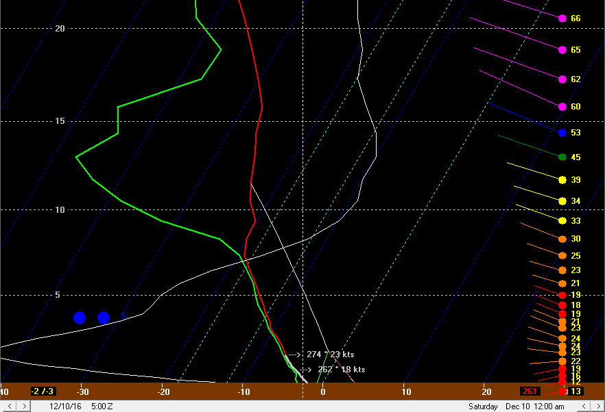
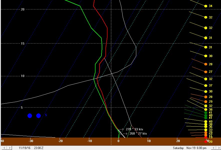
It’s a beautiful site! After being transplanted to a Virginia-like climate for the last 12 or 13 months, the models have a closed low just to our northeast Saturday night, with plenty of cold air and synoptic moisture moving over the unseasonably warm waters of Lake Erie. Finally, the wait is over and our first true taste of winter is here! A band of ana-frontal/post-frontal rain will not clear eastern OH until late Saturday morning/around noon near the PA boarder. 925mb temps will crash to 0 to -2C by 13-14z/8-9AM, with surface temps in the upper 30s to near 40. These low level temp profile will be marginally supportive for some flakes mixing in on the back edge of the ana-frontal rain band. So, this basically means that we’ll start our Saturday on a positive note, assuming you like mangled snowflakes mixing in for 20 minutes with gusty winds and falling temperatures as much as I do. It doesn’t mean much more, because the precip will briefly pull out of the area before anything more interesting happens. Interesting weather returns late Saturday afternoon/early evening as a vort max rotates across northern Ohio and Lake Erie. This vort max will move in on the leading edge of wrap around moisture, and also be accompanied by a surface trough/wind shift that will drop southeast across the lake. Oh, this is exciting already! Here is the surface map, showing a noticeable kink in the isobars and shift in the winds. The winds ahead of the trough over NE OH/NW PA are WSW, with winds behind the trough out of the WNW. These are fun wind directions, because it gives a long fetch for the trough to work with over Lake Erie, and also brings pre-seeding from southern Lake Michigan. The thermodynamic environment as this trough pushes across the lake will become extremely favorable: Deep moisture to nearly 20k feet, over 700 J/KG of lake induced CAPE, with equilibrium levels near 13K feet, along with the convergence with the trough and likely pre-seeding from Lake Michigan will combine to generate intense precipitation along the wind shift as it pushes off of Lake Erie. A band may briefly form over the lake parallel to the shore in the WSW flow ahead of the trough and swing inland. 925mb temperatures of -2 to -3C and 850mb temperatures of around -8C as the trough pushes inland will easily support all snow (or perhaps graupel) with any decent bursts of precipitation. Inland it probably won’t take much of a burst to fall as graupel or snow, as these temperatures are a couple of degrees C colder than what it normally takes to get early-season accumulating lake effect snow. The trough pushes south fairly quickly, however many areas will likely see a quick burst of snow. Given the likelihood of intense precipitation along this trough, some areas could see a quick half inch or inch of snow as the trough pushes inland…even the lakeshore may see accumulations if a good burst moves overhead. The layer of instability may be just deep enough for a few lightning strikes as the trough pushes on shore. Behind this first trough, the isobars will become oriented just north of true NW to SE, with WNW surface winds. The isobar pattern is very close to historic isobar patterns for heavy single banded snow in Cuyahoga County, but is perhaps oriented slightly more N to S than the average of those events. The winds are also stronger. With that said, some convergence should still set up due to friction and the colder air inland butting up against the lake modified air, and based on the strong flow possibly pushing the convergence a bit inland, and isobar pattern, the potential for a more focused area of snow showers will extend from Lorain County east through the southern half of Cuyahoga County into Geauga, inland Ashtabula, northern Trumbull and southern Erie PA Counties. The strong winds will likely prohibit a true primary band from forming, but enhanced convergence in this area should result in better snow. The instability and moisture remain very favorable through the overnight, with equilibrium heights hanging near 12k feet and deep moisture lingering to 10k feet or higher into early Sunday morning. With strong wind hitting the terrain at a fairly good angle, I expect the combination of some convergence as discussed above and orographic lift to wring out decent snow across the higher terrain in NW PA, inland Ashtabula, Geauga County, eastern Cuyahoga County, and likely into the hills in northern Summit County, southern Cuyahoga County, and northern Medina County through the night. In addition to the relatively favorable looking wind direction and convergence, but upstream moisture from Lakes Superior/Michigan will likely swing from NW PA Saturday evening into the primary NE Ohio Snowbelt overnight Saturday night, and perhaps onto the west side Sunday morning as the winds gradually veer to a more northwesterly direction. Any upstream connections may result in locally heavier bands of snow, despite the relatively strong winds and some wind shear otherwise preventing strong banding. A Lake Huron connection will also edge west into NW PA early Sunday morning. The deep synoptic moisture, convergence south of the shore, orographic lift, and strong instability support a general snow downwind of the lake focused on the higher terrain, but any of these upstream connections will support narrow heavier bands of snow within that. The NAM and GFS both bring one last vort max across Lake Erie and into north central and northeast Ohio very early Sunday morning; this could bring another intensification in the snow for a few hours very early Sunday, both due to the added lift from the vort max and the subtle surface trough/wind shift with the vort max adding to the low level convergence near the lakeshore. My general rule of thumb is that moderate to heavy lake enhanced snow will continue until at least when the 70% RH line at 700mb moves east of the area; the general consensus is for this to occur around 7-8AM in Cleveland on Sunday, by 10AM in Geauga County, and around noon in Ashtabula County. As the low cuts off and slows over New England this drying will really slow as it reaches NW PA, and they may remain in the moisture cyclonic flow into Sunday night, before gradually drying into Monday. This suggests the large blob of decent snow will end in NE Ohio Sunday morning from west to east, but perhaps linger over NW PA through Sunday and into Sunday night. The SREF mean matches the recent GFS/NAM/Euro runs fairly well with how quickly it moves the 70% 700mb RH line east Sunday morning. Several members are slower and would keep heavier snow going longer in NE OH Sunday morning, and it’s worth noting that just small changes in the models WRT their handling of this cut off low may have impacts on how much snow falls in NE OH. The models have been relatively consistent their last couple of runs, so we’ll see if the current consensus holds up. Even after the best moisture strips away, the instability/moisture profile aren’t “horrible” for pure lake effect that may be leftover. Equilibrium levels take until Sunday evening to fall below 10K feet, and moisture is solid at and below 5k feet, and into the DGZ all of Sunday. The flow is WNW which isn’t the longest fetch but also isn’t the shortest, and winds in the low levels, which still a little stronger than preferable, do weaken some compared to Saturday night. This leads me to believe that disorganized light to moderate snow showers will continue on Sunday. With 850mb temps of colder than -10C, clouds/snow showers around all day, and probably some snow on the ground in most of the Snowbelt away from the shoreline, highs on Sunday will struggle to hit freezing in many spots and any additional snow showers may produce an additional inch or so in spots Sunday afternoon. With a WNW to NW wind, I’d expect any connection to the upper Great Lakes to move into the Cleveland metro and/or primary Snowbelt Sunday afternoon. Although the atmosphere will be drying some, sufficient instability and improving low level winds (weakening speed and directional shear) may allow for a disorganized band or two to possibly form downwind of these upstream connections through Sunday afternoon, especially where the bands hit higher terrain. This may be where spots pick up the additional inch or so I discussed above Sunday afternoon. At this same time, a healthier Huron connection (and better synoptic moisture) will affect NW PA; with a WNW to NW flow, the band may not edge as far west as the ARW has it (near Meadville), and may stay in central or eastern Erie and Crawford Counties. The NMM traditionally does not have as bad of a bias for placing bands too far southwest, and is a little farther east with that band. With strong winds that are gradually shifting, the ARW’s solution of stalling a single and extremely intense Huron band on Sunday may not be realistic. A more diffuse moderate to briefly heavy band that moves a little bit across NW PA seems more reasonable given the strong winds. As we head into Sunday night, the inversion slowly lowers and moisture starts stripping away above about 4k feet. This sounding has just enough juice for maybe some light accumulations Sunday night, mainly driven by the extreme temp differential between the lake and 850mb still allowing for about 500 J/KG of lake induced CAPE under the inversion. With the winds in the low levels finally weakening below 30 knots and gaining a bit more of a westerly direction, this may try to favor lose organization of snow showers from the Cleveland metro east. A negative here is that high pressure building in from the west will likely shut off upstream connections into NE Ohio Sunday night. Overall, if a band does try to develop Sunday night, some spots may see another inch or two of snow, but nothing very substantial. In NW PA the deep synoptic moisture will finally pull east Sunday evening, allowing for the steady orographic enhanced lake enhanced snow to taper. With that said, instability and moisture depth remain a little bit deeper, along with a possible Huron fetch that may not shift east into SW NY until Monday morning. This could allow some spots to squeak out another 2-4” in the higher terrain of NW PA Sunday night. I don’t expect another to see more than nominal addition accums in NE OH or more than an inch in NW PA on Monday. So, all in all, this is a tough forecast. Many signs point towards a lot of lake enhanced/effect precipitation, including the favorable fetch, upstream connections (especially NW PA), very good moisture/instability, and orographic lift. The one negative is strong winds/wind shear limiting band organization until perhaps Sunday afternoon and Sunday night…by then the other good factors will start diminishing for NE OH and by Sunday night in NW PA. Another negative is warm ground and air temperatures. I suspect that once inland locales get a little snow down that with air temps falling to near freezing that ratios can increase to near 10:1 inland by later Saturday night and Sunday…especially in the higher terrain of NW PA. Near the lake temperatures may not get to freezing until Sunday night, keeping ratios much lower and constantly melting any snow that does stick. So, although some bursts may occur at times near the lake and accumulate a little, big accumulations are highly unlikely near the lake. For NE Ohio, I figure the flow and terrain favor eastern Cuyahoga and most of Geauga County Saturday night. It appears that a good 12 hours or so of moderate snow is possible here. Again, with the lower ratios, especially at first, and likely lack of an organized, dominant band that drops a ton of snow at once, amounts will probably stay somewhat under control. With that said, such a long window of decent snows into Sunday morning leads me to believe that a few inches…IE 3-6”…are quite likely to fall in most of Geauga County through Sunday morning, especially in the higher terrain in central and northern portions of the county. Another inch or two of snow from snow showers Sunday afternoon and Sunday night could push totals over 6” and up to near 8” in the higher terrain of northern Geauga. How far south and west to extend the snow is tough, as the hi-res models really want to get a good portion of Medina, Summit, and Portage in on the act. With a strong WNW flow I do expect northern portions of these counties to get in the act Saturday night into early Sunday, but the isobar orientation along with typical hi-res model bias to place bands too far SW suggests that only the northern portions of these counties will get in the act. Normally, a prolonged WNW flow band into these areas can produce decent totals, but with a little bit less terrain here than farther east, moisture moving out faster in these areas, and a likely lack of a big band, I will keep amounts in these areas to 2-4”. I don’t expect much if any additional snow here after Sunday morning. If a better band does form, the secondary Snowbelt could see a locally higher amount under that band…but at this time that doesn’t look very likely. Due to a prolonged WNW flow off of Lake MI and strong winds carrying bands well inland, parts of the central highlands may see light accumulations as well. Only allowed an inch or two at the lakeshore and in spots that will be generous. For NW PA, stronger orographic lift through the event and an additional 6-12 hours of favorable synoptic moisture along with Lake Huron moisture will allow for considerably higher totals. I’m looking at a 30 hour period of pretty good snow in the higher terrain of NW PA, with light to moderate snow showers lingering for several hours after that into early Monday before finally ending. Snow ratios in the higher terrain of NW PA should be a bit higher due to slightly colder temps and also better odds at quickly establishing a snow pack to build on. With the Huron band likely meandering and not being extremely intense, and still lower than optimal ratios, I struggle to see more than 18” or so as the jackpot in NW PA…but I do foresee a rather large area seeing at least a foot. If the Huron band can stall for a few hours, which again seems less than likely, then a local spots may see easily 2 feet of snow. Here's my map:
-
This is shaping up to be an interesting forecast to say the least. As it stands, I expect a significant event for NW PA and SW NY, with 8-16" totals in the higher terrain in inland Erie County, northern Crawford County, and Chautauqua County. BUF issued a watch this afternoon for SW NY and CLE should have followed for NW PA IMO. For NE OH it is tougher...despite some negatives that CLE mentioned in their AFD, there are enough positives that there should be a decent period of moderate to heavy lake enhanced snow in the higher terrain of the Snowbelt Saturday night into early Sunday. Most models currently strip the best moisture away by Sunday morning, so if that verifies we'll probably be left with less significant snow showers that linger through Sunday night. My current guess is for 4-7" in the higher terrain in northern Geauga and inland Ashtabula Counties by Monday morning, with perhaps a few inches in eastern Cuyahoga, southern Geauga, and maybe 2-4" type amounts sneaking into NE Summit and northern Portage. I still don't expect a ton by the shore, but if there are good bursts, which appears possible, the ground could whiten. Exactly how quickly the upper low cuts off is key to our forecast. The current consensus, which is what I based my quick forecast above off of, is for the low to close off late enough that NE OH looses the better moisture and upper level support by Sunday morning. We'd still get a good period of lake enhanced precip Saturday night into early Sunday, and lake effect conditions remain OK into Sunday night, but the heavy enhanced precip shifts east into NW PA/SW NY on Sunday, where it then dumps for another 12-18 hours into Sunday night before starting to taper there too. The GFS is a little faster than this, although the 18z run slowed down a little bit. The NAM and Euro are just slightly too fast for NE OH, but are a tick away from being a significant event for the primary Snowbelt here as well. So, things can still trend better or worse, but as it stands we are near the edge but should still see something half decent.
-
This weekend has my attention, with a cut off low nearby to the NE. A couple ways this can bust, either it speeds up too fast (faster than the current GFS) and we get limited moisture and a short LES window, or cuts off too far south (similar to the current run of the Canadian) and warm air wraps in from the east and keeps us mainly rain. The middle solution involves possible lake effect/enhanced snow with lift from the low adding to that...similar to the 0z Euro. Models haven't settled on a solition yet and it's a fickle setup with the low closing off. Runs that don't have the low closing off, like the recent GFS have plenty cold temps for snow by Saturday night but have less moisture and about a 24 hour LES window. The Euro has toyed with the idea of closing the low off, keeping us under favorable moisture and lift longer and keeping us just cold enough for all snow, which is the best case. Problem is if the low closes off and the cold air gets cut off there's less margin for error, and we run the risk of not being cold enough for good accumulations. So, temperature questions, moisture questions, the usual. Lakeshore may not do well either way (sorry Trent), but inland this is a high potential event, but still with lots of time and ways to bust. I'd give it another day or two before getting too excited. Another issue is a few trees still have leaves and if it does snow it'll be wet and accompanied but decently strong winds.