strongwxnc
-
Posts
6,473 -
Joined
-
Last visited
Content Type
Profiles
Blogs
Forums
American Weather
Media Demo
Store
Gallery
Everything posted by strongwxnc
-

2022-2023 Fall/Winter Mountains Thread
strongwxnc replied to BlueRidgeFolklore's topic in Southeastern States
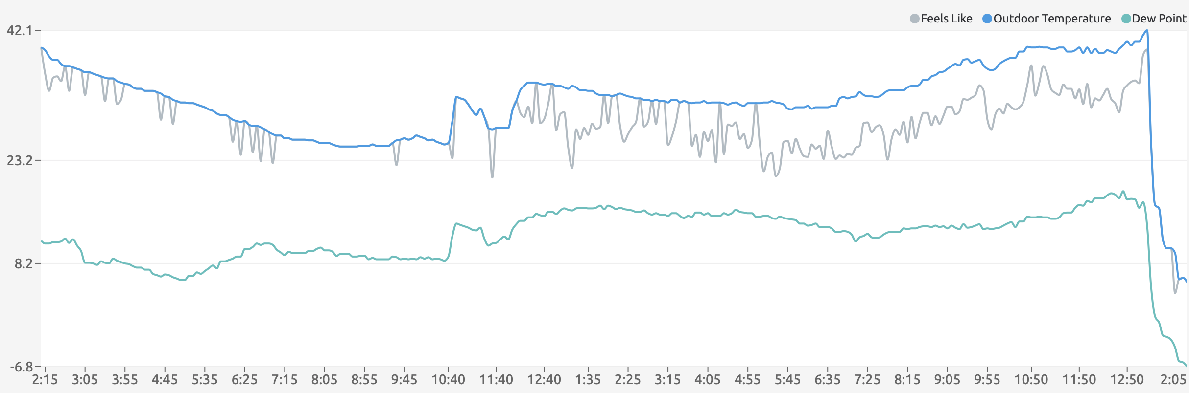
Cold low temps the last few mornings: 12/23: 9.9 12/24: 7.0 12/25: 7.9 12/26: 9.0 -
2022-2023 Fall/Winter Mountains Thread
strongwxnc replied to BlueRidgeFolklore's topic in Southeastern States
I have folks close to me without power. We are running good here and I hope it continues. Glad we installed ventless gas logs back in 08. They work great to regulate the temp in the house. I think my bottom is going to be 8.1 lowest wind chill was -10.7 last night. Time to check on the horses and chickens! . -
2022-2023 Fall/Winter Mountains Thread
strongwxnc replied to BlueRidgeFolklore's topic in Southeastern States
11.1 with winds around 7. -1.4 wind chill Hoping that wind dies down some time! . -
45.5 at 5:00 am 23.9 currently Highest wind gust was 35.5 MPH
-
2022-2023 Fall/Winter Mountains Thread
strongwxnc replied to BlueRidgeFolklore's topic in Southeastern States
Enjoy man!! Never know when this will happen again for you guys up high! Get a jebwalk in for me Noting but brown/red mud down here at 23. degrees. Here was my temp drop! Front came in around 4:55am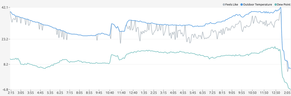
-
2022-2023 Fall/Winter Mountains Thread
strongwxnc replied to BlueRidgeFolklore's topic in Southeastern States
I’ve got very light flurry action! 45 currently . -
2022-2023 Fall/Winter Mountains Thread
strongwxnc replied to BlueRidgeFolklore's topic in Southeastern States
Good luck!! -
2022-2023 Fall/Winter Mountains Thread
strongwxnc replied to BlueRidgeFolklore's topic in Southeastern States
Friday Night Good lord! Snow. The snow could be heavy at times. Widespread blowing snow. Low around 13. Wind chill values as low as -10. Very windy, with a southwest wind 39 to 44 mph, with gusts as high as 70 mph. Chance of precipitation is 100%. New snow accumulation of 4 to 8 inches possible. Saturday Snow. The snow could be heavy at times. Widespread blowing snow. High near 18. Windy, with a southwest wind 32 to 36 mph, with gusts as high as 55 mph. Chance of precipitation is 100%.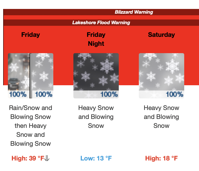
-
37 with .42” Sounds about right for the first day of winter round here. .
-
2022-2023 Fall/Winter Mountains Thread
strongwxnc replied to BlueRidgeFolklore's topic in Southeastern States
My uncle lives in middleville MI and this is his forecast for this week.. Will be a dry awesome snow! . -
Prefect winter day for working outside down here! 47 with a slight breeze! .
-
2022-2023 Fall/Winter Mountains Thread
strongwxnc replied to BlueRidgeFolklore's topic in Southeastern States
Those new bike rides will be awesome! . -
2022-2023 Fall/Winter Mountains Thread
strongwxnc replied to BlueRidgeFolklore's topic in Southeastern States
I’m thinking around 10 is the lowest I’ll get in the foothills. At least in my location. . -
Mid to Long Range Discussion ~ 2022
strongwxnc replied to buckeyefan1's topic in Southeastern States
No doubt. 36.3° currently with overcast skies. . -
2022-2023 Fall/Winter Mountains Thread
strongwxnc replied to BlueRidgeFolklore's topic in Southeastern States
19.8 for the bottom last night! . -
2022-2023 Fall/Winter Mountains Thread
strongwxnc replied to BlueRidgeFolklore's topic in Southeastern States
Would be the worst. But plausible for sure.. Hell, anything is at this point . -
2022-2023 Fall/Winter Mountains Thread
strongwxnc replied to BlueRidgeFolklore's topic in Southeastern States
It was super thick here until about 9am this morning. The sun had to work to burn its off for sure! -
2022-2023 Fall/Winter Mountains Thread
strongwxnc replied to BlueRidgeFolklore's topic in Southeastern States
1.58” at 39 degrees! . -
2022-2023 Fall/Winter Mountains Thread
strongwxnc replied to BlueRidgeFolklore's topic in Southeastern States
No doubt. Run to run throws many different options around for sure. -
2022-2023 Fall/Winter Mountains Thread
strongwxnc replied to BlueRidgeFolklore's topic in Southeastern States
Picked up 1.5 “ ! . -
2022-2023 Fall/Winter Mountains Thread
strongwxnc replied to BlueRidgeFolklore's topic in Southeastern States
A drive may be in order this weekend then -
Historic Lake Effect Event?! 11/17-11/21
strongwxnc replied to BuffaloWeather's topic in Upstate New York/Pennsylvania
That is a great picture! Love low visibility in the day light1 -
Historic Lake Effect Event?! 11/17-11/21
strongwxnc replied to BuffaloWeather's topic in Upstate New York/Pennsylvania
Awesome video. Thanks for sharing!! -
Mid to Long Range Discussion ~ 2022
strongwxnc replied to buckeyefan1's topic in Southeastern States
I’m out. Only shows 1” for me. Gesh . -
2022-2023 Fall/Winter Mountains Thread
strongwxnc replied to BlueRidgeFolklore's topic in Southeastern States
Cold rain today boys!! Hovering around 40 here .