

John1122
-
Posts
9,692 -
Joined
-
Last visited
Content Type
Profiles
Blogs
Forums
American Weather
Media Demo
Store
Gallery
Posts posted by John1122
-
-
Snow has picked up business here since around 3. Nickel to quarter sized flakes and 1/2 mile vis. It's actually blowing around on roads. Temp is 33.
-
 3
3
-
-
It's raw out there, temp has fallen through the 30s today. The models whiffed majorly on the precip/cold meeting until the very short range when they picked up on it. Still managed a few snow showers and that's not too bad for April 7th. May manage a few more Sunday night into Monday morning. After that I think the snow threat is over until the usual time next fall. Still, it's crazy that we struggle so many seasons to get snow here, but snow can fall in the state every month except June, July and August and add September to that and snow has fallen in every other month in the below 5000 feet regions.
-
1
-
-
The NAM and especially NAM3K are pretty aggressive at 18z. 1-3 inches falling north of 40 with some higher pockets in NE areas. Don't know if that will happen and doubt even 1/2 of that will accumulate but spring has shocked me so far. It may again.
-
1
-
-
My current forecast calls for a mixed bag of rain/sleet/snow for tomorrow with a high of 36 degrees. What a crazy spring! I figured it would be either snow or rain, surprised sleet is working it's way into the equation. You rarely see it outside the winter months in my experience.
-
1
-
-
10-11 was part two of the epic return to winter after the crapfest of the 2007-2009.
As to Jeff's point, I think the 30 year average in Chattanooga was around 8 inches prior to 2000. I know it was over 12 inches for Knoxville then too.
-
1
-
-
I'd be more excited if this were coming through at 8pm to 4am instead of 8am to 4pm. Still the models are generally showing some very heavy snow rates developing across the area. The Euro snow accumulation map shows .5 to 1.5 inch totals for non elevated areas north of 40 and even more in SWVA and Kentucky. That would take really heavy snow falling to get it to stick. It will be aided a little in some areas by the relative cold of the past few days. I was 27 degrees yesterday morning and I'm in the 30s and dropping as we speak. Every little bit helps. As always, northern areas and above 2500-3000 feet are likely to do the best. Everywhere else, if we can get snow in the air, it's a win.
-
3
-
-
Getting NAM'd? This would be impressive. I don't know how much would actually manage to accumulate in Eastern areas as it falls between 8 am and 2pm. It's just so hard to get accumulation during the day this time of year. The legendary April of 87 event started a couple hours before sunset and went overnight if I recall correctly. The GFS is more central Kentucky storm and there's another one on it's heels for Kentucky on the GFS. Even though we're getting close to the event, the modeled track appears to potentially effect anywhere from the Tennessee state line with the gulf states all the way to the Ohio river. Somewhere in that area should see heavy snow falling at the very least, better sticking the further north you are obviously and in areas where precip comes at night.

-
1
-
-
The Euro has snow down to 40. With 1-3 inches accord to what side of the KY/TN line you are on. The GFS is a little further north. The Canadian was a big hitter north of 40. Track and time of day still to be determined but I still think 40 north to the Ohio River is in the window and somewhere in there will be a 100 mile or so wide strip of heavy wet snow.
-
2
-
-
The EPS individual members were impressive. A large number had pretty big events in the region. The Euro itself is probably on the southern edge of it's ensembles by the look of big hitters for the northern half of Tennessee and into Kentucky. There were big hitters in there for everyone though. Crazy that we're in the 5 day range with all major modeling and ens showing a winter event for April 7th-8th.
-
2
-
-
I have a policy of always cheering against Michigan unless they are playing Alabama or Kentucky.
-
1
-
-
The Canadian and GFS ticked north at 12z and the Euro went a little bit south or maintained. Basically a strip of 2-4 inches along the path of the upper low as it swoops across the area. Pretty much a stripe right down the middle, east to west on the Euro with heavier totals as you move eastward. The stripe of heavier snow is about 3 counties wide north to south, also expanding as you work eastward.
All the models seem to agree on the system and that it will produce wintry precip, but they will have to work a while on the track. Looks like the Central Kentucky to Central Tennessee are in the window on the 12z suite.
-
3
-
-
JKL mentions snow, especially for their southern tier of counties due to the Euro and GFS runs taking the ULL further south. MRX doesn't mention it at all.
-
Getting to the 5.5 day point now and the Euro, GFS and Canadian still have a major winter event for the forum area. This storm is being depicted from Northern Kentucky to the Southern Tn border areas over the last few days. So everyone in that window may have skin in the game still. This has shown up on the Canadian suite, the European suite and the American suite over the past several days in some form. I won't post the Euro map, but it's very similar to the GFS but heavier in the Mountains and NC. What a crazy year this will have been if this comes to pass. The Euro Control is 2-4 from Nashville to Crossville, 4-6 along and north of 40 in Eastern areas.


Canadian

-
1
-
 1
1
-
-
I'll always feel like that should be Tennessee playing Nova in the Final Four. I can't imagine anyone faced an easier route to the Finals than Michigan in tourney history. At least by seed.
-
1
-
-
The Euro control snow map is similar area but much heavier snow depth to the GFS mean map above. 3-6 inches across a lot of the northern half of Tennessee/Southern Ky. Canadian still has 1-3 inch snows in the northern part of East Tennessee from the Plateau eastward. Not quite the monster from 00z Friday but it worked it's way back well south with the snow shield.
-
1
-
-
40 minutes ago, tnweathernut said:
This would be the second opportunity to discuss snow in the spring/summer thread. Even though unlikely....... the pattern says it’s not impossible.
The crazy thing is that it follows that with a Plateau/North Central Valley ice storm 24 hours later as waves of moisture work along a stalled but strong Arctic boundary. I would say stranger things have happened, but I'm not sure they actually have. We did get 12 inches of snow in April of 1987 and 9 inches here in May around 100 years ago when my grandfather was a teenager and said the snow laid flat knee high corn. The Canadian has the same system with the boundary stalled a little further north and the northern half of Kentucky gets a big ice event.

-
1
-
-
With the way 2018 is going, this wouldn't stun me.


-
 1
1
-
-
March has been relentlessly cloudy. It seems like we've had about 4 sunny days all month long. On the positive side, I've had 7 inches of snow this month and it got my season total over 12 inches. Something I never thought possible after the end of February. 6-8 inches below normal still, but at least not the complete disaster that 2016-2017 was. The new normal here seems to be boom or bust with 6-12+ inches above normal or 6-12+ below normal.
-
3
-
-
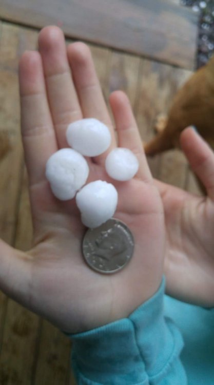
Had a big hailer south of my area at my cousins place. She sent this photo. Big time thunder in the area with temps in the 30s at the surface. Not something you see often.
-
1
-
 1
1
-
-
Been stuck at 37 with off and on rain here today. Probably my least favorite weather condition is 30s with rain.
-
Managed to stay snowy all day long. Very uncommon for March, let alone late March.
-
3
-
-
The forum access is brutal, but the band are pivoting and will soon be coming in from the NE the way the radar looks now. A decent band is working southwest ward from eastern Kentucky and Western Virginia. It seems to have atlantic moisture on it that's being thrown back across the Apps from the Noreaster.
-
1
-
-
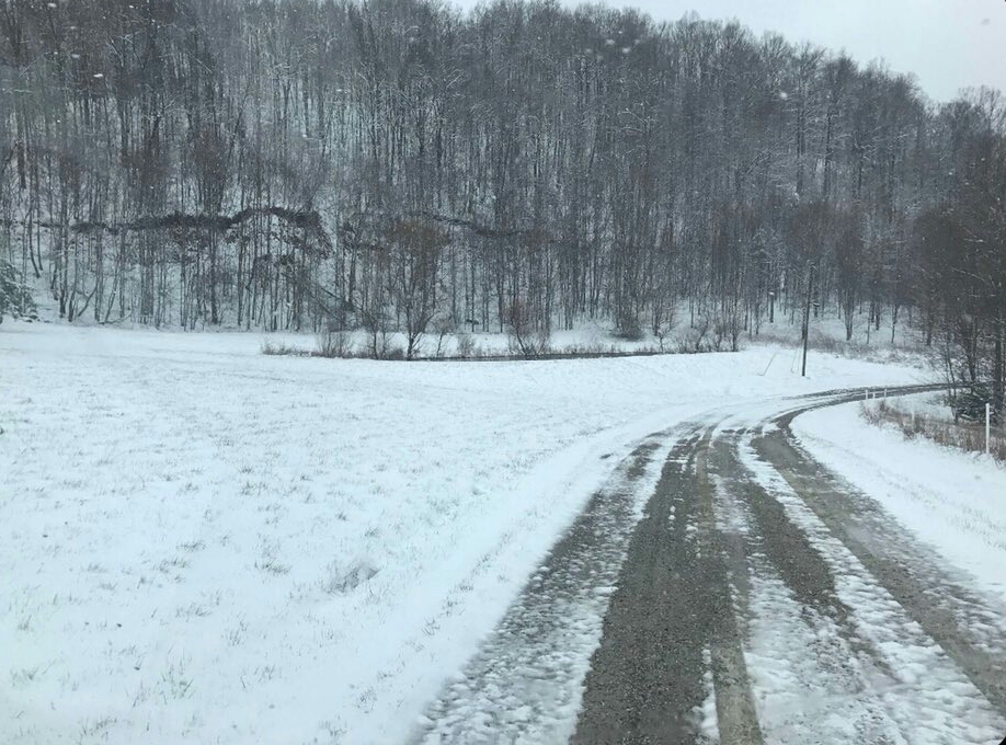
It's a wintry day, I've received another inch of snow since this morning on raised surfaces and it's still snowing steadily in the NW flow. The ground didn't really add much due to melting from below. But all in all, 4.5 inches of accumulation on raised surfaces. The GFS pretty much nailed this one for me and did it a week ago, but did lose it briefly before coming back with it a few days ago.
-
1
-
-
I'm right at 3.5 inches. I'll be surprised if I can add any accumation during the day. It's melting from below and and compacting quickly. That's easily double what I expected and is the biggest event of the season for me.
-
2
-

Spring/Summer 2018 Observations
in Tennessee Valley
Posted
Managed to pick up a coating on the grass and leaves and car tops. It's lightened up at this point but it was neat to see it coming down pretty hard for a while there.