Jns2183
-
Posts
5,838 -
Joined
-
Last visited
Content Type
Profiles
Blogs
Forums
American Weather
Media Demo
Store
Gallery
Everything posted by Jns2183
-
Miss to the south Sent from my SM-G970U using Tapatalk
-
At this point let me rain fall to August. If all grass and trees are dead no worries Sent from my SM-G970U using Tapatalk
-
Which preformed so well yesterday I should be at 1.5"+ Sent from my SM-G970U using Tapatalk
-
There isn't even lightning with those storms. I've been absolutely amazed at how lightning has ceased to exist compared to how it had been Sent from my SM-G970U using Tapatalk
-
@canderson you might have called it with no luck. bring on the drought and kill everything possible so don't have to worry about it again Sent from my SM-G970U using Tapatalk
-
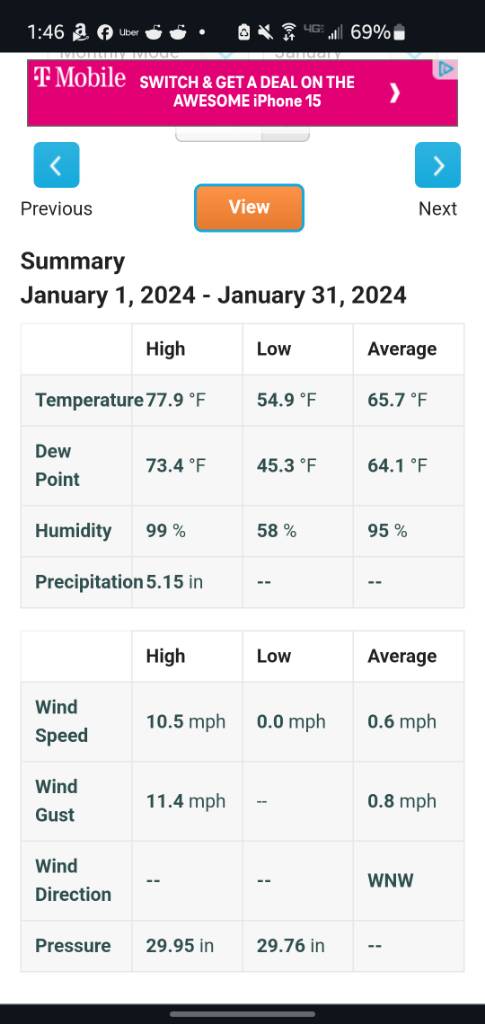
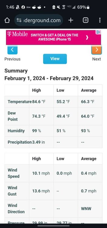
Here you go Costa Rica about 5000 feet elevation January and February Sent from my SM-G970U using Tapatalk

-
I've seen houses in that area get into pretty wooded areas. If there is aravine and creek as well, with his station in a location that may take advantage of local inversions. Sorta like that real cool area you feel walking through the woods. Sent from my SM-G970U using Tapatalk
-
Is he in deep forest? Sent from my SM-G970U using Tapatalk
-
Id so love 2"-4" of heavy rain. It would make me feel a whole lot better about the inferno about to be unleashed on us that I will lock myself inside for till I leave on the 19th Sent from my SM-G970U using Tapatalk
-
If you don't get rain tomorrow things start looking bleak Sent from my SM-G970U using Tapatalk
-
It's high in PA. South of the border is different Sent from my SM-G970U using Tapatalk
-
Not even A speck on radar so far Sent from my SM-G970U using Tapatalk
-
That's at like 5pm Sent from my SM-G970U using Tapatalk
-
I flat out hate anything 90 and above. It won't be above 90 for the entire week down at Hilton head Sent from my SM-G970U using Tapatalk
-
I will be in Savannah Georgia and Hilton Head South Carolina come the 19th next week. Looks like I'll have perfect timing with reasonable weather down there and insanely hot weather here Sent from my SM-G970U using Tapatalk
-
We bake vs we float? Sent from my SM-G970U using Tapatalk
-
If I knew that I would have made them plow down 7 graffiti highways in the hot sun. Sent from my SM-G970U using Tapatalk
-
Convection is so hit and miss. I pray for those cut of low, east wind, +2-+3 sd pwas and 850's. 5 days of nothing but rain where temp is between 62-68. That is a beautiful June forcast Sent from my SM-G970U using Tapatalk
-
I would happily take it. I just have PTSD from last June where models gave me over 13" 24-48 hours out if I added it all up but reality was barely more than an 1". Sent from my SM-G970U using Tapatalk
-
Did 26000 steps at Hershey today. Most of it in a bathing suit. I'm going to be more exhausted tomorrow coming back to work then I was when I clocked out Tuesday after 5 straight days Sent from my SM-G970U using Tapatalk
-
Friday looks like only hope of rain for awhile Sent from my SM-G970U using Tapatalk
-
I hope something. The last few years has produced easily the most boring weather I've ever seen in this area. I figure it has to break sometime. Sent from my SM-G970U using Tapatalk
-
When do you think we get a tropical system up here? Sent from my SM-G970U using Tapatalk
-
Up to 50 errors!! Sent from my SM-G970U using Tapatalk
-
Anyone want to join me at Hershey all day tomorrow? Sent from my SM-G970U using Tapatalk